Related Research Articles

Jefferson County is located in the north central portion of the U.S. Commonwealth of Kentucky. As of the 2010 census, the population was 741,096. It is the most populous county in the commonwealth.

Barbourmeade is a home rule-class city in Jefferson County, Kentucky, United States. It was formally incorporated by the state assembly in 1962. The population was 1,218 at the 2010 census.

The Original Highlands is a historic neighborhood in the Highlands area of Louisville, Kentucky, United States.

Clifton is a neighborhood east of downtown Louisville, Kentucky USA. Clifton was named because of its hilly location on the Ohio River valley escarpment. Clifton is bounded by I-64, N Ewing Ave, Brownsboro Road, and Mellwood Ave.
Irish Hill is a neighborhood east of downtown Louisville, Kentucky USA. It is bounded by Baxter Avenue to the west, Lexington Road to the north, the middle fork of Beargrass Creek and I-64 to the east. Cave Hill Cemetery is located directly south of Irish Hill. It is in the inner Highlands area of Louisville.

South Louisville is a neighborhood two miles south of downtown Louisville, Kentucky, US. "South Louisville" or "South Side" is also used to describe the entire area of Southern Louisville. The neighborhood itself is bounded by Industry Road, the CSX railroad tracks, Central Avenue, Taylor Boulevard, Longfield Avenue and 3rd Street. The world-famous Churchill Downs horse racing track and Kentucky Derby Museum are located in South Louisville.
Beechmont is a neighborhood in the south end of Louisville, Kentucky. Its modern boundaries are I-264 to the north, Taylor Boulevard to the west, Southern Parkway and Southland Boulevard to the south, and Third Street, Allmond and Louisville Avenues to the east.

Crescent Hill is a neighborhood four miles (6 km) east of downtown Louisville, Kentucky USA. This area was originally called "Beargrass" because it sits on a ridge between two forks of Beargrass Creek. The boundaries of Crescent Hill are N Ewing Ave to the St. Matthews city limit by Brownsboro Road to Lexington Road. Frankfort Avenue generally bisects the neighborhood.

Bonnycastle is a neighborhood four miles (6 km) southeast of downtown Louisville, Kentucky USA. It is considered a part of a larger area of Louisville called The Highlands. Its boundaries are Bardstown Road, Cherokee Road, Eastern Parkway and Speed Avenue.
Clifton Heights is a neighborhood two miles east of downtown Louisville, Kentucky USA. It was named because of its hilly location atop a ridge about 100 feet above the Ohio River floodplain, overlooking the adjacent community of Clifton. Though first planned in the 1890s as Summit Park, actual growth didn't begin until after World War I when automobiles made the hilly area accessible. Clifton Heights has had an African American presence since its founding, in 2000 they accounted for 21% of the population. Housing stock includes a variety of styles and time frames, from older shotgun houses and bungalows to suburban ranch homes built in the 1970s.
Camp Taylor is a neighborhood and former military base six miles southeast of downtown Louisville, Kentucky, United States. First announced on June 11, 1917 it was originally a military camp named for former president Zachary Taylor. For a time it was America's largest military training camp, housing 47,500 men at one time, and spurred development in an area that was previously dominated by farmland.
Audubon is a neighborhood in Louisville, Kentucky, United States. Its boundaries are Clarks Lane to the north, Poplar Level Road to the east, Preston Highway to the west, and the city of Audubon Park to the south. The smaller city of Parkway Village is surrounded by Audubon. George Rogers Clark Park, the site of a cabin owned by the parents of George Rogers Clark, is a prominent feature of the neighborhood.

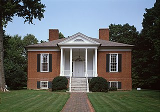
Hawthorne is a neighborhood in eastern Louisville, Kentucky, United States. Its boundaries are Taylorsville Road, Hawthorne Avenue, Bardstown Road and I-264. The land was once part of John Speed's Farmington estate, known for its plantation house built around 1815–16. The neighborhood is primarily residential and was first subdivided in 1909, but saw its fastest grown in the 1920s. It takes its name from Hawthorne Avenue, and most of the other streets are named after writers or poets. Sullivan University is located in the neighborhood.
Poplar Level is a neighborhood five miles (8 km) southeast of downtown Louisville, Kentucky, United States. It is part of the larger Camp Zachary Taylor area.
Cloverleaf is a neighborhood in southwest Louisville, Kentucky. Its boundaries are I-264 to the north, Manslick Road to the east, Gagel Avenue to the south, and the Illinois Central railroad tracks to the west. It takes its name from Cloverleaf Acres, a development in the area. It is residential, and was annexed by Louisville in 1958.
Worthington is a neighborhood of Louisville, Kentucky located along Brownsboro Road and Ballardsville Road. In the 1870s, a toll gate was built on Brownsboro Road at its intersection with Ballardsville Road. In the early 1900s the area was primarily potato farms, but residential development which began in the 1940s accelerated with the opening of Interstates 71 and 265 in the late 1960s.

The Highlands is an area in Louisville, Kentucky which contains a high density of nightclubs, eclectic businesses, and many upscale and fast food restaurants. It is centered along a three-mile stretch of Bardstown Road and Baxter Avenue and is so named because it sits atop a ridge between the middle and south forks of Beargrass Creek. The commercial area extends from the intersection of Bardstown Road and Taylorsville Road/Trevillian Way in the south, to the intersection of Baxter Avenue and Lexington Road in the north, a length of 3.2 miles. A 1/2 mile section of the nearby Barret Avenue also contains many similar businesses. The residential area is separated from other adjacent areas like Germantown and Crescent Hill by the south and north forks of Beargrass Creek. The middle fork runs through Cherokee Park, and the south fork divides Germantown from Tyler Park, after flowing past several cemeteries and undeveloped forests downstream from Joe Creason Park. Due to its large collection of night clubs and restaurants, it is locally known as "Restaurant Row".
Springdale is a neighborhood in Louisville, Kentucky located along Brownsboro Road and Barbour Lane. The community is named for the family farm purchased by Laurence Young and his family in 1830, which was intersected by present-day Brownsboro Road, with the estate on the south side of the road. The Young family's Springdale farm today is the site of the Standard Country Club, as well as portions of Barbourmeade, Goose Creek and Brownsboro Farm. Though it is not a formally recognized neighborhood or district within Louisville, nor does it have official boundaries, older businesses and institutions in the community still retain the Springdale name, and the name was used to refer to the area until it was subdivided in the 1950s and '60s.

Springhurst is a large, unincorporated area in Northeast Louisville, Kentucky, United States. Developed heavily in the 1990s, it is now considered an edge city of Louisville, and is home to one of the largest shopping areas in the city, with the largest concentration of shops along the Gene Snyder Freeway from Westport Road to Ballardsville Road. Large residential areas also exist on either side of the shopping areas.
Southside is a neighborhood in Louisville, Kentucky, United States. Its boundaries are Third Street to the west, Woodlawn Avenue, Allmond Avenue and Hiawatha Avenue to the north, the CSX railroad tracks to the east, and the southern boundary of the Greater Louisville Technology Park, Southside Drive and Kenwood Drive to the south.
References
- "Brownsboro-Zorn". The Encyclopedia of Louisville (1 ed.). 2001.
