Baxter County is a county in the Ozark Mountains of Arkansas. Created as Arkansas's 66th county on March 24, 1873, the county has eight incorporated municipalities, including Mountain Home, its largest city and county seat. The county is named for Elisha Baxter, the tenth governor of Arkansas. It is coterminal with the Mountain Home Micropolitan Statistical Area.

Ohio is a town in Herkimer County, New York, United States. The population was 1,002 at the 2010 census. The town is named after the state of Ohio. The town is in the northern part of the county and northeast of Utica. Part of Ohio is within the Adirondack Park.

Denning is an isolated town in Ulster County, New York, United States. The population was 493 at the 2020 census. The town is named after an early landowner, William Denning. Denning is located in the western part of the county, deep inside the Catskill Mountains. The location of the town in the Catskill State Park accounts in part for its low population.

Sitting Bull was a Hunkpapa Lakota leader who led his people during years of resistance against United States government policies. Sitting Bull was killed by Indian agency police accompanied by U.S. officers and supported by U.S. troops on the Standing Rock Indian Reservation during an attempt to arrest him at a time when authorities feared that he would join the Ghost Dance movement.

The Southwest Mountains of Virginia are a mountain range centered on Charlottesville, parallel to and geologically associated with the Blue Ridge Mountains, which lie about 30 miles (50 km) to the west. The range is breached by the Rivanna River between Monticello and Pantops Mountain. Some of the more prominent peaks include Carters Mountain, Fan Mountain, Brush Mountain, Peters Mountain, Walton's Mountain, and Hightop Mountain.

The Chagai Hills is a granite mountain range located in the Chagai District in Balochistan, Pakistan. The Chagai Hills face the border wall at the Durand Line– the official name of Afghanistan–Pakistan border.
The Bull Run Mountains are a mountain range of the Blue Ridge Mountains in northern Virginia in the United States. Located approximately 20 miles (32 km) east of the main chain, across the Loudoun Valley. The Bull Run Mountains, together with Catoctin Mountain in Virginia and Maryland, make up the easternmost front of the Blue Ridge.

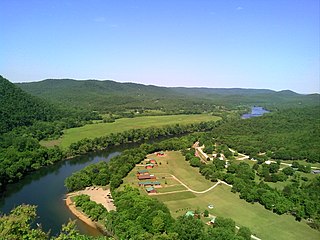
Wood Mountain Regional Park is a conservation and recreation area in its natural state set aside as a regional park in the south-western region of the Canadian province of Saskatchewan. The park is set in the semi-arid Palliser's Triangle in an upland area called Wood Mountain Hills. It is in the Rural Municipality of Old Post No. 43, 8 kilometres (5.0 mi) south of the village of Wood Mountain along Highway 18.

The Hudson Highlands are mountains on both sides of the Hudson River in New York state lying primarily in Putnam County on its east bank and Orange County on its west. They continue somewhat to the south in Westchester County and Rockland County, respectively. The highlands are a subrange of the Appalachian Mountains.

Aldie is an unincorporated community and census-designated place (CDP) located between Chantilly and Middleburg in Loudoun County, Virginia, United States. The historic village of Aldie is located on the John Mosby Highway in a gap between the Catoctin Mountains and Bull Run Mountains, through which the Little River flows. Aldie traditionally serves as the gateway to the Loudoun Valley and beyond.
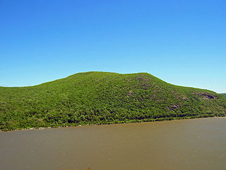
Bull Hill, also known as Mount Taurus, is a mountain north of the village of Cold Spring on the Hudson River in Putnam County in the State of New York. It is part of the river-straddling range known as the Hudson Highlands. The original name came after a bull that used to terrorize the mountain was chased by indignant inhabitants. A hunting party drove the bull over the hill. In an attempt to flee the mountaineers, the bull plunged out into space and fell down. Its broken and shapeless mass on the rocks was memorialized in the name of the mountain the bull used to haunt.

The Bull of the Woods Wilderness is a wilderness area located in the Mount Hood National Forest in the northwestern Cascades of Oregon, United States. It was created in 1984 and consists of 37,607 acres (15,219 ha) including prime low-elevation old-growth forest, about a dozen lakes of at least 1-acre (4,000 m2) and many large creeks and streams. Adjacent areas, including Opal Creek Wilderness to the west, create a pristine area of nearly 84 square miles (218 km2). There are seven trails that access the wilderness area with an additional seven trails within the protection boundaries themselves. Combined the system provides 75 miles (121 km) of challenging terrain for both pedestrian and equestrian recreation. The name of the peak and thus the wilderness area comes from logging jargon in which the "bull of the woods" was the most experienced logging foreman in an operation.

Mountain Lakes is a commuter railroad station in the borough of Mountain Lakes, Morris County, New Jersey, United States. The station is on New Jersey Transit's Montclair-Boonton Line, the last before the line merges with the Morristown Line at Denville station to the west. The station has one low-level side platform, serving a solo track. The 1912-built William Hull Botsford station depot stands on the single platform, along with an ornate station shelter. The next station to the east of Mountain Lakes is Boonton.

Bull Mountain is an unincorporated community and census-designated place in Washington County, Oregon, United States. Bull Mountain is located mostly on a hill for which the community is named. It is bordered on the east by Tigard, on the south by King City, and Beaverton lies to the north. The northeastern part of the Bull Mountain hill is now within the Tigard city limits, as the city has steadily annexed portions of the unincorporated region on its boundary. In 2010, the community became a census-designated place with a population of 9,133. Fire protection and EMS services are provided through Tualatin Valley Fire and Rescue.

Mount Toby, 1,269 feet (387 m), is the highest summit of a sprawling collection of mostly wooded hills and knolls that rise from a distinct plateau-like upland in the towns of Sunderland and Leverett, Massachusetts, just east of the Connecticut River. This mountain mass, part of the Metacomet Ridge geology, is oval shaped and roughly three miles by two miles wide. Although three of the subordinate peaks have names of their own, none of them are noteworthy on their own, and the designation “Mount Toby” is most often used to describe the entire geologic mass. This article, therefore, describes the entire Mount Toby upland.

The Black Hills is an isolated mountain range rising from the Great Plains of North America in western South Dakota and extending into Wyoming, United States. Black Elk Peak, which rises to 7,242 feet (2,207 m), is the range's highest summit. The name of the range in Lakota is Pahá Sápa. It encompasses the Black Hills National Forest. It formed as a result of an upwarping of ancient rock, after which the removal of the higher portions of the mountain mass by stream erosion produced the present-day topography. The hills are so called because of their dark appearance from a distance, as they are covered in evergreen trees.
The Wood Mountain First Nation is a Lakota First Nations band government in southern Saskatchewan, Canada. Led across the border by Sitting Bull, they are the only organized Lakota nation in Canada. Their reserve is located at Wood Mountain 160, near Grasslands National Park, although most members reside elsewhere.
Red Hill is a mountain located in the Catskill Mountains of New York east-south of Frost Valley. Woodhull Mountain is located northeast of Red Hill.
Stevens Mountain is a mountain located in the Catskill Mountains of New York southeast of Gilboa. Reed Hill is located north-northwest, Bull Hill is located northeast, and Mount Royal is located south of Sicklers Mountain.

Wood Mountain Post Provincial Park is a 5.48-hectare historical provincial park in the Canadian province of Saskatchewan. The site was designated as an historic site in the 1960s and became a provincial park in 1986. Originally, it was the location of a North-West Mounted Police (NWMP) post that operated from 1887 to 1918. The post was established to develop relations with local Indians, patrol the Canada–United States border, and to perform general policing duties.

