
Portland Head Light is a historic lighthouse in Cape Elizabeth, Maine. The light station sits on a head of land at the entrance of the primary shipping channel into Portland Harbor, which is within Casco Bay in the Gulf of Maine. Completed in 1791, it is the oldest lighthouse in Maine. The light station is automated, and the tower, beacon, and foghorn are maintained by the United States Coast Guard, while the former lighthouse keepers' house is a maritime museum within Fort Williams Park.

Spring Point Ledge Light is a sparkplug lighthouse in South Portland, Maine, that marks a dangerous obstruction on the west side of the main shipping channel into Portland Harbor. It is now adjacent to the campus of Southern Maine Community College.

Point Iroquois Light is a lighthouse on a Chippewa County bluff in the U.S. state of Michigan. Point Iroquois and its light mark the division line between Whitefish Bay and the western end of the St. Marys River, the connection between Lake Superior and other Great Lakes.

Chatham Lighthouse, known as Twin Lights prior to 1923, is a lighthouse in Chatham, Massachusetts, near the "elbow" of Cape Cod. The original station, close to the shore, was built in 1808 with two wooden towers, which were both replaced in 1841. In 1877, two new towers, made of cast iron rings, replaced those. One of the towers was moved to the Eastham area, where it became known as Nauset Light in 1923.
Halfway Rock Lighthouse is a lighthouse located on a barren ledge in Casco Bay, Maine. The lighthouse tower, which has a height of 76 feet (23 m), and the attached ex-boathouse are all that remains, as the other buildings have been taken away in storms. The name "Halfway Rock" comes from the position of the rock which is halfway between Cape Elizabeth and Cape Small, the southwest and northeast extremities of Casco Bay, which are about 18 nautical miles (33 km) apart.

The Pemaquid Point Light is a historic U.S. lighthouse located in Bristol, Lincoln County, Maine, at the tip of the Pemaquid Neck.

Nobska Light, originally called Nobsque Light, also known as Nobska Point Light is a lighthouse located near the division between Buzzards Bay, Nantucket Sound, and Vineyard Sound in the settlement of Woods Hole, Massachusetts on the southwestern tip of Cape Cod, Massachusetts. It overlooks Martha's Vineyard and Nonamesset Island. The light station was established in 1826, with the tower protruding above the keeper's house, and was replaced in 1876 by the current 42 foot tall iron tower. The light station was added to the National Register of Historic Places as Nobska Point Light Station in 1987.

The Cape Neddick Light is a lighthouse in Cape Neddick, York, Maine. In 1874 Congress appropriated $15,000 to build a light station at the "Nubble" and in 1879 construction began. Cape Neddick Light Station was dedicated by the U.S. Lighthouse Service and put into use in 1879. It is still in use today.

Ram Island Ledge Light is a lighthouse in Casco Bay, Maine, United States, marking the northern end of the main channel leading the harbor of Portland, Maine.

Boon Island Light is located on the 300-by-700-foot Boon Island off the southern coast of Maine, United States, near Cape Neddick. Boon Island Light has the distinction of being the tallest lighthouse in both Maine and New England at 133 feet (41 m). The lighthouse has a focal plane at 137 feet (42 m) above mean high water. The light's beacon flashes white every 5 seconds.

Goat Island Light is a lighthouse located off Cape Porpoise near Kennebunkport in southern Maine. Goat Island Light was established in 1835 to guard the entrance to Cape Porpoise Harbor. The original station was upgraded in 1859 to the current brick tower with a fifth order Fresnel lens. Keeper's quarters were added to the island in 1860. The light station was automated by the United States Coast Guard in 1990 and is currently active. The keepers dwellings and tower are leased to the Kennebunkport Conservation Trust. Goat Island Light can be seen from shore in Cape Porpoise Harbor just off State Route 9 north of Kennebunkport or is viewable by boat. The island is currently closed to the public except by special arrangement.
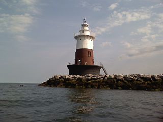
Greens Ledge Light is a historic lighthouse in the western Long Island Sound near Norwalk, Connecticut and Darien, Connecticut. It is one of 33 sparkplug lighthouses still in existence in the United States and remains an active aid to navigation. It sits in ten feet of water on the west end of Greens Ledge, a shallow underwater reef that runs a mile west of Sheffield Island and is roughly a mile south of the entrance to Five Mile River at Rowayton. Completed in 1902 by the Philadelphia Construction Company, the cast-iron structure is approximately 90 feet tall including roughly 15 feet of the submerged caisson. In 1933, more than 30,000 tons of rocks from the excavation of Radio City Music Hall were added to the riprap foundation. The light was added to the National Register of Historic Places as Greens Ledge Lighthouse on May 29, 1990.

Race Point Light is a historic lighthouse on Cape Cod, in Provincetown, Massachusetts; it is on the National Register of Historic Places. The original tower, first illuminated in 1816, was replaced in 1876 with the current 45-foot tall iron-plated tower and a new keeper's dwelling. The American Lighthouse Foundation operates the property and rents out two buildings for overnight stays. The actual light is maintained by the Coast Guard. The site is reached by walking about 45 minutes over sand; with a National Park Service Oversand Permit, a four-wheel-drive vehicle can be used.

The Manitou Island Light Station is a lighthouse located on Manitou Island, off the tip of Michigan's Keweenaw Peninsula in Lake Superior. It was listed on the National Register of Historic Places in 1984.

The Fort Point Light, or Fort Point Light Station, is located in Fort Point State Park, in Stockton Springs, Maine. A lighthouse at this point has served as an active aid to navigation since 1835; the present lighthouse dates to 1857, and is listed on the National Register of Historic Places.

The Tarpaulin Cove Light is a historic lighthouse on Naushon Island, one of the Elizabeth Islands of southern Massachusetts. It is located in the town of Gosnold, Massachusetts. Built on the site of a light station first established privately in the 18th century, the current tower dates from 1891. A keeper's house built at the same time has not survived. The light is 78 feet (24 m) above Mean High Water, and its white light is visible for 9 nautical miles.

Marshall Point Light Station is a lighthouse at the entrance of Port Clyde Harbor in Port Clyde, Maine. The light station was established in 1832.

The Cuckolds Light, known as the Cuckolds Island Fog Signal and Light Station or just Cuckolds Light Station, is a lighthouse located on the eastern pair of islets known as the "Cuckolds" in Lincoln County, Maine. The islets are southeast and in sight of Cape Island, that is just off the southern tip of Cape Newagen on Southport Island, south of Booth Bay, that leads to Boothbay Harbor, Maine.

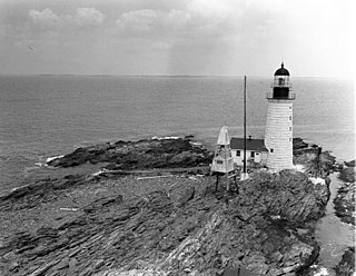
Heron Neck Light is a lighthouse on Green's Island in Vinalhaven, Maine at the south end of Penobscot Bay. It was established in 1854 as an aid to navigation for Vinalhaven's main port, and for the Hurricane Channel extending northwest from Heron's Neck. The light was automated in 1984. It was listed on the National Register of Historic Places as Heron Neck Light Station on January 21, 1988.

Petit Manan Light is a lighthouse on Petit Manan Island, Maine. The island is at the end of a series of ledges extending out from Petit Manan Point, between Dyer Bay and Pigeon Hill Bay, that projects into the Gulf of Maine.


