This article is being considered for deletion in accordance with Wikipedia's deletion policy. Please share your thoughts on the matter at this article's deletion discussion page. |
The following is a list of geographical centre points of counties of the United Kingdom. The data has been taken from the Ordnance Survey's "GB Counties - Past and Present" dataset, under an Open Government Licence (OGL). The coordinates were calculated using the centroid function in QGIS.
County | Coordinates | Location |
---|---|---|
Bedfordshire | 52.073082,-0.4516169 | Near Wilstead |
Berkshire | 51.450756,-1.0723208 | Sulham |
Buckinghamshire | 51.834188,-0.7988019 | Near Bierton |
Cambridgeshire | 52.366732,0.0048432556 | Near Colne |
Aberdeenshire | 57.271212,-2.6764614 | Near Alford |
Angus | 56.723809,-2.9172492 | Near Memus, Forfar |
Argyll and Bute | 56.122222,-5.5481961 | Near Slockavullin |
Ayrshire and Arran | 55.450686,-4.6264238 | Chalmers Road, Ayr |
Banffshire | 57.444538,-3.0273224 | A920, Keith |
Cheshire | 53.211217,-2.5328412 | Near Winsford |
Berwickshire | 55.788291,-2.3603951 | Duns Wood, Duns |
Bristol | 51.452797,-2.7707828 | Near Clapton-in-Gordano |
Caithness | 58.429408,-3.465827 | Near Halkirk |
City and County of the City of London | 51.51441,-0.092443446 | 2 Trump Street |
City of Aberdeen | 57.155793,-2.1736486 | 79 Sheddocksley Rd, Aberdeen |
City of Dundee | 56.477198,-2.9695581 | Clepington Road, Dundee |
City of Edinburgh | 55.926555,-3.2886331 | Sighthill Public Park, Edinburgh |
City of Glasgow | 55.85795,-4.2536076 | 131 Argyle Street, Glasgow |
Clackmannan | 56.150462,-3.7422316 | Near Tillicoultry |
Clwyd | 53.114576,-3.4134696 | Near Cyffylliog |
Cornwall | 50.402682,-4.8368381 | Near Roche |
Cumbria | 54.575641,-2.9118693 | Near A592 Madderdale |
Derbyshire | 53.134748,-1.6105754 | Near South Darley |
Devon | 50.750598,-3.8101725 | Near Hittisleigh |
Dorset | 50.802589,-2.3045221 | Near Milton Abbas |
Dumfries | 55.18499,-3.4883186 | Near Nethermill |
Dunbartonshire | 56.037831,-4.4940795 | Near Duncryne |
Durham | 54.676719,-1.76656 | Near Witton-le-Wear |
Dyfed | 51.996471,-4.3390671 | Near Llangeler |
East Lothian | 55.941977,-2.7209362 | Morham, near Haddington |
East Riding of Yorkshire | 53.864429,-0.47789764 | Near Cherry Burton |
East Sussex | 50.936847,0.25696693 | Near Horam |
Essex | 51.784325,0.57447209 | Near Hatfield Peverel |
Fife | 56.229094,-3.1246297 | Near Kirkforthar, Glenrothes |
Gloucestershire | 51.779431,-2.1840679 | Near Painswick, Stroud |
Greater London | 51.500467,-0.10936448 | Greet House, Frazier Street, London |
Greater Manchester | 53.515167,-2.2841841 | Near Prestwich |
Gwent | 51.711111,-2.9746122 | Near Llanbadoc |
Gwynedd | 52.981718,-4.1014662 | Near Coed Oerddwr |
Hampshire | 51.057882,-1.2861195 | Near Chilcomb, Winchester |
Herefordshire | 52.103478,-2.7449719 | Near Portway, Hereford |
Hertfordshire | 51.829664,-0.21738703 | Near Welwyn |
Inverness | 57.037635,-4.7708886 | Near South Laggan |
Isle of Wight | 50.675974,-1.2962148 | Near Newport |
Kent | 51.236852,0.72430285 | Near Lenham, Maidstone |
Kincardineshire | 56.945198,-2.4256644 | Near Mains of Inchbreck |
Lanarkshire | 55.652752,-3.8305195 | Near Hawksland |
Lancashire | 53.842959,-2.6301083 | Near Goosnargh, Preston |
Leicestershire | 52.666565,-1.1142971 | Near Leicester |
Lincolnshire | 53.182984,-0.27772661 | Near Bucknall |
Merseyside | 53.443655,-2.9558565 | Near Lusitania Rd, Anfield, Liverpool L4 6TY |
Mid Glamorgan | 51.632675,-3.4783237 | Near Cwm Clydach |
Midlothian | 55.832218,-3.1104319 | Near Rosewell |
Moray | 57.578219,-3.4056279 | Near Kellas |
Nairn | 57.487038,-3.8483579 | Near Balmore |
Norfolk | 52.675545,0.9461056 | 15 Lynn Ct, Dereham NR19 1SU |
North Yorkshire | 54.197916,-1.3942305 | Near Topcliffe, Thirsk |
Northamptonshire | 52.307466,-0.86579765 | Near Moulton |
Northumberland | 55.241358,-2.0663853 | Near Elsdon |
Nottinghamshire | 53.127175,-1.0126633 | Near Kirklington, Newark |
Orkney | 59.02919,-3.0358488 | Near Wide Firth |
Oxfordshire | 51.765403,-1.3219832 | Near Wytham |
Perth and Kinross | 56.565448,-3.8189619 | Near Scotston, Dunkeld |
Powys | 52.32374,-3.4099285 | Near Abbey Cwmhir |
Renfrewshire | 55.837027,-4.5473421 | Kilbarchan Park, Kilbarchan, Johnstone |
Ross and Cromarty | 57.559456,-5.3334895 | Near Coulin, Achnasheen |
Roxburgh, Ettrick and Lauderdale | 55.494628,-2.7675682 | South of Riddell |
Rutland | 52.66072,-0.65470444 | Armley Wood, Oakham |
Shetland | 60.394926,-1.2540398 | Easter Hill of Dale, Shetland |
Shropshire | 52.642847,-2.7136856 | Berrington, Shrewsbury |
Somerset | 51.149079,-2.8906518 | Chilton Polden, Bridgwater |
South Glamorgan | 51.464264,-3.3382002 | St Nicholas, Cardiff |
South Yorkshire | 53.48447,-1.3314539 | Swinton, Mexborough |
Staffordshire | 52.857181,-2.0367897 | Gaydon, Stafford |
Stirling and Falkirk | 56.213919,-4.2726206 | March Wood, Callander |
Suffolk | 52.219105,1.0628571 | Stonham Earl |
Surrey | 51.247924,-0.42058494 | Near Effingham |
Sutherland | 58.216009,-4.4759361 | Vagastie, Lairg |
The Stewartry of Kirkcudbright | 55.019733,-4.0624932 | Glenlaggan Wood, Castle Douglas |
Tweeddale | 55.622858,-3.289749 | Near Peebles |
Tyne & Wear | 54.954348,-1.5644016 | Gateshead |
Warwickshire | 52.300231,-1.5597289 | Old Milverton, Leamington Spa |
West Glamorgan | 51.661422,-3.8968131 | Llansamlet, Swansea |
West Lothian | 55.884932,-3.5739149 | Seafield, Livingston |
West Midlands | 52.488364,-1.8742328 | Birmingham |
West Sussex | 50.955932,-0.49511761 | Near Pulborough |
West Yorkshire | 53.743097,-1.688899 | Near Gomersal |
Western Isles | 57.907624,-6.8746211 | Loch a' Siar |
Wigtown | 54.920595,-4.6668604 | Kiltersan, Newton Stewart |
Wiltshire | 51.31524,-1.9314378 | Urchfont, Devizes |
Worcestershire | 52.223541,-2.1690516 | Near Hindlip |
Yorkshire | 53.981515, -1.241348 | Near Hessay, near York [1] |
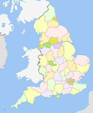
The counties for the purposes of the lieutenancies in England, also referred to as the lieutenancy areas of England and informally known as ceremonial counties, are areas of England to which lords-lieutenant are appointed. Legally, the areas in England, Wales and Scotland are defined by the Lieutenancies Act 1997 as "counties and areas for the purposes of the lieutenancies in Great Britain", in contrast to the metropolitan and non-metropolitan counties of England used for local government. They are also informally known as "geographic counties", to distinguish them from other types of counties of England.
The English Football League Two, simply known as League Two in England and for sponsorship purposes as Sky Bet League Two, is the 3rd and lowest division of the English Football League (EFL) and fourth-highest division overall in the English football league system.
An electoral swing analysis shows the extent of change in voter support, typically from one election to another, expressed as a positive or negative percentage. A multi-party swing is an indicator of a change in the electorate's preference between candidates or parties, often between major parties in a two-party system. A swing can be calculated for the electorate as a whole, for a given electoral district or for a particular demographic.
The location of the geographical centre of Europe depends on the definition of the borders of Europe, mainly whether remote islands are included to define the extreme points of Europe, and on the method of calculating the final result. Thus, several places claim to host this hypothetical centre.
In demographics, the center of population of a region is a geographical point that describes a centerpoint of the region's population. There are several ways of defining such a "center point", leading to different geographical locations; these are often confused.
In the United Kingdom (UK), each of the electoral areas or divisions called constituencies elects one member to the House of Commons.
A super-maximum security (supermax) or administrative maximum (ADX) prison is a "control-unit" prison, or a unit within prisons, which represents the most secure level of custody in the prison systems of certain countries.
The term benchmark, bench mark, or survey benchmark originates from the chiseled horizontal marks that surveyors made in stone structures, into which an angle-iron could be placed to form a "bench" for a leveling rod, thus ensuring that a leveling rod could be accurately repositioned in the same place in the future. These marks were usually indicated with a chiseled arrow below the horizontal line. A benchmark is a type of survey marker.
The United States census of 1850 was the seventh census of the United States. Conducted by the Census Office, it determined the resident population of the United States to be 23,191,876—an increase of 35.9 percent over the 17,069,453 persons enumerated during the 1840 census. The total population included 3,204,313 slaves.
A list of highest points typically contains the name, elevation, and location of the highest point in each of a set of geographical regions. Such a list is important in the sport of highpointing. A partial list of highpoint lists is below:
The National Register of Champion Trees is a list of the largest tree specimens found in the United States as reported to American Forests by the public. A tree on this list is called a National Champion Tree.
Centre Street is a north–south street in the New York City borough of Manhattan, running through the Civic Center, Chinatown (曼哈頓華埠), and Little Italy neighborhoods of Lower Manhattan. It connects Park Row to the south with Spring Street to the north, where it merges with Lafayette Street. Centre Street carries northbound traffic north of Reade Street and two-way traffic between Reade Street and the Brooklyn Bridge.
In geography, the centroid of the two-dimensional shape of a region of the Earth's surface is known as its geographic centre or geographical centre or gravitational centre. Informally, determining the centroid is often described as finding the point upon which the shape would balance. This method is also sometimes described as the "gravitational method".
The City of Leeds is a city and metropolitan borough in West Yorkshire, England. The metropolitan borough includes the administrative centre of Leeds and the towns of Farsley, Garforth, Guiseley, Horsforth, Morley, Otley, Pudsey, Rothwell, Wetherby and Yeadon. It has a population of 811,956 (2021), making it technically the second largest city in England by population behind Birmingham, since London is not a single local government entity. Local governance sits with Leeds City Council and the city's 32 Parish Councils.
Brennand Farm is often claimed to be the true centre of Great Britain. This is about seven kilometres north-west of Dunsop Bridge - which has the nearest BT phone box to the 'true centre'. A plaque reads “You are calling from the BT payphone that marks the centre of Great Britain”.
The 1924 United States presidential election in Virginia took place on November 4, 1924. Voters chose 12 representatives, or electors to the Electoral College, who voted for president and vice president.
The 2016 United States presidential election in Rhode Island took place on November 8, 2016, as part of the 2016 United States presidential election in which all 50 states plus the District of Columbia participated. Rhode Island voters chose four electors to represent them in the Electoral College via a popular vote.
The 2020 United States presidential election in Tennessee was held on Tuesday, November 3, 2020, as part of the 2020 United States presidential election in which all 50 states plus the District of Columbia participated. Tennessee voters chose electors to represent them in the Electoral College via a popular vote, pitting the Republican Party's nominee, incumbent President Donald Trump, and running mate Vice President Mike Pence against Democratic Party nominee, former Vice President Joe Biden, and his running mate California Senator Kamala Harris. Tennessee has 11 electoral votes in the Electoral College.
The 2020 United States presidential election in Utah was held on Tuesday, November 3, 2020, as part of the 2020 United States presidential election in which all 50 states plus the District of Columbia participated. Utah voters chose electors to represent them in the Electoral College via a popular vote, pitting the Republican Party's nominee, incumbent President Donald Trump, and running mate Vice President Mike Pence against Democratic Party nominee, former Vice President Joe Biden, and his running mate California Senator Kamala Harris. Utah has six electoral votes in the Electoral College.