
Chicopee is a city located on the Connecticut River in Hampden County, Massachusetts, United States. As of the 2020 census, the city had a population of 55,560, making it the second-largest city in Western Massachusetts after Springfield. Chicopee is part of the Springfield, Massachusetts Metropolitan Statistical Area. The communities of Chicopee Center (Cabotville), Chicopee Falls, Willimansett, Fairview, Aldenville, Burnett Road, Smith Highlands and Westover are located within the city.

The Connecticut River is the longest river in the New England region of the United States, flowing roughly southward for 406 miles (653 km) through four states. It rises 300 yards south of the U.S. border with Quebec, Canada, and discharges at Long Island Sound. Its watershed encompasses 11,260 square miles (29,200 km2), covering parts of five U.S. states and one Canadian province, via 148 tributaries, 38 of which are major rivers. It produces 70% of Long Island Sound's fresh water, discharging at 18,400 cubic feet (520 m3) per second.

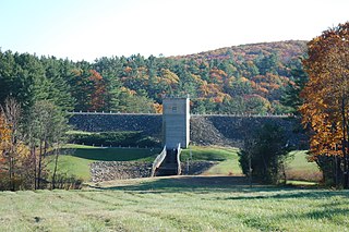
The Quabbin Reservoir is the largest inland body of water in Massachusetts, and was built between 1930 and 1939. Along with the Wachusett Reservoir, it is the primary water supply for Boston, 65 miles (105 km) to the east, and 40 other cities and towns in Greater Boston. The Quabbin also supplies water to three towns west of the reservoir and acts as backup supply for three others. By 1989, it supplied water for 2.5 million people, about 40% of the state's population at the time. It has an aggregate capacity of 412 billion US gallons (1,560 GL) and an area of 38.6 square miles (99.9 km2).

The Farmington River is a river, 46.7 miles (75.2 km) in length along its main stem, located in northwest Connecticut with major tributaries extending into southwest Massachusetts. The longest route of the river, from the origin of its West Branch, is 80.4 miles (129.4 km) long, making it the Connecticut River's longest tributary by 2.3 miles (3.7 km) over the major river directly to its north, the Westfield River. The Farmington River's watershed covers 609 square miles (1,580 km2). Historically, the river played an important role in small-scale manufacturing in towns along its course, but it is now mainly used for recreation and drinking water.
The Pemigewasset River, known locally as "The Pemi", is a river in the state of New Hampshire, the United States. It is 65.0 miles (104.6 km) in length and drains approximately 1,021 square miles (2,644 km2). The name "Pemigewasset" comes from the Abenaki word bemijijoasek [bəmidzidzoasək], meaning "where side (entering) current is".

Sharavati is a river which originates and flows entirely within the state of Karnataka in India. It is one of the few westward flowing rivers of India and a major part of the river basin lies in the Western Ghats. The famous Jog Falls, located about 24 km from Sagara, are formed by this river. The river itself and the region around it are rich in biodiversity and are home to many rare species of flora and fauna.
Interstate 391 (I-391) is an Auxiliary Interstate Highway located entirely within the U.S. State of Massachusetts. It runs from the I-91/I-391 interchange in Chicopee to the center of Holyoke, a distance of about 4.86 mi (7.82 km). It runs near the Connecticut River throughout its journey in Chicopee, and crosses into Holyoke and abruptly ends at High Street 0.4 miles (0.64 km) south of U.S. Route 202.

The Winsor Dam and the Goodnough Dike impound the waters of the Swift River and the Ware River Diversion forming the Quabbin Reservoir, the largest water body in Massachusetts. According to the Massachusetts Department of Conservation and Recreation the Winsor Dam is one of the largest dams in the Eastern U.S. The Winsor Dam is part of the Chicopee River Watershed. The Winsor Dam was named for Frank E. Winsor, its chief engineer.
The Ware River is a 35.4-mile-long (57.0 km) river in central Massachusetts. It has two forks, both of which begin in Hubbardston, Massachusetts. The Ware River flows southwest through the middle of the state, joins the Quaboag River at Three Rivers, Massachusetts, to form the Chicopee River on its way to the Connecticut River.

The Goodnough Dike is on the southeastern end of the Quabbin Reservoir, the largest water body in Massachusetts. It impounds the waters of Beaver Brook and therefore closes that exit to the Chicopee River Watershed. The Goodnough Dike is not as large as the Winsor Dam, but it is equally important as they both trap the waters of the Quabbin Reservoir. This dam is part of the metropolitan Boston's water supply, maintained by the Massachusetts Water Resources Authority.

Lake Lashaway is a 293-acre (1.19 km2) pond located near the East Brookfield and North Brookfield, Massachusetts town line. The Lake Lashaway Community Association’s website is www.LakeLashaway.org. The town line cuts the lake approximately in half. The lake lies just to the north of state Route 9 as it passes through East Brookfield.

Quaboag Pond is a 537-acre (2.17 km2) pond located near the East Brookfield and Brookfield, Massachusetts. The pond lies about two miles (3 km) south of state Route 9 as it passes through East Brookfield. Quaboag Pond was once named Podunk Pond.
The Barre Falls Dam is located on the Ware River in Barre, Massachusetts, about 0.3 mile (0.48 km) below the junction of the river's east and west branches and 13 miles (21 km) northwest of Worcester, Massachusetts.

Brooks Pond is a Massachusetts water body that is privately owned, controlled and managed, and bordered by the towns of North Brookfield, Oakham, Spencer, and New Braintree. It forms the headwaters of the Five Mile River, which is part of the Chicopee River Watershed.

The Sugden Reservoir is a Massachusetts reservoir located in Spencer, Massachusetts. It forms the headwaters of Shaw Brook, which is a tributary to Turkey Hill Creek, a major tributary to the Seven Mile River. This water body is part of the Chicopee River Watershed.

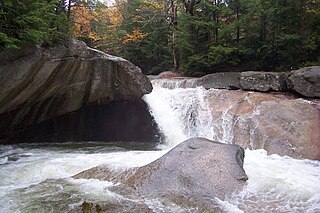
The Chicopee River is an 18.0-mile-long (29.0 km) tributary of the Connecticut River in the Pioneer Valley, Massachusetts, known for fast-moving water and its extraordinarily large basin: the Connecticut River's largest tributary basin. The Chicopee River originates in a Palmer, Massachusetts village called Three Rivers as a confluence of the Ware, Quaboag and Swift rivers. It passes through Wilbraham, Ludlow, and the Indian Orchard neighborhood of Springfield.

The Conant Brook Dam is located on Conant Brook in Monson, Massachusetts, about 7.4 miles (11.9 km) upstream from the confluence of Conant Brook and the Quaboag River. It is approximately 15 miles (24 km) east of Springfield, Massachusetts.
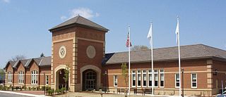
The Chicopee Public Library is the public library for the city of Chicopee, Massachusetts. A member of the Western Massachusetts Regional Library System (WMRLS), the library participates in resources sharing and collaboration with all other libraries in the WRMLS. The library owns approximately 109,000 books according to the 2005 IMLS Public Library Report. In addition, they have 4,200 media items and send and receive over 35,000 interlibrary loan requests. In the fiscal year 2008, the city of Chicopee spent 1.1% of its budget ($1,401,141) on its public library, around $25 per person.


