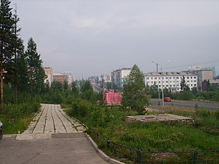
Neryungri is the second largest town in the Sakha Republic, Russia and the administrative center of Neryungrinsky District. As of the 2010 Census, its population was 61,747.

Chersky is an urban locality and the administrative center of Nizhnekolymsky District of the Sakha Republic, Russia, located on the Kolyma River, 1,920 kilometers (1,190 mi) east from Yakutsk, the capital of the republic. As of the 2010 Census, its population was 2,857.

Churapchinsky District is an administrative and municipal district, one of the thirty-four in the Sakha Republic, Russia. It is located in the center of the republic and borders Tattinsky District in the north, Ust-Maysky District in the east and southeast, Amginsky District in the south, Megino-Kangalassky District in the west, and Ust-Aldansky District in the northwest. The area of the district is 12,600 square kilometers (4,900 sq mi). Its administrative center is the rural locality of Churapcha. As of the 2010 Census, the total population of the district was 20,387, with the population of Churapcha accounting for 43.0% of that number.

Nizhnekolymsky District is an administrative and municipal district, one of the thirty-four in the Sakha Republic, Russia. It is located in the northeast of the republic and borders with Allaikhovsky District in the west, Srednekolymsky District in the south, and with Bilibinsky District of Chukotka Autonomous Okrug in the east. The area of the district is 87,100 square kilometers (33,600 sq mi). Its administrative center is the urban locality of Chersky. Population: 4,664 (2010 Census); 5,932 ; 13,692 (1989 Soviet census). The population of Chersky accounts for 61.3% of the district's total population.

Amginsky District is an administrative and municipal district, one of the thirty-four in the Sakha Republic, Russia. It is located in the southeast of the republic and borders with Churapchinsky District in the north, Ust-Maysky District in the east and southeast, Aldansky District in the south and southwest, and with Khangalassky and Megino-Kangalassky Districts in the northwest. The area of the district is 29,400 square kilometers (11,400 sq mi). Its administrative center is the rural locality of Amga. As of the 2010 Census, the total population of the district was 17,183, with the population of Amga accounting for 38.0% of that number.

Bulunsky District is an administrative and municipal district, one of the thirty-four in the Sakha Republic, Russia. It is located in the north of the republic and borders Ust-Yansky District in the east, Verkhoyansky District in the southeast, Eveno-Bytantaysky and Zhigansky Districts in the south, Olenyoksky District in the west, and Anabarsky District in the northwest. The area of the district is 223,600 square kilometers (86,300 sq mi). Its administrative center is the urban-type settlement of Tiksi. As of the 2010 Census, the total population of the district was 9,054, with the population of Tiksi accounting for 55.9% of that number.

Momsky District is an administrative and municipal district, one of the thirty-four in the Sakha Republic, Russia. It is located in the northeast of the republic. The area of the district is 104,600 square kilometers (40,400 sq mi). Its administrative center is the rural locality of Khonuu. As of the 2010 Census, the total population of the district was 4,452, with the population of Khonuu accounting for 55.6% of that number.

Olyokminsky District is an administrative and municipal district, one of the thirty-four in the Sakha Republic, Russia. It is located in the southwest of the republic and borders with Verkhnevilyuysky District in the north, Gorny and Khangalassky Districts in the northeast, Aldansky District in the east, Neryungrinsky District in the southeast, Zabaykalsky Krai in the southwest, Irkutsk Oblast and Lensky District in the west, and with Suntarsky District in the northwest. The area of the district is 160,800 square kilometers (62,100 sq mi). Its administrative center is the town of Olyokminsk. Population: 26,785 (2010 Census); 27,563 ; 30,938 (1989 Soviet census). The population of Olyokminsk accounts for 35.4% of the district's total population.

Neryungrinsky District is an administrative and municipal district, one of the thirty-four in the Sakha Republic, Russia. It is the southernmost district of Sakha and borders Aldansky District in the north, Olyokminsky District in the west and south, Amur Oblast and a small area of Zabaykalsky Krai in the west, and Khabarovsk Krai in the east. The area of the district is 98,900 square kilometers (38,200 sq mi). Its administrative center is the town of Neryungri. Population : 21,019 (2010 Census).

Berkakit is an urban locality in Neryungrinsky District of the Sakha Republic, Russia, located 7 kilometers (4.3 mi) from Neryungri, the administrative center of the district. As of the 2010 Census, its population was 4,291.

Khani is an urban locality in Neryungrinsky District of the Sakha Republic, Russia, located 405 kilometers (252 mi) from Neryungri, the administrative center of the district, in close proximity to the borders with Amur Oblast and Zabaykalsky Krai. As of the 2010 Census, its population was 764.
Zolotinka is an urban locality in Neryungrinsky District of the Sakha Republic, Russia, located 73 kilometers (45 mi) from Neryungri, the administrative center of the district, in the southern reaches of the Aldan Highlands, on the Kholodnikan River, close to where it flows into the Iyengra, a tributary of the Timpton. As of the 2010 Census, its population was 552.
Iyengra is a rural locality, the only inhabited locality, and the administrative center of Iyengrinsky Rural Okrug of Neryungrinsky District in the Sakha Republic, Russia, located on the Iyengra River, 65 kilometers (40 mi) from Neryungri, the administrative center of the district. Its population as of the 2010 Census was 1,104, down from 1,216 recorded during the 2002 Census.
Bolshoy Khatymi is a rural locality, one of two settlements, in addition to Chulman, in Chulman Urban Okrug of Neryungrinsky District in the Sakha Republic, Russia. It is located 99 kilometers (62 mi) from Neryungri, the administrative center of the district. Its population as of the 2010 Census was 311, of whom 156 were male and 155 female, down from 506 as recorded during the 2002 Census.
Orto-Surt is a rural locality, the only inhabited locality, and the administrative center of Maganinsky Rural Okrug of Gorny District in the Sakha Republic, Russia, located 128 kilometers (80 mi) from Berdigestyakh, the administrative center of the district. Its population as of the 2010 Census was 536, up from 516 as recorded during the 2002 Census.
Maymaga is a rural locality in Khatyryksky Rural Okrug of Namsky District in the Sakha Republic, Russia, located 42 kilometers (26 mi) from Namtsy, the administrative center of the district. Its population as of the 2010 Census was 157, up from 152 recorded during the 2002 Census.
Sardanga is a rural locality, the only inhabited locality, and the administrative center of Bordonsky Rural Okrug of Suntarsky District in the Sakha Republic, Russia, located 42 kilometers (26 mi) from Suntar, the administrative center of the district. The locality lies along the left bank of the Vilyuy River. Its population as of the 2010 Census was 904, down from 1,002 recorded during the 2002 Census.
Ilimnir is a rural locality, the only inhabited locality, and the administrative center of Ilimnirsky Rural Okrug of Suntarsky District in the Sakha Republic, Russia, located 22 kilometers (14 mi) from Suntar, the administrative center of the district. Its population as of the 2010 Census was 250, up from 245 recorded during the 2002 Census.
Kyukey is a rural locality, the only inhabited locality, and the administrative center of Kyukyaisky Rural Okrug of Suntarsky District in the Sakha Republic, Russia, located 88 kilometers (55 mi) from Suntar, the administrative center of the district. Its population as of the 2010 Census was 394, up from 345 recorded during the 2002 Census.
Chyappara is a rural locality, the only inhabited locality, and the administrative center of Alagarsky Rural Okrug of Churapchinsky District in the Sakha Republic, Russia, located 89 kilometers (55 mi) from Churapcha, the administrative center of the district. Its population as of the 2010 Census was 728, down from 770 as recorded during the 2002 Census.


