
The Mohawk River is a 149-mile-long (240 km) river in the U.S. state of New York. It is the largest tributary of the Hudson River. The Mohawk flows into the Hudson in Cohoes, New York, a few miles north of the city of Albany. The river is named for the Mohawk Nation of the Iroquois Confederacy. It is a major waterway in north-central New York.

The Chenango River is a 90-mile-long (140 km) tributary of the Susquehanna River in central New York in the United States. It drains a dissected plateau area in upstate New York at the northern end of the Susquehanna watershed.

The Walloomsac River from the Native American name, Wal-loom-sac is a 16.8-mile-long (27.0 km) tributary of the Hoosic River in the northeastern United States. It rises in southwestern Vermont, in the Green Mountains east of the town of Bennington in Woodford Hollow at the confluence of Bolles Brook and City Stream where it is labeled Walloomsac Brook on maps but is locally known as "The Roaring Branch". The river then flows west toward Bennington and passes the downtown area to the north. For many years this section was intermittent due to the water having been diverted to power mills in town. This divergence gave the name Walloomsac to a portion of the river flowing through town on the present course of South Stream. The combined Walloomsac / South Stream joins the Roaring Branch northwest of town. From here the river flows westward as the Walloomsac River and joins the Hoosic River below Hoosick Falls, New York.

The Hackensack River is a river, approximately 45 miles (72 km) long, in the U.S. states of New York and New Jersey, emptying into Newark Bay, a back chamber of New York Harbor. The watershed of the river includes part of the suburban area outside New York City just west of the lower Hudson River, which it roughly parallels, separated from it by the New Jersey Palisades. It also flows through and drains the New Jersey Meadowlands. The lower river, which is navigable as far as the city of Hackensack, is heavily industrialized and forms a commercial extension of Newark Bay. Once believed to be among the most polluted water courses in the United States, it had staged a modest revival by the late 2000s.

The West Branch Delaware River is one of two branches that form the Delaware River. It is approximately 90 mi (144 km) long, and flows through the U.S. states of New York and Pennsylvania. It winds through a mountainous area of New York in the western Catskill Mountains for most of its course, before joining the East Branch along the northeast border of Pennsylvania with New York. Midway or so it is empounded by the Cannonsville Dam to form the Cannonsville Reservoir, both part of the New York City water supply system for delivering drinking water to the City.

Schoharie Creek in New York, flows north 93 miles (150 km) from the foot of Indian Head Mountain in the Catskills through the Schoharie Valley to the Mohawk River. It is twice impounded north of Prattsville to create New York City's Schoharie Reservoir and the Blenheim-Gilboa Power Project.

Lemon Creek is a stream located on the South Shore of Staten Island, one of the five boroughs of New York City. It is one of the few remaining ground-level creeks in New York City.
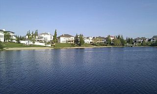
Twin Brooks is a residential neighbourhood in south Edmonton, Alberta, Canada. It is located at the confluence of the Whitemud Creek and the Blackmud Creek, hence the origin of the name Twin Brooks. An artificial lake is situated in the neighbourhood, with George P. Nicholson Elementary School located near it.

The Kedron Brook is an urban creek that flows through the northern suburbs of Brisbane in the South East region of Queensland, Australia.

Peekamoose Mountain is a mountain located in Ulster County, New York. The mountain is part of the Catskill Mountains. Peekamoose Mountain is flanked to the north by Table Mountain. The name Peekamoose is possibly a corruption of an Algonquin word meaning 'broken off smooth', cf. Poke-O-Moonshine Mountain.

Table Mountain is located in Ulster County, New York. The mountain is part of the Catskill Mountains. Table Mountain is flanked to the south by Peekamoose Mountain, and to the northeast by Lone Mountain.

Wittenberg Mountain, locally "the Wittenberg," is a mountain located in Ulster County, New York. The mountain is part of the Burroughs Range of the Catskill Mountains. Wittenberg is flanked to the southwest by Cornell Mountain and to the northeast by Terrace Mountain.

Kinderhook Creek is a 49.0-mile-long (78.9 km) tributary to Stockport Creek, an inlet of the Hudson River in the United States. From its source in Hancock, Massachusetts, the creek runs southwest through the Taconic Mountains into Rensselaer County, New York, and then into Columbia County. It flows through the towns of Stephentown, New Lebanon, Nassau, Chatham, Kinderhook and Stuyvesant to its mouth at Stockport Creek in the town of Stockport.
Mill Creek, also previously known as Tierken Kill, is a tributary to the Hudson River. Poetanock was the Native American name for the stream. From its source just west of Snyders Lake in East Greenbush the stream travels southwest, then north and west to the Hudson River. The stream has two waterfalls, the Upper Falls on the Mill Brook, and the Lower Falls on the Mill Brook. Its mouth on the Hudson River is directly opposite Albany New York at what was Van Rensselaer Island, in the City of Rensselaer.

Kaskitayo is a residential area in the southwest portion of the City of Edmonton in Alberta, Canada. It was established in 1973 through Edmonton City Council's adoption of the Kaskitayo Outline Plan, which guides the overall development of the area.

