
The Lewis and Clark Expedition, also known as the Corps of Discovery Expedition, was the United States expedition to cross the newly acquired western portion of the country after the Louisiana Purchase. The Corps of Discovery was a select group of U.S. Army and civilian volunteers under the command of Captain Meriwether Lewis and his close friend Second Lieutenant William Clark. Clark, along with 30 others, set out from Camp Dubois, Illinois, on May 14, 1804, met Lewis and ten other members of the group in St. Charles, Missouri, then went up the Missouri River. The expedition crossed the Continental Divide of the Americas near the Lemhi Pass, eventually coming to the Columbia River, and the Pacific Ocean in 1805. The return voyage began on March 23, 1806, at Fort Clatsop, Oregon, ending six months later on September 23 of that year.

Clark County is a county located in the southeastern part of U.S. state of Illinois, along the Indiana state line. As of the 2020 census, the population was 15,455. Its county seat is Marshall. The county was named for George Rogers Clark, an officer who served in the American Revolution.

Lincoln County is a county located in the east central portion of the U.S. state of Georgia. As of the 2020 census, the population was 7,690. The county seat is Lincolnton. The county was created on February 20, 1796. Lincoln County is included in the Augusta-Richmond County, GA-SC metropolitan statistical area, the Savannah River forming its northeastern border. Located above the fall line, it is part of the Central Savannah River Area (CSRA) and a member of the CSRA Regional Development Center.

Kirkland is a town in Oneida County, New York, United States. The population was 10,075 at the 2020 census. The town is named after Samuel Kirkland, a missionary among the Oneidas.

Western is a town in Oneida County, New York, United States. The population was 1,951 at the 2010 census.
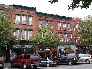
Cooperstown is a village in and the county seat of Otsego County, New York, United States. Most of the village lies within the town of Otsego, but some of the eastern part is in the town of Middlefield. Located at the foot of Otsego Lake in the Central New York Region, Cooperstown is approximately 60 miles west of Albany, 67 mi (108 km) southeast of Syracuse and 145 mi (233 km) northwest of New York City. The population of the village was 1,794 as of the 2020 census.
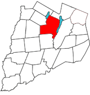
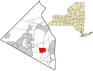
Otsego is a town in the north-central part of Otsego County, New York, United States. The population was 3,641 at the 2020 census. The town is named after Lake Otsego, which forms part of the town's eastern border.
West Nyack is a hamlet and census-designated place in the town of Clarkstown, Rockland County, New York, United States. It is located north of Blauvelt, east of Nanuet, southwest of Valley Cottage, southeast of Bardonia, and west of Central Nyack. It is approximately 18 miles (29 km) north of New York City. The population was 3,439 at the 2010 census.
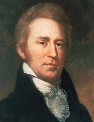
William Clark was an American explorer, soldier, Indian agent, and territorial governor. A native of Virginia, he grew up in pre-statehood Kentucky before later settling in what became the state of Missouri.

Camillus is a town in Onondaga County, New York, United States. As of the 2020 Census, the population was 25,346.

Canandaigua is a city in Ontario County, New York, United States. Its population was 10,576 at the 2020 census. It is the county seat of Ontario County; some administrative offices are at the county complex in the adjacent town of Hopewell.

Clark Air Base is a Philippine Air Force base in Luzon, located 3 miles (4.8 km) west of Angeles City, and about 40 miles (64 km) northwest of Metro Manila. Clark Air Base was previously a United States military facility, operated by the U.S. Air Force under the aegis of Pacific Air Forces (PACAF) and their predecessor organizations from 1903 to 1991. The base covered 14.3 square miles (37 km2) with a military reservation extending north that covered another 230 square miles (600 km2).

The Berkshires are highlands located in western Massachusetts and northwestern Connecticut in the United States. Generally, "Berkshires" may refer to the range of hills in Massachusetts that lie between the Housatonic and Connecticut Rivers. Highlands of northwest Connecticut may be seen as part of the Berkshires and sometimes called the Northwest Hills or Litchfield Hills. The segment of the Taconic Mountains in Massachusetts is often considered a part of the Berkshires, although they are geologically separate and are a comparatively narrow range along New York's eastern border.

Victoria Land is a region in eastern Antarctica which fronts the western side of the Ross Sea and the Ross Ice Shelf, extending southward from about 70°30'S to 78°00'S, and westward from the Ross Sea to the edge of the Antarctic Plateau. It was discovered by Captain James Clark Ross in January 1841 and named after Queen Victoria. The rocky promontory of Minna Bluff is often regarded as the southernmost point of Victoria Land, and separates the Scott Coast to the north from the Hillary Coast of the Ross Dependency to the south.

Augustus Hall, a lawyer, was a one-term Democratic U.S. Representative from Iowa's 1st congressional district, and chief justice of the Nebraska Territory.

Ski country is the hilly, snowy portions of the boundary between the Niagara Frontier and the Southern Tier of the western part of New York.

Berlin Mountain is a 2,818-foot-tall (859 m) prominent peak in the Taconic Mountains of western New England and is located adjacent to Massachusetts's border with New York State. It is the highest point in Rensselaer County. The summit and west side of the mountain are located in New York; the east side lies within Williamstown, Massachusetts. The mountain is a bald, notable for its grassy summit and expansive views of the Hudson River Valley to the west. The 37-mile (60 km) Taconic Crest Trail traverses the mountain. Several other hiking trails approach the summit from the east. Much of the upper slopes and summit are within protected conservation land. Historically the lower slopes of the mountain were farmed heavily throughout the 19th Century. In addition to agriculture, there are several remnants of charcoal kilns located on the mountain that produced fuel for iron smelting.

The 1890–91 United States Senate elections were held on various dates in various states. As these U.S. Senate elections were prior to the ratification of the Seventeenth Amendment in 1913, senators were chosen by state legislatures. Senators were elected over a wide range of time throughout 1890 and 1891, and a seat may have been filled months late or remained vacant due to legislative deadlock. In these elections, terms were up for the senators in Class 3.
Alma Hill is a 2,543-foot-tall (775 m) mountain in the Southern Tier of New York. It is located southwest of Wellsville in Allegany County. In 1950, an 80-foot-tall (24 m) steel fire lookout tower was built on the mountain. Due to the increased use of aerial detection, the tower ceased fire lookout operations at the end of the 1971 fire lookout season. In 1973, the tower was sold to the landowner where the tower stood. It is the highest hill in western New York, or the highest in New York outside the Adirondacks and Catskills.

