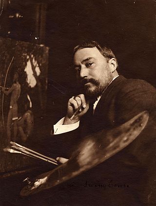
Eanger Irving Couse was an American artist and a founding member and first president of the Taos Society of Artists. Born and reared in Saginaw, Michigan, he went to New York City and Paris to study art. While spending summers in Taos, New Mexico, he began to make the paintings of Native Americans, New Mexico, and the American Southwest for which he is best known. He later settled full time in Taos.

East Greenbush is a town in Rensselaer County, New York, United States. It is a suburb of Albany. The population was 16,748 at the 2020 census. The word Greenbush is derived from the Dutch het groen bosch, referring to the pine woods that originally covered the land. The first settlement of the land now known as East Greenbush was made by tenants under patroon Kiliaen van Rensselaer circa 1630. The town was established in 1855 as Clinton, and was renamed in 1858. It is mostly suburban along its major highways and rural in the southwestern and northeastern corners.

Black Hills National Forest is located in southwestern South Dakota and northeastern Wyoming, United States. The forest has an area of over 1.25 million acres (5,066 km2) and is managed by the Forest Service. Forest headquarters are located in Custer, South Dakota. There are local ranger district offices in Custer, Rapid City, and Spearfish in South Dakota, and in Sundance, Wyoming.

Joseph Henry Sharp was an American painter and a founding member of the Taos Society of Artists, of which he is considered the "Spiritual Father". Sharp was one of the earliest European-American artists to visit Taos, New Mexico, which he saw in 1893 with artist John Hauser. He painted American Indian portraits and cultural life, as well as Western landscapes. President Theodore Roosevelt commissioned him to paint the portraits of 200 Native American warriors who survived the Battle of the Little Bighorn. While working on this project, Sharp lived on land of the Crow Agency, Montana, where he built Absarokee Hut in 1905. Boosted by his sale of 80 paintings to Phoebe Hearst, Sharp quit teaching and began to paint full-time.

Berlin Mountain is a 2,818-foot-tall (859 m) prominent peak in the Taconic Mountains of western New England and is located adjacent to Massachusetts's border with New York State. It is the highest point in Rensselaer County. The summit and west side of the mountain are located in New York; the east side lies within Williamstown, Massachusetts. The mountain is a bald, notable for its grassy summit and expansive views of the Hudson River Valley to the west. The 37-mile (60 km) Taconic Crest Trail traverses the mountain. Several other hiking trails approach the summit from the east. Much of the upper slopes and summit are within protected conservation land. Historically the lower slopes of the mountain were farmed heavily throughout the 19th Century. In addition to agriculture, there are several remnants of charcoal kilns located on the mountain that produced fuel for iron smelting.

The Black Hills is an isolated mountain range rising from the Great Plains of North America in western South Dakota and extending into Wyoming, United States. Black Elk Peak, which rises to 7,242 feet (2,207 m), is the range's highest summit. The name of the range in Lakota is Pahá Sápa. It encompasses the Black Hills National Forest. It formed as a result of an upwarping of ancient rock, after which the removal of the higher portions of the mountain mass by stream erosion produced the present-day topography. The hills are so called because of their dark appearance from a distance, as they are covered in evergreen trees.
The Taos Society of Artists was an organization of visual arts founded in Taos, New Mexico. Established in 1915, it was disbanded in 1927. The Society was essentially a commercial cooperative, as opposed to a stylistic collective, and its foundation contributed to the development of the tiny Taos art colony into an international art center.

McCauley Mountain is a summit and ski resort in the Town of Webb, Herkimer County, New York. It is located just outside the hamlet of Old Forge, in the south-western area of the Adirondack Mountains.

Rum Hill is a mountain located in Central New York Region of New York northwest of the Hamlet of Pierstown. Red House Hill is located southeast, Metcalf Hill is located south, Allen Lake and Mohegan Hill are located north-northwest and Otsego Lake is located east of Rum Hill.
Red House Hill is a mountain in the Central New York Region of the State of New York, United States. It is located south-southwest of the Hamlet of Springfield Center, New York, west of Hutter Point and Six Mile Point of Otsego Lake, and southeast of Rum Hill. Mohican Brook flows eastward along the southern edge of the hill.
Klock Hill is a mountain located in Central New York region of New York southwest of Burlington, New York.
Dairy Hill is a 1,844-foot-tall (562 m) summit located in Central New York Region of New York located in the Town of Norway in Herkimer County, southeast of Norway. The mountain is the former location of a 79-foot-6-inch-tall (24.23 m) steel fire lookout tower.
Frost Hill is a mountain in the Finger Lakes Region of New York. It is located west of Bristol Springs in Ontario County. At an elevation of 2,284 feet (696 m), the mountain is the highest point in Ontario County. It is about 1.25 miles (2.01 km) southwest of the 2,150-foot (660 m) Worden Hill, where Bristol Mountain Ski Resort is.
Bullock Hill is a mountain located in the Catskill Mountains of New York state, west-northwest of Walton. Walton Mountain is located east-southeast of Bullock Hill, Carroll Hill is located west-southwest of it, Couse Hill is located to the north, and Loomis Mountain is located northeast of Bullock Hill.
Red Hill is a mountain located in the Catskill Mountains of New York east-south of Frost Valley. Woodhull Mountain is located northeast of Red Hill.
Morgan Hill is a mountain in the central part of the state of New York. It is located north-northeast of Truxton in Cortland County with a small portion in Onondaga County. The portion of the mountain within Onondaga County is the highest point in the county.
Gallis Hill is a 794-foot-tall (242 m) mountain in the Catskill Mountains region of New York. It is located northwest of Kingston in Ulster County. Jockey Hill is located north-northeast, and Morgan Hill is located west of Gallis Hill. In 1927, the Conservation Department built a steel fire lookout tower on the mountain. In 1950, the tower was closed and disassembled then moved to Overlook Mountain, where it still remains today.
Leonard Hill is a 2,592-foot-tall (790 m) mountain in Schoharie County, New York. It is located east-southeast of North Blenheim. Safford Hill is located northwest and Hubbard Hill is located southeast of Leonard Hill. In 1948, the Conservation Commission built an 80-foot-tall (24 m) steel fire lookout tower on the mountain. The tower ceased fire watching operations at the end of the 1988 season and was officially closed in early 1989. The tower remains on the summit, but is closed to the public. A local group is planning to restore the tower and reopen it to the public.
Washburn Mountain is a 1,496-foot-tall (456 m) mountain in New York. It is located south-southeast Copake Falls in Columbia County. From 1932 to 1964, the mountain was the location of a 60-foot-tall (18 m) steel fire lookout tower now located on Beebe Hill. Alander Mountain is located southeast of Washburn Mountain.

