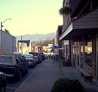
Whitesburg is a home rule-class city in and the county seat of Letcher County, Kentucky, United States. The population was at the 2020 census and an estimated 1,711 in 2022. It was named for John D. White, a state politician and Speaker of the United States House.

Metal Township is a township that is located in Franklin County, Pennsylvania, United States. The population was 1,768 at the time of the 2020 census.
Ping-pong diplomacy refers to the exchange of table tennis (ping-pong) players between the United States and the People's Republic of China in the early 1970s. Considered a turning point in relations between the United States and the People's Republic of China, it began during the 1971 World Table Tennis Championships in Nagoya, Japan, as a result of an encounter between players Glenn Cowan and Zhuang Zedong. These interactions sparked diplomatic breakthrough, by signaling that both sides were willing to interact and engage in dialogue. The exchange and its promotion helped people in each country to recognize the humanity in the people of the other country, and it paved the way for President Richard Nixon's visit to Beijing in 1972 and the Shanghai Communiqué. The Shanghai Communiqué was a pivotal diplomatic document issued on February 28, 1972, during President Richard Nixon's visit to China. It marked a significant shift in U.S.-China relations, as both countries acknowledged their differences while committing to improving their relationship, ultimately setting the stage for détente between the two nations.

Clyde Lorrain Cowan Jr was an American physicist and the co-discoverer of the neutrino along with Frederick Reines. The discovery was made in 1956 in the neutrino experiment. Reines received the Nobel Prize in Physics in 1995.

Cowan Lake, also known as Cowan Creek Reservoir, is a lake within Cowan Lake State Park in Clinton County, Ohio, United States. Its surface area is 692 acres (2.80 km2). Cowan Lake lies near the Cincinnati Arch, an uplifting of bedrock that occurred during the Appalachian Mountains' building process. The erosion of this arch in the Cowan region exposes fossil-rich limestone. The limestone near Cowan and other parts of the exposed arch are some of the most famous fossil hunting fields in the world.

Cowan Lake State Park is a 1,075-acre (435 ha) public recreation area in Clinton County, Ohio, in the United States. It is operated by the Ohio Department of Natural Resources. The state park is open for year-round recreation and is known for a variety of birds that attract birdwatching enthusiasts to the park in southwestern Ohio.

Buchanan State Forest is a Pennsylvania State Forest in Pennsylvania Bureau of Forestry District #2. The main office is located in McConnellsburg in Fulton County, Pennsylvania, in the United States. The forest also includes tracts in Franklin and Bedford Counties. It is named for James Buchanan of Pennsylvania, the fifteenth President of the United States.
Licking Creek is a 56.6-mile-long (91.1 km) tributary of the Potomac River in Pennsylvania and Maryland in the United States.

Cowans Gap State Park is a 1,085-acre (439 ha) Pennsylvania state park in Todd Township, Fulton County and Metal Township, Franklin County, Pennsylvania in the United States. The park is largely surrounded by Buchanan State Forest in Allens Valley just off Pennsylvania Route 75 near Fort Loudon.
Cowan is an unincorporated community in Monroe Township, Delaware County, Indiana.

Big Mountain is the high point on the Tuscarora Mountain ridge in south central Pennsylvania in the United States. The 2,458-foot (749 m) summit is located in the Buchanan State Forest and offers a viewshed that is one of the more stunning in the Commonwealth.
Highway 55 is a paved, undivided provincial highway in the Canadian province of Saskatchewan. It runs from the Alberta border west of Pierceland to Highway 9 near Mountain Cabin. Highway 55 is about 652 kilometres (405 mi) long and forms part of the interprovincial Northern Woods and Water Route.

Low Pass is an unincorporated community in Lane County, Oregon, United States, on the Long Tom River, 5 miles (8 km) east of Blachly and 11 miles (18 km) west of Cheshire.
Tuya Lake, located in northwestern British Columbia, Canada, presumably derives its name from the presence of nearby steep-sided, flat-topped volcanoes, known as tuyas. The lake is situated just south of Tuya Butte at a latitude of about 59 degrees North and a longitude of about 131 degrees West.
Gray Mountain is an unincorporated community in Coconino County, Arizona, United States. Gray Mountain is located on U.S. Route 89, 39 miles (63 km) north-northeast of Flagstaff, and 10 miles (16 km) south-southwest of Cameron. It is assigned the ZIP code 86016.

The Utah Utes baseball team is the varsity intercollegiate baseball program of University of Utah in Salt Lake City, Utah, United States. The program's first season was in 1892, and it was a member of the NCAA Division I Pac-12 Conference from the start of the 2012 season until the conference's collapse after the 2024 season. The Utes will join the Big 12 Conference for the 2025 season and beyond.
Churchill Mountain is a mountain located in the Catskill Mountains of New York east-southeast of Stamford. Utsayantha Mountain is located northeast, Cowan Mountain is located southwest, and McGregor Mountain is located east of Churchill Mountain.
Lyon Mountain is a mountain located in the Catskill Mountains of New York south of Hobart. Cowan Mountain is located east of Lyon Mountain and Griffin Hill is located north.
Cowan Bog Ecological Reserve is an ecological reserve located northeast of the Duck Mountain Provincial Forest, Manitoba, Canada. It was established in 1983 under the Manitoba Ecological Reserves Act. It is 5.18 square kilometres (2.00 sq mi) in size.


