Craignish, Queensland

Last updated

Craignish
Queensland
Craignish Landscape, 2017.jpg
Craignish landscape, 2017
Australia Queensland location map.svg
Red pog.svg
Craignish
Coordinates 25°16′59″S152°43′44″E / 25.2830°S 152.7288°E / -25.2830; 152.7288 (Craignish (centre of locality))
Population2,190 (2021 census) [1]
 • Density141.3/km2 (365.9/sq mi)
Postcode(s) 4655
Area15.5 km2 (6.0 sq mi)
Time zone AEST (UTC+10:00)
Location
LGA(s) Fraser Coast Region
State electorate(s) Maryborough
Federal division(s) Hinkler
Suburbs around Craignish:
Toogoom Hervey Bay Dundowran Beach
Takura Craignish Dundowran
Takura Takura Takura

Craignish is a coastal locality in the Fraser Coast Region, Queensland, Australia. [2] In the 2021 census, Craignish had a population of 2,190 people. [1]

Contents

Geography

The locality is bounded to the west by Toogoom Cane Road, to north-west by O'Regan Creek and to the north by the coast overlooking Hervey Bay. [3]

History

Craignish State School opened on 24 January 1938 on land donated by Mrs Elizabeth (Lizzie) Campbell whose husband Robert had named his property at Dundowran Craignish (a Scottish name meaning rugged rocky place) so the school took this name as a "token of gratitude". [4] [5] The school closed in 1961. [6] It was located at approx 471 Craignish Road ( 25°17′24″S152°44′02″E / 25.2901°S 152.7338°E / -25.2901; 152.7338 (Craignish State School (former)) ). [7] This is presumably the origin of the locality name.

O'Reagan Creek takes its name from Maurice (Morry) O'Regan (1835-1920) who was a pioneer timbergetter in the area. [4] [8]

Demographics

In the 2016 census Craignish had a population of 1,827 people. [9]

In the 2021 census, Craignish had a population of 2,190 people. [1]

Education

There are no schools in Craignish. The nearest government primary school is Yarrilee State School in Urraween to the east. The nearest government secondary school is Hervey Bay State High School in Pialba, also to the east. [10]

Related Research Articles

<span class="mw-page-title-main">Maryborough, Queensland</span> City in Queensland, Australia

Maryborough is a city and a suburb in the Fraser Coast Region, Queensland, Australia. In the 2021 census, the suburb of Maryborough had a population of 15,287 people.

<span class="mw-page-title-main">Biggenden</span> Town in Queensland, Australia

Biggenden is a rural town and locality in the North Burnett Region, Queensland, Australia. In the 2021 census, the locality of Biggenden had a population of 788 people.

<span class="mw-page-title-main">River Heads, Queensland</span> Town in Queensland, Australia

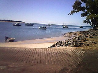
River Heads is a coastal town and locality in the Fraser Coast Region, Queensland, Australia. In the 2021 census, the locality of River Heads had a population of 2,044 people.

<span class="mw-page-title-main">Shire of Woocoo</span> Local government area in Queensland, Australia

The Shire of Woocoo was a local government area located in the Wide Bay–Burnett region of Queensland, Australia, containing the rural residential area to the west of the town of Maryborough, and surrounding countryside. The shire covered an area of 2,007.9 square kilometres (775.3 sq mi), and existed as a local government entity from 1914 until 2008, when it was amalgamated with the City of Maryborough, City of Hervey Bay and the 1st and 2nd divisions of the Shire of Tiaro to form the Fraser Coast Region.

<span class="mw-page-title-main">Howard, Queensland</span> Town in Queensland, Australia

Howard is a rural town and locality in the Fraser Coast Region, Queensland, Australia. It is a southern boundary of the Dundaburra peoples of the Northern Kabi Kabi Isis districts and surrounds. It is located 284 kilometres (176 mi) north of Brisbane and 37 kilometres (23 mi) west of Hervey Bay. In the 2021 census, the locality of Howard had a population of 1,394 people.

<span class="mw-page-title-main">Torquay, Queensland</span> Suburb of Hervey Bay, Queensland, Australia

Torquay is a coastal suburb in Hervey Bay in the Fraser Coast Region, Queensland, Australia. In the 2021 census, Torquay had a population of 6,533 people.

<span class="mw-page-title-main">Pialba</span> Town in Queensland, Australia

Pialba is a coastal town and suburb of Hervey Bay in the Fraser Coast Region, Queensland, Australia. It is the central business district of Hervey Bay. In the 2021 census, the suburb of Pialba had a population of 4,151 people.

<span class="mw-page-title-main">Theebine</span> Town in Queensland, Australia

Theebine is a rural town and locality split between the Gympie Region and the Fraser Coast Region, both in Queensland, Australia.

<span class="mw-page-title-main">Urangan, Queensland</span> Suburb of Hervey Bay, Queensland, Australia

Urangan is a coastal suburb of the city of Hervey Bay in the Fraser Coast Region, Queensland, Australia. In the 2021 census, Urangan had a population of 10,988 people.

<span class="mw-page-title-main">Tinana, Queensland</span> Town in Queensland, Australia

Tinana is a rural town and locality in the Fraser Coast Region, Queensland, Australia. In the 2021 census, the locality of Tinana had a population of 5,872 people.

<span class="mw-page-title-main">Torbanlea</span> Town in Queensland, Australia

Torbanlea is a rural town and locality in the Fraser Coast Region, Queensland, Australia. In the 2021 census, the locality of Torbanlea had a population of 841 people.

<span class="mw-page-title-main">Burrum Heads</span> Town in Queensland, Australia

Burrum Heads is a coastal town and locality in the Fraser Coast Region, Queensland, Australia. In the 2021 census, the locality of Burrum Heads had a population of 2,538 people.

Owanyilla is a rural town and locality in the Fraser Coast Region, Queensland, Australia. In the 2021 census, the locality of Owanyilla had a population of 245 people.

Granville is a rural locality in the Fraser Coast Region, Queensland, Australia. It is a suburb of Maryborough. In the 2021 census, Granville had a population of 2,532 people.

Kanigan is a rural locality split between the Fraser Coast Region and the Gympie Region, both in Queensland, Australia. In the 2021 census, Kanigan had a population of 143 people.

<span class="mw-page-title-main">Munna Creek</span> Suburb of Fraser Coast Region, Queensland, Australia

Munna Creek is a locality split between the Fraser Coast Region and the Gympie Region, in Queensland, Australia. In the 2021 census, Munna Creek had a population of 22 people.

<span class="mw-page-title-main">Toogoom</span> Town in Queensland, Australia

Toogoom is a coastal town and rural locality in the Fraser Coast Region, Queensland, Australia. At the 2021 census, Toogoom had a population of 2,596.

Teddington is a rural locality in the Fraser Coast Region, Queensland, Australia. In the 2021 census, Teddington had a population of 236 people.

Doongul is a rural locality in the Fraser Coast Region, Queensland, Australia. In the 2021 census, Doongul had a population of 35 people.

Paterson is a rural locality in the Fraser Coast Region, Queensland, Australia. In the 2021 census, Paterson had a population of 157 people.

References

  1. 1 2 3 Australian Bureau of Statistics (28 June 2022). "Craignish (SAL)". 2021 Census QuickStats. Retrieved 28 February 2023. OOjs UI icon edit-ltr-progressive.svg
  2. "Craignish – locality in Fraser Coast Region (entry 46642)". Queensland Place Names. Queensland Government . Retrieved 27 December 2020.
  3. "Queensland Globe". State of Queensland . Retrieved 29 December 2020.
  4. 1 2 "CRAIGNISH". Maryborough Chronicle, Wide Bay and Burnett Advertiser . No. 20, 686. Queensland, Australia. 25 February 1938. p. 6. Retrieved 29 December 2020 via National Library of Australia.
  5. "Advertising". The Telegraph . Queensland, Australia. 5 April 1941. p. 19 (SPORTS FINAL). Retrieved 29 December 2020 via National Library of Australia.
  6. Queensland Family History Society (2010), Queensland schools past and present (Version 1.01 ed.), Queensland Family History Society, ISBN   978-1-921171-26-0
  7. "Queensland Two Mile series sheet 2m112" (Map). Queensland Government. 1956. Archived from the original on 29 December 2020. Retrieved 29 December 2020.
  8. "AN OLD PIONEER". Maryborough Chronicle, Wide Bay and Burnett Advertiser . No. 14, 543. Queensland, Australia. 31 August 1920. p. 2. Retrieved 29 December 2020 via National Library of Australia.
  9. Australian Bureau of Statistics (27 June 2017). "Craignish (SSC)". 2016 Census QuickStats. Retrieved 20 October 2018. OOjs UI icon edit-ltr-progressive.svg
  10. "Layers: Locality; Schools and school catchments". Queensland Globe. Queensland Government. Archived from the original on 19 December 2017. Retrieved 13 July 2024.