
Sullivan County is a county in the U.S. state of New York. As of the 2020 census, the population was 78,624. The county seat is Monticello. The county's name honors Major General John Sullivan, who was labeled at the time as a hero in the American Revolutionary War in part due to his successful campaign against the Iroquois. The county is part of the Hudson Valley region of the state.

Washington County is a county located in the U.S. state of Tennessee. As of the 2020 census, the population was 133,001. Its county seat is Jonesborough. The county's largest city and a regional educational, medical and commercial center is Johnson City. Washington County is Tennessee's oldest county, having been established in 1777 when the state was still part of North Carolina. Washington County is part of the Johnson City, TN Metropolitan Statistical Area, which is a component of the Johnson City–Kingsport–Bristol, TN-VA Combined Statistical Area, commonly known as the "Tri-Cities" region.

Sullivan County is a county located in the U.S. state of Tennessee on its northeast border. As of the 2020 census, the population was 158,163. Its county seat is Blountville. Sullivan County is part of the Kingsport–Bristol TN-VA Metropolitan Statistical Area, which is a component of the Kingsport–Johnson City–Bristol, TN-VA Combined Statistical Area, commonly known as the "Tri-Cities" region. Sullivan is Tennessee's second-oldest county; it was established in 1779 when the area was still part of North Carolina. From 1784 to 1788, it was part of the extra-legal State of Franklin.

Johnson County is a county located in the U.S. state of Tennessee. As of the 2020 census, the population was 17,948. Its county seat is Mountain City. It is the state's northeasternmost county, sharing borders with Virginia and North Carolina.

Sullivan County is a county in the Commonwealth of Pennsylvania. As of the 2020 census, the population was 5,840, making it the second-least populous county in Pennsylvania. Its county seat is Laporte. The county was created on March 15, 1847, from part of Lycoming County and named for Major General John Sullivan. The county is part of the Northeast Pennsylvania region of the state.
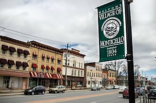
Monticello is a village located in Thompson, Sullivan County, within the Catskills region of New York, United States. It is the seat for the town of Thompson, and the county seat of Sullivan County. The population was 7,173 at the 2020 census. The village was named after the residence of Thomas Jefferson.

Rusk is a city in and the county seat of Cherokee County, Texas, United States. At the 2020 United States census, it had a population of 5,285.

The Cherokee National Forest is a United States National Forest located in the U.S. states of Tennessee and North Carolina that was created on June 14, 1920. The forest is maintained and managed by the United States Forest Service. It encompasses an estimated area of 655,598 acres (2,653.11 km2).
The Colville National Forest is a U.S. National Forest located in northeastern Washington state. It is bordered on the west by the Okanogan–Wenatchee National Forest and the Kaniksu National Forest to the east. The forest also borders Little Pend Oreille National Wildlife Refuge and the Lake Roosevelt National Recreation Area.
TouVelle State Recreation Site is a state park, administered by Oregon Parks and Recreation Department, and located in Jackson County, Oregon, United States, 9 miles (14 km) north of Medford, where Table Rock Road crosses the Rogue River. This 51-acre (210,000 m2) park is used for fishing, birding, hiking, picnicking and swimming. There is also a boat ramp, which lies at the lower end of an easily navigated stretch of the Rogue. A daily user-fee or annual permit is required.
Regions of Pennsylvania in the United States include:
The Denman Wildlife Area is a wildlife management area near Eagle Point, Oregon, in the United States. It was named in honor of Kenneth Denman, an attorney from nearby Medford, Oregon, who lobbied for the creation of the area in 1954.

The Red Hill Fire Observation Station consists of a fire lookout tower, cabin and pit privy located on the summit of Red Hill, a 2,990-foot (910 m) Catskill Mountain peak in Denning, New York, United States. It is the southernmost fire tower in the Catskill Park.

Pennsylvania State Game Lands Number 13 are Pennsylvania State Game Lands in Columbia County and Sullivan County, in Pennsylvania, in the United States. They have an area of 49,529 acres. The game lands are mountainous and contain streams such as West Branch Fishing Creek and its tributaries. The main game animals in the area include bear, deer, grouse, turkey, and waterfowl. The game lands are adjacent to Pennsylvania State Game Lands Number 57.

Denman Peak is a small 6,006 ft summit in the Tatoosh Range which is a sub-range of the Cascade Range. It's located south of Mount Rainier within Mount Rainier National Park. Denman Peak is situated east of Lane Peak and west of Pinnacle Peak.
Van Loan Hill is a mountain in Greene County, New York. It is located in the Catskill Mountains southwest of Maplecrest. Round Hill is located west, Elm Ridge is located north-northeast, and East Jewett Range is located south of Van Loan Hill.
Sugarloaf Mountain is a mountain in Sullivan County, New York. It is located northeast of Grahamsville. Denman Mountain is located west-northwest, Kalonymus Escarpment is located south-southeast, and South Hill is located south-southwest of Sugarloaf Mountain.
Blue Hill is a mountain in Sullivan County, New York. It is located west-southwest of Claryville. Denman Mountain is located east-southeast of Blue Hill.
Chapin Hill is a 1,427-foot-tall (435 m) mountain in the state of New York. It is located southwest of Monticello in Sullivan County. In 1924, a 60-foot-tall (18 m) steel fire lookout tower was built on the mountain. Due to increased use of aerial fire detection, the tower closed at the end of the 1970 fire season, and was later removed.

