
Sugarloaf Township, or Sugarloaf for short, is a township that is located in Luzerne County, Pennsylvania, United States. The population was 3,879 at the time of the 2020 census.
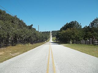
Sugarloaf Mountain is the fifth-highest named point and the most prominent point in the U.S. state of Florida. At 312 feet above sea level it is also the highest point on the geographic Florida Peninsula. The hill is in Lake County, near the town of Clermont.
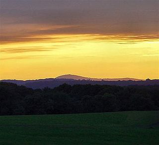
Sugarloaf Mountain is a small mountain and park about 10 miles (16 km) south of Frederick, Maryland. The closest village is Barnesville, located just over one mile from the foot of the mountain. The peak of this relatively low mountain is approximately 800 feet higher than the surrounding farmland. It is visible from many parts of northern Montgomery County and southern Frederick County, notably from I-270 north of the town of Germantown. Because of its geological and natural history interest, it was designated a National Natural Landmark in 1969. It is a notable example of an admission-free, privately owned scenic park.

The Hudson Highlands are mountains on both sides of the Hudson River in New York state lying primarily in Putnam County on its east bank and Orange County on its west. They continue somewhat to the south in Westchester County and Rockland County, respectively. The highlands are a subrange of the Appalachian Mountains.

The Carrabassett River, a tributary of the Kennebec River, is located in Franklin County and Somerset County, Maine, in the United States. It rises near Sugarloaf Mountain, east of Rangeley Lake, and runs for 33.8 miles (54.4 km), flowing southeast past Kingfield and joining the Kennebec River in the town of Anson.

Crocker Mountain is a 4,228 ft (1,289 m) peak located in Carrabassett Valley, Franklin County, Maine, in the United States. Crocker Mountain is the fourth highest mountain in the state after the Katahdins and Sugarloaf Mountain, and is part of the Appalachian Mountains. Crocker Mountain is traversed by the Appalachian Trail (AT), a 2,170 mi (3,490 km) National Scenic Trail from Georgia to Maine.

Sugarloaf Mountain is a ski mountain located in Carrabassett Valley, Franklin County, Maine. It is the third highest peak in the state, after Mount Katahdin's Baxter and Hamlin peaks. Sugarloaf is flanked to the south by Spaulding Mountain.

Mount Redington is a mountain located in Franklin County, Maine. Redington is flanked to the northeast by South Crocker Mountain and to the west by Black Nubble. Redington stands just northeast of the U.S. Navy Survival Escape and Evasion Training Facility (USSEAETF).
Spaulding Mountain is a mountain located in Franklin County, Maine. Spaulding Mountain is flanked to the northeast by Sugarloaf Mountain, and to the southeast by Mount Abraham.

South Crocker Mountain is a mountain located in Franklin County, Maine. South Crocker Mountain is flanked to the north by Crocker Mountain, and to the southwest by Mount Redington.

Sugarloaf Ridge State Park is a state park in Northern California, United States. Located in the Mayacamas Mountains north of Kenwood, the park straddles the boundary between Sonoma and Napa counties. The park contains the 2,729-foot (832 m) Bald Mountain and the headwaters of Sonoma Creek including a 25-foot (8 m) tall seasonal waterfall. The park is also home to the volunteer-run Robert Ferguson Observatory. Camping, picnicking, horseback riding, mountain biking, stargazing, fishing and hiking are common attractions of Sugarloaf. The park boasts 25 miles of trails with trails ranging from less than a mile to 8.8 miles, and elevation gains reaching 2,500 feet.

Mount Sugarloaf State Reservation is a state-owned, public recreation area managed by the Massachusetts Department of Conservation and Recreation located in South Deerfield, just west of the Connecticut River. The state park includes the summits of North Sugarloaf Mountain and South Sugarloaf Mountain, as well as 1.75 miles of frontage on the Connecticut River and two river islands. The park is part of a larger park designation called the Connecticut River Greenway State Park. Portions of the park property along the river are used by the University of Massachusetts Amherst for agricultural research.

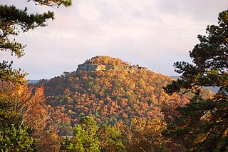
Sugarloaf Mountain or Mount Sugarloaf, is a butte-like mountain located in South Deerfield, Massachusetts, United States, with two summits, North Sugarloaf Mountain 791 ft (241 m) and its more popular knee, South Sugarloaf Mountain 652 ft (199 m). Its cliffs, made of arkose sandstone, are a very prominent landscape feature visible for miles. Despite low elevations relative to the Berkshire Mountains to the west, dramatic cliff faces and a rise of 500 feet (150 m) to 600 feet (180 m) from the nearby Connecticut River make the mountain a popular tourist and hiking destination. Sugarloaf Mountain is the southern terminus of the Pocumtuck Range.
The Pocumtuck Range, also referred to as the Pocumtuck Ridge, is the northernmost subrange of the Metacomet Ridge mountain range of southern New England, itself a subrange of the Appalachian Mountains. Located in Franklin County, Massachusetts, between the Connecticut River and the Deerfield River valleys, the Pocumtuck Range is a popular hiking destination known for its continuous high cliffs, scenic vistas, and microclimate ecosystems.

Sugarloaf Mountain is a mountain located in Greene County, New York. The mountain is part of the Devil's Path range of the Catskill Mountains. To the northwest, Sugarloaf is separated from Plateau Mountain by Mink Hollow Notch; to the southeast, Sugarloaf is separated from Twin Mountain by Pecoy Notch.
Sugarloaf Mountain is a hiking and mountain biking destination located in Cleburne County, Arkansas, east of the city of Heber Springs, Arkansas. It is 690 feet tall, and is topped by an Atoka formation, a geologic formation sequence of sandstone, siltstone, and shale.
Sugarloaf is in the name of two different mountains that are located in Butte County of northern California.

Mountain Meadows is an unincorporated community and a census-designated place (CDP) located in and governed by Boulder County, Colorado, United States. The CDP is a part of the Boulder, CO Metropolitan Statistical Area. The population of the Mountain Meadows CDP was 237 at the United States Census 2020. The Boulder post office serves the area.

Sugarloaf is an unincorporated community and a census-designated place (CDP) located in and governed by Boulder County, Colorado, United States. The CDP is a part of the Boulder, CO Metropolitan Statistical Area. The population of the Sugarloaf CDP was 274 at the United States Census 2020. The Boulder post office serves the area.

Sugarloaf Mountain is a 900-foot (270 m) peak located in the town of Fishkill near the Hudson River and Breakneck Ridge. One of several similarly named mountains in the U.S. state of New York, it is part of the Hudson Highlands, located entirely within Hudson Highlands State Park.

