
William Penn University is a private university in Oskaloosa, Iowa. It was founded by members of the Religious Society of Friends (Quakers) in 1873 as Penn College. In 1933, the name was changed to William Penn College, and finally to William Penn University in 2000.

In the law regulating historic districts in the United States, a contributing property or contributing resource is any building, object, or structure which adds to the historical integrity or architectural qualities that make the historic district significant. Government agencies, at the state, national, and local level in the United States, have differing definitions of what constitutes a contributing property but there are common characteristics. Local laws often regulate the changes that can be made to contributing structures within designated historic districts. The first local ordinances dealing with the alteration of buildings within historic districts was passed in Charleston, South Carolina in 1931.

The Mahaska County Courthouse located in Oskaloosa, Iowa, United States, was built in 1886. It was individually listed on the National Register of Historic Places in 1981 as a part of the County Courthouses in Iowa Thematic Resource. In 1986 it was included as a contributing property in the Oskaloosa City Square Commercial Historic District. The courthouse is the second building the county has used for court functions and county administration.
Frank E. Wetherell (1869-1961) was an architect in the U.S. state of Iowa who worked during 1892–1931. He founded the second oldest architectural firm in the state in Des Moines, Iowa, in 1905. He worked with Roland Harrison in partnership Wetherell & Harrison. The firm designed numerous Masonic buildings.

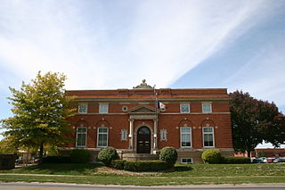
The Oskaloosa City Hall is a historic government building located in Oskaloosa, Iowa, United States. It was designed by Des Moines architect Frank E. Wetherell, an Oskaloosa native, in the Renaissance Revival style. It was originally designed along with the adjoining fire station in 1905. The buildings were designed for phased construction, and the city council decided to build the fire station first. It was individually listed on the National Register of Historic Places in 1991. Previously it had been included as a contributing property in the Oskaloosa City Square Commercial Historic District.

The Oskaloosa City Park and Band Stand is a nationally recognized historic district located in Oskaloosa, Iowa, United States. It was listed on the National Register of Historic Places in 1983. The listing includes one contributing site and five contributing objects. The town square, which is the site, was part of the original town plat in 1844. Landscaping projects were undertaken in the 1860s, 1911 and 1970–1971. In addition to the landscaping the sidewalks and curbing were installed in 1911. The bandstand in the center was designed by Des Moines architect Frank E. Wetherell, an Oskaloosa native, and built in 1912. The 29-foot (8.8 m) high octagonal structure is composed of concrete, iron and steel.

The Oskaloosa Fire Station is a historic building located in Oskaloosa, Iowa, United States. It was designed by Des Moines architect Frank E. Wetherell, an Oskaloosa native, in the Renaissance Revival style. It was originally designed along with the adjoining city hall in 1905. The buildings were designed for phased construction, and the city council decided to build the fire station first. Completed in 1908, it is a three-story brick building with a 4½-story bell tower. The fire station was individually listed on the National Register of Historic Places in 1991. Previously it had been included as a contributing property in the Oskaloosa City Square Commercial Historic District.

The Oskaloosa City Square Commercial Historic District is a 9.8-acre (4.0 ha) historic district in Oskaloosa, Iowa that includes Early Commercial, Italianate, and Romanesque Revival architecture. It was listed on the National Register of Historic Places in 1986. At the time of its nomination it included 68 contributing buildings.
Oskaloosa Public Library is a facility located in Oskaloosa, Iowa, United States. Construction of the library was launched in 1902 with a grant from the Carnegie Corporation of New York. The building was added to the National Register of Historic Places in 1991.

The Paradise Block Historic District is a nationally recognized historic district located in Oskaloosa, Iowa, United States. It was listed on the National Register of Historic Places in 1991. At the time of its nomination it contained 43 resources, which included 26 residences, two churches, 12 garages, two brick driveways, and a vacant lot. Of these, 35 are considered contributing properties. The eight non-contributing properties include the vacant lot, two houses and a garage built after 1935, and four otherwise historic houses that have been significantly altered and have lost significant architectural elements. The contributing properties were built between 1853 and 1917, with 15 of them being built between 1880 and 1900. Two of the houses, the Smith-Johnson House (1853) and the Seeberger-Loring-Kilburn House (1859), are individually listed on the National Register. The churches include the First Church of Christ, Scientist (1912), a Neoclassical structure covered with stucco, and St. Paul Congregational United Church of Christ (1914), a Neoclassical brick structure.

Le Mars Municipal Park and Golf Course Historic District is a nationally recognized historic district located in Le Mars, Iowa, United States. It was listed on the National Register of Historic Places in 2001. At the time of its nomination the district consisted of 25 resources, including 11 contributing buildings, one contributing site, four contributing structures, eight non-contributing buildings, and one non-contributing structure.

The Lincoln–Fairview Historic District is a nationally recognized historic district located in Council Bluffs, Iowa, United States. It was listed on the National Register of Historic Places in 2007. At the time of its nomination the district consisted of 327 resources, including 264 contributing buildings, two contributing sites, four contributing structures, three contributing objects, 52 non-contributing buildings, and two non-contributing structures. The district is primarily a residential area north of the central business district. It includes the steep loess bluff where President Abraham Lincoln stood to survey the area when he was deciding on the eastern terminus of the Union Pacific Railroad. The Daughters of the American Revolution erected a monument at the location in 1911.

Old Main Street Historic District is a nationally recognized historic district located in Dubuque, Iowa, United States. It was listed on the National Register of Historic Places in 1983. At the time of its nomination it consisted of 33 resources, which included 30 contributing buildings and three non-contributing buildings. In 2015 the boundaries were increased to include five more buildings. Four of the buildings are contributing properties that were excluded from the original district because they were slated to be torn down as a part of the expansion of U.S. Route 61. While the highway was built the buildings were spared. The fifth building is non-contributing as are three structures.

The College Green Historic District is a nationally recognized historic district located in Iowa City, Iowa, United States. It was listed on the National Register of Historic Places in 1997. At the time of its nomination it consisted of 47 resources, which included 37 contributing buildings, one contributing site, and nine non-contributing buildings. This neighborhood in the central part of the city surrounds a square-block park called College Green, from which it derives its name. The park, which is the contributing site, is found on the earliest maps of Iowa City. While the earliest houses in the district were built in the 1860s, most were constructed between 1890 and 1920. No one architectural style dominates here, but the district contains a variety of styles that were popular in the late 19th and early 20th centuries. This is one of three areas in the city where the fraternities and sororities associated with the University of Iowa are located. The Thomas C. Carson House (1875), which now houses a sorority, is individually listed on the National Register of Historic Places.

The Longfellow Historic District is a nationally-recognized historic district located in Iowa City, Iowa, United States. It was listed on the National Register of Historic Places in 2002. At the time of its nomination, it consisted of 355 resources, which included 250 contributing buildings, 103 non-contributing buildings, and two non-contributing structures. As the University of Iowa expanded in the early 20th-century new sections were being added to the city. The Longfellow neighborhood, named after the local elementary school completed in 1919, was part of this expansion. The northern part of the neighborhood along East Court Street developed in the 19th century because the street connected the city center to the Muscatine road. The rest of the neighborhood was platted on farm land in 1908 and 1914. A trolley line was completed to the area in 1910, leading to the creation of suburban development.

The Melrose Historic District is a nationally recognized historic district located in Iowa City, Iowa, United States. It was listed on the National Register of Historic Places in 2004. At the time of its nomination it consisted of 134 resources, which included 112 contributing buildings, one contributing site, 20 non-contributing buildings, and one non-contributing structure. This neighborhood first developed as a sparsely populated rural area, and between World War I and World War II developed into an automobile suburb. It grew along with the University of Iowa when it expanded to the west side of the Iowa River, and it borders the large University of Iowa Hospitals and Clinics complex. Among the prominent people who lived here was Howard Jones who coached the Iowa football team from 1916 to 1923. Other prominent residents included professors and local professionals and politicians.

The Johnson County Poor Farm and Asylum Historic District is a nationally recognized historic district located in Iowa City, Iowa, United States. It was listed on the National Register of Historic Places in 2014. At the time of its nomination it consisted of 11 resources, which included three contributing buildings, two contributing sites, four contributing structures and two non-contributing buildings. It also includes the First Johnson County Asylum, which was individually listed on the National Register. The remaining buildings and structures are agricultural in nature, and were built from the late 19th-century to the early 20th-century.

The Marion Commercial Historic District is a nationally recognized historic district located in Marion, Iowa, United States. It was listed on the National Register of Historic Places in 2009. At the time of its nomination it consisted of 41 resources, which included 29 contributing buildings, one contributing site, one contributing structure, two contributing objects, and eight non-contributing buildings. The historic district covers the city's central business district. The development of this area largely occurred when Marion was the county seat of Linn County (1838-1919). There are no county government buildings extant from this era. The city was also a division point for the Chicago, Milwaukee, St. Paul and Pacific Railroad in the late nineteenth and early twentieth centuries.

East Park is a recreational park located in Mason City, Iowa, United States. It was listed as a historic district on the National Register of Historic Places in 2014. At the time of its nomination it contained 21 resources, which included three contributing buildings, one contributing site, five structures, seven non-contributing buildings, and five non-contributing structures. It contains 57.6 acres (23.3 ha) of land along the Winnebago River. The park features picnic areas, a 9-hole disc golf course, three tennis courts, volleyball court, basketball courts, fishing, a sledding hill, playgrounds including the Prairie Playground, a 2.08-mile (3.35 km) hard surface trail system, a band shell and a gazebo.

The Camp Harlan-Camp McKean Historic District, also known as the Hugh B. and Mary H. Swan Farmstead and the Springdale Stock Farm, is a nationally recognized historic district located northwest of Mount Pleasant, Iowa, United States. It was listed on the National Register of Historic Places in 2013. At the time of its nomination it consisted of eight resources, which includes two contributing buildings, one contributing site, one contributing object and four non-contributing buildings.


