Effects of tropical cyclones

Last updated
Percentages of hurricane deaths in the United States from 1970 to 1999. Cyclone Deaths.svg
Percentages of hurricane deaths in the United States from 1970 to 1999.

The effects of tropical cyclones include heavy rain, strong wind, large storm surges near landfall, and tornadoes. The destruction from a tropical cyclone, such as a hurricane or tropical storm, depends mainly on its intensity, its size, and its location. Tropical cyclones remove forest canopy as well as change the landscape near coastal areas, by moving and reshaping sand dunes and causing extensive erosion along the coast. Even well inland, heavy rainfall can lead to landslides in mountainous areas. Their effects can be sensed over time by studying the concentration of the Oxygen-18 isotope within caves.

Contents

After the cyclone has occurred, devastation often continues. Fallen trees can block roads and delay rescues, with medical supplies, or slow the repairs to electrical lines, telephone towers or water pipes, which could put other lives at risk for days or months. Stagnant water can cause the spread of disease, and transportation or communication infrastructure may have been destroyed, hampering clean-up and rescue efforts. Nearly 2 million people have died globally due to tropical cyclones. Despite their devastating effects, tropical cyclones are also beneficial, by potentially bringing rain to dry areas and moving heat from the tropics poleward. Out at sea, ships take advantage of their known characteristics by navigating through their weaker, western half.

Hazards are often characterized as primary, secondary or tertiary. A primary hazard involves destructive winds, debris and storm surge. Secondary hazards include flooding and fires. Tertiary hazards include spikes in prices of food and other necessities, as well as long term hazards like water-borne diseases.

At sea

The exports and imports are halted in sea ports due to the cyclone. Some people lose their jobs as well. A mature tropical cyclone can release heat at a rate upwards of 6×10¹⁴ watts. [1] Tropical cyclones on the open sea cause large waves, heavy rain, and high winds, disrupting international shipping and, at times, causing shipwrecks. [2] Generally, after its passage, a tropical cyclone stirs up ocean water, lowering sea surface temperatures behind it. [3] This cool wake can cause the region to be less favorable for a subsequent tropical cyclone. On rare occasions, tropical cyclones may actually do the opposite. 2005's Hurricane Dennis blew warm water behind it, contributing to the unprecedented intensity of Hurricane Emily, which followed it closely. [4] Hurricanes help to maintain the global heat balance by moving warm, moist tropical air to the mid-latitudes and polar regions [5] and also by influencing ocean heat transport. [6] Were it not for the movement of heat poleward (through other means as well as hurricanes), the tropical regions would be unbearably hot.

North American colonization

Shipwrecks are common with the passage of strong tropical cyclones. Such shipwrecks can change the course of history, [7] as well as influence art and literature. A hurricane led to a victory of the Spanish over the French for control of Fort Caroline, and ultimately the Atlantic coast of North America, in 1565. [8] The Sea Venture was wrecked near Bermuda in 1609 which led to the colonization of Bermuda [9] and provided the inspiration for Shakespeare's The Tempest .

Shipping

The dangerous semicircle is the upper-right corner, with the arrow marking the direction of motion of a Northern Hemisphere storm. Note that typhoons, etc. are asymmetrical, and semicircle is a convenient misnomer. Typhoons and Wind Speeds.gif
The dangerous semicircle is the upper-right corner, with the arrow marking the direction of motion of a Northern Hemisphere storm. Note that typhoons, etc. are asymmetrical, and semicircle is a convenient misnomer.

Mariners have a way to safely navigate around tropical cyclones. They split tropical cyclones in two, based on their direction of motion, and maneuver to avoid the right segment of the cyclone in the Northern Hemisphere (the left segment in the Southern Hemisphere). Sailors term the right side the dangerous semicircle since the heaviest rain and strongest winds and seas were located in this half of the storm, as the cyclone's translation speed and its rotational wind are additive. The other half of the tropical cyclone is called the navigable semicircle [10] since weather conditions are lessened (subtractive) in this portion of the storm (but are still potentially quite hazardous). The rules of thumb for ship travel when a tropical cyclone is in their vicinity are to avoid them if at all possible and do not cross their forecast path (crossing the T). Those traveling through the dangerous semicircle are advised to keep to the true wind on the starboard bow and make as much headway as possible. Ships moving through the navigable semicircle are advised to keep the true wind on the starboard quarter while making as much headway as possible. [11] [12]

Upon landfall

The number of $1 billion Atlantic hurricanes almost doubled from the 1980s to the 2010s, and inflation-adjusted costs have increased more than elevenfold. The increases have been attributed to climate change and to greater numbers of people moving to coastal areas. 1980- Cost of billion dollar hurricanes - US - variwide chart - NOAA data.svg
The number of $1 billion Atlantic hurricanes almost doubled from the 1980s to the 2010s, and inflation-adjusted costs have increased more than elevenfold. The increases have been attributed to climate change and to greater numbers of people moving to coastal areas.

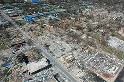
The most significant effects of a tropical cyclone occur when they cross coastlines, making landfall then it destroys ships and lives.

Broken concrete utility pole in Puerto Rico after Hurricane Maria in 2017, which ranks fourth in costliest US tropical cyclones. Hurricane-damaged concrete utility pole, Nov. 9 near PR-482 in Puerto Rico.jpg
Broken concrete utility pole in Puerto Rico after Hurricane Maria in 2017, which ranks fourth in costliest US tropical cyclones.

Strong winds

Strong winds can damage or destroy vehicles, buildings, bridges, trees, personal property and other outside objects, turning loose debris into deadly flying projectiles. In the United States, major hurricanes comprise just 21% of all land-falling tropical cyclones, but account for 83% of all damage. [14] Tropical cyclones often knock out power to tens or hundreds of thousands of people, preventing vital communication and hampering rescue efforts. [15] Tropical cyclones often destroy key bridges, overpasses, and roads, complicating efforts to transport food, clean water, and medicine to the areas that need it. Furthermore, the damage caused by tropical cyclones to buildings and dwellings can result in economic damage to a region, and to a diaspora of the population of the region. [16]

Storm surge

The aftermath of Hurricane Katrina in Gulfport, Mississippi. Katrina was the costliest tropical cyclone in United States history. Hurricane katrina damage gulfport mississippi.jpg
The aftermath of Hurricane Katrina in Gulfport, Mississippi. Katrina was the costliest tropical cyclone in United States history.

The storm surge, or the increase in sea level due to the cyclone, is typically the worst effect from landfalling tropical cyclones, historically resulting in 90% of tropical cyclone deaths. [16] The relatively quick surge in sea level can move miles/kilometers inland, flooding homes and cutting off escape routes. The NOAA report about sea level states that the likeliness of storm surges during a hurricane has increased due to climate change, and by 2050, the chance of moderate flooding occurring will have increased by 10 times. [18] [19] The storm surges and winds of hurricanes may be destructive to human-made structures, but they also stir up the waters of coastal estuaries, which are typically important fish-breeding locales.

Heavy rainfall

The thunderstorm activity in a tropical cyclone produces intense rainfall, potentially resulting in flooding, mudslides, and landslides. Inland areas are particularly vulnerable to freshwater flooding, due to residents not preparing adequately. [20] Heavy inland rainfall eventually flows into coastal estuaries, damaging marine life in coastal estuaries. [21] The wet environment in the aftermath of a tropical cyclone, combined with the destruction of sanitation facilities and a warm tropical climate, can induce epidemics of disease which claim lives long after the storm passes. [16] Infections of cuts and bruises can be greatly amplified by wading in sewage-polluted water. Large areas of standing water caused by flooding also contribute to mosquito-borne illnesses. Furthermore, crowded evacuees in shelters increase the risk of disease propagation. [16]

Flooding in Port Arthur, Texas caused by Hurricane Harvey. Harvey was the wettest and second-costliest tropical cyclone in United States history. Support during Hurricane Harvey (TX) (50).jpg
Flooding in Port Arthur, Texas caused by Hurricane Harvey. Harvey was the wettest and second-costliest tropical cyclone in United States history.

Although cyclones take an enormous toll in lives and personal property, they may be important factors in the precipitation regimes of places they affect and bring much-needed precipitation to otherwise dry regions. Hurricanes in the eastern north Pacific often supply moisture to the Southwestern United States and parts of Mexico. [22] Japan receives over half of its rainfall from typhoons. [23] Hurricane Camille (1969) averted drought conditions and ended water deficits along much of its path, [24] though it also killed 259 people and caused $9.14 billion (2005 USD) in damage.

On the other hand, the occurrence of tropical cyclones can cause tremendous variability in rainfall over the areas they affect: indeed cyclones are the primary cause of the most extreme rainfall variability in the world, as observed in places such as Onslow and Port Hedland in subtropical Australia where the annual rainfall can range from practically nothing with no cyclones to over 1,000 millimetres (39 in) if cyclones are abundant.

Tornadoes

The broad rotation of a land-falling tropical cyclone often (though not commonly) spawns tornadoes, particularly in their right front quadrant. While these tornadoes are normally not as strong as their non-tropical counterparts, heavy damage or loss of life can still occur. Tornadoes can also be spawned as a result of eyewall mesovortices, which persist until landfall. [25]

Deaths

Deaths per year from tropical cyclones
Australia5 [26]
United States25 [27]
East Asia740 [28]
Globally10000 [27]

During the last two centuries, tropical cyclones have been responsible for the deaths of about 1.9 million people worldwide. It is estimated that 10,000 people per year perish due to tropical cyclones. [27] The deadliest tropical cyclone was the 1970 Bhola cyclone, which had a death toll of anywhere from 300,000 to 500,000 lives.

United States

Before Hurricane Katrina, which combined storm-tide flooding with levee-breach (dam) flooding from Lake Pontchartrain, the average death rate for tropical cyclones in the United States had been decreasing. The main cause of storm-related fatalities had been shifting away from storm surge and towards freshwater (rain) flooding. [29] However, the median death rate per storm had increased through 1979, with a lull during the 1980–1995 period. This was due to greater numbers of people moving to the coastal margins and into harm's way. Despite advances in warning strategies and reduction in track forecast error, this increase in fatalities is expected to continue for as long as people migrate towards the shore. [30]

Reconstruction and repopulation

Aerial image of destroyed houses in Tacloban, following Typhoon Haiyan Aerial view of Tacloban after Typhoon Haiyan.jpg
Aerial image of destroyed houses in Tacloban, following Typhoon Haiyan

While tropical cyclones may well seriously damage settlement, total destruction encourages rebuilding. For example, the destruction wrought by Hurricane Camille on the Gulf coast spurred redevelopment, greatly increasing local property values. [24] Research indicates that the typical hurricane strike raises real house prices by a few percent for a number of years, with a maximum effect of between 3 percent to 4 percent three years after occurrence. [31] However, disaster response officials point out that redevelopment encourages more people to live in clearly dangerous areas subject to future deadly storms. Hurricane Katrina is the most obvious example, as it devastated the region that had been revitalized after Hurricane Camille. Many former residents and businesses do relocate to inland areas away from the threat of future hurricanes as well.

In isolated areas with small populations, tropical cyclones may cause enough casualties to contribute to the founder's effect as survivors repopulate their place. For example, around 1775, a typhoon hit Pingelap Atoll, and in combination with a subsequent famine, reduced the island's population to a low level. Several generations after the disaster, as many as 10% of Pingelapese have a genetic form of color-blindness called achromatopsia. [32] This is due to one of the survivors of the depopulation brought on by the typhoon having a mutated gene, which the population bottleneck caused to be at a higher-than-usual level in succeeding generations. [32]

Hurricane Isabel (2003)'s effect on the North Carolina Outer Banks FEMA - 8414 - Photograph by Mark Wolfe taken on 09-20-2003 in North Carolina.jpg
Hurricane Isabel (2003)'s effect on the North Carolina Outer Banks

Effects on natural resources

Geomorphology

Tropical cyclones reshape the geology near the coast by eroding sand from the beach as well as offshore, rearranging coral, and changing dune configuration onshore. Their rainwater gets absorbed into stalagmites within caves, creating a record of past tropical cyclone impacts.

Coastal ridges

Waves and storm surges accompanying tropical cyclones undersea sands, erode shell deposits, break off corals from near shore reefs in their paths, and carry all this detritus landwards in a rolling wave of material that is deposited onshore, above highest astronomical tide as a ridge of sand, shell and coral. [33] For example, each severe tropical cyclone (i.e. Category 4–5 on the Saffir-Simpson scale) crossing northeast Australia's tropical coastline since the last significant change in sea levels (about 5,000 years ago) has 'emplaced' such ridges within the coastal landscape forming, in some places, series of ridges and a geomorphological record of highest magnitude cyclones hitting the coast over 3,000–5,000 years. [34]

Eyewitness accounts verify ridges of this kind are formed by severe tropical cyclones and two clear examples cited are the 18 kilometres (11 mi) long, 35 metres (115 ft) wide, 3.5 metres (11 ft) high coral shingle ridge deposited on Funafuti Atoll (Central South Pacific) by Cyclone Bebe in October 1972, and the large coral shingle ridge deposited on Jaluit Atoll (Marshall Islands) by Typhoon Ophelia in January 1958. In tropical northeast Australia, an intense tropical cyclone hit in March 1918 (crossing over the town of Innisfail), at which time there were eyewitness accounts of a 4.5 metres (15 ft) to 5.1 metres (17 ft) high ridge of pumice being deposited by that cyclone's surge as it crossed the coast.). [33]

Limestone cave stalagmites

When tropical cyclones cross land, thin layers of calcium carbonate of 'light' composition (i.e. unusual isotopic ratio of Oxygen-18 and Oxygen-16) are deposited onto stalagmites in limestone caves up to 300 kilometres (190 mi) from the cyclone's path. [34]

As the cloud tops of tropical cyclones are high and cold, and their air is humid – their rainwater is 'lighter'. In other words, the rainfall contains significantly higher quantities of unevaporated Oxygen-18 than other tropical rainfall. The isotopically lighter rainwater soaks into the ground, percolates down into caves, and, within a couple of weeks, Oxygen-18 transfers from the water into calcium carbonate, before being deposited in thin layers or 'rings' within stalagmites. A succession of such events created within stalagmites maintain a record of cyclones tracking within a 300 kilometres (190 mi) radius of caves going back centuries, millennia, or even millions of years. [35]

At Actun Tunichil Muknal cave in central Belize, researchers drilling stalagmites with a computer- controlled dental drill accurately identified and verified evidence of isotopically light rainfall for 11 tropical cyclones occurring over a 23-year period (1978–2001). [35]

At the Chillagoe limestone caves in northeast Australia (130 kilometres (81 mi) inland from Cairns) researchers identified and matched evidence of isotopically light rainfall with 100 years of cyclone records, and from this have created a record of tropical cyclones from 2004 back to 1200 A.D. (an 800-year record). [34]


Landscapes

Severe tropical cyclones defoliate tropical forest canopy trees, remove vines and epiphytes from the trees, break tree crown stems, and cause tree falls. The degree of damage they do along their paths, at a landscape level (i.e. > 10 kilometres (6.2 mi)), can be catastrophic yet variable and patchy. [36] Trees will break at 42 m/s (150 km/h; 94 mph), regardless of size and type. [37] [38] Stripping trees and scattering forest debris also provides fuel for wildfires, such as a blaze that lasted three months in 1989 and burned 460 square miles (1,200 km2) of forest that had been stripped by Hurricane Gilbert. [39]

Assessments of cyclone damage done to tropical rainforest landscapes in northeast Australia, have produced the following typology for describing and 'mapping' the variable impacts they have along their paths, as follows: [40]

  1. Severe and extensive closest to the centre of cyclone: impact appears to be multidirectional and is evidenced by crowns of most trees having been broken, smashed or windthrown
  2. Severe and localised closer to the cyclone centre than its edge: direction of the destructive winds is clearly identifiable, and severe canopy disruption is limited to the windward aspect of these forested areas
  3. Moderate canopy disturbance closer to cyclone edge than its centre: most of the tree stems are still standing, with only some treefalls, and most of the damage is the defoliation of the canopy and branch breakage;
  4. Slight canopy disturbance closest to cyclone edge: occasional stem fall or branch breakage, with most of the damage consisting of loss of foliage on the forest edges only, subsequently followed by leaf damage and heavy leaf litter falls.

See also

Related Research Articles

A storm is any disturbed state of the natural environment or the atmosphere of an astronomical body. It may be marked by significant disruptions to normal conditions such as strong wind, tornadoes, hail, thunder and lightning, heavy precipitation, heavy freezing rain, strong winds, wind transporting some substance through the atmosphere such as in a dust storm, among other forms of severe weather.

The Saffir–Simpson hurricane wind scale (SSHWS) classifies hurricanes—which in the Western Hemisphere are tropical cyclones that exceed the intensities of tropical depressions and tropical storms—into five categories distinguished by the intensities of their sustained winds. This measuring system was formerly known as the Saffir–Simpson hurricane scale, or SSHS.

<span class="mw-page-title-main">Hurricane Opal</span> Category 4 Atlantic hurricane in 1995

Hurricane Opal was a large and powerful Category 4 hurricane that caused severe and extensive damage along the northern Gulf Coast of the United States in October 1995. The fifteenth named storm, ninth hurricane and strongest tropical cyclone of the unusually active 1995 Atlantic hurricane season, Opal developed from the interaction of a tropical wave and a low-pressure area near the Yucatán Peninsula on September 27 as Tropical Depression Seventeen. The depression crossed the Yucatán Peninsula and intensified into a tropical storm on September 30. Opal intensified into a hurricane on October 2 after entering the Gulf of Mexico. The cyclone turned northeastward and strengthened significantly. By October 4, Opal was an intense 150 mph (240 km/h), Category 4 hurricane. With a minimum pressure of 916 mbar (hPa), Hurricane Opal was the most intense category 4 Atlantic hurricane on record. However, the cyclone abruptly weakened to a low-end Category 3 hurricane prior to making landfall on the Florida Panhandle near Pensacola later that day. The storm quickly unraveled as it moved inland and became extratropical on October 5. The remnants of Opal moved northward and dissipated over Ontario the following day.

<span class="mw-page-title-main">Storm surge</span> Rise of water associated with a low-pressure weather system

A storm surge, storm flood, tidal surge, or storm tide is a coastal flood or tsunami-like phenomenon of rising water commonly associated with low-pressure weather systems, such as cyclones. It is measured as the rise in water level above the normal tidal level, and does not include waves.

<span class="mw-page-title-main">Hurricane Gordon (2000)</span> Category 1 Atlantic hurricane in 2000

Hurricane Gordon caused minor damage in the Eastern United States. The seventh named storm and fourth hurricane of the 2000 Atlantic hurricane season, Gordon developed in the extreme western Caribbean Sea from a tropical wave on September 14. Shortly thereafter, the depression moved inland over the Yucatán Peninsula and later emerged into the Gulf of Mexico on September 15. The depression began to quickly organize, and by early on September 16, it was upgraded to Tropical Storm Gordon. After becoming a tropical storm, Gordon continued to intensify and was reclassified as a hurricane about 24 hours later; eventually, the storm peaked as an 80 mph (130 km/h) Category 1 hurricane. However, southwesterly upper-level winds caused Gordon to weaken as it approached land, and it was downgraded to a tropical storm by late on September 17. At 0300 UTC on September 18, Gordon made landfall near Cedar Key, Florida as a strong tropical storm. After moving inland, Gordon rapidly weakened and had deteriorated to tropical depression status by nine hours later. Later that day, Gordon merged with a frontal boundary while centered over Georgia.

<span class="mw-page-title-main">Hurricane Danny (1985)</span> Category 1 Atlantic hurricane in 1985

Hurricane Danny produced 13 significant (F2+) tornadoes in the Southern United States during August 1985, the most spawned by a tropical cyclone until Hurricane Ivan in 2004. The fourth named storm and third hurricane of the season, Danny developed from a tropical wave in the northwestern Caribbean Sea on August 12. The system moved northwestward and initially remained weak. Early on August 13, it brushed Cape San Antonio, Cuba before emerging the Gulf of Mexico later that day. The system then intensified into Tropical Storm Danny on August 14. Danny deepened further and became a hurricane early on the following day, while beginning to re-curve north-northwestward. Late on August 16, Danny attained its peak intensity with winds of 90 mph (150 km/h). Shortly thereafter, the storm made landfall near Grand Chenier, Louisiana at the same intensity. Early on August 17, Danny weakened to a tropical storm and was downgraded to a tropical depression several hours later. It moved east-northeastward across the Southeastern United States, until dissipating over southeastern Virginia on August 18.

<span class="mw-page-title-main">Landfall</span> Event of a storm moving over land after being over water

Landfall is the event of a storm moving over land after being over water. More broadly, and in relation to human travel, it refers to 'the first land that is reached or seen at the end of a journey across the sea or through the air, or the fact of arriving there.

<span class="mw-page-title-main">Tropical Storm Alberto (2006)</span> Atlantic tropical cyclone

Tropical Storm Alberto was the first tropical storm of the 2006 Atlantic hurricane season. Forming on June 10 in the northwestern Caribbean, the storm moved generally to the north, reaching a maximum intensity of 70 mph (110 km/h) before weakening and moving ashore in the Big Bend area of Florida on June 13. Alberto then moved through eastern Georgia, North Carolina, and Virginia as a tropical depression before becoming extratropical on June 14.

<span class="mw-page-title-main">Tropical cyclone observation</span>

Tropical cyclone observation has been carried out over the past couple of centuries in various ways. The passage of typhoons, hurricanes, as well as other tropical cyclones have been detected by word of mouth from sailors recently coming to port or by radio transmissions from ships at sea, from sediment deposits in near shore estuaries, to the wiping out of cities near the coastline. Since World War II, advances in technology have included using planes to survey the ocean basins, satellites to monitor the world's oceans from outer space using a variety of methods, radars to monitor their progress near the coastline, and recently the introduction of unmanned aerial vehicles to penetrate storms. Recent studies have concentrated on studying hurricane impacts lying within rocks or near shore lake sediments, which are branches of a new field known as paleotempestology. This article details the various methods employed in the creation of the hurricane database, as well as reconstructions necessary for reanalysis of past storms used in projects such as the Atlantic hurricane reanalysis.

<span class="mw-page-title-main">Severe weather</span> Any dangerous meteorological phenomenon

Severe weather is any dangerous meteorological phenomenon with the potential to cause damage, serious social disruption, or loss of human life. Types of severe weather phenomena vary, depending on the latitude, altitude, topography, and atmospheric conditions. High winds, hail, excessive precipitation, and wildfires are forms and effects of severe weather, as are thunderstorms, downbursts, tornadoes, waterspouts, tropical cyclones, and extratropical cyclones. Regional and seasonal severe weather phenomena include blizzards (snowstorms), ice storms, and duststorms.

<span class="mw-page-title-main">Hurricane Humberto (2007)</span> Category 1 Atlantic hurricane in 2007

Hurricane Humberto was a Category 1 hurricane that formed and intensified faster than any other North Atlantic tropical cyclone on record, before landfall. The eighth named storm and third hurricane of the 2007 Atlantic hurricane season, Humberto developed on September 12, 2007, in the northwestern Gulf of Mexico. The tropical cyclone rapidly strengthened and struck High Island, Texas, with winds of about 90 mph (140 km/h) early on September 13. It steadily weakened after moving ashore, and on September 14, Humberto began dissipating over northwestern Georgia as it interacted with an approaching cold front.

<span class="mw-page-title-main">Glossary of tropical cyclone terms</span>

The following is a glossary of tropical cyclone terms.

<span class="mw-page-title-main">Tropical Storm Alberto (2018)</span> Atlantic tropical storm in 2018

Tropical Storm Alberto was a destructive pre-season tropical cyclone which caused $125 million in damage in the Gulf Coast of the United States in May of 2018, the costliest for any pre-season tropical cyclone. The first storm of the 2018 Atlantic hurricane season, Alberto developed on May 25 near the Yucatán Peninsula as a subtropical cyclone. As it entered the Gulf of Mexico, Alberto intensified and transitioned into a tropical cyclone. Early on May 28, Alberto reached its peak intensity, with maximum sustained winds of 65 mph (100 km/h) and a minimum pressure of 990 mbar. Afterward, however, dry air caused Alberto to weaken before it made landfall near Laguna Beach, Florida, with winds of 45 mph (75 km/h). Alberto maintained a compact area of thunderstorms as it progressed through the central United States, entering southern Michigan as a tropical depression on May 31. That day, Alberto weakened further and dissipated over Ontario.

<span class="mw-page-title-main">Tropical Storm Beta (2020)</span> Atlantic tropical storm in 2020

Tropical Storm Beta was a tropical cyclone that brought heavy rainfall, flooding, and severe weather to the Southeastern United States in September 2020. The twenty-third tropical depression and twenty-third named storm of the record-breaking 2020 Atlantic hurricane season, Beta originally formed from a trough of low pressure that developed in the northeastern Gulf of Mexico on September 10. The low moved slowly southwestward, with development hampered initially by the development of nearby Hurricane Sally. After Sally moved inland over the Southeastern United States and weakened, the disturbance became nearly stationary in the southwestern Gulf, where it began to organize. By September 16, the storm had gained a low-level circulation center and had enough organization to be designated as Tropical Depression Twenty-Two. The system held its intensity for a day due to the influence of strong wind shear and dry air, before eventually attaining tropical storm strength. It slowly moved northward and intensified to a mid-range tropical storm before dry air and wind shear halted its intensification. Beta then became nearly stationary on September 19, before starting to move west towards the Texas coast the next day, weakening as it approached. On September 21, Beta made landfall near Matagorda Peninsula, Texas as a minimal tropical storm. It subsequently weakened to a tropical depression the next day before becoming post-tropical early on September 23. Its remnants moved northeastward, before the center elongated and merged with a cold front early on September 25.

<span class="mw-page-title-main">Hurricane Zeta</span> Category 3 Atlantic hurricane in 2020

Hurricane Zeta was a late-season major hurricane in 2020 that made landfall on the Yucatán Peninsula and then in southeastern Louisiana, the latest on record to do so at such strength in the United States. Zeta was the record-tying sixth hurricane of the year to make landfall in the United States. The twenty-seventh named storm, twelfth hurricane and fifth major hurricane of the extremely active 2020 Atlantic hurricane season, Zeta formed from a broad area of low pressure that formed in the western Caribbean Sea on October 19. After battling wind shear, the quasi-stationary low organized into Tropical Depression Twenty-Eight on October 24. The system strengthened into Tropical Storm Zeta early on October 25 before becoming a hurricane the next day as it began to move northwestward. Hurricane Zeta made landfall on the Yucatán Peninsula late on October 26 and weakened while inland to a tropical storm, before moving off the northern coast of the peninsula on October 27. After weakening due to dry air entrainment, Zeta reorganized and became a hurricane again, and eventually a Category 2 hurricane, as it turned northeastward approaching the United States Gulf Coast on October 28. It continued to strengthen until it reached its peak intensity as a major Category 3 hurricane with 115-mile-per-hour (185 km/h) sustained winds and a minimum pressure of 970 mbar (28.64 inHg) as it made landfall at Cocodrie, Louisiana, that evening. Zeta continued on through Mississippi and parts of Alabama with hurricane-force winds. Zeta gradually weakened as it accelerated northeastward, and became post-tropical on October 29, as it moved through central Virginia, dissipating shortly afterwards off the coast of New Jersey. After bringing accumulating snow to parts of New England, the extratropical low-pressure system carrying Zeta's remnant energy impacted the United Kingdom on November 1 and 2.

References

  1. National Oceanic & Atmospheric Administration (NOAA) (August 2000). "NOAA Question of the Month: How much energy does a hurricane release?". noaa.gov. Archived from the original on 2006-02-21. Retrieved 2006-03-31.
  2. David Roth; Hugh Cobb (2001). "Eighteenth Century Virginia Hurricanes". NOAA. Retrieved 2007-02-24.
  3. Earth Observatory (2005). "Passing of Hurricanes Cools Entire Gulf". NASA. Archived from the original on 2006-09-30. Retrieved 2006-04-26.
  4. Franklin, James (July 12, 2005). "Tropical Storm Emily Discussion No. 8, 5:00 p.m. EDT". National Hurricane Center. Retrieved 2006-05-02.
  5. "Living With an Annual Disaster". Zurich Financial Services. July–August 2005. Archived from the original on March 24, 2006. Retrieved 2006-11-29.
  6. Fedorov, Alexey V.; Brierley, Christopher M.; Emanuel, Kerry (February 2010). "Tropical cyclones and permanent El Niño in the early Pliocene epoch". Nature. 463 (7284): 1066–1070. Bibcode:2010Natur.463.1066F. doi:10.1038/nature08831. hdl: 1721.1/63099 . ISSN   0028-0836. PMID   20182509. S2CID   4330367.
  7. Edward N. Rappaport and Jose Fernandez-Partagas. The Deadliest Atlantic Tropical Cyclones, 1492–1996. Retrieved2008-01-01.
  8. Sun-Sentinel. Hurricane timeline: 1495 to 1800 Archived 2014-08-14 at the Wayback Machine . Retrieved2007-10-03.
  9. Peter Linebaugh and Marcus Rediker. The Wreck of the Sea-Venture.
  10. American Meteorological Society. "AMS Glossary". Glossary of Meteorology. Allen Press. Archived from the original on 23 July 2009. Retrieved 27 October 2012.
  11. The Pennsylvania State University. Lesson 21: Weather. Retrieved on 2007-05-26. Archived November 29, 2007, at the Wayback Machine
  12. Typhoons and Hurricanes. United States Navy. 1971.
  13. 1 2 Philbrick, Ian Pasad; Wu, Ashley (2 December 2022). "Population Growth Is Making Hurricanes More Expensive". The New York Times. Archived from the original on 6 December 2022. Newspaper states data source: NOAA.
  14. Chris Land sea (1998). "How does the damage that hurricanes cause increase as a function of wind speed?". Hurricane Research Division. Archived from the original on 2007-03-09. Retrieved 2007-02-24.
  15. Staff Writer (2005-08-30). "Hurricane Katrina Situation Report #11" (PDF). Office of Electricity Delivery and Energy Reliability (OE) United States Department of Energy. Archived from the original (PDF) on 2006-11-08. Retrieved 2007-02-24.
  16. 1 2 3 4 James M. Shultz, Jill Russell and Zelde Espinel (2005). "Epidemiology of Tropical Cyclones: The Dynamics of Disaster, Disease, and Development". Epidemiologic Reviews. 27. Oxford Journal: 21–35. doi: 10.1093/epirev/mxi011 . PMID   15958424.
  17. 1 2 "Costliest U.S. Tropical Cyclones" (PDF). NOAA. NOAA and National Hurricane Center (NHC). Retrieved 7 December 2022.
  18. "2022 Sea Level Rise Technical Report". oceanservice.noaa.gov. Retrieved 2022-02-22.
  19. "How climate change makes hurricanes more destructive". Environmental Defense Fund. Retrieved 2022-02-22.
  20. Rappaport, Ed (May 2006). "Inland Flooding". National Hurricane Preparedness Week. National Hurricane Center . Retrieved 2006-03-31.
  21. South Florida Water Management District (2005-10-11). "Editorial Perspectives". Archived from the original on 2007-05-17. Retrieved 2007-05-17.
  22. National Oceanic and Atmospheric Administration 2005 Tropical Eastern North Pacific Hurricane Outlook accessed May 2, 2006
  23. Whipple, Addison (1982). Storm . Alexandria, VA: Time Life Books. pp.  54. ISBN   0-8094-4312-0.
  24. 1 2 Christopherson, Robert W. (1992). Geosystems: An Introduction to Physical Geography. New York: Macmillan Publishing Company. pp. 222–224. ISBN   0-02-322443-6.
  25. Atlantic Oceanographic and Meteorological Laboratory, Hurricane Research Division (2006-10-04). "Frequently Asked Questions: Are TC tornadoes weaker than midlatitude tornadoes?". NOAA. Archived from the original on 2009-09-14. Retrieved 2006-07-25.
  26. Christopher J. Ryan (December 1993). Costs and benefits of tropical cyclones, severe thunderstorms and bushfires in Australia. Retrieved on 2007-05-18.
  27. 1 2 3 Robert F. Adler (June 20, 2005). Estimating the benefit of TRMM tropical cyclone data in saving lives. Retrieved on 2007-05-18.
  28. Mark Saunders and Paul Rockett (2001). Improving typhoon predictions. Archived 2007-01-03 at the Wayback Machine Retrieved on 2007-05-18.
  29. National Weather Service Southern Region Headquarters. Did you know? Archived 2007-05-08 at the Wayback Machine Retrieved on 2007-05-18.
  30. Anthony Arguez and James B. Elsner (April 11, 2001). Trends in U.S. Tropical Cyclone Mortality During the Past Century. Retrieved on 2007-05-18.
  31. "Federal Reserve Bank of Dallas, The Impact of Hurricanes on Housing Prices: Evidence from US Coastal Cities, October 2010" (PDF). Archived from the original (PDF) on 2012-10-19. Retrieved 2012-10-23.
  32. 1 2 Val C. Sheffield (2000). "The vision of Typhoon Lengkieki". Nature Medicine . 6 (7): 746–7. doi:10.1038/77465. PMID   10888918. S2CID   27457738.
  33. 1 2 Nott, J.F. (2003). "Intensity of Prehistoric Tropical Cyclones" (pdf). Journal of Geophysical Research, 108(D7). Archived 2007-08-30 at the Wayback Machine
  34. 1 2 3 Nott, J.F: "Global Climate change and the tropical cyclone palaeo-record in Australia", Paper Delivered to Cyclone Science Seminar, James Cook University, 27 September 2007
  35. 1 2 Frappier, A.B. et al. (2007) "Stalagmite stable isotope record of recent tropical cyclone events", ' 'Geology' ', 35(2): 111–114]
  36. Turton, S.M. and A. Dale (2007) A preliminary assessment of the environmental impacts of Cyclone Larry on the forest landscapes of northeast Queensland, with reference to responses to natural resource management issues in the aftermath, Journal Report Submitted to the Australian Bureau of Meteorology: 2 Archived 2007-11-29 at the Wayback Machine
  37. Virot, E.; Ponomarenko, A.; Dehandschoewercker, É.; Quéré, D.; Clanet, C. (2016). "Critical wind speed at which trees break" (PDF). Physical Review E. 93 (2): 023001. Bibcode:2016PhRvE..93b3001V. doi:10.1103/PhysRevE.93.023001. PMID   26986399.
  38. Virot, E.; Ponomarenko, A.; Dehandschoewercker, É.; Quéré, D.; Clanet, C. (2016). "Critical wind speed at which trees break" (PDF). Physical Review E. 93 (2): 023001. Bibcode:2016PhRvE..93b3001V. doi:10.1103/PhysRevE.93.023001. PMID   26986399.
  39. Natural Hazards of North America (map). National Geographic Society. July 1998.
  40. Unwin G. L., Applegate G. B., Stocker G. C., Nicholson D. I. (1988). "Initial effects of tropical cyclone Winifred on forests in north Queensland". Proceedings OfEcological Society of Australia. 15: 283–296.{{cite journal}}: CS1 maint: multiple names: authors list (link)