Environment of Haiti

Last updated
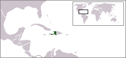
Haiti is located in the Caribbean. LocationHaiti.png
Haiti is located in the Caribbean.
2004 Haiti flood Haiti flood 1.jpg
2004 Haiti flood

There have been great challenges to the environment and biodiversity of Haiti. Deforestation in Haiti has left approximately 30% percent of forest cover at present.

Contents

Flora and fauna

Flamingo tongue on a purple sea fan from Arcadin Islands, Haiti. This sea snail is found living on various species of soft corals and sea fans. Flamingo tongue.jpg
Flamingo tongue on a purple sea fan from Arcadin Islands, Haiti. This sea snail is found living on various species of soft corals and sea fans.

The island of Hispaniola is home to more than 6,000 plants, of which 35% are endemic; and 220 species of birds. None of the birds are endemic to Haiti, but La Selle thrush is nearly so. The country's originally high biodiversity is due to its mountainous topography and fluctuating elevations in which each elevation harbors different microclimates. The country's varied scenery include lush green cloud forests (in some of the mountain ranges and the protected areas), high mountain peaks, arid desert, mangrove forest, and palm tree-lined beaches. [1] Since arrival of aboriginal man, the biodiversity of Haiti has been significantly diminished due to human exploitation. For example, the Caribbean monk seal, the only pinniped ever to occur in the Caribbean, is now extinct. [2]

Environmental hazards

In addition to soil erosion, deforestation in Haiti has caused periodic flooding, as seen on 17 September 2004. Tropical storm Jeanne skimmed the north coast of Haiti, leaving 3,006 people dead in flooding and mudslides, mostly in the city of Gonaïves. [3] Earlier that year in May, floods killed over 3,000 people on Haiti's southern border with the Dominican Republic. [4]

Haiti was again pummeled by tropical storms in late August and early September 2008. The storms—Tropical Storm Fay, Hurricanes Gustav, Hanna and Ike—all produced heavy winds and rain in Haiti. Due to weak soil conditions throughout Haiti, the country's mountainous terrain, and the devastating coincidence of four storms within less than four weeks, valley and lowland areas throughout the country experienced massive flooding. Casualties proved difficult to count because the storm diminished human capacity and physical resources for such record keeping. Bodies continued to surface as the flood waters receded. A 10 September 2008 source listed 331 dead and 800,000 in need of humanitarian aid. [5] The grim state of affairs produced by these storms was all the more life-threatening due to already high food and fuel prices that had caused a food crisis and political unrest in April 2008. [6]

As was the case in 2004, the coastal city of Gonaïves was hit especially hard by the 2008 storms.

There were also major problems in 1999 with hurricanes, leaving 9,398 dead, 10,000 injured and at least 5,000 missing.

Environmental issues

In 1925, Haiti was lush, with 60% of its original forest covering the lands and mountainous regions. Since then, recent in-depth study of satellite imagery has erroneously concluded an estimate of <1% primary forest cover. [7] Erosion has been severe in the mountainous areas. Most Haitian logging is done for agriculture and to produce charcoal, the country's chief source of fuel.

In the 19th century, arable land in the size of 15 hectares was distributed to farmers. It was inherited and divided by their children. In 1971, the average farm size was less than 1.5 hectares. To survive, the landowners had to overuse the land. It became infertile within a few years. The farmers moved to clear steeper hillsides and finally become unemployed. Eventually the shortage of arable land and rising rural poverty pushed peasants from hillside subsistence farms to search for work in Port-au-Prince, where the concentration of desperate people in slums contributed to the country's tragic history of civil strife. [8]

Despite the large environmental crises, Haiti retains a very high amount of biodiversity in proportion to its small size.

Water supply and sanitation

Haiti faces key challenges in the water supply and sanitation sector. Notably, access to public services is very low, their quality is inadequate and public institutions remain very weak despite foreign aid and the government's declared intent to strengthen the sector's institutions. Foreign and Haitian NGOs play an important role in the sector, especially in rural and urban slum areas.

See also

Related Research Articles

Geography of the Dominican Republic

The Dominican Republic is a country in the West Indies that occupies the eastern five-eighths of Hispaniola. It has an area of 48,670 km2, including offshore islands. The land border shared with Haiti, which occupies the western three-eighths of the island, is 376 km long. The maximum length, east to west, is 390 km from Punta de Agua to Las Lajas, on the border with Haiti. The maximum width, north to south, is 265 km from Cape Isabela to Cape Beata. The capital, Santo Domingo, is located on the south coast.

Deforestation Conversion of forest to non-forest for human use

Deforestation or forest clearance is the removal of a forest or stand of trees from land that is then converted to non-forest use. Deforestation can involve conversion of forest land to farms, ranches, or urban use. The most concentrated deforestation occurs in tropical rainforests. About 31% of Earth's land surface is covered by forests at present. This represents one-third less than the existing forest cover before the expansion of agriculture, a half of that loss occurring in the last century. Between 15 million to 18 million hectares of forest, an area the size of Belgium, are destroyed every year, on average 2,400 trees are cut down each minute. The Food and Agriculture Organization of the United Nations defines deforestation as the conversion of forest to other land uses. "Deforestation" and "forest area net change" are not the same: the latter is the sum of all forest losses (deforestation) and all forest gains in a given period. Net change, therefore, can be positive or negative, depending on whether gains exceed losses, or vice versa.

Geography of Haiti

The Republic of Haiti comprises the western three-eighths of the island of Hispaniola, west of the Dominican Republic. Haiti is positioned east of the neighboring island of Cuba, between the Caribbean Sea and the North Atlantic Ocean. Haiti's geographic coordinates are at a longitude of 72° 25′ west and a latitude of 19° 00′ north.

Geography of Honduras

Honduras is a country in Central America. Honduras borders the Caribbean Sea and the North Pacific Ocean. Guatemala lies to the west, Nicaragua south east and El Salvador to the south west. Honduras is the second largest Central American republic, with a total area of 112,890 square kilometres (43,590 sq mi).

Geography of Panama

Panama is a country located in Central America, bordering both the Caribbean Sea and the Pacific Ocean, between Colombia and Costa Rica. Panama is located on the narrow and low Isthmus of Panama.

Geography of Guatemala

Guatemala is mountainous, except for the south coastal area and the vast northern lowlands of Petén department. The country is located in Central America, bordering the Caribbean Sea, between Honduras and Belize and bordering the North Pacific Ocean, between El Salvador and Mexico. Two mountain chains enter Guatemala from west to east, dividing the country into three major regions: the highlands, where the mountains are located; the Pacific coast, south of the mountains; and the limestone plateau of the Petén region, north of the mountains. These areas vary in climate, elevation, and landscape, providing dramatic contrasts between hot and humid tropical lowlands and highland peaks and valleys.

Geography of East Timor

The geography of East Timor exhibits a mountainous terrain on the eastern half of the island of Timor in Southeast Asia. East Timor includes the eastern half of Timor, the Ocussi-Ambeno region on the northwest portion of the island of Timor, and the islands of Atauro and Jaco. The country is located northwest of Australia in the Lesser Sunda Islands at the eastern end of the Indonesian archipelago. 'Timor' is a Portuguese derivation of 'Timor', the Malay word for "Orient"; the island of Timor is part of the Malay Archipelago and is the largest and easternmost of the Lesser Sunda Islands. East Timor is the only Asian nation to lie entirely within the Southern Hemisphere. The Loes River is the longest with a length of 80 km (50 mi). This river system covers an area of 2,184 km2 (843 sq mi). It is a small country with a land size of 14,919 km2 (5,760 sq mi). The exclusive economic zone is 70,326 km2 (27,153 sq mi).

Gonaïves Commune in Artibonite, Haiti

Gonaïves is a commune in northern Haiti, and the capital of the Artibonite department of Haiti. It has a population of about 300,000 people.

Hurricane Jeanne Category 3 Atlantic hurricane in 2004

Hurricane Jeanne was a Category 3 hurricane that struck the Caribbean and the Eastern United States in September 2004. It was the deadliest hurricane in the Atlantic basin since Mitch in 1998. It was the tenth named storm, the seventh hurricane, and the fifth major hurricane of the season, as well as the third hurricane and fourth named storm of the season to make landfall in Florida. After wreaking havoc on Hispaniola, Jeanne struggled to reorganize, eventually strengthening and performing a complete loop over the open Atlantic. It headed westwards, strengthening into a Category 3 hurricane and passing over the islands of Great Abaco and Grand Bahama in the Bahamas on September 25. Jeanne made landfall later in the day in Florida just two miles from where Hurricane Frances had struck a mere three weeks earlier.

Tropical Storm Alpha (2005) Atlantic tropical storm

Tropical Storm Alpha was the 23rd tropical or subtropical storm of the extremely active 2005 Atlantic hurricane season. It developed from Tropical Depression Twenty-Five in the eastern Caribbean Sea on October 22, 2005. As the 21 pre-designated storm names had been exhausted, it was given the first name on the auxiliary list, which utilizes the letters of the Greek alphabet. This was the first hurricane season ever to trigger this naming protocol, and the only one until the 2020 season.

Environmental issues in Haiti

Environmental issues in Haiti include a historical deforestation problem, overpopulation, a lack of sanitation, natural disasters, and food insecurity. The major reasons for these environmental issues are corruption and human exploitation, and the embezzlement of taxpayers' funds for personal gains. In addition, there is not sufficient protection or management of the country's natural resources. Other environmental issues, such as decreases in precipitation and more severe natural disasters, will likely arise in Haiti as a result of climate change. Experts agree that Haiti needs to adopt new policies to address both the issues that already exist and to prepare for the effects of climate change.

Environmental issues in Indonesia

Environmental issues in Indonesia are associated with the country's high population density and rapid industrialisation, and they are often given a lower priority due to high poverty levels, and an under-resourced governance.

Hurricane Noel Category 1 Atlantic hurricane in 2007

Hurricane Noel was a deadly and very damaging tropical cyclone that carved a path of destruction across the Atlantic Ocean from the Caribbean Sea to Newfoundland in late October 2007. The sixteenth tropical depression, fourteenth named storm, and the sixth hurricane of the 2007 Atlantic hurricane season, Noel formed on October 27 from the interaction between a tropical wave and an upper-level low in the north-central Caribbean. It strengthened to winds of 60 mph (97 km/h) before making landfall on western Haiti and the north coast of eastern Cuba. Noel turned northward, and on November 1, it attained hurricane status. The hurricane accelerated northeastward after crossing the Bahamas, and on November 2, it transitioned into an extratropical cyclone.

Deforestation in Haiti Environmental problem

Deforestation in Haiti is a severe but complex and often misunderstood environmental problem. Haitians produce and consume charcoal as their primary source of domestic energy.

Hurricane Hanna (2008) Category 1 Atlantic hurricane in 2008

Hurricane Hanna was a moderately powerful but deadly tropical cyclone that caused extensive damage across the Western Atlantic, particularly in the Turks and Caicos Islands and the East Coast of the United States. The eighth named storm and fourth hurricane of the 2008 Atlantic hurricane season. It formed east-northeast of the northern Leeward Islands on August 28. Initially, the storm struggled to intensify due to moderate wind shear as it moved westwards towards the Bahamas. By August 31, Hanna had drifted southwards and began intensifying while over the Bahamas; it attained its peak intensity as a Category 1 hurricane while over the Turks and Caicos Islands. Due to the outflow of the nearby Hurricane Gustav, Hanna weakened back into a tropical storm the next day as it began to drift northwestwards towards the Southeastern United States. The storm struck Myrtle Beach, South Carolina, before moving up the Eastern Seaboard to become an extratropical cyclone as it moved by New England into Atlantic Canada early on September 7. The system raced across the North Atlantic, sweeping west of Great Britain on September 10 before turning north and becoming absorbed by a stronger extratropical cyclone between Iceland and Greenland late on September 12.

Mangrove restoration is the regeneration of mangrove forest ecosystems in areas where they have previously existed. The practice of mangrove restoration is grounded in the discipline of restoration ecology, which aims to “[assist] the recovery of resilience and adaptive capacity of ecosystems that have been degraded, damaged, or destroyed”. Since environmental impacts are an ongoing threat, to successfully restore an ecosystem implies not merely to recreate its former condition, but to strengthen its capacity to adapt to change over time. Mangrove forests are most likely to thrive in the upper half of the intertidal zone. If planted below the mean tide level, or subject to too great a sea level rise, they may fail to thrive. Success will also depend on the species chosen and their suitability to conditions.

Wildlife of Haiti

The wildlife of Haiti is important to the country because of its biodiversity. According to the World Conservation Monitoring Centre, Haiti is considered to be "one of the most biologically significant countries of the West Indies". With an estimated 5,600 plant species on the island of Hispaniola, some of which only occur in Haiti, 36% are considered as endemic to the island. A mountainous area country, it is situated in the western three-eighths of Hispaniola and shares a border with the Dominican Republic. There are nine life zones, from low desert to high cloud forests, as well as four mountain ranges, and hundreds of rivers and streams and the coral reefs in the seas that surround the islands. Issues of environmental damage, expanding population, deforesting and erosion are of concern; less than 2% of the original forest remains on account of deforestation. This degradation is traced from the 17th century to 19th century starting with the French colonization of the Haiti and population explosion during the 20th century and for the purpose of forestry and sugar-related industries, degraded the forests. and the environment.

Eden Reforestation Projects

Eden Reforestation Projects is a nonprofit organization that works in developing countries to rebuild natural landscapes destroyed by deforestation. Eden works directly with villages and communities suffering from extreme poverty resulting from the deforestation and destruction of the land that sustains them. The organization employs thousands of local villagers and provides them with the education and tools necessary to plant, grow, and protect to maturity, millions of trees each year. Eden currently plants approximately 15 million additional trees a month, and in 2020 reached over 423 million trees planted of which over 225 million are mangrove trees.

Effects of Hurricane Dennis in Haiti

In early July 2005, Hurricane Dennis brushed the southern coast of Haiti and produced deadly flash flooding across the nation. Forming from a tropical depression on July 4, Dennis began impacting Haiti two days later with heavy rains. Civil authorities and international agencies acted quickly to protect lives, ordering evacuations—approximately 1,000 people complied—and prepositioning emergency supplies. Over the subsequent two days, the hurricane's outer bands continued to impact the nation before effects abated. Widespread flash floods and landslides caused substantial damage, with areas along the Tiburon Peninsula taking the brunt of the impact. A bridge collapse near Grand-Goâve left 15 people dead or missing.

Hurricanes in Hispaniola Wikipedia list article

Hispaniola is an island in the Caribbean, with the second largest size throughout all of the Caribbean. Throughout the centuries, since reliable records began, hundreds of hurricanes and tropical cyclones have affected Haiti and the Dominican Republic, the two countries that share the island. The most recent tropical cyclone to affect Hispaniola was Tropical Storm Grace in August 2021.

References

  1. Kiskeya Alternative http://kiskeya-alternative.org. "Can Haiti dream of ecotourism ? - Paul Parisky, Kiskeya Alternativa's publications". Kiskeya-alternative.org. Retrieved 2010-01-14.
  2. Peter Saundry. 2010. Caribbean monk seal. Encyclopedia of Earth. eds. C.Michael Hogan and Cutler Cleveland. National council for Science and the Environment, Washington DC
  3. "Photo Gallery: Jeanne hits Haiti". Orlando Sentinel. Retrieved 2006-09-18.
  4. "Deforestation Exacerbates Haiti Floods". Globalexchange.org. Archived from the original on 2010-01-17. Retrieved 2010-01-14.
  5. "UN seeks almost $108 million for Haiti floods" . Retrieved 2008-09-12.[ dead link ]
  6. "Haiti's government falls after food riots". Reuters. 2008-04-13. Retrieved 2008-09-12.
  7. Hedges SB, Cohen WB, Timyan J, Yang Z. 2018. Haiti's biodiversity threatened by nearly complete loss of primary forest. Proc. Natl. Acad Sci. USA. 115(46):11850-11855
  8. David R. Montgomery, Dirt. The Erosion of Civilizations, Berkeley: University of California Press 2007. Pages 227-230.

Further reading