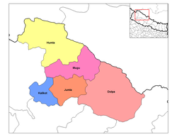
Rapti Zone was one of the fourteen zones, located in the Mid-Western Development Region of Nepal. It was named after the West Rapti River which drains Rolpa, Pyuthan and part of Dang districts. The remainder of Dang and part of Salyan district are drained by the Babai. The remainder of Salyan and all of Rukum districts are drained by the Bheri.
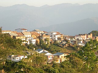
Dhankuta is a hill town and the headquarters of Dhankuta District in Koshi Province in Eastern Nepal. According to 2011 Nepal census, it has population of 26,440 inhabitants.

The Terai or Tarai is a lowland region in parts of southern Nepal and northern India that lies to the south of the outer foothills of the Himalayas, the Sivalik Hills and north of the Indo-Gangetic Plain. This lowland belt is characterised by tall grasslands, scrub savannah, sal forests and clay rich swamps. In North India, the Terai spreads from the Yamuna River eastward across Haryana, Uttarakhand, Uttar Pradesh, Bihar and West Bengal. The Terai is part of the Terai-Duar savanna and grasslands ecoregion. Nepal's Terai stretches over 33,998.8 km2 (13,127.0 sq mi), about 23.1% of Nepal's land area, and lies at an elevation of between 67 and 300 m. The region comprises more than 50 wetlands. North of the Terai rises the Bhabar, a narrow but continuous belt of forest about 8–12 km (5.0–7.5 mi) wide.

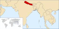
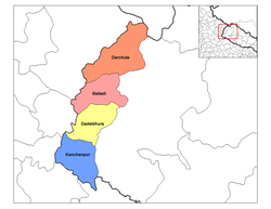
Mahakali was one of the fourteen zones located in the Far-Western Development Region of Nepal, covering an area of 6,205 km2 in the westernmost part of the country. It stretches along Nepal's far western border with India, marked by the Kali River or Mahakali River.

Dhankuta District is one of 14 districts of Koshi Province of eastern Nepal. The district covers an area of 891 km2 (344 sq mi) and has a population (2011) of 163,412. The hill town of Dhankuta serves as the district headquarters of Dhankuta District.
Kanchanpur District, a part of Sudurpashchim Province in the Terai plain, is one of seventy-seven districts of Nepal. The district, with Bhimdatta as its district headquarters, covers an area of 1,610 square kilometres (620 sq mi) and had a population of 134,868 in 2001 and 171,304 in 2011. It is located in south-western of Nepal. It is bordered by Kailali district in the east, Dadeldhura district in the north and with India in the south and west.

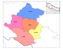
Rukum District was a "hills" and "mountains" district some 280 km (170 mi) west of Kathmandu partially belonging to Lumbini Province and partially to Karnali Province before split into two districts Western Rukum and Eastern Rukum after the state's reconstruction of administrative divisions in 2017. Rukum covers an area of 2,877 km2 (1,111 sq mi) with population of 207,290 in 2011 Nepal census. Musikot was the district's administrative center.

Salyan District IPA: [sʌljan], in Karnali Province, is one of the seventy-seven districts of Nepal. Salyan covers an area of 1,462 km2 (564 sq mi) with a population of 213,500 in 2001 and 241,716 in 2011. The district's administrative center is named Salyan or Salyan Khalanga, today it is part of Shaarada Municipality.

Solukhumbu District (Nepali: सोलुखुम्बु जिल्ला, Sherpa: ཤར་ཁུམ་བུ་རྫོང་།, Wylie: shar khum bu dzong) is one of 14 districts of Koshi Province of eastern Nepal. As the name suggests, it consists of the sub-regions Solu and Khumbu. The closest post office to Solukhumbu with a postal code assigned to it is the Sindhuli D.P.O., which has the postal code 56000.

Udayapur District (Nepali: उदयपुर जिल्ला, is one of the 14 districts of Koshi Province in eastern Nepal. The district, with Triyuga as its district headquarters, covers an area of 2,063 km2 and in 2001 had a population of 287,689, in 2011 of 317,532, in 2021 of 342,773
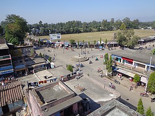
Pyuthan is a municipality in the Pyuthan District in the Lumbini Province of Nepal. This municipality is named after the district name Pyuthan. It is also the major market center and the administrative center of district. The municipality was established on 18 May 2014 by merging the existing VDCs Khaira, Dakha Kwadi, Bijaya Nagar, Bijuwar, Dharmawati, Maranthana and Khalanga village development committees. In 2017, when GoN restructured the local level bodies into 753 units, Pyuthan Municipality was also restructured excluding ward no. 1, 2, 3, 5 and 18 from old structure, further two other VDCs; Majhkot and Jumrikanda added, Khalanga separated and managed the municipality into 10 new wards. Nayabajar Jumri and Bijuwar are the major markets of Pyuthan Municipality.
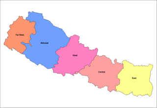
Prior to the promulgation of a new constitution in 2015 after an earthquake, Nepal was divided into five development regions, 14 administrative zones and 75 districts. The 14 administrative zones were grouped into five development regions. Each district is headed by a Chief District Officer (CDO) responsible for maintaining law and order and coordinating the work of field agencies of the various government ministries.
Bhumlichok is a village development committee in Gorkha District in the Gandaki Zone of northern-central Nepal. At the time of the 1991 Nepal census it had a population of 2,964 and had 518 houses in the town.

The Eastern Development Region was one of Nepal's five development regions. It is also known as Kirata region. It was located at the eastern end of the country with its headquarters at Dhankuta. The town of Dhankuta was the headquarter of the Eastern Region, as well as the headquarter of the Dhankuta District.
Phakchamara is a village development committee in the Himalayas of Terhathum District in the Kosi Zone of eastern Nepal. At the time of the 1991 Nepal census it had a population of 3041. Brahmin, Chhetri, and Limbu are the main cast of this VDC. Naween Shikshya Sadan Higher Secondary School is the oldest School of this region as well as of this VDC. Several philanthropists contribute to the educational development of this VDC through this school. Mr. Krishna Prasad Dahal was a long time "Head sir" of this school and significantly contributed to the local society for uplifting the educational levels of numerous people of this region. "Dahal" and "Niroula" families contributions are tremendous for the development of this region and of this VDC. Currently, under new reformation of the political system in Nepal, it is included within "Chhathar VDC Ward No. 4". The Chhathar VDC chair after the election on 2017 is Santosh Tigela from Communist Party of Nepal. The only road that connects this region to Teria and accessible municipalities like Dhankuta and Dharan is by "Sindhuwa Sukrabare Road". The construction of this 8 km road has been started in 1986 but not pitched and completed yet due to corruption and idiot leaders. "Sukrabare bazaar" is the major business hub of this region. Buses and private vehicles are now run in this road 12 months after the graveling of the road in 2019. This is beautiful VDC with a pristine panorama of "KumbhaKarna Mountain" and a silver lining shine of Tamor River. Rhododendroen is everywhere mostly in the higher region. Water crises, foreign employment are the major problems. The Upper regions which are mostly wetland should be protected and initiate aforestation for the future of this VDC.

Pakhribas is an urban municipality that is one of three urban municipalities located in Dhankuta District of Province No. 1 of Nepal. The municipality was established on 2 December 2014 as a merger of the VDCs of Pakhribas, Sanne, Phalate, Ghorlikharka and Muga.

Koshi Province is the autonomous easternmost province adopted by the Constitution of Nepal on 20 September 2015. The province is rich in natural resources, tourist attractions, recreational activities, and natural beauty. The province covers an area of 25,905 km2 (10,002 sq mi), about 17.5% of the country's total area. With the industrial city of Biratnagar as its capital, the province includes major eastern towns of Birtamod, Sundar Haraincha, Damak, Dharan, Itahari, Triyuga Municipality and Mechinagar, and the Mount Everest, Kangchenjunga and Ama Dablam. Koshi River, the largest river of the nation, forms the province's western boundary. Under the First-past-the-post voting system issued by the Constituency Delimitation Commission, Nepal, the province hosts 28 parliamentary seats and 56 provincial assembly seats.

Sudurpashchim Province is one of the seven provinces established by the new constitution of Nepal which was adopted on 20 September 2015. It borders the Tibet Autonomous Region of China to the north, Karnali Province and Lumbini Province to the east, and India's states of Uttarakhand and Uttar Pradesh to the west and south, respectively. The province covers an area of 19,999.28 km2, or about 13.55% of the country's total area.

Byas is a rural municipality located in Darchula District of Sudurpashchim Province of Nepal.