Marietta is a city in and the county seat of Washington County, Ohio, United States. It is located in southeastern Ohio at the confluence of the Muskingum and Ohio Rivers, 11 miles (18 km) northeast of Parkersburg, West Virginia. As of the 2020 census, Marietta has a population of 13,385 people. It is the principal city of the Marietta micropolitan area, which includes all of Washington County, and is the second-largest city in the Parkersburg–Marietta–Vienna combined statistical area.
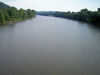
The Muskingum River is a tributary of the Ohio River, approximately 111 miles (179 km) long, in southeastern Ohio in the United States. An important commercial route in the 19th century, it flows generally southward through the eastern hill country of Ohio. Via the Ohio, it is part of the Mississippi River watershed. The river is navigable for much of its length through a series of locks and dams.

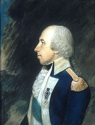
Josiah Harmar was an officer in the United States Army during the American Revolutionary War and the Northwest Indian War. He was the senior officer in the Army for six years and seven months.

The Northwest Territory, also known as the Old Northwest and formally known as the Territory Northwest of the River Ohio, was formed from unorganized western territory of the United States after the American Revolution. Established in 1787 by the Congress of the Confederation through the Northwest Ordinance, it was the nation's first post-colonial organized incorporated territory.
Rufus Putnam was an American military officer who fought during the French and Indian War and the American Revolutionary War. As an organizer of the Ohio Company of Associates, he was instrumental in the initial colonization by the United States of former Native American, English, and French lands in the Northwest Territory in present-day Ohio following the war.

The Treaty of Fort Harmar (1789) was a treaty made between the United States and the Haudenosaunee, Ojibwe, Odawa, Potawatomi, Sauk, Wyandot, and Lenape, all Indigenous nations with territorial claims within the European land claim acquired in 1783 by the United States from the Kingdom of Great Britain known as the Northwest Territory.

The Big Bottom massacre was a mass killing perpetrated by Lenape and Wyandot warriors against American settlers on January 2, 1791. The massacre occurred near present-day Stockport, Ohio. It is considered part of the Northwest Indian Wars, in which native Americans in the Ohio Country clashed with American settlers, seeking to expel them from their territory.
Paul Fearing was an American politician who served as a delegate to the United States House of Representatives from the Northwest Territory.

Fort Washington was a fortified stockade with blockhouses built by order of Gen. Josiah Harmar starting in summer 1789 in what is now downtown Cincinnati, Ohio, near the Ohio River. The physical location of the fort was facing the mouth of the Licking River, above present day Fort Washington Way. The fort was named in honor of President George Washington. The fort was the major staging place and conduit for settlers, troops and supplies during the settlement of the Northwest Territory.
William Stacy was an officer of the Continental Army during the American Revolutionary War, and a pioneer to the Ohio Country. Published histories describe Colonel William Stacy's involvement in a variety of events during the war, such as rallying the militia on a village common in Massachusetts, participating in the Siege of Boston, being captured by Loyalists and American Indians at the Cherry Valley massacre, narrowly escaping a death by burning at the stake, General George Washington's efforts to obtain Stacy's release from captivity, and Washington's gift of a gold snuff box to Stacy at the end of the war.

Benjamin Tupper was an American soldier in the French and Indian War, and an officer of the Continental Army during the American Revolutionary War, achieving the rank of brevet brigadier general. Subsequently, he served as a Massachusetts legislator, and he assisted Gen. William Shepard in stopping Shays' Rebellion. Benjamin Tupper was a co-founder of the Ohio Company of Associates, and was a pioneer to the Ohio Country, involved in establishing Marietta as the first permanent settlement in the Northwest Territory.
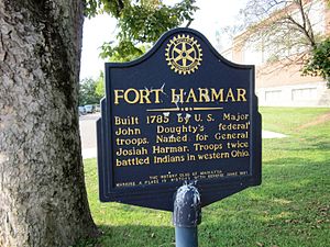
Harmar is a historic neighborhood in the city of Marietta, Ohio, United States. Located at the western side of the confluence of the Muskingum and Ohio Rivers, it grew up around the early Fort Harmar in the 1780s, being settled in conjunction with Marietta. After a period of forming part of Marietta, it existed separately beginning in 1837 before rejoining the mother city in 1890. Connected by bridge to the rest of the city, it retains much of its nineteenth-century architecture and landscape, and most of the neighborhood is now a historic district on the National Register of Historic Places.
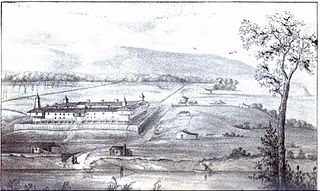
Campus Martius was a defensive fortification at the Marietta, Ohio settlement. It was home to Rufus Putnam, Benjamin Tupper, Arthur St. Clair, and other pioneers from the Ohio Company of Associates during the Northwest Indian War. Major Anselm Tupper was commander of the Campus Martius during the war. Construction began in 1788 and was fully completed in 1791. The Campus Martius was located on the east side of the Muskingum River and upriver from its confluence with the Ohio River. A firsthand description of the fort is provided in Hildreth's Pioneer History,
Campus Martius is the most handsome pile of buildings on this side of the Alleghany mountains, and in a few days, it will be the strongest fortification in the territory of the United States. It stands on the margin of the elevated plain on which are the remains of the ancient works [mounds], mentioned in my letter of May last, thirty feet above the high bank of the Muskingum, twenty-nine perches distant from the river, and two hundred and seventy-six from the Ohio. It consists of a regular square, with a block house at each angle, eighteen feet square on the ground, and two stories high; the upper story is on the outside or face, jutting over the lower one, eighteen inches. These blockhouses serve as bastions to a regular fortification of four sides. The curtains comprise dwelling houses two stories high, eighteen feet wide, and of different lengths.

Picketed Point Stockade was the last of three fortifications built at Marietta, Ohio. This defensive stockade was built by pioneers during the Northwest Indian War in 1791 on the east side of the mouth of the Muskingum River at its confluence with the Ohio River, and directly across the Muskingum from Fort Harmar. Colonel William Stacy superintended the construction of the stockade under direction of Colonel Ebenezer Sproat. Palisades or pickets were set from the Muskingum River eastward, meeting in the northeast corner of the fortification with another line of pickets built from the Ohio River northward, enclosing about four acres.
Three block houses were immediately built: one on the Muskingum bank, at the western termination of the pickets; one in the northeast corner of the inclosure; and one on the Ohio bank. Near to the latter, and by that on the Muskingum, were strong gates, of a size to admit teams, the approaches to which were commanded by the block houses. These block houses were surmounted by sentry boxes, or turrets, the sides of which were secured with thick planks for the defense of the men when on guard.

Anselm Tupper was an officer of the Continental Army during the American Revolutionary War, a pioneer to the Ohio Country, and one of the founders of Marietta, Ohio, the first permanent American settlement in the Northwest Territory. The eldest son of Benjamin Tupper, Anselm enlisted in the fight for independence during 1775, while only eleven years old, achieving the rank of lieutenant before his seventeenth birthday. After the war, he was a pioneer and surveyor in the Northwest Territory, and became major of the militia at Marietta during the Northwest Indian War. Tupper was the first school teacher at Marietta, and was a classical scholar and poet. He was unmarried, and was known as a favorite in society.

Ebenezer Sproat, surname also spelled Sprout, was an officer of the Continental Army during the American Revolutionary War, a pioneer to the Ohio Country, and one of the founders of Marietta, Ohio, the first permanent American settlement in the Northwest Territory. He served throughout the entire American war of independence, from April 1775 through November 1783, achieving the rank of colonel. After the war, he was a pioneer and surveyor in the Northwest Territory, and became a leader of the militia at Marietta during the Northwest Indian War. He was the first sheriff in the Northwest Territory and Ohio, serving fourteen years as sheriff of Washington County, the oldest county in Ohio.

Fort Steuben was a fortification erected in Feb. 1787 on the Ohio River in eastern Ohio Country at the northern end of the Seven Ranges land tract to be surveyed. It was at the location of the modern city of Steubenville, Ohio. The fort was built by Major John Hamtramck and named for Friedrich Wilhelm von Steuben, a Prussian army officer who had served under General Washington. The original purpose was to provide protection from Indians for the first surveyors to venture into the Northwest Territory.

Farmer's Castle was a defensive fortification built opposite the mouth of the Little Kanawha River on the Ohio River by a group of pioneers from the Ohio Company of Associates. It was located about 15 miles downriver of Marietta, Ohio, the first European-American settlement in the Northwest Territory. The pioneers had surveyed the land during the winter of 1788-89, and moved from Marietta to their new farms in April 1789. They called their town Belle-prairie, or modern day Belpre, Ohio. Adjacent to the island later known as Blennerhasset Island, the settlers began construction of Farmer's Castle during January 1791 for protection during the Northwest Indian War.
The work was commenced the first week in January, and was prosecuted with the utmost energy, as their lives, apparently, depended on its completion. As fast as the block houses were built, the families moved into them. They were thirteen in number, arranged in two rows, with a wide street between, as shown in the engraving. The basement story was in general twenty feet square, and the upper about twenty-two feet, thus projecting over the lower one, and forming a defense from which to protect the doors and windows below, in an attack. They were built of round logs a foot in diameter, and the interstices nicely chinked and pointed with mortar. The doors and window shutters were made of thick oak planks, or puncheons, and secured with stout bars of wood on the inside. The larger timbers were hauled with ox-teams, of which they had several yokes, while the lighter for the roofs, gates, &c, were dragged along on hand sleds, with ropes, by the men. The drawing was much facilitated by a few inches of snow, which covered the ground. The pickets were made of quartered oak timber, growing on the plain back of the garrison, formed from trees about a foot in diameter, fourteen feet in length, and set four feet deep in the ground, leaving them ten feet high, over which no enemy could mount without a ladder. The smooth side was set outward, and the palisades strengthened and kept in their places by stout ribbons, or wall pieces, pinned to them with inch treenails on the inside. The spaces between the houses were filled up with pickets, and occupied three or four times the width of the houses, forming a continuous wall, or inclosure, about eighty rods in length and six rods wide. The palisades on the river side filled the whole space, and projected over the edge of the bank, leaning on rails and posts set to support them. They were sloped in this manner for the admission of air during the heat of summer.

Fort Frye was a triangular defensive fortification built by a group of pioneers from the Ohio Company of Associates who moved about twenty miles up the Muskingum River from the settlement of Marietta, Ohio to a location near the mouth of Wolf Creek. During 1789 the pioneers established settlements now known as Waterford and Beverly on the southwest and northeast banks of the Muskingum, respectively. The settlements were located about 13 miles downriver from a small group of pioneers at Big Bottom. During January and February 1791, following the massacre at Big Bottom and the start of the Northwest Indian War, the settlers built Fort Frye at Beverly.
The form of the fort was triangular, which is rather uncommon in military defenses. But as they were in a hurry, and it saved them one line of curtains, while the block houses at the angles defended the sides just as well as in any other form, it was adopted. The base of the triangle rested on the river, distant only a few paces from the bank, and was about two hundred feet in length. One of the other sides was somewhat longer, so that the work was not a regular triangle. At each corner, was a two story block house, twenty feet square below, and a foot or two more above. The two longer sides were filled in with dwelling houses, some of which were two stories high, and others of a lesser height, while a considerable portion were built barrack fashion, with only one roof, pitched inward, so that the rain from it fell within the garrison. The spaces not occupied by buildings were filled in with stout pickets. Broad, substantial gates, near the northern block house, led out through the palisades into the highway and fields, while a smaller one in the curtain on the bank, called the water gate, afforded an opening to the river. A line of palisades, twelve feet high, at the distance of thirty feet, inclosed the whole, and descended to the river.