Friendship, Wisconsin

Last updated
There is also the Town of Friendship in Fond du Lac County.
Friendship, Wisconsin
Friendship Wisconsin Looking North WIS 13.jpg
Looking north in downtown Friendship on WIS 13
Adams County Wisconsin Incorporated and Unincorporated areas Friendship Highlighted.svg
Location of Friendship in Adams County, Wisconsin.
USA Wisconsin location map.svg
Red pog.svg
Friendship
Location of Friendship in Adams County, Wisconsin.
Usa edcp location map.svg
Red pog.svg
Friendship
Friendship (the United States)
Coordinates: 43°58′18″N89°49′7″W / 43.97167°N 89.81861°W / 43.97167; -89.81861 Coordinates: 43°58′18″N89°49′7″W / 43.97167°N 89.81861°W / 43.97167; -89.81861
Country Flag of the United States.svg  United States
State Flag of Wisconsin.svg  Wisconsin
County Adams
Area
[1]
  Total0.94 sq mi (2.45 km2)
  Land0.90 sq mi (2.33 km2)
  Water0.04 sq mi (0.11 km2)
Elevation
[2]
955 ft (291 m)
Population
 (2010) [3]
  Total725
  Estimate 
(2018) [4]
674
  Density748.89/sq mi (289.13/km2)
Time zone UTC-6 (Central (CST))
  Summer (DST) UTC-5 (CDT)
ZIP code
53934
Area code(s) 608
FIPS code 55-27950 [5]
GNIS feature ID1565329 [2]
Website www.adamsfriendship.com
Friendship Mound Friendshipmound.JPG
Friendship Mound

Friendship is a village in Adams County in the U.S. state of Wisconsin. It is the county seat of Adams County. The population was 725 at the 2010 census.

Contents

Geology

The Friendship Mound sits just to the north of town. It is a castillated mound formed from the last glaciers to cover the area during the Ice Age. Another mound, Roche-A-Cri, is a few miles north of the village in Roche-A-Cri State Park. That mound contains the Roche-A-Cri Petroglyphs.

Geography

Friendship is located at 43°58′18″N89°49′7″W / 43.97167°N 89.81861°W / 43.97167; -89.81861 (43.971758, -89.818718). [6]

According to the United States Census Bureau, the village has a total area of 0.92 square miles (2.38 km2), of which, 0.88 square miles (2.28 km2) of it is land and 0.04 square miles (0.10 km2) is water. [7]

Demographics

Historical population
CensusPop.
1870 76
1880 13780.3%
1890 15613.9%
1910 276
1920 44260.1%
1930 438−0.9%
1940 4533.4%
1950 56624.9%
1960 560−1.1%
1970 64114.5%
1980 74416.1%
1990 728−2.2%
2000 698−4.1%
2010 7253.9%
Est. 2018674 [4] −7.0%
U.S. Decennial Census [8]

2010 census

As of the census [3] of 2010, there were 725 people, 256 households, and 161 families living in the village. The population density was 823.9 inhabitants per square mile (318.1/km2). There were 323 housing units at an average density of 367.0 per square mile (141.7/km2). The racial makeup of the village was 95.0% White, 1.9% African American, 0.1% Native American, 0.6% Asian, 1.5% from other races, and 0.8% from two or more races. Hispanic or Latino of any race were 4.0% of the population.

There were 256 households of which 28.9% had children under the age of 18 living with them, 41.4% were married couples living together, 15.6% had a female householder with no husband present, 5.9% had a male householder with no wife present, and 37.1% were non-families. 32.8% of all households were made up of individuals and 14.5% had someone living alone who was 65 years of age or older. The average household size was 2.29 and the average family size was 2.81.

The median age in the village was 45.6 years. 18.5% of residents were under the age of 18; 8.4% were between the ages of 18 and 24; 22.2% were from 25 to 44; 23.8% were from 45 to 64; and 27% were 65 years of age or older. The gender makeup of the village was 50.2% male and 49.8% female.

2000 census

As of the census [5] of 2000, there were 698 people, 257 households, and 157 families living in the village. The population density was 787.4 people per square mile (302.8/km²). There were 294 housing units at an average density of 331.7 per square mile (127.5/km²). The racial makeup of the village was 94.27% White, 0.43% African American, 1.72% Native American, 2.15% Asian, 0.14% Pacific Islander, 0.57% from other races, and 0.72% from two or more races. Hispanic or Latino of any race were 1.15% of the population.

There were 257 households out of which 29.2% had children under the age of 18 living with them, 44.0% were married couples living together, 10.9% had a female householder with no husband present, and 38.9% were non-families. 34.2% of all households were made up of individuals and 19.5% had someone living alone who was 65 years of age or older. The average household size was 2.31 and the average family size was 2.97.

In the village, the population was spread out with 24.1% under the age of 18, 7.0% from 18 to 24, 27.7% from 25 to 44, 18.9% from 45 to 64, and 22.3% who were 65 years of age or older. The median age was 40 years. For every 100 females, there were 105.3 males. For every 100 females age 18 and over, there were 109.5 males.

The median income for a household in the village was $24,615, and the median income for a family was $33,438. Males had a median income of $29,375 versus $21,458 for females. The per capita income for the village was $14,773. About 16.4% of families and 23.4% of the population were below the poverty line, including 38.8% of those under age 18 and 10.3% of those age 65 or over.

Transportation

Adams County Airport (63C) serves Friendship and the surrounding communities.

Notable people

Buildings, sites, structures, districts, and objects in Friendship listed on the National Register of Historic Places

Images

Related Research Articles

Adams County, Ohio U.S. county in Ohio

Adams County is a county in the U.S. state of Ohio. As of the 2010 census, the population was 28,550. Its county seat is West Union. The county is named after John Adams, the second President of the United States.

Naknek, Alaska CDP/borough seat in Alaska, United States

Naknek is a census-designated place located in and the borough seat of Bristol Bay Borough in the U.S. state of Alaska. As of the 2010 census, the population of the CDP was 544, down from 678 in 2000.

Glacier View, Alaska CDP in Alaska, United States

Glacier View is a census-designated place (CDP) in Matanuska-Susitna Borough, Alaska, United States. It is part of the Anchorage, Alaska Metropolitan Statistical Area. At the 2010 census the population was 234, down from 249 in 2000. The terminus of Matanuska Glacier is located approximately three miles southwest of Glacier View.

Yalaha, Florida Census-designated place in Florida

Yalaha is an unincorporated area and census-designated place (CDP) in Lake County, Florida, United States. The population was 1,364 at the 2010 census, up from 1,175 at the 2000 census. It is part of the Orlando–Kissimmee Metropolitan Statistical Area.

Unionville, Iowa City in Iowa, United States

Unionville is a city in Appanoose County, Iowa, United States. The population was 102 at the 2010 census.

Halbur, Iowa City in Iowa, United States

Halbur is a city in Carroll County, Iowa, United States. The population was 246 at the 2010 census.

Mound, Louisiana Village in Louisiana, United States

Mound is a village in Madison Parish, Louisiana, United States. The population was 12 at the 2000 census. Its ZIP Code is 71282.

Brunswick, Nebraska Village in Nebraska, United States

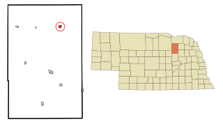
Brunswick is a village in Antelope County, Nebraska, United States. The population was 138 at the 2010 census.

Zeeland, North Dakota City in North Dakota, United States

Zeeland is a city in McIntosh County, North Dakota in the United States. The population was 86 at the 2010 census.

Tarlton, Ohio Village in Ohio, United States

Tarlton is a village in Fairfield and Pickaway counties in the U.S. state of Ohio. The population was 282 at the 2010 census.

West Farmington, Ohio Village in Ohio, United States

West Farmington is a village in Trumbull County, Ohio, United States, along the Grand River. The population was 499 at the 2010 census. It is part of the Youngstown-Warren-Boardman, OH-PA Metropolitan Statistical Area.

Zaleski, Ohio Village in Ohio, United States

Zaleski is a village in Vinton County, Ohio, United States. The population was 278 at the 2010 census.

West Salem, Ohio Village in Ohio, United States

West Salem is a village in Wayne County, Ohio, United States. The population was 1,464 at the 2010 census. West Salem is served by a branch of the Wayne County Public Library. The noted drag racing track Dragway 42 is located nearby.

McEwensville, Pennsylvania Borough in Pennsylvania, United States

McEwensville is a borough in Northumberland County, Pennsylvania, United States. The population was 314 at the 2000 census.

Basye, Virginia CDP in Virginia, United States

Basye is a census-designated place (CDP) in Shenandoah County, Virginia, United States. The population was 1,253 at the 2010 census, an increase from 986 at the 2000 census, when the CDP was known as Basye-Bryce Mountain.

Holden, West Virginia CDP in West Virginia, United States

Holden is a census-designated place (CDP) in Logan County, West Virginia, United States. The population was 876 at the 2010 census.

Preston, Adams County, Wisconsin Town in Wisconsin, United States

Preston is a town in Adams County in the U.S. state of Wisconsin. The population was 1,393 at the 2010 census. The unincorporated community of Cottonville is located in the town. The ghost towns of Fordham and Roche a Cri were also located in the town.

Friendship is a town in Fond du Lac County, Wisconsin, United States. The population was 2,406 at the 2000 census. The unincorporated communities of Dexter and Van Dyne are located within the town.

Adams, Wisconsin City in Wisconsin, United States

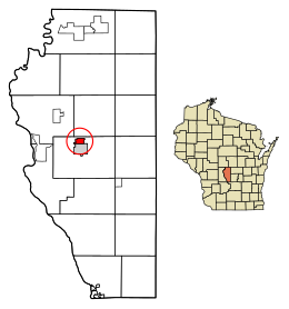
Adams is a city in Adams County in the U.S. state of Wisconsin. The population was 1,967 at the 2010 census. The city is located within the Town of Adams.

Blue Mounds, Wisconsin Village in Wisconsin, United States

Blue Mounds is a village in Dane County, Wisconsin, United States. As of the 2010 census, the village had a population of 855. The village is adjacent to the Town of Blue Mounds, and is part of the Madison Metropolitan Statistical Area.

References

  1. "2018 U.S. Gazetteer Files". United States Census Bureau. Retrieved Feb 15, 2020.
  2. 1 2 "US Board on Geographic Names". United States Geological Survey. 2007-10-25. Retrieved 2008-01-31.
  3. 1 2 "American FactFinder". United States Census Bureau. Archived from the original on 2020-02-12. Retrieved 2012-11-18.
  4. 1 2 "Population and Housing Unit Estimates" . Retrieved June 4, 2019.
  5. 1 2 "American FactFinder". United States Census Bureau. Archived from the original on 2020-02-12. Retrieved 2008-01-31.
  6. "US Gazetteer files: 2010, 2000, and 1990". United States Census Bureau. 2011-02-12. Retrieved 2011-04-23.
  7. "US Gazetteer files 2010". United States Census Bureau. Archived from the original on 2012-07-02. Retrieved 2012-11-18.
  8. "Census of Population and Housing". Census.gov. Archived from the original on April 26, 2015. Retrieved June 4, 2015.