Georgetown, Polk County, Wisconsin

Last updated

Georgetown, Wisconsin
WIMap-doton-Georgetown.png
Location of Georgetown, Polk County, Wisconsin
Coordinates: 45°30′43″N92°20′47″W / 45.51194°N 92.34639°W / 45.51194; -92.34639
Country Flag of the United States.svg  United States
State Flag of Wisconsin.svg  Wisconsin
County Polk
Area
  Total35.2 sq mi (91.1 km2)
  Land30.3 sq mi (78.6 km2)
  Water4.8 sq mi (12.5 km2)
Elevation
[1]
1,178 ft (359 m)
Population
 (2000)
  Total977
  Density32.2/sq mi (12.4/km2)
Time zone UTC-6 (Central (CST))
  Summer (DST) UTC-5 (CDT)
Area code(s) 715 & 534
FIPS code 55-28725 [2]
GNIS feature ID1583265 [1]
Website https://townofgeorgetownwi.com/

Georgetown is a town in Polk County, Wisconsin, United States. The population was 977 at the 2010 census. The unincorporated communities of Bunyan and Fox Creek are located in the town.

Contents

Geography

According to the United States Census Bureau, the town has a total area of 35.2 square miles (91.1 km2), of which, 30.3 square miles (78.6 km2) of it is land and 4.8 square miles (12.5 km2) of it (13.71%) is water.

Demographics

As of the census [2] of 2010, there were 977 people, 433 households, and 299 families residing in the town. The U.S. Census Bureau projects Georgetown's population will be 1151 in 2010. The population density was 33.1 people per square mile (12.8/km2). There were 1,274 housing units at an average density of 42.0 per square mile (16.2/km2). The racial makeup of the town was 90.44% White, 9.06% Native American, 0.20% Asian, and 0.30% from two or more races. Hispanic or Latino of any race were 0.50% of the population.

There were 433 households, out of which 26.8% had children under the age of 18 living with them, 57.0% were married couples living together, 8.5% had a female householder with no husband present, and 30.9% were non-families. 27.3% of all households were made up of individuals, and 13.9% had someone living alone who was 65 years of age or older. The average household size was 2.32 and the average family size was 2.77.

In the town, the population was spread out, with 22.7% under the age of 18, 4.8% from 18 to 24, 21.2% from 25 to 44, 32.4% from 45 to 64, and 18.9% who were 65 years of age or older. The median age was 46 years. For every 100 females, there were 108.7 males. For every 100 females age 18 and over, there were 103.1 males.

The median income for a household in the town was $38,487, and the median income for a family was $44,722. Males had a median income of $37,063 versus $23,500 for females. The per capita income for the town was $21,558. About 4.5% of families and 9.3% of the population were below the poverty line, including 10.2% of those under age 18 and 6.5% of those age 65 or over.

Education

Related Research Articles

<span class="mw-page-title-main">Steele, Alabama</span> Town in Alabama, United States

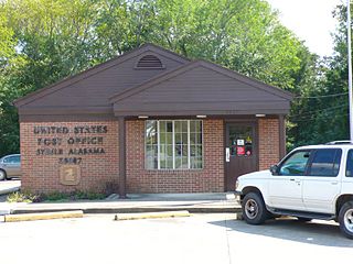
Steele is a town in northeastern St. Clair County, Alabama, United States. It was incorporated in 1952. At the 2010 census the population was 1,043, down from 1,093. The town is a part of the Birmingham–Hoover–Cullman Combined Statistical Area. It was initially known as Steel's Station or Steele's Depot in the late 19th century.

<span class="mw-page-title-main">Georgetown, Connecticut</span> Census-designated place in Connecticut, United States

Georgetown is a census-designated place in Fairfield County, Connecticut, United States. It is located in the area where the towns of Wilton, Redding, Weston, and Ridgefield meet.

<span class="mw-page-title-main">Georgetown, Idaho</span> City in Idaho, United States

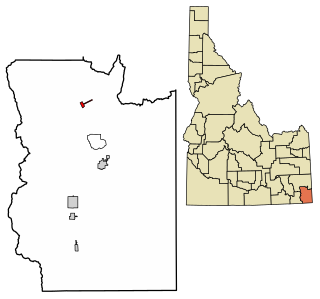
Georgetown is a city in the Bear River Valley in Bear Lake County, Idaho, United States, at the center of a farming area between the river and the mountains to the east. It was settled by Mormon pioneers on the route of the Oregon Trail and was named after George Q. Cannon. Georgetown was first settled in 1864 The population was 476 at the 2010 census. U.S. Route 30 passes through the town.

<span class="mw-page-title-main">Mount Carmel, Indiana</span> Town in Indiana, United States

Mount Carmel is a town in Springfield Township, Franklin County, Indiana, United States. The population was 86 at the 2010 census.

<span class="mw-page-title-main">Markle, Indiana</span> Town in Indiana, United States

Markle is a town in Huntington and Wells counties, in the U.S. state of Indiana. The population was 1,071 at the 2020 census. It lies along Interstate 69, U.S. Route 224, State Road 116 and State Road 3.

<span class="mw-page-title-main">Manchester, Maine</span> Town in Maine, United States

Manchester is a town in Kennebec County, Maine, United States, located at 44.33°N 69.87°W. The population was 2,456 at the 2020 census. The southern part of the town bordering Cobbosseecontee Lake is a popular recreation spot in central Maine, and part of the Winthrop Lakes Region. Manchester is included in the Augusta, Maine micropolitan and included in the Lewiston-Auburn, Maine metropolitan New England City and Town Area.

<span class="mw-page-title-main">Georgetown, Minnesota</span> City in Minnesota, United States

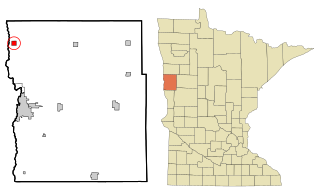
Georgetown is a city in Clay County, Minnesota, United States, along the Buffalo River near its confluence with the Red River of the North. The population was 86 at the 2020 census.
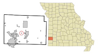
Georgetown is a town in Madison County, New York, United States. The population was 974 at the 2010 census.

<span class="mw-page-title-main">Kendrick, Oklahoma</span> Town in Oklahoma, United States

Kendrick is a town in Lincoln County, Oklahoma, United States. The population was 139 at the 2010 census.

<span class="mw-page-title-main">York Haven, Pennsylvania</span> Borough in Pennsylvania, United States

York Haven is a borough in York County, Pennsylvania, United States. The population was 691 at the 2020 census. It is part of the York–Hanover metropolitan area. The borough is the home of the Brunner Island coal-fired electrical generation plant, located on the Susquehanna River on Wago Road and operated by PPL Corporation.

<span class="mw-page-title-main">Carpendale, West Virginia</span> Town in West Virginia, United States

Carpendale is a town in Mineral County, West Virginia, United States, and part of the Cumberland, MD-WV Metropolitan Statistical Area'. The population was 861 at the 2020 census. Carpendale was incorporated on January 2, 1990, by the Circuit Court. The town is a combination of three subdivisions of which its name reflects: Carpenters Addition, Millerdale I, and Millerdale II. There are no stores in Carpendale and there is only one road in and out of the town.

<span class="mw-page-title-main">Pennsboro, West Virginia</span> City in West Virginia, United States

Pennsboro is a city in Ritchie County, West Virginia, United States. The population was 1,050 at the 2020 census. The city is located at the junction of U.S. Route 50 and West Virginia Route 74; the North Bend Rail Trail also passes through the city.

<span class="mw-page-title-main">Chippewa, Wisconsin</span> Town in Wisconsin, United States

Chippewa is a town in Ashland County in the U.S. state of Wisconsin. The population was 374 at the 2010 census.

<span class="mw-page-title-main">Marion, Juneau County, Wisconsin</span> Town in Wisconsin, United States

Marion is a town in Juneau County, Wisconsin, United States. The population was 433 at the 2000 census.

<span class="mw-page-title-main">Nokomis, Wisconsin</span> Town in Wisconsin, United States

Nokomis is a town in Oneida County, Wisconsin, United States. The population was 1,371 at the 2010 census.

<span class="mw-page-title-main">Georgetown, Price County, Wisconsin</span> Town in Wisconsin, United States

Georgetown is a town in Price County, Wisconsin, United States. The population was 164 at the 2000 census.

<span class="mw-page-title-main">Greenbush, Wisconsin</span> Town in Wisconsin, United States

Greenbush is a town in Sheboygan County, Wisconsin, United States. The population was 2,773 at the 2000 census. It is included in the Sheboygan, Wisconsin Metropolitan Statistical Area. The census-designated place of Greenbush is located in the town. The unincorporated community of German Corners is also located in the town.

Lowell is a town in Dodge County, Wisconsin, United States. The population was 1,169 at the 2000 census. The Village of Lowell and the unincorporated community of North Lowell are located in the town.

<span class="mw-page-title-main">Boscobel (town), Wisconsin</span> Town in Wisconsin, United States

Boscobel is a town in Grant County, Wisconsin, United States. The population was 433 at the 2000 census. The town borders the city of Boscobel.

<span class="mw-page-title-main">Hammond, Wisconsin</span> Village in Wisconsin, United States

Hammond is a village in St. Croix County, Wisconsin, United States. The population was 1,922 at the 2010 census. The village is located within the Town of Hammond. Hammond was home to the Running of the Llamas.

References

  1. 1 2 "US Board on Geographic Names". United States Geological Survey. October 25, 2007. Retrieved January 31, 2008.
  2. 1 2 "U.S. Census website". United States Census Bureau . Retrieved January 31, 2008.