Ghola, Kolkata

Last updated
Ghola
Neighbourhoods in Kolkata
India West Bengal adm location map.svg
Red pog.svg
Ghola
Location in West Bengal, India
India location map.svg
Red pog.svg
Ghola
Ghola (India)
Coordinates: 22°41′47″N88°24′32″E / 22.6964960°N 88.4089351°E / 22.6964960; 88.4089351 Coordinates: 22°41′47″N88°24′32″E / 22.6964960°N 88.4089351°E / 22.6964960; 88.4089351
CountryFlag of India.svg  India
State West Bengal
City Kolkata
Languages
  Official Bengali, English
Time zone IST (UTC+5:30)
PIN 700111
Vehicle registration WB
Lok Sabha constituency Dum Dum
Vidhan Sabha constituency Panihati
Website wb.gov.in

Ghola is administratively in Panihati municipal city in Barrackpore subdivision of North 24 Parganas district in the Indian state of West Bengal. It is a part of Kolkata Urban Agglomeration.

Panihati Neighbourhood in Kolkata in North 24 Parganas, West Bengal, India

Panihati is a city and a municipality of North 24 Parganas district in the Indian state of West Bengal. It is a part of the area covered by Kolkata Metropolitan Development Authority (KMDA).

Barrackpore subdivision Subdivision in West Bengal, India

Barrrackpore subdivision is an administrative subdivision of the North 24 Parganas district in the Indian state of West Bengal.

North 24 Parganas district District of West Bengal in India

North 24 Parganas (abv. 24 PGS ) or sometimes North Twenty Four Parganas is a district in southern West Bengal, of eastern India. North 24 Parganas extends in the tropical zone from latitude 22º11'6" north to 23º15'2" north and from longitude 88º20' east to 89º5' east. It is bordered to Nadia by north, to Bangladesh by north and east, to South 24 Parganas and Kolkata by south and to Kolkata, Howrah and Hoogly by west. Barasat is the district headquarters of North 24 Parganas. North 24 Parganas is West Bengal's most populous district and also the most populated district in the whole of India. It is the tenth-largest district in the State by area.

Contents

Geography

Ghola%2C Kolkata
Cities and towns in the southern portion of Barrackpore subdivision in North 24 Parganas district
M: municipal city/ town, CT: census town,
N: neighbourhood/ administrative location
Owing to space constraints in the small map, the actual locations in a larger map may vary slightly

Location

Ghola is located at 22°41′47″N88°24′32″E / 22.6964960°N 88.4089351°E / 22.6964960; 88.4089351 .

96% of the population of Barrackpore subdivision (partly presented in the map alongside) lives in urban areas. In 2011, it had a density of population of 10,967 per km2 The subdivision has 16 municipalities and 24 census towns. [1]

For most of the cities/ towns information regarding density of population is available in the Infobox. Population data is not available for neighbourhoods. It is available for the entire municipal area and thereafter ward-wise.

Police station

Ghola police station under Barrackpore Police Commissionerate has jurisdiction over Panihati and New Barrackpore municipal areas. [2] [3]

Barrackpore Police Commissionerate

Barrackpore Police Commissionerate or Barrackpore City Police, established on 20 January 2012, is a city police force with primary responsibilities in law enforcement and investigation within the area which roughly constitutes the Barrackpore subdivision, and is located within the northern part of Kolkata metropolitan area. The Commissionerate is part of the West Bengal Police, and is under the administrative control of Home Ministry of West Bengal. It was formed after bifurcation of the North 24 Parganas Police District, and has 12 police stations under its jurisdiction. Sanjoy Mukherjee was appointed as the first Commissioner of the Barrackpore Police Commissionerate.

New Barrackpore Neighbourhood in Kolkata in North 24 Parganas, West Bengal, India

New Barrackpore is a city and a municipality of North 24 Parganas district in the Indian state of West Bengal. It is a part of the area covered by Kolkata Metropolitan Development Authority (KMDA).

Kolkata Urban Agglomeration

The following Municipalities, Census Towns and other locations in Barrackpore subdivision were part of Kolkata Urban Agglomeration in the 2011 census: Kanchrapara (M), Jetia (CT), Halisahar (M), Balibhara (CT), Naihati (M), Bhatpara (M), Kaugachhi (CT), Garshyamnagar (CT), Garulia (M), Ichhapur Defence Estate (CT), North Barrackpur (M), Barrackpur Cantonment (CB), Barrackpore (M), Jafarpur (CT), Ruiya (CT), Titagarh (M), Khardaha (M), Bandipur (CT), Panihati (M), Muragachha (CT) New Barrackpore (M), Chandpur (CT), Talbandha (CT), Patulia (CT), Kamarhati (M), Baranagar (M), South Dumdum (M), North Dumdum (M), Dum Dum (M), Noapara (CT), Babanpur (CT), Teghari (CT), Nanna (OG), Chakla (OG), Srotribati (OG) and Panpur (OG). [4]

Kanchrapara Neighbourhood in Kolkata in North 24 Parganas, West Bengal, India

Kanchrapara is a city and a municipality of North 24 Parganas district in the Indian state of West Bengal. It is a part of the area covered by Kolkata Metropolitan Development Authority (KMDA).

Jetia Census Town in West Bengal, India

Jetia is a census town in Barrackpore I CD Block in Barrackpore subdivision in North 24 Parganas district in the Indian state of West Bengal. It is a part of Kolkata Urban Agglomeration.

Halisahar Neighbourhood in Kolkata in North 24 Parganas, West Bengal, India

Halisahar is a city and a municipality of North 24 Parganas district in the Indian state of West Bengal. It is a part of the area covered by Kolkata Metropolitan Development Authority (KMDA).

Ghola is a part of Panihati municipality. [5] [6]

Transport

Ghola is located on Sodepur-Madhyamgram road. [7]

The nearest railway stations are Madhyamgram railway station on the Sealdah-Bangaon line and the station at Sodepur on the Sealdah-Ranaghat line. [8] [7] [9]

Madhyamgram railway station Railway Station in West Bengal, India

Madhyamgram railway station is the railway station in the town of Madhyamgram. It serves the local areas of Madhyamgram, Badu and Sajirhat in the North 24 Parganas district, West Bengal, India. Many people use it every day, especially to travel to Kolkata during the peak periods. The Sodepur Road connects B.T. Road and Jessore Road through Madhyamgram.

Sodepur Neighbourhood in Kolkata in North 24 Parganas, West Bengal, India

Sodepur or Sodpur is a locality in Panihati Municipality of North 24 Parganas district in the Indian state of West Bengal. It is a part of the area covered by Kolkata Metropolitan Development Authority (KMDA).

Related Research Articles

Durganagar, Kolkata Neighbourhood in Kolkata in North 24 Parganas, West Bengal, India

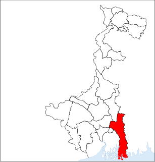
Durganagar is a locality in North Dumdum Municipality of North 24 Parganas district in the Indian state of West Bengal. It is a part of the area covered by Kolkata Metropolitan Development Authority (KMDA).

Kaugachhi Census Town in West Bengal, India

Kaugachhi is a census town in Barrackpore I CD Block in Barrackpore subdivision in North 24 Parganas district in the Indian state of West Bengal. It is a part of Kolkata Urban Agglomeration.

Muragachha Census Town in West Bengal, India

Muragachha is a census town in Barrackpore II CD Block in Barrackpore subdivision in North 24 Parganas district in the Indian state of West Bengal. It is a part of Kolkata Urban Agglomeration.

North Barrackpur Neighbourhood in Kolkata in North 24 Parganas, West Bengal, India

North Barrackpur is a city and a municipality of North 24 Parganas district in the Indian state of West Bengal. It is a part of the area covered by Kolkata Metropolitan Development Authority (KMDA).

North Dumdum Neighbourhood in Kolkata in North 24 Parganas, West Bengal, India

North Dumdum is a city and a municipality of North 24 Parganas district in the Indian state of West Bengal. It is a part of the area covered by Kolkata Metropolitan Development Authority (KMDA).

Patulia Census Town in West Bengal, India

Patulia is a census town in Barrackpore II CD Block in Barrackpore subdivision in North 24 Parganas district in the Indian state of West Bengal. It is a part of Kolkata Urban Agglomeration.

Talbandha Census Town in West Bengal, India

Talbandha is a census town in Barrackpore II CD Block in Barrackpore subdivision in North 24 Parganas district in the Indian state of West Bengal. It is a part of Kolkata Urban Agglomeration.

Chandpur, Ghola Census Town in West Bengal, India

Chandpur is a census town in Barrackpore II CD Block in Barrackpore subdivision in North 24 Parganas district in the state of West Bengal, India. It is a part of Kolkata Urban Agglomeration.

Noapara, India Census Town in West Bengal, India

Noapara is a census town in Barrackpore I CD Block in Barrackpore subdivision of North 24 Parganas district in the Indian state of West Bengal. It is a part of Kolkata Urban Agglomeration.

Noapara, West Bengal Neighbourhood in Baranagar of North 24 Parganas district, West Bengal, India

Noapara is a locality in Baranagar Municipality of North 24 Parganas district in the Indian state of West Bengal. It is a part of the area covered by Kolkata Metropolitan Development Authority (KMDA).

Balibhara Census Town in West Bengal, India

Balibhara is a census town in Barrackpore I CD Block of Barrackpore subdivision in North 24 Parganas district in the Indian state of West Bengal. It is a part of Kolkata Urban Agglomeration.

Bandipur, North 24 Parganas Census Town in West Bengal, India

Bandipur is a census town in Barrackpore II CD Block in Barrackpore subdivision of North 24 Parganas district in the state of West Bengal, India. It is a part of Kolkata Urban Agglomeration.

Teghari Census Town in West Bengal, India

Teghari is a census town in Barrackpore II CD Block in Barrackpore subdivision of North 24 Parganas district in the state of West Bengal, India. It is a part of Kolkata Urban Agglomeration.

Nimta Neighbourhood in Kolkata in North 24 Parganas, West Bengal, India

Nimta is a locality in North Dumdum Municipality of North 24 Parganas district in the Indian state of West Bengal. It is a part of the area covered by Kolkata Metropolitan Development Authority (KMDA).

Babanpur Census Town in West Bengal, India

Babanpur is a census town in Barrackpore II CD Block in Barrackpore subdivision of North 24 Parganas district in the state of West Bengal, India. It is a part of Kolkata Urban Agglomeration.

Panpur Outgrowth in West Bengal, India

Panpur is an outgrowth of Bhatpara in Barrackpore I CD Block in Barrackpore subdivision of North 24 Parganas district in the state of West Bengal, India. Panpur-Keutia is a gram panchayat. It is a part of Kolkata Urban Agglomeration.

Nanna, North 24 Parganas Outgrowth in West Bengal, India

Nanna is an outgrowth of Kanchrapara in Barrackpore I CD Block in Barrackpore subdivision of North 24 Parganas district in the state of West Bengal, India. It is a part of Kolkata Urban Agglomeration.

References

  1. "District Statistical Handbook". North 24 Parganas 2013, Tables 2.1, 2.2, 2.4b. Department of Statistics and Programme Implementation, Government of West Bengal. Retrieved 2 May 2018.
  2. "District Statistical Handbook". North 24 Parganas 2013, Table 2.1. Department of Statistics and Programme Implementation, Government of West Bengal. Retrieved 11 June 2018.
  3. "Barrackpore Police Commissionerate". List of Police Stations with telephone numbers. West Bengal Police. Retrieved 11 June 2018.
  4. "Provisional Population Totals, Census of India 2011" (PDF). Constituents of Urban Agglomeration Having Population Above 1 Lakh. Census of India 2011. Retrieved 7 June 2018.
  5. ":: Welcome to Panihati Municipality ::". Panihatimunicipality.in. Retrieved 2014-02-27.
  6. "District Census Handbook North Twenty Four Parganas, Census of India 2011, Series 20, Part XII A" (PDF). Page 379: Map of Barrackpore II CD Block, also showing Panihati and other municipal areas. Directorate of Census Operations, West Bengal. Retrieved 29 May 2018.
  7. 1 2 Google maps
  8. "31311 Sealdah-Kalyani Simanta Local". Time Table. indiarailinfo. Retrieved 15 June 2018.
  9. "33811 Sealdah-Bangaon local". Time Table. India Railinfo. Retrieved 15 June 2018.