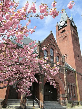
Ware is a town in Hampshire County, Massachusetts, United States. The population was 10,066 as of 2020. It is part of the Springfield, Massachusetts Metropolitan Statistical Area.

The Quabbin Reservoir is the largest inland body of water in Massachusetts, and was built between 1930 and 1939. Along with the Wachusett Reservoir, it is the primary water supply for Boston, 65 miles (105 km) to the east, and 40 other cities and towns in Greater Boston. The Quabbin also supplies water to three towns west of the reservoir and acts as backup supply for three others. By 1989, it supplied water for 2.5 million people, about 40% of the state's population at the time. It has an aggregate capacity of 412 billion US gallons (1,560 GL) and an area of 38.6 square miles (99.9 km2).

The Massachusetts Water Resources Authority (MWRA) is a public authority in the Commonwealth of Massachusetts that provides wholesale drinking water and sewage services to certain municipalities and industrial users in the state, primarily in the Boston area.

The Department of Conservation and Recreation (DCR) is a state agency of the Commonwealth of Massachusetts, situated in the Executive Office of Energy and Environmental Affairs. It is best known for its parks and parkways. The DCR's mission is "To protect, promote and enhance our common wealth of natural, cultural and recreational resources for the well-being of all." The agency is the largest landowner in Massachusetts.
The Wachusett Reservoir is the second largest body of water in the state of Massachusetts. It is located in central Massachusetts, northeast of Worcester. It is part of the water supply system for metropolitan Boston maintained by the Massachusetts Water Resources Authority (MWRA). It has an aggregate capacity of 65 billion US gallons (250,000,000 m3) and an area of almost 7 square miles (18 km2). Water from the reservoir flows to the covered Norumbega Storage Facility via the Cosgrove Tunnel and the MetroWest Water Supply Tunnel. The reservoir has a maximum depth of 120 feet (37 m) and a mean depth of 48 feet (15 m).

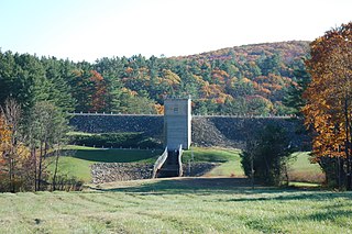
The Wachusett Dam in Clinton, Massachusetts, impounds the Nashua River, creating the Wachusett Reservoir. Construction started in 1897 and was completed in 1905. It is part of the Nashua River Watershed.

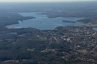
The Quabbin Valley is a region of Massachusetts in the United States. The region consists of the Quabbin Reservoir and accompanying river systems in Franklin, Hampden, Hampshire, and Worcester counties. The area is sometimes known as the Swift River Valley region, a reference to the Swift River, which was dammed to form the reservoir.
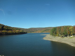
The Pepacton Reservoir, also known as the Downsville Reservoir, is a reservoir in Delaware County, New York on the East Branch of the Delaware River in the Catskill Mountains of New York. Part of the New York City water supply system, it was formed by the construction of Downsville Dam, and impounds over one-quarter of the East Branch's flow.

The Winsor Dam and the Goodnough Dike impound the waters of the Swift River and the Ware River Diversion forming the Quabbin Reservoir, the largest water body in Massachusetts. According to the Massachusetts Department of Conservation and Recreation the Winsor Dam is one of the largest dams in the Eastern U.S. The Winsor Dam is part of the Chicopee River Watershed. The Winsor Dam was named for Frank E. Winsor, its chief engineer.

The Ware River is a 35.4-mile-long (57.0 km) river in central Massachusetts. It has two forks, its West Branch, which begins in Hubbardston, Massachusetts, and its East Branch, which begins in Westminster, Massachusetts. The Ware River flows southwest through the middle of the state, joins the Quaboag River at Three Rivers, Massachusetts, to form the Chicopee River on its way to the Connecticut River.

The Wachusett Aqueduct is a secondary aqueduct that carries water from the Wachusett Reservoir to the John J. Carroll Water Treatment Plant at Walnut Hill in Marlborough, Massachusetts. It is part of the public water supply system for the communities of Greater Boston that are served by the Massachusetts Water Resources Authority (MWRA), which manages the aqueduct. The aqueduct serves as a standby backup to the Cosgrove Tunnel.
The Barre Falls Dam is located on the Ware River in Barre, Massachusetts, about 0.3 miles (0.48 km) below the junction of the river's east and west branches and 13 miles (21 km) northwest of Worcester, Massachusetts.

The Chicopee River is an 18.0-mile-long (29.0 km) tributary of the Connecticut River in the Pioneer Valley, Massachusetts, known for fast-moving water and its extraordinarily large basin: the Connecticut River's largest tributary basin. The Chicopee River originates in a Palmer, Massachusetts village called Three Rivers as a confluence of the Ware, Quaboag and Swift rivers. It passes through Wilbraham, Ludlow, and the Indian Orchard neighborhood of Springfield.
Frank E. Winsor, civil engineer, was the chief engineer for the Boston Metropolitan District Water Supply Commission, now the Massachusetts Water Resources Authority, from 1926 until his death in 1939 and was closely involved in the design and construction of Winsor Dam and Goodnough Dike which were built by the Commission to create the Quabbin Reservoir in Massachusetts. Winsor Dam was named for him.
X. Henry Goodnough (1860–1935) was an American engineer. Goodnough was chairman of Boston's Metropolitan Water District in the 1920s, and a chief advocate for the creation of the Quabbin Reservoir project. Goodnough Dike was named for him.

The Conant Brook Dam is located on Conant Brook in Monson, Massachusetts, about 7.4 miles (11.9 km) upstream from the confluence of Conant Brook and the Quaboag River. It is approximately 15 miles (24 km) east of Springfield, Massachusetts.
Lake Cochituate is a body of water in Natick, Wayland, and Framingham, Massachusetts, United States. Originally a reservoir serving Boston, it no longer serves that function, and is now a local recreational resource and home to Cochituate State Park.

Saville Dam is an earthen embankment dam with masonry work on the eastern branch of the Farmington River in southwestern Barkhamsted, Connecticut. The dam is 135 ft. tall and 1,950 ft. long and has an uncontrolled spillway on its western portion. It creates the Barkhamsted Reservoir which has a volume of 36.8 billion US gallons (139,000,000 m3) and is the primary water source for Hartford, Connecticut.

The Sudbury Reservoir is an emergency backup Boston metropolitan water reservoir in Massachusetts, located predominantly in Southborough and Marlborough, with small sections in Westborough and Framingham. It was created when the Sudbury Dam was constructed to impound the Stony Brook branch of the Sudbury River; no part of the reservoir lies in the town of Sudbury. Nearly 5,000 acres (2,000 ha) in the Sudbury Reservoir watershed are administered by the Massachusetts Department of Conservation and Recreation as a limited-access public recreation area.

