Greenville, Westchester County, New York

Last updated
Edgemont, New York
Westchester County New York incorporated and unincorporated areas Greenville highlighted.svg
Location of Edgemont, New York
Coordinates: 40°59′48″N73°49′2″W / 40.99667°N 73.81722°W / 40.99667; -73.81722
Country United States
State New York
County Westchester
Town Greenburgh
Area
  Total2.6 sq mi (6.7 km2)
  Land2.5 sq mi (6.6 km2)
  Water0.04 sq mi (0.1 km2)
Elevation
240 ft (70 m)
Population
 (2010)
  Total9,394
  Density2,793/sq mi (1,078.2/km2)
Time zone UTC-5 (Eastern (EST))
  Summer (DST) UTC-4 (EDT)
ZIP codes
10583
10530
Area code 914
FIPS code 36-30642
GNIS feature ID0951774

Greenville, commonly known as Edgemont, is a census-designated place (CDP) in the town of Greenburgh in Westchester County, New York, United States. The population was 9,394 at the 2020 census. [1] Most of its residents refer to the area as Edgemont, which is also the name of its school district. [2]

Contents

It is an ethnically diverse inner suburb of New York City, lying 22 miles (35 km) north of Columbus Circle. It is a partial bedroom community, with some of its residents working in Midtown Manhattan. Other workplaces of Greenville residents are in the offices and factories of White Plains, Yonkers, The Bronx, Rockland County, New York or Stamford, Connecticut, as well as many businesses and hospitals in southern Westchester County. The hamlet was originally ethnic Jewish and Italian but is now ethnically diverse. Its main street is Central Park Avenue. It's populated with strip malls, gas stations and outlet stores and caters mainly to shoppers from Yonkers and The Bronx.

The limits of the CDP are essentially defined by the areas served by the Edgemont Union Free School District and the Greenville Fire Department, whose areas slightly differ.

Greenville was originally a development designed by different architects for summer homes for Manhattanites. [3] With its antique colonial homes [4] and outstanding schools, it is an option for those seeking to move from New York City. Metro-North trains are accessible via the Scarsdale and Hartsdale train stations, and they run 25–55 minutes to Grand Central Terminal, depending on if one has an express or local train.

In March 2018, Bloomberg ranked Greenville as the 22nd wealthiest place in the United States, and the third wealthiest in New York. [5]

Postal address

Greenville comprises two ZIP codes: 10583 (Scarsdale, New York) and 10530 (Hartsdale, New York). Both ZIP codes encompass significant areas outside of Greenville as well. While the bulk of Greenville lies within the Scarsdale zip code, none of Greenville is part of the village of Scarsdale. According to a local real estate broker, "Edgemont is smaller and more intimate than Scarsdale". [6] Essentially, Greenville is an unincorporated CDP within Greenburgh, New York, but with a Scarsdale, New York or Hartsdale, New York mailing address depending on where in the CDP someone is.

Schools

Greenville is known for its public schools, served by the Edgemont Union Free School District. This district consists of three schools: Edgemont Junior/Senior High School, Greenville Elementary School, and Seely Place Elementary School. Each elementary school has students from kindergarten through 6th grade. Edgemont Junior/Senior High School, which sits on an 80-acre (320,000 m2) campus, contains students from grades 7 through 12.

In the U.S. News & World Report 2018 ranking of public schools, Edgemont was ranked 14th in New York State and 87th nationwide. [7] In Newsweek magazine's 2007 ranking of public high schools, Edgemont was ranked first in Westchester County and 41st nationwide. [8] Similarly, in Newsweek's 2006 public high school listings, Edgemont was ranked second in Westchester County and 56th nationwide. The magazine's 2005 listings ranked Edgemont first in Westchester County and 26th in the nation. [9] Similarly, in Westchester Magazine's 2005 rankings of public schools (the most recent time the magazine ranked schools on any criteria other than income), Edgemont was ranked first among 44 public schools in the county. [10] In 1999, U.S. News & World Report named Edgemont as one of its "examples of excellence" for a suburban public school. [11]

Incorporation

In 2016, a group of residents began circulating a petition to incorporate the Greenville Fire District into the Village of Edgemont and developed a website [12] informing residents of the impacts and opportunities of such a change. In February 2017, it was filed with the Town for certification so that the residents may vote in a referendum. Town Supervisor Paul Feiner rejected the petition, but the petitioners sued the Town and the State Supreme Court overturned the Supervisor's decision and ordered the election. The Supervisor appealed the State Supreme Court's decision.

Notable people

Geography

Greenville is located at 40°59′56″N73°49′13″W / 40.99889°N 73.82028°W / 40.99889; -73.82028 (40.998977, -73.820147), [16] in the southeastern corner of the town of Greenburgh.

According to the United States Census Bureau, the CDP has a total area of 2.6 square miles (6.7 km2), of which 2.5 square miles (6.6 km2) is land and 0.039 square miles (0.1 km2), or 1.34% is water. [1]

Transportation

The main highway to Edgemont is the Sprain Brook Parkway, which is accessed at the Jackson Avenue exit at the Edgemont-Yonkers border. The parkway is the western border of Edgemont. Some residents prefer to utilize the Bronx River Parkway, located along the eastern border of Edgemont. The main north–south road through Edgemont is Central Park Avenue, often referred to as Central Avenue by residents. Central Avenue is part of New York State Route 100. This road extends from Yonkers in the south to Somers in the north, by way of White Plains. There are four major east–west roads through Edgemont, notably Jackson Avenue, Ardsley Road, Mount Joy Avenue, and Underhill/Old Army Road. Ardsley Road experiences many backups through Edgemont into the village of Scarsdale, due to it being the primary east–west road between the eastern and western reaches of Westchester County in the 12-mile (19 km) gap between Interstate 287 and the Cross County Parkway.

Many residents commute to New York City on the Metro-North Railroad. Most park at Hartsdale station, due to Scarsdale station having scarce parking. However, some residents can walk or take the Bee-Line Bus #65 to Scarsdale station. Central Avenue also has an express bus running to 5th Avenue in Manhattan, but this takes considerably longer than the Metro-North due to traffic on the Major Deegan Expressway. Bee Line Bus route 20/21 runs from the NYC subway in the Bronx north to White Plains, and route 66 runs across Ardsley Road from the village of Dobbs Ferry to the city of New Rochelle.

Demographics

As of the census [17] of 2000, there were 8,648 people, 3,368 households, and 2,377 families residing in the CDP. The population density was 2,964.1 inhabitants per square mile (1,144.4/km2). There were 3,490 housing units at an average density of 1,196.2 per square mile (461.9/km2). The racial makeup of the CDP was 75.71% White, 2.41% African American, 0.07% Native American, 19.75% Asian, 0.01% Pacific Islander, 0.59% from other races, and 1.47% from two or more races. Hispanic or Latino of any race were 4.22% of the population.

There were 3,368 households, out of which 34.7% had children under the age of 18 living with them, 62.3% were married couples living together, 6.4% had a female householder with no husband present, and 29.4% were non-families. 26.0% of all households were made up of individuals, and 9.0% had someone living alone who was 65 years of age or older. The average household size was 2.53 and the average family size was 3.08.

In the CDP the population was spread out, with 25.1% under the age of 18, 3.8% from 18 to 24, 28.6% from 25 to 44, 28.2% from 45 to 64, and 14.3% who were 65 years of age or older. The median age was 41 years. For every 100 females there were 89.3 males. For every 100 females aged 18 and over, there were 83.8 males.

The median income for a household in the CDP was $93,421, and the median income for a family was $133,108. Males had a median income of $89,226 versus $50,155 for females. The per capita income for the CDP was $61,785. About 1.2% of families and 2.3% of the population were below the poverty line, including 1.7% of those under age 18 and 2.1% of those aged 65 or over.

Related Research Articles

<span class="mw-page-title-main">Westchester County, New York</span> County in New York, United States

Westchester County is located in the U.S. state of New York. It is the seventh most populous county in the State of New York and the most populous north of New York City. According to the 2020 United States Census, the county had a population of 1,004,456, its highest decennial count ever and an increase of 55,344 (5.8%) from the 949,113 counted in 2010. Located in the Hudson Valley, Westchester covers an area of 450 square miles (1,200 km2), consisting of six cities, 19 towns, and 23 villages. Established in 1683, Westchester was named after the city of Chester, England. The county seat is the city of White Plains, while the most populous municipality in the county is the city of Yonkers, with 211,569 residents per the 2020 U.S. Census.

<span class="mw-page-title-main">Yonkers, New York</span> City in New York, United States

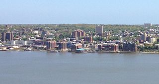
Yonkers is a city in Westchester County, New York, United States and a suburb of New York City. Developed along the Hudson River, it is the 9th–most populous incorporated place in New York State. The population of Yonkers was 211,569 as enumerated at the 2020 United States Census, its highest decennial count ever. It is classified as an inner suburb of New York City, located directly to the north of the Bronx and approximately 2.4 miles (4 km) north of Marble Hill, Manhattan, the northernmost point in Manhattan.

<span class="mw-page-title-main">Ardsley, New York</span> Village in New York, United States

Ardsley is a village in Westchester County, New York, United States. It is part of the town of Greenburgh. The village's population was 4,452 at the 2010 census. The mayor of Ardsley is Nancy Kaboolian.

<span class="mw-page-title-main">Dobbs Ferry, New York</span> Village in New York, United States

Dobbs Ferry is a village in Westchester County, New York, United States. The population was 10,875 according to the 2010 United States Census. In 2021, its population rose to an estimated 11,456. The village of Dobbs Ferry is located in, and is a part of, the town of Greenburgh. The village ZIP code is 10522. Most of the village falls within the boundaries of the Dobbs Ferry Union Free School District.

<span class="mw-page-title-main">Greenburgh, New York</span> Town in New York, United States

Greenburgh is a town in western Westchester County, New York. The population was 95,397 at the time of the 2020 census.

<span class="mw-page-title-main">Hartsdale, New York</span> Town in New York, United States

Hartsdale is a hamlet located in the town of Greenburgh, Westchester County, New York, United States. The population was 5,293 at the 2010 census. It is a suburb of New York City.

<span class="mw-page-title-main">Valhalla, New York</span> Hamlet in New York, United States

Valhalla is a hamlet and census-designated place (CDP) within the town of Mount Pleasant, in Westchester County, New York, United States, in the New York City metropolitan area. Its population was 3,162 at the 2010 U.S. Census. The name was inspired by a fan of the composer Richard Wagner, and the hamlet is known both as the home of the primary hospital campus of Westchester Medical Center and New York Medical College and as the burial place of numerous noted people. Valhalla is the realm of the gods in Norse mythology.

The Bronx River Parkway is a 19.12-mile (30.77 km) long parkway in downstate New York in the United States. It is named for the nearby Bronx River, which it parallels. The southern terminus of the parkway is at Story Avenue near the Bruckner Expressway in the Bronx neighborhood of Soundview. The northern terminus is at the Kensico Circle in Valhalla, Mount Pleasant, Westchester County, where the parkway connects to the Taconic State Parkway and, via a short connector, New York State Route 22 (NY 22). Within the Bronx, the parkway is maintained by the New York State Department of Transportation and is designated New York State Route 907H (NY 907H), an unsigned reference route. In Westchester County, the parkway is maintained by the Westchester County Department of Public Works and is designated unsigned County Route 9987 (CR 9987).

<span class="mw-page-title-main">Bronx River</span> River in New York, United States

The Bronx River, is a river that is approximately 24 miles (39 km) long, and flows through southeastern New York in the United States and drains an area of 38.4 square miles (99 km2). It is named after colonial settler Jonas Bronck. Besides the Hutchinson River, the Bronx River is the only fresh water river in New York City.

<span class="mw-page-title-main">Bee-Line Bus System</span> Bus system in Westchester County, New York, U.S.

The Westchester County Bee-Line System, branded on the buses in lowercase as the bee-line system, is a bus system serving Westchester County, New York. The system is owned by the county's Department of Public Works and Transportation.

Southern Westchester refers to the southern portion of Westchester County, New York, a dense inner-ring suburban area north of New York City.

<span class="mw-page-title-main">Saw Mill River Parkway</span>

The Saw Mill River Parkway is a north–south parkway that extends for 28.93 miles (46.56 km) through Westchester County, New York, in the United States. It begins at the border between Westchester County and the Bronx, as the continuation of the Henry Hudson Parkway leaving New York City, and heads generally northeastward to an interchange with Interstate 684 (I-684). At its north end, the parkway serves as a collector/distributor road as it passes east of the hamlet of Katonah. The parkway is named for the Saw Mill River, which the highway parallels for most of its length.

<span class="mw-page-title-main">Sprain Brook Parkway</span> North–south parkway in Westchester County, New York

The Sprain Brook Parkway is a 12.65-mile (20.36 km) long north–south parkway in Westchester County, New York, United States. It begins at an interchange with the Bronx River Parkway in the city of Yonkers, and ends at the former site of the Hawthorne Circle, where it merges into the Taconic State Parkway. The parkway serves an alternate to the Bronx River Parkway, boasting an interchange connection through western Westchester with Interstate 287. New York's Department of Transportation (NYSDOT) refers to it internally as New York State Route 987F (NY 987F), an unsigned reference route.

<span class="mw-page-title-main">New York State Route 100</span> State highway in Westchester New York, US

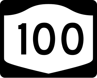
New York State Route 100 (NY 100) is a major north–south state highway in Westchester County, New York, in the United States. It begins parallel to Interstate 87 (I-87) at a junction with the Cross County Parkway in the city of Yonkers and runs through most of the length of the county up to U.S. Route 202 (US 202) in the town of Somers. NY 100 was designated as part of the 1930 renumbering of state highways in New York. Prior to becoming a state road, various sections of NY 100 were part of several important early roads in the county.

<span class="mw-page-title-main">New York State Route 100B</span> State highway in Westchester New York, US

New York State Route 100B (NY 100B) is a 2.88-mile (4.63 km) spur route of NY 100 in Westchester County, New York, in the United States. The route follows Dobbs Ferry Road across the southern part of the town of Greenburgh, connecting NY 9A to NY 119. It does not directly connect to NY 100; however, it intersects NY 100A about 1 mile (1.6 km) west of NY 119. NY 100B was assigned in the late 1930s.

<span class="mw-page-title-main">Yonkers Avenue</span> Highway in New York

Yonkers Avenue is an east–west street in the city of Yonkers in Westchester County, New York, in the United States. It is one of four major east–west through routes in the city. The western terminus of the street is at Nepperhan Avenue, which connects to U.S. Route 9 (US 9) and New York State Route 9A (NY 9A). Its eastern terminus is at Bronx River Road near the Bronx River Parkway. The entirety of Yonkers Avenue is maintained by the New York State Department of Transportation as New York State Route 983C from Nepperhan Avenue to the Saw Mill River Parkway and New York State Route 984E from the Saw Mill Parkway to Bronx River Road. Both are unsigned reference route designations.

Westchester County, New York, in the United States, contains 40 public school districts, 118 private schools and 14 colleges/universities. According to the 2018 rankings provided by the education website Niche, taking into account public comments, 28 of the top 100 school districts in New York State were located in Westchester County.

Thomas J. Abinanti is an American politician, lawyer, and former member of the New York State Assembly from Greenburgh, New York. A member of the Democratic Party, Abinanti was elected to the State Assembly in 2010 to replace Assemblyman Richard Brodsky, and represented central Westchester County, New York.

The Edgemont School District or Edgemont Union Free School District is a school district in Westchester County, New York. Its superintendent is Kenneth Hamilton.

<span class="mw-page-title-main">National Register of Historic Places listings in southern Westchester County, New York</span>

This is a list of the National Register of Historic Places listings in southern Westchester County, New York, excluding the cities of New Rochelle and Yonkers, which have separate lists of their own.

References

  1. 1 2 "Geographic Identifiers: 2010 Demographic Profile Data (G001): Greenville CDP (Westchester County), New York". U.S. Census Bureau, American Factfinder. Archived from the original on February 12, 2020. Retrieved January 30, 2013.
  2. Lasky, Julie (28 August 2019). "Edgemont, N.Y.: Strong Schools and Aspirations of Autonomy". The New York Times.
  3. Habitats/Edgemont, N.Y.; A 'Cotswolds' Romp, The New York Times, October 16, 1994
  4. Coldwell Banker Residential
  5. "These Are the 100 Richest Places in America". Bloomberg.com. Retrieved 2023-05-26.
  6. "If You're Thinking of Living In Edgemont; Like Neighboring Scarsdale, but Different", The New York Times, November 23, 2003
  7. "US News Best High Schools"
  8. "Edgemont tops local high schools in Newsweek rankings", The Journal News, May 27, 2007
  9. "The Complete List of the 1,200 Top U.S. Schools" Archived 2006-08-31 at the Wayback Machine , Newsweek Magazine, May 2007
  10. "2005 High School Report Card" Archived 2005-10-28 at the Wayback Machine , Westchester Magazine
  11. " If You're Thinking of Living In Edgemont; Like Neighboring Scarsdale, but Different", p. 2, The New York Times , November 23, 2003
  12. Edgemont Incorporation Committee website
  13. Profile of Burson Archived 2010-12-16 at the Wayback Machine from Burson-Marsteller
  14. Profile of Markowitz Archived 2008-03-12 at the Wayback Machine on Vermont Secretary of State web site. (Note: this contains no reference to Edgemont.)
  15. "Rick Wolff « CBS New York". newyork.cbslocal.com. Archived from the original on 6 May 2018. Retrieved 13 January 2022.
  16. "US Gazetteer files: 2010, 2000, and 1990". United States Census Bureau. 2011-02-12. Retrieved 2011-04-23.
  17. "U.S. Census website". United States Census Bureau . Retrieved 2008-01-31.