Hondah, Arizona

Last updated

Hondah, Arizona
CDP
USA Arizona location map.svg
Red pog.svg
Hondah
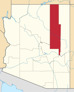
Location within the state of Arizona
Usa edcp location map.svg
Red pog.svg
Hondah
Hondah (the United States)
Coordinates: 34°05′10″N109°54′54″W / 34.08611°N 109.91500°W / 34.08611; -109.91500
CountryUnited States
State Arizona
County Navajo
Area
[1]
  Total12.20 sq mi (31.61 km2)
  Land12.17 sq mi (31.52 km2)
  Water0.04 sq mi (0.09 km2)
Elevation
[2]
7,166 ft (2,184 m)
Population
 (2020)
  Total814
  Density66.90/sq mi (25.83/km2)
Time zone UTC-7 (MST)
Area code 928
FIPS code 04-33440
GNIS feature ID2582798 [2]

Hondah is a census-designated place (CDP) in Navajo County, Arizona, United States, on the Fort Apache Indian Reservation. The population was 812 at the 2010 census.

Contents

Hondah is home to the Hon-Dah Resort Casino and Conference Center, operated by the tribe.

Geography

Hondah is located at 34°05′10″N109°54′54″W / 34.08611°N 109.91500°W / 34.08611; -109.91500 (34.085974, −109.914952). According to the United States Geological Survey, the CDP has a total area of 12.28 square miles (31.8 km2), 12.24 square miles (31.7 km2) land and 0.04 square miles (0.10 km2) water. [3]

Demographics

Historical population
CensusPop.Note
2020 814
U.S. Decennial Census [4]

As of the 2010 census, there were 812 people living in the CDP: 401 male and 411 female. 349 were 19 years old or younger, 185 were ages 20–34, 166 were between the ages of 35 and 49, 76 were between 50 and 64, and the remaining 36 were aged 65 and above. The median age was 23.5 years.

The racial makeup of the CDP was 92.7% American Indian, 3.3% White, 0.2% Black or African American, 0.2% Asian, 0.4% Other, and 3.1% two or more races. 5.0% of the population were Hispanic or Latino of any race.

There were 211 households in the CDP, 177 family households (83.9%) and 34 non-family households (16.1%), with an average household size of 3.85. Of the family households, 91 were married couples living together, with 24 single father households and 62 single mother households; the non-family households included 23 adults living alone: 13 male and 10 female.

The CDP contained 286 housing units, of which 211 were occupied and 75 were vacant. [5]

Transportation

The White Mountain Apache Tribe operates the Fort Apache Connection Transit, which provides local bus service. [6] The City of Show Low operates the Four Seasons Connection, which provides service from the Hondah Casino to Show Low and Pinetop-Lakeside. [7]

Related Research Articles

<span class="mw-page-title-main">Dennehotso, Arizona</span> CDP in Apache County, Arizona

Dennehotso is a census-designated place (CDP) in Apache County, Arizona, United States. The population was 746 at the 2010 census.

<span class="mw-page-title-main">Houck, Arizona</span> CDP in Apache County, Arizona

Houck is a census-designated place (CDP) in Apache County, Arizona, United States. The population was 1,024 at the 2010 census.

<span class="mw-page-title-main">McNary, Arizona</span> CDP in Apache and Navajo Counties, Arizona

McNary is a census-designated place (CDP) in Apache and Navajo counties in the U.S. state of Arizona, on the Fort Apache Indian Reservation. The population was 528 at the 2010 census.

<span class="mw-page-title-main">Nazlini, Arizona</span> CDP in Apache County, Arizona

Nazlini is a census-designated place (CDP) in Apache County, Arizona, United States. The population was 489 at the 2010 census. Nearby are Nazlini Creek and Nazlini Canyon. Nazlini Canyon is the site of many Native American ruins and campsites that were abandoned when erosion made them unusable.

<span class="mw-page-title-main">Red Mesa, Arizona</span> CDP in Apache County, Arizona

Red Mesa is a census-designated place (CDP) in Apache County, Arizona, United States. The population was 480 at the 2010 census.

<span class="mw-page-title-main">Rock Point, Arizona</span> CDP in Apache County, Arizona

Rock Point is a census-designated place (CDP) in Apache County, Arizona, United States. The population was 642 at the 2010 census. Its name is descriptive of the point where Chinle Creek enters high sandstone walls.

<span class="mw-page-title-main">Rough Rock, Arizona</span> CDP in Apache County, Arizona

Rough Rock is a census-designated place (CDP) in Apache County, Arizona, United States. The population was 414 at the 2010 census.

<span class="mw-page-title-main">Round Rock, Arizona</span> CDP in Apache County, Arizona

Round Rock is a Navajo community and census-designated place (CDP) in Apache County, Arizona, United States. The population was 789 at the 2010 census. It is named after a nearby mesa.

<span class="mw-page-title-main">Sawmill, Arizona</span> CDP in Apache County, Arizona

Sawmill is a census-designated place (CDP) in Apache County, Arizona, United States. Sawmill is a part of Fort Defiance Agency, which is on the Navajo Nation. The population was 748 at the 2010 census. It is named after and developed around a sawmill. A trading post has been present since 1907.

<span class="mw-page-title-main">Canyon Day, Arizona</span> CDP in Gila County, Arizona

Canyon Day is a census-designated place (CDP) in Gila County, Arizona, United States, on the Fort Apache Indian Reservation. The population was 1,209 at the 2010 census.

<span class="mw-page-title-main">Morenci, Arizona</span> CDP in Greenlee County, Arizona

Morenci is a census-designated place (CDP) and company town in Greenlee County, Arizona, United States, and was founded by the Detroit Copper Mining Company of Arizona. The population was 2,000 at the 2000 census and 1,489 at the 2010 census. The biggest employer in Morenci and the owner of the town is Freeport-McMoRan, the owner of the Morenci Mine, the largest copper mining operation in North America, and one of the largest copper mines in the world. The town was a site of the Arizona Copper Mine Strike of 1983. The large open-pit mine is north of the town.

<span class="mw-page-title-main">Desert Hills, Arizona</span> CDP in Mohave County, Arizona

Desert Hills is an unincorporated community and census-designated place (CDP) in Mohave County, Arizona, United States. The population was 2,764 at the 2020 census, up from 2,245 at the 2010 census.

<span class="mw-page-title-main">Cibecue, Arizona</span> Fort Apache Indian Reservation community

Cibecue is a census-designated place (CDP) in Navajo County, Arizona, United States, on the Fort Apache Indian Reservation. The population was 1,713 in the 2010 United States Census.

<span class="mw-page-title-main">East Fork, Arizona</span> CDP in Navajo County, Arizona

East Fork is a census-designated place (CDP) in Navajo County, Arizona, United States, on the Fort Apache Indian Reservation. The population was 699 at the 2010 census.

<span class="mw-page-title-main">Greasewood, Arizona</span> CDP in Navajo County, Arizona

Greasewood is a census-designated place (CDP) in Navajo County, Arizona, United States. The population was 547 at the 2010 census.

<span class="mw-page-title-main">Whiteriver, Arizona</span> Census designated place in Arizona, United States

Whiteriver is a census-designated place (CDP) located on the Fort Apache Indian Reservation in Navajo County, Arizona, United States. The population was 4,104 at the 2010 census, making it the largest settlement on the Reservation.

<span class="mw-page-title-main">Sells, Arizona</span> CDP in Pima County, Arizona

Sells is an unincorporated community and census-designated place (CDP) in Pima County, Arizona, United States. The population was 2,799 at the 2000 census. It is the capital of the Tohono O'odham Nation and the home of several of their tribal businesses, such as Tohono O'Odham Ki:Ki Association. Originally named Indian Oasis, by cattle-ranchers/businessmen brothers, Joseph and Louis Ménager in 1912. The Ménager brothers also built and ran the Indian Oasis Mercantile Store. The settlement took its present English name in 1918 to honor Indian Commissioner Cato Sells. The O'odham name means "Tortoise Got Wedged".

Lake of the Woods is a census-designated place (CDP) in Navajo County, Arizona, United States, adjacent to the town of Pinetop-Lakeside. The population was 4,094 at the 2010 census.

Low Mountain is a census-designated place (CDP) in Navajo County, Arizona, United States. The population was 757 at the 2010 census.

North Fork is a census-designated place (CDP) in Navajo County, Arizona, United States, on the Fort Apache Indian Reservation. The population was 1,417 at the 2010 census.

References

  1. "2020 U.S. Gazetteer Files". United States Census Bureau. Retrieved October 29, 2021.
  2. 1 2 U.S. Geological Survey Geographic Names Information System: Hondah, Arizona
  3. "Hondah CDP, Arizona – Basic Facts". AZ Hometown Locator. Retrieved November 27, 2016.
  4. "Census of Population and Housing". Census.gov. Retrieved June 4, 2016.
  5. "American FactFinder: Hondah CDP, Arizona". United States Census Bureau. Archived from the original on February 13, 2020. Retrieved November 27, 2016.
  6. "Tribal Transportation". WMAT DOT. Retrieved February 3, 2020.
  7. "White Mountain Connection". Show Low, AZ - Official Website. Retrieved January 22, 2020.