Huliyurdurga | |
|---|---|
Village | |
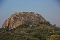
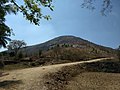
 Kumbi Betta | |
 Huliyurdurga Location in Karnataka, India  Huliyurdurga Huliyurdurga (India) | |
| Coordinates: 12°49′N77°02′E / 12.817°N 77.033°E | |
| Country | |
| State | Karnataka |
| District | Bengaluru South (Ramanagara) |
| Talukas | Kunigal |
| Population (2001) | |
• Total | 8,399 |
| Languages | |
| • Official | Kannada |
| Time zone | UTC+5:30 (IST) |
Huliyurdurga is a village in the state of Karnataka, India. [1] [2] It is located in the Kunigal taluk of Bengaluru South (Ramanagara) District of Karnataka.