
Portland is the most populous city in the U.S. state of Oregon, located in the Pacific Northwest region. Situated in the northwestern area of the state at the confluence of the Willamette and Columbia rivers, it is the county seat of Multnomah County, Oregon's most populous county. As of 2020, Portland's population was 652,503, making it the 26th-most populous city in the United States, the sixth-most populous on the West Coast, and the second-most populous in the Pacific Northwest, after Seattle. Approximately 2.5 million people live in the Portland metropolitan area, making it the 25th-most populous in the United States. About half of Oregon's population resides within the Portland metro area.

Mount Tabor is a neighborhood in Southeast Portland that takes its name from the volcanic cinder cone and city park on the volcano that it surrounds, in the U.S. state of Oregon. The name refers to Mount Tabor, Israel. It was named by Plympton Kelly, son of Oregon City pioneer resident Clinton Kelly.
Kenton is a neighborhood in the north section of Portland, Oregon, United States. The neighborhood was originally a company town founded in 1911 for the Swift Meat Packing Company.

Old Town Chinatown is the official Chinatown of the northwest section of Portland, Oregon. The Willamette River forms its eastern boundary, separating it from the Lloyd District and the Kerns and Buckman neighborhoods. It includes the Portland Skidmore/Old Town Historic District and the Portland New Chinatown/Japantown Historic District, which are listed on the National Register of Historic Places. It has been referred to as the "skid row" of Portland.
South Portland is a long, narrow neighborhood just south of Downtown Portland, Oregon, hemmed in between the Willamette River and the West Hills. It stretches from I-405 and the Marquam Bridge on the north, to SW Canby St. and the Sellwood Bridge in the south. The Willamette forms the eastern boundary, and SW Barbur Blvd. most of the western boundary. In addition to Downtown to the north, other bordering neighborhoods are Southwest Hills, Homestead, Hillsdale, and South Burlingame to the west, and Hosford-Abernethy, Brooklyn, and Sellwood-Moreland across the river on the east.
Sunnyside is a neighborhood in the south east section of Portland, between SE Stark Street and SE Hawthorne Blvd. and from SE 28th Ave. to SE 49th Ave.. The Sunnyside Neighborhood motto is "Proud Past, Bright Future". Sunnyside has a "strong sense of Portland individuality" with many locally owned coffee shops and businesses. Sunnyside is bordered by Laurelhurst to the north, Richmond to the south, Buckman to the west, and Mount Tabor to the east. Because of its Victorian architecture and bohemian culture, Hawthorne/Belmont is often compared to San Francisco's Haight Ashbury district. Sunnyside has been called Portland's "uncontested champion of eco-consciousness".

Cathedral Park is a neighborhood in Portland, Oregon. It is situated on the North Portland peninsula and lies on the east shore of the Willamette River. The neighborhood is named after Cathedral Park, which is located under the St. Johns Bridge, and was given its name due to the Gothic arches that support the bridge, which resemble a cathedral arch.
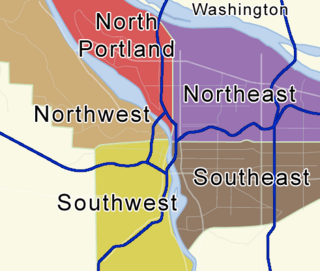
Portland, Oregon is divided into six sections: North Portland, Northeast Portland, Northwest Portland, South Portland, Southeast Portland, and Southwest Portland. There are 95 officially recognized neighborhoods, each of which is represented by a volunteer-based neighborhood association. No neighborhood associations overlap the Willamette River, but a few overlap the addressing sextants. For example, most addresses in the South Portland Neighborhood Association are South, but a portion of the neighborhood is west of SW View Point Terrace where addresses have a SW prefix. Similarly the Buckman Neighborhood Association spans both NE and SE Portland.
Hosford-Abernethy is a neighborhood in the inner Southeast section of Portland, Oregon. It borders Buckman and Sunnyside on the north, Richmond on the east, Brooklyn and Creston-Kenilworth on the south, and Downtown Portland and South Portland on the west.
Overlook is a neighborhood in the North section of Portland, Oregon on the east shore of the Willamette River. It borders University Park and Arbor Lodge on the north, Humboldt and Boise on the east, Eliot on the southeast, and Northwest Industrial and the Northwest District across the Willamette on the west.
Piedmont is a neighborhood in the north and northeast sections of Portland, Oregon, United States. The Piedmont subdivision was platted in 1889 by Edward Quackenbush, and promoted in an early flyer as "The Emerald, Portland's Evergreen Suburb, Devoted Exclusively to Dwellings, A Place of Homes." The original subdivision, now known as "Historic Piedmont," includes parts of the Humboldt and King neighborhoods, as well as the modern Piedmont neighborhood south of Rosa Parks Way.
Portsmouth is a neighborhood in the north section of Portland, Oregon, United States. It is bordered by Columbia Boulevard to the north, Lombard Street to the south, Chautauqua Boulevard to the east, and a BNSF Railway cut to the west.
Eliot is a neighborhood in the North and Northeast sections of Portland, Oregon. It is approximately bounded by the Willamette River on the west, Interstate 405 and the Kerby Avenue approach to the Fremont Bridge on the northwest, NE Fremont Street on the north, NE 7th Avenue on the east, and NE/N Broadway on the south.

Foster-Powell is a neighborhood in the Southeast section of Portland, Oregon. The triangular neighborhood is bounded by three major transit arteries: Powell Boulevard to the north, Foster Road to the south, and 82nd Avenue to the east.

North Williams Avenue is a north–south street located in Portland, Oregon, United States, and it defines the eastern boundary of North Portland. North Williams Avenue stretches from its southern terminus at Northeast Winning Way, near the Moda Center, to its northern terminus at North Winchell Street, a distance of 3.3 miles (5.3 km). It is a street common to the Portland neighborhoods Eliot, Boise, Humboldt, and Piedmont.

Albina is a collection of neighborhoods located in the North and Northeast sections of Portland, Oregon, United States. For most of the 20th century it was home to the majority of the city’s African American population. The area derives its name from Albina, Oregon, a historical American city that was consolidated into Portland in 1891. Albina includes the modern Portland neighborhoods of Eliot, Boise, Humboldt, Overlook, and Piedmont.

Lucky Labrador Brewing Company, often referred to as Lucky Lab, is a brewery based in Portland, Oregon, United States. The business was established in 1994. Gary Geist is a co-owner. The brewery became the first in Oregon to use solar power for brewing.

Victoria Bar is a bar and restaurant in Portland, Oregon.
Sweedeedee is a restaurant in Portland, Oregon.

Atlas Pizza is a pizzeria with multiple locations in Portland, Oregon, United States.
