
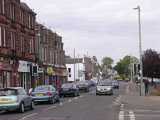
Carnoustie is a town and former police burgh in the council area of Angus, Scotland. It is at the mouth of the Barry Burn on the North Sea coast. In the 2011 census, Carnoustie had a population of 11,394, making it the fourth largest town in Angus.
Monifieth is a town and former police burgh in the council area of Angus, Scotland. It is situated on the north bank of the Firth of Tay on the east coast. In 2016, the population of Monifieth was estimated at 8,110, making it the fifth largest town in Angus.
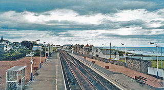
Carnoustie railway station is an unstaffed railway station which serves the town of Carnoustie, Angus, Scotland.

Newbigging is a village in Angus, Scotland, two miles north-east of Dundee. The name "Newbigging" originally referred to a "new bigging" or "new cottar town" (hamlet). The village is roughly two miles north of Monifieth and east of Dundee, Scotland's fourth city. Some of the earliest history of the local area is represented approximately four kilometres northwest at the village of Eassie, where the Eassie Stone is displayed in a ruined church; this carved Pictish stone is dated prior to the Early Middle Ages.
The Battle of Barry is a legendary battle in which the Scots, purportedly led by Malcolm II, defeated a Danish invasion force in 1010 AD. Its supposed site in Carnoustie, Angus can be seen in early Ordnance Survey maps. The history of the event relies heavily on tradition and it is currently considered to be apocryphal. The battle was named for the Parish of Barry, rather than the village, and was formerly thought to have taken place at the mouth of the Lochty burn, in the vicinity of the area that is now occupied by Carnoustie High Street. While the battle is not historically authentic, its romantic appeal continues to capture the popular imagination.

Thomas Lowson is traditionally thought to be the founder of the town of Carnoustie, Angus.

The Camus Cross, otherwise known as the Camuston or Camustane Cross, is an Early Medieval Scottish standing stone located on the Panmure Estate near Carnoustie in Angus, Scotland. First recorded in the 15th century in a legal document describing the boundaries between Camuston and the barony of Downie, and described in the 17th century by Robert Maule, it is a freestanding cross, rare in Eastern Scotland.
Redford is a hamlet in the parish of Carmyllie in Angus, Scotland. It is situated on high ground between Arbroath, on the coast, and the inland county town of Forfar. Carmyllie school is located in the settlement, as was the old Carmyllie railway station.
Muirdrum is a small village in the council area of Angus, Scotland. It is situated at the junction of the old A92 road from Dundee to Arbroath, the A930 to Carnoustie and B9128 to Forfar. Its closest town is Carnoustie, which lies approximately 2 km (1 mi) to the south.
Whigstreet is a village in the county of Angus, Scotland, between the towns of Forfar and Carnoustie. Nearby lie the remains of a temporary Roman marching camp dating to the third century AD.
Greystone is a hamlet in Angus, Scotland. It lies between the towns of Carnoustie and Forfar in the parish of Carmyllie.
Upper Victoria is a hamlet in Angus, Scotland. It lies on the A92 road between Arbroath and Dundee and is the location of the junction of the A92 and the Marches, the Craigton to Carnoustie road, forming the main route into Carnoustie.
Gardynebourg was a hamlet that once existed in Angus, Scotland, between Barry and Carnoustie. Urban growth in the latter part of the nineteenth century and early twentieth century gradually led to Gardynebourg becoming subsumed into the town of Carnoustie.
Craichie is a hamlet in the parish of Dunnichen, Angus, Scotland. Craichie is three miles south-east of Forfar and two miles south-west of Letham, at a junction on the B9128 Carnoustie to Forfar road.
Balmirmer is a hamlet in the council area of Angus, Scotland. It is situated 2 miles (3 km) north-east of Carnoustie and 4 miles (6 km) west of Arbroath. The hamlet is the location of West Balmirmer Farm, the birthplace of Margaret Fairlie, the first woman to hold a university chair in Scotland.
Salmond's Muir is a hamlet in the council area of Angus, Scotland. It is situated 2 miles (3 km) north-east of Carnoustie and 4 miles (6 km) west of Arbroath on the A92 road. The junction of the A92 at Salmond's Muir forms the main route to the villages of Panbride, East Haven, Balmirmer and Scryne.
Carlogie is a hamlet in Angus, Scotland. It lies approximately half a mile north of Carnoustie on the A930 road. Carlogie House was erected in 1854 as the residence of the factor of Panmure Estate. It was converted into a hotel in the 1960s by James Robson. Planning consent was granted to convert it into residential housing in 2007.
Woodhill is a settlement in Angus, Scotland. It lies at a central point between Carnoustie and Monifieth on the east on an unclassified road linking the A92 and A930 roads. Woodhill House was erected in 1604 by William Auchinleck, who later became Provost of Dundee. It was demolished and rebuilt in 1908.
Clayholes is a small hamlet in Angus, Scotland. It lies approximately 0.5 kilometres (0.31 mi) north of Carnoustie on the unclassified Balmachie road, that connects the A930 road in Carnoustie with the A92 road at Balmachie.

Carnoustie High School is a comprehensive secondary school in Carnoustie, Angus, Scotland. Situated to the north of the town, the school serves Carnoustie and surrounding villages, including Barry, Monikie, Newbigging, Craigton, Muirdrum, Panbride and Easthaven.
