
Hurricane Iniki was the most powerful hurricane to strike Hawaiʻi in recorded history, and the only hurricane to directly affect the state during the 1992 Pacific hurricane season. Forming on September 5, 1992, during the strong 1990–1995 El Niño, Iniki was one of eleven Central Pacific tropical cyclones during that season. It attained tropical storm status on September 8 and further intensified into a hurricane the next day. After turning north, Iniki struck the island of Kauaʻi on September 11 at peak intensity; it had winds of 145 mph and reached Category 4 status on the Saffir–Simpson hurricane scale. It had recorded wind gusts of 225 mph (362 km/h) as evidenced by an anemometer that was found blown into the forest during clean up. It was the first hurricane to hit the state since Hurricane Iwa in the 1982 season, and is the only known major hurricane to hit the state. Iniki dissipated on September 13 about halfway between Hawaii and Alaska.

Hurricane John, also known as Typhoon John, was the farthest-traveling tropical cyclone ever observed worldwide. It was also the longest-lasting tropical cyclone on record globally at the time, until it was surpassed by Cyclone Freddy in 2023. John formed during the 1994 Pacific hurricane season, which had above-average activity due to the El Niño of 1994–1995, and peaked as a Category 5 hurricane on the Saffir–Simpson scale, the highest categorization for hurricanes.

The 1999 Pacific hurricane season was one of the least active Pacific hurricane seasons on record. The season officially began on May 15 in the Eastern Pacific, and on June 1 in the Central Pacific; in both basins, it ended on November 30. These dates conventionally delimit the period during which most tropical cyclones form in the northeastern Pacific Ocean. The first tropical cyclone of the season, Hurricane Adrian, developed on June 18, while the final storm of the season, Tropical Storm Irwin, dissipated on October 11. No storms developed in the Central Pacific during the season. However, two storms from the Eastern Pacific, Dora and Eugene, entered the basin, with the former entering as a hurricane and becoming the second farthest travelling Pacific hurricane on record.

The 1986 Pacific hurricane season featured several tropical cyclones that contributed to significant flooding to the Central United States. The hurricane season officially started May 15, 1986, in the eastern Pacific, and June 1, 1986 in the central Pacific, and lasted until November 30, 1986 in both regions. These dates conventionally delimit the period of each year when most tropical cyclones form in the northeastern Pacific Ocean. A total of 17 named storms and 9 hurricanes developed during the season; this is slightly above the averages of 15 named storms and 8 hurricanes, respectively. In addition, 26 tropical depressions formed in the eastern Pacific during 1986, which, at the time, was the second most ever recorded; only the 1982 Pacific hurricane season saw a higher total.
The 1985 Pacific hurricane season is the third-most active Pacific hurricane season on record. It officially started on May 15, 1985, in the eastern Pacific, and on June 1, 1985, in the central Pacific, and lasted until November 30, 1985. These dates conventionally delimit the period of each year when most tropical cyclones form in the northeastern Pacific Ocean. At the time, the 1985 season was the most active on record in the eastern north Pacific, with 28 tropical cyclones forming. Of those, 24 were named, 13 reached hurricane intensity, and 8 became major hurricanes by attaining Category 3 status or higher on the Saffir–Simpson scale. At that time, the 24 named storms was a record; however, this record was broken seven years later in 1992, and was therefore recognized as the second busiest season within the basin, until it was surpassed exactly thirty years later by the 2015 season.

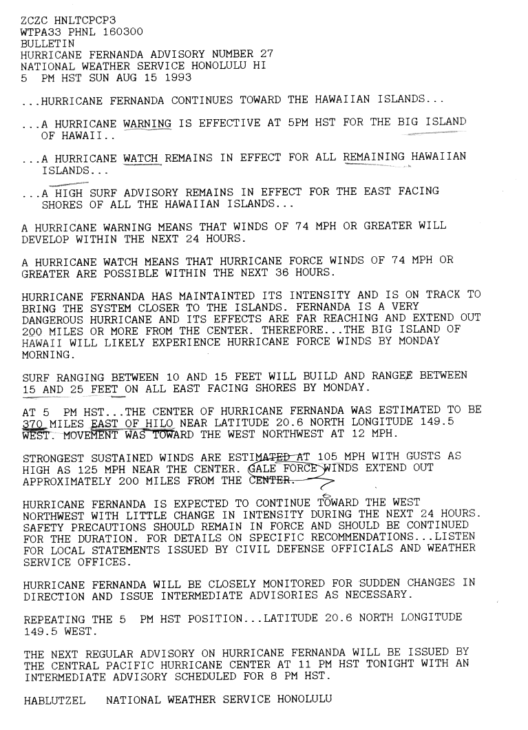
Hurricane Fefa was the only tropical cyclone during the 1991 Pacific hurricane season to directly impact the Hawaiian Islands. The sixth tropical storm, fourth hurricane, and second major hurricane of the season, the storm developed from a tropical wave on July 29 about 975 miles (1,569 km) south-southeast of Cabo San Lucas. It moved west-northwestward, and under generally favorable conditions it strengthened to attain peak winds of 120 mph (190 km/h) on August 2. Fefa turned to the west towards Hawaii, and slowly weakened until dissipating near the island of Hawaii.

Hurricane Fico was the longest-lived hurricane of the 1978 Pacific hurricane season and became the longest-lasting Pacific hurricane on record, a record broken by Hurricane Tina fourteen years later. The sixth tropical storm, fourth hurricane, and third major hurricane, Fico developed from a tropical disturbance off the Pacific coast of Mexico on July 9. It moved northwestward and then westward, quickly reaching peak winds of 140 mph (230 km/h) on July 12. Moving nearly due westward, the intensity of Fico fluctuated from Category 1 to Category 4 status on the Saffir–Simpson hurricane scale for the following days, and it passed about 170 miles (270 km) south of Hawaii on July 20 with winds of 115 mph (185 km/h). Fico slowly weakened as it turned to the northwest over cooler waters, and became an extratropical cyclone on July 28 to the northeast of Midway Island.

Hurricane Jimena was a strong tropical cyclone that brushed Hawaii in early September 2003. It was the tenth named storm and second hurricane of the 2003 Pacific hurricane season. Jimena formed on August 28 in the far Eastern Pacific Ocean as a tropical depression and moved westward where it rapidly became a hurricane the following day. The storm moved westward into the Central Pacific Ocean where it became a Category 2 hurricane on the Saffir–Simpson Hurricane Scale. After reaching its peak strength as a Category 2 hurricane, the storm began to weaken due to increasing wind shear. Jimena brushed past the Hawaiian Islands before becoming a tropical depression on September 3. The weakening storm then crossed the international dateline before dissipating on September 5, becoming one of the few storms to cross both 140ºW and International Date Line.

Hurricane Dora was one of few tropical cyclones to track across all three north Pacific basins and the first since Hurricane John in 1994. The fourth named storm, third hurricane, and second major hurricane of the 1999 Pacific hurricane season, Dora developed on August 6 from a tropical wave to the south of Mexico. Forming as a tropical depression, the system gradually strengthened and was upgraded to Tropical Storm Dora later that day. Thereafter Dora began heading in a steadily westward direction, before becoming a hurricane on August 8. Amid warm sea surface temperatures and low wind shear, the storm continued to intensify, eventually peaking as a 140 mph (220 km/h) Category 4 hurricane on August 12.
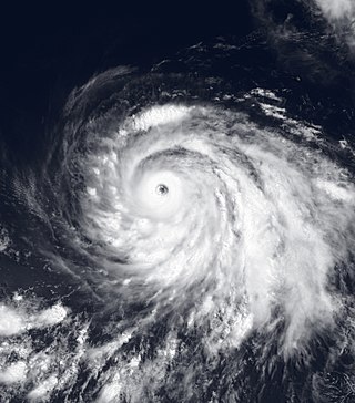
Hurricane Guillermo was the ninth-most intense Pacific hurricane on record, attaining peak winds of 160 mph (260 km/h) and a barometric pressure of 919 hPa (27.14 inHg). Forming out of a tropical wave on July 30, 1997, roughly 345 mi (555 km) south of Salina Cruz, Mexico, Guillermo tracked in a steady west-northwestward direction while intensifying. The system reached hurricane status by August 1 before undergoing rapid intensification the following day. At the end of this phase, the storm attained its peak intensity as a powerful Category 5 hurricane. The storm began to weaken during the afternoon of August 5 and was downgraded to a tropical storm on August 8. Once entering the Central Pacific Hurricane Center's area of responsibility, Guillermo briefly weakened to a tropical depression before re-attaining tropical storm status. On August 15, the storm reached an unusually high latitude of 41.8°N before transitioning into an extratropical cyclone. The remnants persisted for more than a week as they tracked towards the northeast and later south and east before being absorbed by a larger extratropical system off the coast of California on August 24.

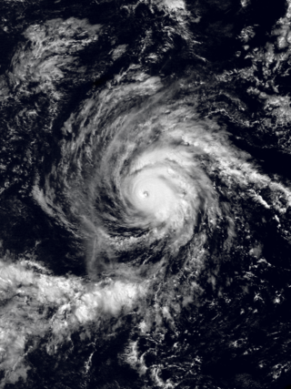
Hurricane Emilia was, at the time, the strongest tropical cyclone on record in the Central Pacific Ocean, and the second of such to be classified as a Category 5 hurricane – the highest rating on the Saffir–Simpson hurricane wind scale. However, hurricanes Gilma later that year, Ioke in 2006, and hurricanes Lane and Walaka in 2018 later reached lower barometric pressures in the Central Pacific. In addition, Emilia was the first Category 5 Pacific hurricane since Hurricane Ava in 1973. The fifth named storm and the first of three Category 5 hurricanes of the 1994 hurricane season, Emilia developed from an area of low pressure southeast of Hawaii on July 16. Tracking westward, the initial tropical depression intensified into a tropical storm several hours after tropical cyclogenesis. Subsequently, Emilia entered the Central Pacific Ocean and moved into the area of responsibility of the Central Pacific Hurricane Center (CPHC).

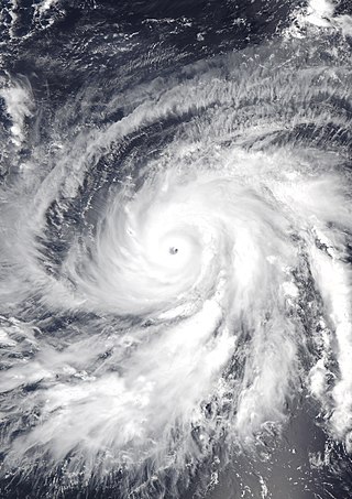
Hurricane Felicia was a powerful Category 4 Pacific hurricane whose remnants caused significant rainfall and flooding on the Hawaiian Islands. Felicia was the third strongest tropical cyclone of the 2009 Pacific hurricane season, as well as the strongest storm to exist in the eastern Pacific at the time since Hurricane Daniel in 2006. Forming as a tropical depression on August 3, the storm supported strong thunderstorm activity and quickly organized. It became a tropical storm over the following day, and subsequently underwent rapid deepening to attain hurricane status. Later that afternoon, Felicia developed a well-defined eye as its winds sharply rose to major hurricane-force on the Saffir–Simpson scale. Further strengthening ensued, and Felicia peaked in intensity as a Category 4 hurricane with sustained winds of 145 mph (233 km/h) and a barometric pressure of 935 mbar. After reaching this strength, unfavorable conditions, such as wind shear, began to impact the storm while it took on a northwestward path. Henceforth, Felicia slowly weakened for several days; by August 8 it had been downgraded to a Category 1 hurricane, once again becoming a tropical storm the next day. It retraced westward towards Hawaii on August 10, all the while decreasing in organization. On August 11, Felicia weakened to tropical depression status, and soon degenerated into remnant low just prior to passing over the islands.

Tropical Storm Omeka was the latest forming Eastern Pacific named storm since reliable records began in the 1960s. The storm was part of the 2010 Pacific typhoon and hurricane season. On December 18, 2010, the Central Pacific Hurricane Center (CPHC) began monitoring a subtropical cyclone near the International Dateline for possible tropical cyclogenesis. Over the following two days, the system tracked southwestward, entering the Western Pacific basin. It then began to transition into a tropical cyclone. Shortly before crossing the dateline on December 20, the CPHC assessed the system to have become a tropical storm. The storm was assigned the name Omeka several hours later as it moved into the CPHC's area of responsibility, which is from 140°W to the International Dateline. Upon doing so, Omeka attained its peak intensity with winds of 60 mph (100 km/h). Later on December 20, wind shear in the region increased, causing the system to weaken. By December 21, the center of Omeka was devoid of convection and dissipated on the next day. Omeka brushed Lisianski Island but caused no damage.

Hurricane Celeste was the first known tropical cyclone to strike Johnston Atoll as a hurricane. Forming from a disturbance in the East Pacific on August 6, the storm began a general westward movement it would take throughout most of its life. The storm intensified steadily, becoming a Category 1 hurricane on August 10. It kept steady at this intensity until it reached the Central Pacific. Upon entering the Central Pacific, intensification began anew, and by August 14, the hurricane reached a peak intensity of 130 mph (210 km/h). After maintaining this intensity for twelve hours, the hurricane began to weaken while passing south of Hawaii. The weakening phase was similar to its intensification in that the storm lost intensity slowly. Celeste then made a turn to the northwest and dropped below hurricane intensity on August 21. The storm then entered an area of vertical wind shear, causing it to dissipate soon after.
Hurricane Ignacio was a Pacific hurricane that threatened Hawaii during July 1985, but ultimately had little impact on the island chain. Ignacio was the eleventh tropical cyclone, ninth named storm, and third hurricane and major hurricane of the very active 1985 Pacific hurricane season. A tropical depression formed on July 21 far from land. It became Tropical Storm Ignacio later that day. Ignacio then rapidly intensified and peaked with 130 mph (215 km/h) winds on July 24. Ignacio weakened quickly, though it briefly leveled off in intensity as a Category 2 hurricane. Ignacio was downgraded into a tropical storm on July 26 while passing south of Hawaii. Continuing to weaken, Ignacio dissipated on July 27. A hurricane watch was briefly issued for the Hawaiian Islands even though the watch was dropped when Ignacio weakened. However, Ignacio still brought high waves and light rainfall to the islands. A few roads were closed, but otherwise, damage was minimal.

Hurricane Gil was the first of several tropical cyclones to affect Hawaii during the 1983 Pacific hurricane season. The seventh named storm and third hurricane of the annual season, Gil originated from a tropical depression that developed near Clipperton Island on July 23. Steadily intensifying, it attained tropical storm status six hours later and was upgraded to a hurricane on July 26. After attaining peak intensity on July 27, Gil encountered cooler sea surface temperatures and began to weaken. Moving west-northwest, the weakening system also accelerated and on July 31, was downgraded to a tropical depression. However, Gil began to re-intensify on August 1, becoming a tropical storm again later that day. Initially expected to veer north of Hawaii, it continued west-northwest and began to approach the Hawaiian group on August 3. While passing through the island group, Gil reached its secondary peak intensity. Subsequently, Gil began to weaken once again as it threatened the Northwestern Hawaiian Islands. After passing through the islands, Gil was downgraded to a tropical depression on August 5. Several hours later, the storm dissipated. The remnants of the storm moved into the West Pacific late on August 6 and were last noted the next morning while passing south of Midway Island.

Tropical Storm Flossie yielded stormy weather to Hawaii in late July 2013. The sixth tropical cyclone and named storm of the annual hurricane season, Flossie originated from a tropical wave that emerged off the western coast of Africa on July 9. Tracking westward across the Atlantic with little development, it passed over Central America and into the eastern Pacific Ocean on July 18, where favorable environmental conditions promoted steady organization. By 0600 UTC on July 25, the wave acquired enough organization to be deemed a tropical depression; it intensified into a tropical storm six hours later. Continuing westward, Flossie attained peak winds of 70 mph (110 km/h) on July 27 before entering the central Pacific Ocean. There, unfavorable upper-level winds established a weakening trend; on July 30, Flossie weakened to a tropical depression, and by 1200 UTC that same day, the storm degenerated into a remnant low, northeast of Kauai.

Hurricane Ana was the second tropical cyclone in 2014 to threaten the U.S. state of Hawaii, after Iselle in August. The twenty-first named storm and fifteenth hurricane of the 2014 Pacific hurricane season, Ana formed from a disturbance that formed in the Central Pacific in mid-October. It rapidly consolidated, and a tropical depression developed by October 13. Aided by favorable conditions, Ana gradually strengthened while moving westward, threatening to pass over the island chain of Hawaii once or several times as indicated by early forecasts. By October 17, it had strengthened to a hurricane south of Hawaii and reached its peak intensity shortly afterwards while also making its closest approach. Afterwards, Ana weakened and began to fluctuate in intensity as it turned to the north and eventually northeast as it rounded a subtropical ridge and interacted with a cold front before becoming a hurricane briefly again on October 25. Ana transitioned into an extratropical cyclone on October 26, and raced across the northwest Pacific before dissipating by October 28 after it came ashore in Western Canada.
Hurricane Walaka was a Category 5 hurricane that brought high surf and a powerful storm surge to the Hawaiian Islands. Walaka was the nineteenth named storm, twelfth hurricane, eighth major hurricane, and second Category 5 hurricane of the 2018 Pacific hurricane season.


