
The Ganges, or Ganga, is a trans-boundary river of the Indian subcontinent which flows through the nations of India and Bangladesh. The 2,525 km (1,569 mi) river rises in the western Himalayas in the Indian state of Uttarakhand, and flows south and east through the Gangetic Plain of North India. After entering West Bengal, it divides into two rivers: the Hooghly and the Padma River. The Hooghly, or Adi Ganga, flows through several districts of West Bengal and into the Bay of Bengal near Sagar Island. The other, the Padma, also flows into and through Bangladesh, and joins the Meghna river which ultimately empties into the Bay of Bengal.
Indian or Indians refers to people or things related to India, or to the indigenous people of the Americas, or Aboriginal Australians until the 19th century.

The Lewis and Clark Expedition from May 1804 to September 1806, also known as the Corps of Discovery Expedition, was the first American expedition to cross the western portion of the United States. It began in Pittsburgh, Pa, made its way westward, and passed through the Continental Divide of the Americas to reach the Pacific coast. The Corps of Discovery was a selected group of US Army volunteers under the command of Captain Meriwether Lewis and his close friend Second Lieutenant William Clark.

The Punjab, also spelled Panjab, is a geopolitical, cultural and historical region in South Asia, specifically in the northern part of the Indian subcontinent, comprising areas of eastern Pakistan and northern India. The boundaries of the region are ill-defined and focus on historical accounts.

The Himalayas, or Himalaya, form a mountain range in Asia, separating the plains of the Indian subcontinent from the Tibetan Plateau. The range has many of the Earth's highest peaks, including the highest, Mount Everest. The Himalayas include over fifty mountains exceeding 7,200 m (23,600 ft) in elevation, including ten of the fourteen 8,000-metre peaks. By contrast, the highest peak outside Asia is 6,961 m (22,838 ft) tall.

The Sioux, also known as Očhéthi Šakówiŋ, are groups of Native American tribes and First Nations peoples in North America. The term can refer to any ethnic group within the Great Sioux Nation or to any of the nation's many language dialects. The modern Sioux consist of two major divisions based on language divisions: the Dakota and Lakota.
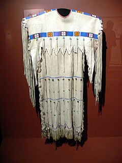
The Cheyenne are one of the indigenous people of the Great Plains and their language is of the Algonquian language family. The Cheyenne comprise two Native American tribes, the Só'taeo'o or Só'taétaneo'o and the Tsétsêhéstâhese. These tribes merged in the early 19th century. Today, the Cheyenne people are split into two federally recognized Nations: the Southern Cheyenne, who are enrolled in the Cheyenne and Arapaho Tribes in Oklahoma, and the Northern Cheyenne, who are enrolled in the Northern Cheyenne Tribe of the Northern Cheyenne Indian Reservation in Montana.

As general terms, Indian Territory, the Indian Territories, or Indian country describe an evolving land area set aside by the United States Government for the relocation of Native Americans who held aboriginal title to their land. In general, the tribes ceded land they occupied in exchange for land grants in 1803. The concept of an Indian Territory was an outcome of the 18th- and 19th-century policy of Indian removal. After the Civil War (1861–1865), the policy of the government was one of assimilation.
The Trail of Tears was a series of forced relocations of Native Americans in the United States from their ancestral homelands in the Southeastern United States, to areas to the west that had been designated as Indian Territory. The forced relocations were carried out by government authorities following the passage of the Indian Removal Act in 1830. The relocated peoples suffered from exposure, disease, and starvation while en route to their new designated reserve, and many died before reaching their destinations. The forced removals included members of the Cherokee, Muscogee (Creek), Seminole, Chickasaw, and Choctaw nations, as well as their African slaves. The phrase "Trail of Tears" originates from a description of the removal of many Native American tribes, including the infamous Cherokee Nation relocation in 1838.

Indian River County is a county located in the Treasure Coast region of the U.S. state of Florida. As of the 2010 census, the population was 138,028. Its seat is Vero Beach. It is Florida's 7th richest county and in 2000 was the 87th richest county in the U.S. by per capita income.

The Midwestern United States, also referred to as the American Midwest, Middle West, or simply the Midwest, is one of four census regions of the United States Census Bureau. It occupies the northern central part of the United States. It was officially named the North Central Region by the Census Bureau until 1984. It is located between the Northeastern United States and the Western United States, with Canada to its north and the Southern United States to its south.

The Ojibwe, Ojibwa, Chippewa, or Saulteaux are an Anishinaabe people of Canada and the United States. They are one of the most numerous indigenous peoples north of the Rio Grande. In Canada, they are the second-largest First Nations population, surpassed only by the Cree. In the United States, they have the fifth-largest population among Native American peoples, surpassed in number only by the Navajo, Cherokee, Choctaw and Sioux.

The Pottawatomi, also spelled Pottawatomie and Potawatomi, are a Native American people of the Great Plains, upper Mississippi River, and western Great Lakes region. They traditionally speak the Potawatomi language, a member of the Algonquian family. The Potawatomi called themselves Neshnabé, a cognate of the word Anishinaabe. The Potawatomi were part of a long-term alliance, called the Council of Three Fires, with the Ojibwe and Odawa (Ottawa). In the Council of Three Fires, the Potawatomi were considered the "youngest brother" and were referred to in this context as Bodéwadmi, a name that means "keepers of the fire" and refers to the council fire of three peoples.

The American Indian Wars is the collective name for the various armed conflicts fought by European governments and colonists, and later the United States and Canadian governments and American and Canadian settlers, against various American Indian and First Nation tribes. These conflicts occurred in North America from the time of the earliest colonial settlements in the 17th century until the 1920s. The various Indian Wars resulted from a wide variety of factors, including cultural clashes, land disputes, and criminal acts committed on both sides. European powers and the colonies also enlisted Indian tribes to help them conduct warfare against one another's colonial settlements.
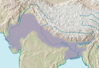
The Indo-Gangetic Plain, also known as the Indus-Ganga Plain and the North Indian River Plain, is a 630-million-acre (2.5-million km2) fertile plain encompassing Northern regions of the Indian subcontinent, including most of northern and eastern India, the eastern parts of Pakistan, virtually all of Bangladesh and southern plains of Nepal. The region is named after the Indus and the Ganges rivers and encompasses a number of large urban areas. The plain is bound on the north by the Himalayas, which feed its numerous rivers and are the source of the fertile alluvium deposited across the region by the two river systems. The southern edge of the plain is marked by the Chota Nagpur Plateau. On the west rises the Iranian Plateau.

The Eastern Ghats are a discontinuous range of mountains along India's eastern coast. The Eastern Ghats run from the northern Odisha through Andhra Pradesh to Tamil Nadu in the south passing some parts of Karnataka and in the Wayanad district of Kerala. They are eroded and cut through by four major rivers of peninsular India, viz. Godavari, Mahanadi, Krishna, and Kaveri.

The Pima are a group of Native Americans living in an area consisting of what is now central and southern Arizona. The majority population of the surviving two bands of the Akimel Oʼodham are based in two reservations: the Keli Akimel Oʼotham on the Gila River Indian Community (GRIC) and the On'k Akimel Oʼodham on the Salt River Pima-Maricopa Indian Community (SRPMIC).
The Indian River is a 121-mile (195 km) long brackish lagoon in Florida, and is part of the Indian River Lagoon system, which in turn forms part of the Atlantic Intracoastal Waterway.
Indian Head Mountain is a mountain located in the southeast corner of Greene County, New York. The mountain, named for the appearance of its profile, is part of the Devil's Path range of the Catskill Mountains. To the northwest, Indian Head is separated from Twin Mountain by Jimmy Dolan Notch; to the southeast, Indian Head is flanked by Plattekill Mountain.


