
James Barney Marsh was an American engineer and bridge designer. He patented a new design for arch bridges. Marsh gave Archie Alexander, the first African-American to graduate as an engineer from Iowa State University, his first job. Marsh worked in the bridge building business for over 50 years, and several of his bridges are listed in the National Register of Historic Places.

The William Waterfield House, also known as the Waterfield Octagon House, is a historic building located in Raymond, Iowa, United States. Built in 1867, it was added to the National Register of Historic Places on October 19, 1978. Waterfield was a New Jersey native who settled in Iowa in 1856 as a farmer, eventually operating a hotel in Raymond, possibly in this house. He was a student of phrenology and as a result he built this octagon house. Its 2-foot (0.61 m) thick walls are covered with stucco, which hides its exterior of ashlar limestone. The house is capped with an unusual hipped roof that is formed by extending its east and west roof planes.

This is a list of the National Register of Historic Places listings in Benton County, Iowa.

The Burlington, Cedar Rapids and Northern Railway (BCR&N) was a railroad that operated in the United States from 1876 to 1903. It was formed to take over the operations of the bankrupt Burlington, Cedar Rapids and Minnesota Railway, which was, in turn, the result of merging several predecessor lines, the construction of which began in 1869. The corporate headquarters were in Cedar Rapids, Iowa, and it had operations in Iowa and in Minnesota. It was succeeded by the Chicago, Rock Island and Pacific Railway.

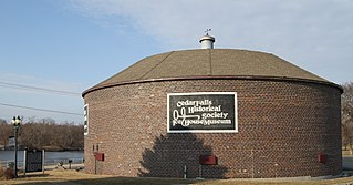
The C.A. Rownd Round Barn is a historic building located in Cedar Falls, Iowa, United States. It was built in 1911 by C.A. Rownd. It is constructed of ashlar-faced blocks that Rownd manufactured on the site. The barn was featured in the April 1912 edition of The Farm Cement News, which was published by Universal Portland Cement. The building is a true round barn that measures 83 feet (25 m) in diameter. It has been listed on the National Register of Historic Places since 1986.
The W.J. Buck Polygonal Barn was a historical structure located near Diagonal in rural Ringgold County, Iowa, United States. It was built in 1907 and was listed on the National Register of Historic Places (NRHP) in 1986. The building measured 65 feet (20 m) around. The structure of the barn was basically a central octagon with a sectioned roof. Double pitch sheds surrounded the barn characterizing it as an encircling wing type. The central section was six-sided and the wing was nine-sided. The plan appears to be the same as the one for the Lloyd Z. Jones stock barn published in Wallaces' Farmer on January 16, 1903, and again on October 25, 1907, and June 17, 1910. It has subsequently been torn down. It was removed from the NRHP in 2022.
The George Darrow Round Barn is a historic building located near Alta Vista in rural Chickasaw County, Iowa, United States. The true round barn was constructed of clay tile in 1916. The use of clay tiles suggests that it was influenced by the work of the Iowa Agricultural Experiment Station in the early 20th century. It has a diameter 64 feet (20 m), and a height of 50 feet (15 m). The barn features a two-pitch roof and a 14-foot (4.3 m) central clay tile silo. It was built as a dairy barn and it was used as such until 1978. Dairy cow stanchions surround the central silo on one side of the barn in a circular arrangement, and horse stalls surround the other side. The barn has been listed on the National Register of Historic Places (NRHP) since 1986. It has subsequently been torn down. It was removed from the NRHP in 2022.

The Frantz Round Barn is a historic building that was located near Grand Junction in rural Greene County, Iowa, United States. It was built by Beecher Lamb in 1911. The true round barn measured 55 feet (17 m) in diameter. The barn was constructed in concrete block from Mid-Iowa Concrete of Grand Junction. It featured a 56-foot (17 m) tall central silo that was 16-foot (4.9 m) in diameter. The interior had a circular around the central silo on the first floor. The second floor had stalls for 12-14 horses, a circular, haymow, and granary. The barn was listed on the National Register of Historic Places since 1986. It has subsequently been torn down.
The Clark Round Barn was an historic building located near Tyrone in rural Monroe County, Iowa, United States. It was built in 1908 for Charles Henry Clark, Sr. The building was a true round barn that measured 48 feet (15 m) in diameter. It featured a conical roof, four-sided cupola and a central silo that was 14-foot (4.3 m) in diameter and 30-foot (9.1 m) high. The siding was pine and the original cedar singles had been replaced in the 1960s. The barn was listed on the National Register of Historic Places since 1986. It was torn down in 1999.
The Cedar Falls Ice House is a historic building located in Cedar Falls, Iowa, United States. It was built in 1921 and has been listed on the National Register of Historic Places since 1977. The building currently serves as the Ice House Museum.

Mill Creek Bridge is a historic structure located in a rural area north of Clarence, Iowa, United States.The Cedar Bluff Bridge over the Cedar River was the first all-iron span built in Cedar County in 1877. Four more iron spans were built later that year, as were several others over the years before this bridge was completed in 1889. It is the only one of those bridges left, and one of the oldest pony truss bridges in the state of Iowa. Citizens in Dayton Township petitioned the Cedar County Board of Supervisors in June 1888 for the bridge over Mill Creek. The supervisors contracted with Ward and Keepers of Clinton, Iowa to design and build the bridge. The 58-foot (1,800 cm) span was built on concrete-filled iron cylinder piers, with timber stringer approach spans. Over the years sub-structural alterations have been made to the bridge. It has subsequently been abandoned and its deck is in a deteriorating condition. The bridge was listed on the National Register of Historic Places in 1998. It was relocated to Whitetails Saloon in 2020

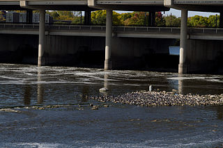
Mitchell Powerhouse and Dam is a historic structure located in Mitchell, Iowa, United States. The west side of town along the Cedar River developed into a processing and manufacturing area, and its mills were powered by the river's current. They all became obsolete and closed around the turn of the 20th-century. In 1917 the Northeastern Iowa Power Co. was incorporated at Clermont, Iowa, and in 1924 they hired the Fargo Engineering Company of Jackson, Michigan to build the powerhouse and dam at Mitchell. It was completed the following year. The concrete dam is composed of a 100-foot (30 m) permanent crest and two 32-foot (9.8 m) wide tainter gates. A third gate was converted into a permanent concrete spillway. The powerhouse is a single-story structure composed of rock faced limestone that was laid in a random ashlar pattern. Northeastern Iowa Power Company was transferred to the Central States Power and Light Company, who was in turn transferred to the Interstate Power Company. The Mitchell County Conservation Board acquired the dam, powerhouse, and the adjacent land, which it turned into a public park in 1963. The facility was listed on the National Register of Historic Places in 1978.

The Elkader Keystone Bridge is a historic structure located in Elkader, Iowa, United States. The old iron truss bridge that crossed the Turkey River at this location was declared unsafe in 1888. The Clayton County Board of Supervisors decided to construct a bridge of native limestone as way of saving money and providing a reliable crossing. Engineer M. Tschirgi designed the structure and Dubuque stonemasons Byrne and Blade constructed the bridge. It was built at a cost of $16,282, and spans the river for 346 feet (105 m). This is one of the largest twin arched keystone bridges west of the Mississippi River. A sidewalk was added on the north side of the structure in 1924. The bridge was individually listed on the National Register of Historic Places in 1976.
Turkey River Mounds State Preserve is a historic site located near the unincorporated community of Millville, Iowa, United States. The 62-acre (25 ha) preserve contains thirty-eight of forty-three Native American mounds located on a narrow Paleozoic Plateau at the confluence of the Mississippi and Turkey rivers. They vary in size and shape and are 1.3 feet (0.40 m) to 6 feet (1.8 m) in height. The conical mounds range from 20 feet (6.1 m) to over 100 feet (30 m) in diameter. The linear mounds vary from 80 feet (24 m) to 175 feet (53 m) in length. There is one effigy mound in the shape of a panther that is 98 feet (30 m) long and 40 feet (12 m) wide. There are also compound mounds in the preserve. The mounds were constructed during the Woodland period. They were used for burials and ceremonial places, and are now protected by law. The preserve is also home to a variety of trees, prairie grasses and flowers.

The A. T. Averill House is a historic building located in Cedar Rapids, Iowa, United States. Local architects Sidney Smith and William A. Fulkerson designed this 21⁄2-story, brick Late Victorian home. It was completed in 1886 for farm implement dealer Arthur Tappan Averill. This is a more restrained version of the High Victorian style. The house features a truncated hip roof, a 21⁄2-story polygonal bay, and a rectangular tower set on the diagonal. The carriage house/barn behind the house is of a similar design, but older. The house was listed on the National Register of Historic Places in 1978.

The Taylor–Van Note House, also known as Blairs Ferry Wayside Inn/Vanesther Place, is a historic building located in Cedar Rapids, Iowa, United States. Charles Taylor had this two-story, wood frame, vernacular Greek Revival house built in 1846. The family owned the house until 1888 when it was sold to Lazarus Van Note, whose family owned it as late as 1985. Oral legend has it that Taylor rented the front rooms to travelers as they passed through the region. It was located close to James Blair's ferry across the Cedar River, which is why it has long been known as the Blairs Ferry Wayside Inn. The house was built of heavy timbers and exemplifies a traditional I-house. It features two rooms on both floors across its length, and one room deep. The main door is flanked by sidelights and a transom across the top. The house was listed on the National Register of Historic Places in 1985.
The Highwater Rock is located in the Cedar River near downtown Cedar Rapids, Iowa, United States. It is a large granite boulder in the rapids in the eastern half of the river. Its height depends on the river level. It can be 3 feet (0.91 m) to 4 feet (1.2 m) above the water level in low water, or submerged in high water. It was used to gauge the river depth from the 1840s to the close of river navigation in the mid-1860s. In the early days, people could cross the river at the rapids on horseback, on foot, or by wagon and buggy. They would use the rock to determine if it was safe for them to cross. After David W. King began ferry service in 1848 and a toll bridge was built, people would use the rock to determine if the water was low enough to cross the river and avoid paying the tolls. King would use the rock to determine the amount of cargo he could carry or if he could run the ferry at all. After steam navigation was established on the river the steamer pilots would use the rock to determine if they could continue past the rapids. Railroads severely curtailed the use of steamboats on the Cedar River, and in 1870 the United States Congress declared the river was not navigable above Columbus Junction, which is well below Cedar Rapids. This put an end to water transportation on this part of the river, and the usefulness of the rock. It was listed on the National Register of Historic Places in 1977.
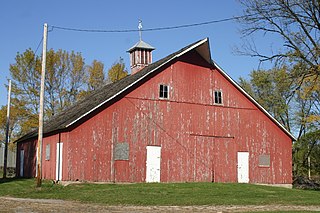
Seminole Valley Farmstead is a collection of historic farm buildings located in Seminole Valley Park on the north east side of Cedar Rapids, Iowa, United States. The historic designation includes the farmhouse, summer kitchen, livestock barn, tool shed, ice house, chicken house, and smokehouse. There is also a small orchard and a garden. The complex is located near a bend in the Cedar River. The farm represents a transitional period between Iowa's austere pioneer farms and the mechanized farms that developed later in the 20th century. The nearby timber was a source of raw materials for the farm, the fertile bottomland on which it is located provided rich soil for grazing and cultivation, and the smokehouse and ice house were used to preserve agricultural products for later consumption. At the same time the barn and the chicken house were more substantial than those from earlier times. It was listed on the National Register of Historic Places in 1976.

Oak Hill Cemetery is a rural cemetery located in Cedar Rapids, Iowa, United States. It was listed as a historic district on the National Register of Historic Places in 2013. At the time of its nomination it consisted of 17 resources, which included 13 contributing buildings, one contributing site, two contributing structures, and one contributing object.
Wickiup Hill is a Native American archeological region near Toddville, in Linn County, Iowa. The area has the Wickiup Hill Outdoor Learning Center which was built where a Meskwaki village once stood. Wickiup Hill has been excavated by archeologists.


