Jonesport, Maine

Last updated

Jonesport, Maine
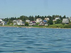
Shorefront houses, Jonesport Maine, USA.jpg
Seal of Jonesport, Maine.jpg
USA Maine location map.svg
Red pog.svg
Jonesport
Usa edcp location map.svg
Red pog.svg
Jonesport
Coordinates: 44°33′17″N67°34′41″W / 44.55472°N 67.57806°W / 44.55472; -67.57806
Country United States
State Maine
County Washington
IncorporatedFebruary 3, 1832
Communities Jonesport
Mason Bay
Monsapec
West Jonesport
Area
[1]
  Total
100.35 sq mi (259.91 km2)
  Land28.51 sq mi (73.84 km2)
  Water71.84 sq mi (186.06 km2)
Elevation
23 ft (7 m)
Population
 (2020)
  Total
1,245
  Density44/sq mi (16.9/km2)
Time zone UTC-5 (Eastern (EST))
  Summer (DST) UTC-4 (EDT)
ZIP code
04649
Area code 207
FIPS code 23-36010
GNIS feature ID0582537

Jonesport is a town in Washington County, Maine, United States. The population was 1,245 at the 2020 census. [2] Jonesport is a fishing and lobstering town. It contains the villages or hamlets of Jonesport, Mason Bay, Monsapec, and West Jonesport.

Contents

History

View of Jonesport in 1908 Looking Towards Sawyer's Cove, Jonesport, ME.jpg
View of Jonesport in 1908

Settled before the American Revolution, Jonesport was part of a grant of 48,160 acres (194.9 km2) made by the Massachusetts General Court in 1789 to John C. Jones [3] and others. It was incorporated on March 4, 1809, as Jonesborough. On February 3, 1832, a portion of Jonesborough was set off and incorporated as Jones' Port. Then a portion of Jonesport was set off and incorporated on April 7, 1925, as the island town of Beals, accessible by bridge, built in 1958, across the Moosabec Reach. [4]

Located on a peninsula 6 miles (9.7 km) out in the Gulf of Maine, the town's principal industries are fishing, boat building, harvesting blueberries, and tourist services. Jonesport includes many uninhabited islands which provide nesting areas for eider, cormorants, seagulls, razorbills, guillemots, loons, black scoters, grebes and eagles. There are two nature preserves: Western Brothers Island and the Great Wass Archipelago (which includes Great Wass Island), the latter shared with the town of Beals. [5]

In 1866, a group of Christian restorationists sailed from Jonesport to Ottoman-occupied Palestine in the hope of preparing the land for the Jews to return, thereby hastening the coming of the Christian Messiah. The Maine Friendship House, a small, wooden clapboard New England–style house built by one of those families, still stands in modern Tel Aviv. [6]

Geography

According to the United States Census Bureau, the town has a total area of 100.35 square miles (259.91 km2), of which 28.51 square miles (73.84 km2) is land and 71.84 square miles (186.06 km2) is water. [1] Jonesport is situated on a peninsula between Chandler Bay, Wohoa Bay and the tidal Indian River, all part of the Gulf of Maine and Atlantic Ocean. Roque Island, Chandler Island, Great Spruce Island, and several others are located offshore, separating Chandler Bay from Englishman Bay.

The town is crossed by Maine State Route 187. It is bordered by the towns of Addison to the west, Jonesboro to the north, and Beals to the south.

Demographics

Historical population
CensusPop.Note
1840 576
1850 82643.4%
1860 1,14839.0%
1870 1,30513.7%
1880 1,91746.9%
1890 2,12410.8%
1900 2,074−2.4%
1910 2,1292.7%
1920 1,641−22.9%
1930 1,6410.0%
1940 1,7456.3%
1950 1,727−1.0%
1960 1,563−9.5%
1970 1,326−15.2%
1980 1,51214.0%
1990 1,5250.9%
2000 1,408−7.7%
2010 1,370−2.7%
2020 1,245−9.1%
U.S. Decennial Census [7]

2010 census

As of the census [8] of 2010, there were 1,370 people, 599 households, and 384 families living in the town. The population density was 48.1 inhabitants per square mile (18.6/km2). There were 939 housing units at an average density of 32.9 per square mile (12.7/km2). The racial makeup of the town was 98.1% White, 0.1% African American, 0.7% Native American, 0.1% Asian, 0.1% from other races, and 0.9% from two or more races. Hispanic or Latino of any race were 1.3% of the population.

There were 599 households, of which 23.9% had children under the age of 18 living with them, 53.9% were married couples living together, 6.7% had a female householder with no husband present, 3.5% had a male householder with no wife present, and 35.9% were non-families. 28.4% of all households were made up of individuals, and 13.7% had someone living alone who was 65 years of age or older. The average household size was 2.23 and the average family size was 2.69.

The median age in the town was 49 years. 18.2% of residents were under the age of 18; 5.2% were between the ages of 18 and 24; 21.3% were from 25 to 44; 30.7% were from 45 to 64; and 24.4% were 65 years of age or older. The gender makeup of the town was 48.3% male and 51.7% female.

2000 census

As of the census [9] of 2000, there were 1,408 people, 597 households, and 397 families living in the town. The population density was 49.4 inhabitants per square mile (19.1/km2). There were 877 housing units at an average density of 30.8 per square mile (11.9/km2). The racial makeup of the town was 97.80% White, 0.28% African American, 0.71% Native American, 0.07% Asian, 0.14% from other races, and 0.99% from two or more races. Hispanic or Latino of any race were 0.43% of the population.

There were 597 households, out of which 27.0% had children under the age of 18 living with them, 54.3% were married couples living together, 8.4% had a female householder with no husband present, and 33.5% were non-families. 29.0% of all households were made up of individuals, and 17.4% had someone living alone who was 65 years of age or older. The average household size was 2.30 and the average family size was 2.79.

In the town, the population was spread out, with 21.0% under the age of 18, 8.8% from 18 to 24, 23.7% from 25 to 44, 23.9% from 45 to 64, and 22.7% who were 65 years of age or older. The median age was 43 years. For every 100 females, there were 91.0 males. For every 100 females age 18 and over, there were 89.3 males.

The median income for a household in the town was $23,224, and the median income for a family was $30,474. Males had a median income of $22,917 versus $15,917 for females. The per capita income for the town was $14,135. About 14.7% of families and 19.8% of the population were below the poverty line, including 22.4% of those under age 18 and 22.6% of those age 65 or over.
Sites of interest

Education

Jonesport is part of the Moosabec Community School District and School Union No. 103. The three schools in the district are Beals Elementary School, Jonesport Elementary School and Jonesport-Beals High School. [10]

Notable people

Related Research Articles

<span class="mw-page-title-main">Washington County, Maine</span> County in Maine, United States

Washington County is a county located in the U.S. state of Maine. As of the 2020 census, its population was 31,095, making it the third-least populous county in Maine. Its county seat is Machias. The county was established on June 25, 1789. It borders the Canadian province of New Brunswick. It is sometimes referred to as "Sunrise County" because it includes the easternmost point in the 48 contiguous United States. Claims have been made that Washington County is where the sun first rises on the 48 contiguous states. Many small seaside communities have small-scale fishing-based economies. Tourism is also important along the county's shoreline, but it is not as important as elsewhere in the state. The blueberry crop plays a major role in the county's economy.

<span class="mw-page-title-main">Harpswell, Maine</span> Town in the state of Maine, United States

Harpswell is a town in Cumberland County, Maine, United States, within Casco Bay in the Gulf of Maine. The population was 5,031 at the 2020 census. Harpswell is composed of land contiguous with the rest of Cumberland County, called Harpswell Neck, as well as three large islands connected by bridges: Sebascodegan Island, Orr's Island, and Bailey Island and over 200 smaller islands. Harpswell is part of the Portland–South Portland–Biddeford, Maine Metropolitan Statistical Area.

<span class="mw-page-title-main">Brooklin, Maine</span> Town in the state of Maine, United States

Brooklin is a town in Hancock County, Maine, United States. The population was 827 at the 2020 census.

<span class="mw-page-title-main">Deer Isle, Maine</span> Town in the state of Maine, United States

Deer Isle is a town in Hancock County, Maine, United States. The population was 2,194 at the 2020 census. Notable landmarks in Deer Isle are the Haystack Mountain School of Crafts, Stonington Opera House, and the town's many art galleries.

<span class="mw-page-title-main">Tremont, Maine</span> Town in the state of Maine, United States

Tremont is a town in Hancock County, Maine, United States. It is located on the southwestern side of Mount Desert Island, known to locals as "the quiet side."

<span class="mw-page-title-main">Monmouth, Maine</span> Town in the state of Maine, United States

Monmouth is a town in Kennebec County, Maine, United States. Monmouth is included in the Lewiston-Auburn, Maine metropolitan New England city and town area. The population was 4,066 at the 2020 census.

<span class="mw-page-title-main">Friendship, Maine</span> Town in the state of Maine, United States

Friendship is a town in Knox County, Maine, United States. It is 31 miles (49.9 km) southeast of Augusta. The population was 1,142 at the 2020 census.

<span class="mw-page-title-main">Alna, Maine</span> Town in the state of Maine, United States

Alna is a town in Lincoln County, Maine, United States. The population was 710 at the 2020 census. Alna is home to the Wiscasset, Waterville and Farmington Railway Museum and is noted for its historic architecture, including the early mill village of Head Tide.

<span class="mw-page-title-main">Dresden, Maine</span> Town in the state of Maine, United States

Dresden is a town in Lincoln County, Maine, United States, that was incorporated in 1794. The population was 1,725 at the 2020 census.

<span class="mw-page-title-main">Southport, Maine</span> Town in the state of Maine, United States

Southport is a town and island in Lincoln County, Maine, United States. The population was 622 at the 2020 census. It includes the neighborhoods of Capitol Island, Cozy Harbor, East Side, Newagen, Pine Cliff, and West Southport, and the village of Squirrel Island. The majority of the town's residents live on its main island, Southport Island.

<span class="mw-page-title-main">Hebron, Maine</span> Town in the state of Maine, United States

Hebron is a town in Oxford County, Maine, United States. Hebron is included in the Lewiston-Auburn, Maine metropolitan New England city and town area. The town's history has always been interconnected with Hebron Academy, a co-ed college preparatory boarding school which is located in the town's heart. The population was 1,223 at the 2020 census. There is an elementary school, Hebron Station School, located on Station Road.

<span class="mw-page-title-main">Corinna, Maine</span> Town in the state of Maine, United States

Corinna is a town in Penobscot County, Maine, United States. The population was 2,221 at the 2020 census. It is part of the Bangor metropolitan statistical area. The village of Corinna is in the southern part of the town.

<span class="mw-page-title-main">Solon, Maine</span> Town in the state of Maine, United States

Solon is a town in Somerset County, Maine, United States. The population was 978 at the 2020 census.

<span class="mw-page-title-main">Freedom, Maine</span> Town in the state of Maine, United States

Freedom is a town in Waldo County, Maine, United States. The population was 711 at the 2020 census. Freedom is a residential and recreational area.

Beals is a town in Washington County, Maine, United States, located on an island opposite Jonesport. The town was named after Manwarren Beal, an early settler. The population was 443 at the 2020 census.

Jonesboro is a town in Washington County, Maine, United States. The town was named for John Coffin Jones, a landholder. The population was 587 at the 2020 census.

<span class="mw-page-title-main">Hollis, Maine</span> Town in the state of Maine, United States

Hollis is a town in York County, Maine, United States. The population was 4,745 at the 2020 census. Hollis is a rural bedroom community of Portland and is part of the Portland–South Portland–Biddeford metropolitan statistical area.

<span class="mw-page-title-main">Lebanon, Maine</span> Town in Maine, United States

Lebanon is a town in York County, Maine, United States. The population was 6,469 at the 2020 census. Lebanon includes the villages of Center Lebanon, West Lebanon, North Lebanon, South Lebanon, and East Lebanon. It is the westernmost town in Maine. Lebanon is part of the Portland–South Portland–Biddeford, Maine metropolitan statistical area.

<span class="mw-page-title-main">Dexter, Maine</span> Town in the state of Maine, United States

Dexter is a town in Penobscot County, Maine, United States. The population was 3,803 at the 2020 census. It is part of the Bangor metropolitan statistical area. Dexter Regional High School, which serves Dexter as well as other nearby small towns, is located in the town.

<span class="mw-page-title-main">Greenville, Maine</span> Town in the state of Maine, United States

Greenville is a town in Piscataquis County, Maine, United States. The population was 1,437 at the 2020 census. The town is centered on the lower end of Moosehead Lake, the largest body of fresh water in the state. Greenville is the historic gateway to the north country and a center for outdoor recreation in the area. Greenville High School, with 89 students, was ranked as the third best high school in Maine and one of the top 1,000 in the US in 2010.

References

  1. 1 2 "US Gazetteer files 2010". United States Census Bureau. Archived from the original on July 8, 2017. Retrieved December 16, 2012.
  2. "Census - Geography Profile: Jonesport town, Washington County, Maine". United States Census Bureau . Retrieved January 20, 2022.
  3. Gannett, Henry (1905). The Origin of Certain Place Names in the United States. Govt. Print. Off. pp.  170.
  4. Coolidge, Austin J.; John B. Mansfield (1859). A History and Description of New England. Boston, Massachusetts: A.J. Coolidge. p.  962. coolidge mansfield history description new england 1859.
  5. Varney, George J. (1886), Gazetteer of the state of Maine. Jonesborough, Boston: Russell[ permanent dead link ]
  6. Joanna Paraszczuk, "An American colony in Jaffa", Nov. 27, 2009, Jerusalem Post
  7. "Census of Population and Housing". Census.gov. Retrieved June 4, 2015.
  8. "U.S. Census website". United States Census Bureau . Retrieved December 16, 2012.
  9. "U.S. Census website". United States Census Bureau . Retrieved January 31, 2008.
  10. "Moosabec Community School District and School Union No. 103". Moosabec Community School District and School Union No. 103. Retrieved June 6, 2020.

44°31′58″N67°35′54″W / 44.53278°N 67.59833°W / 44.53278; -67.59833