
Katmai National Park and Preserve is an American national park and preserve in southwest Alaska, notable for the Valley of Ten Thousand Smokes and for its brown bears. The park and preserve encompass 4,093,077 acres, which is between the sizes of Connecticut and New Jersey. Most of the national park is a designated wilderness area. The park is named after Mount Katmai, its centerpiece stratovolcano. The park is located on the Alaska Peninsula, across from Kodiak Island, with headquarters in nearby King Salmon, about 290 miles (470 km) southwest of Anchorage. The area was first designated a national monument in 1918 to protect the area around the major 1912 volcanic eruption of Novarupta, which formed the Valley of Ten Thousand Smokes, a 40-square-mile (100 km2), 100-to-700-foot-deep pyroclastic flow. The park includes as many as 18 individual volcanoes, seven of which have been active since 1900.

Aniakchak National Monument and Preserve is a U.S. National Monument and National Preserve, consisting of the region around the Aniakchak volcano on the Aleutian Range of south-western Alaska. It has erupted at least 40 times over the last 10,000 years. The 601,294-acre (243,335 ha) monument is one of the least-visited places in the National Park System due to its remote location and difficult weather. The area was proclaimed a National Monument on December 1, 1978, and established as a National Monument and Preserve on December 2, 1980. The National Monument encompasses 137,176 acres (55,513 ha) and the preserve 464,118 acres (187,822 ha). Visitation to Aniakchak is the lowest of all areas of the U.S. National Park System, according to the NPS, with only 100 documented recreational visits in 2017. Most visitors fly into Surprise Lake inside Aniakchak Crater, but the frequent fog and other adverse weather conditions make landing in the lake difficult. It is also possible to fly into the nearby village of Port Heiden and proceed overland to the Aniakchak Crater.

Lake Clark National Park and Preserve is an American national park in southwest Alaska, about 100 miles (160 km) southwest of Anchorage. The park was first proclaimed a national monument in 1978, then established as a national park and preserve in 1980 by the Alaska National Interest Lands Conservation Act. The park includes many streams and lakes vital to the Bristol Bay salmon fishery, including its namesake Lake Clark. A wide variety of recreational activities may be pursued in the park and preserve year-round. The park protects rainforests along the coastline of Cook Inlet, alpine tundra, glaciers, glacial lakes, major salmon-bearing rivers, and two volcanoes, Mount Redoubt and Mount Iliamna. Mount Redoubt is active, erupting in 1989 and 2009. The wide variety of ecosystems in the park mean that virtually all major Alaskan animals, terrestrial and marine, may be seen in and around the park. Salmon, particularly sockeye salmon, play a major role in the ecosystem and the local economy. Large populations of brown bears are attracted to feed on the spawning salmon in the Kijik River and at Silver Salmon Creek. Bear watching is a common activity in the park.
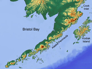
Bristol Bay is the easternmost arm of the Bering Sea, at 57° to 59° North 157° to 162° West in Southwest Alaska. Bristol Bay is 400 km (250 mi) long and 290 km, (180 mi) wide at its mouth. A number of rivers flow into the bay, including the Cinder, Egegik, Igushik, Kvichak, Meshik, Nushagak, Naknek, Togiak, and Ugashik.

The Alagnak River is a 64-mile (103 km) tributary of the Kvichak River in the U.S. state of Alaska. It has a catchment area of approximately 1400 square mi (3600 km2). It is located in central Lake and Peninsula Borough.

The Amalik Bay Archeological District is a geographic area with a significant number of archaeological sites in Alaska. It is located on the Pacific coast of Katmai National Park and Preserve, in the mainland portion of Kodiak Island Borough, Alaska.

The Brooks River Archaeological District encompasses a large complex of archaeological sites along the banks of the Brooks River in Katmai National Park and Preserve in the U.S. state of Alaska. It includes at least twenty separate settlement sites with documented occupation dates from 2500 BCE to recent (post-contact) history. It was declared a National Historic Landmark in 1993. The site is partly occupied by the Brooks Camp, one of the major visitor areas of the park.
This is a list of the National Register of Historic Places listings in Kodiak Island Borough, Alaska.

Kijik (Dena'ina: Qizhjeh) is a ghost town in Lake and Peninsula Borough, Alaska, United States. An Athabascan village that was established on the shores of Lake Clark in the Alaska Range, its population was recorded at 91 in the 1880 United States Census and declined thereafter, falling to approximately 25 individuals by 1904. Today, the village has been abandoned. The ghost town is located within the bounds of Lake Clark National Park and Preserve.
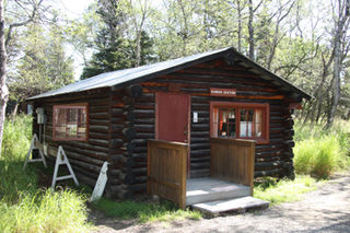
The Brooks Camp Boat House is a historic boathouse at Brooks Camp, a major visitor site in Katmai National Park and Preserve, located on the Alaska Peninsula of southwestern Alaska. The boat house is a simple rectangular log structure with large double-leaf door on the water side, and a door and window on the land side. It was built in 1959 by the National Park Service, and is the second building built in the park by the Park Service. It is used as a ranger station.

The Brooks River Historic Ranger Station is a log structure located at Brooks Camp in Katmai National Park and Preserve, located on the Alaska Peninsula of southwestern Alaska. It is a single-story building, made out of peeled logs felled in 1954 and assembled in 1955. The building was the first structure built by the National Park Service in Katmai National Park. It was built in part to oversee the growing Brooks Camp facility, which had been built over time by tourism concessionaires.
This is a list of the National Register of Historic Places listings in Katmai National Park and Preserve.

Fure's Cabin is a historic 15-by-20-foot log cabin that was built in c.1926. It is located on a narrow isthmus, on the portage trail between Naknek Lake and Lake Grosvenor in Katmai National Park and Preserve on the Alaska Peninsula. Also known as Roy Fure's Trapping Cabin, it was listed on the National Register of Historic Places in 1985; the listing included three contributing buildings and one other contributing structure.

The DIL-161 Site is a prehistoric archeological site in Katmai National Park and Preserve. Located on the banks of the Alagnak River, the site was first identified in 1997 by National Park Service personnel, and its extents were mapped in 2004. The site is that of a village that was occupied between about 300 BCE and 800 CE. More than 40 cabin sites, which are little more than house pits, have been identified.
The Kaguyak Village Site, designated 49 Afg 4, is a historic and prehistoric archaeological site on the Pacific coast of the Alaska Peninsula in Katmai National Park and Preserve. It is the site of an Alaska Native village which was abandoned after the eruption of Novarupta in 1912. The historic elements of the site include the remains of a Russian Orthodox church and cemetery, as well as a number of frame house remnants and foundations.
Takli Island is an island off the southern coast of the Alaska Peninsula in the Shelikof Strait of southwestern Alaska. It is located at the mouth of Amalik Bay, off the mainland portion of Kodiak Island Borough, in Katmai National Park and Preserve. The area was first archaeologically investigated in the 1960s, when the prehistory of the area was little known, and the island's sites are type sites for a series of archaeological cultures.

The Kukak Village Site is a prehistoric and historic archaeological site, located on the shore of Kukak Bay, on the south coast of the Alaska Peninsula in Katmai National Park and Preserve. The area was documented to be occupied in the early 20th century, and was abandoned after the 1912 volcanic eruption of Novarupta. The Kukak Bay area is also of prehistoric significance, with researchers identifying 89 depressions as likely sites of subterranean houses, and a refuse midden.

Libby's No. 23 is a historic sail-powered fishing vessel, now on display at the Lake Clark National Park and Preserve visitors center in Port Alsworth, Alaska. Built in 1914, she served in the salmon fishery of Bristol Bay until about 1951, owned by the Libby's cannery and worked by two-man crews. She is 29 feet 6 inches (8.99 m) long, with a beam of 9 feet 2 inches (2.79 m) and a depth of 4 feet (1.2 m). Its bow and stern are roughly the same shape, giving the style its name. Despite its use for freight and recreation between 1953 and 1997, the boat has retained much of its original equipment, and was fully restored by the National Park Service between 1998 and 2005, acquiring replacement parts from similar boats and removing an added motor. It is normally rigged with a mainsail and spritsail, but these are only raised when the boat is taken out of its custom-built boathouse.
The Savonoski River Archeological District encompasses a complex of prehistoric and historic archaeological sites on the Savonoski River near the mouth of the Grosvenor River in Katmai National Park and Preserve, located on the Alaska Peninsula of southwestern Alaska. At least two sites, designated 49-MK-3 and 49-MK-4 by state archaeologists, were identified when the site was listed in 1978. In 2003, the district was enlarge to include a third site, XMK-53. This area is believed to be the site of one of a group of Native Alaskan settlements referred to in Russian records as "Severnovsk". Excavations of a known prehistoric site in 1964 uncovered additional evidence of a post-contact settlement.


