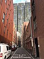
Lanes and alleyways of Sydney

Last updated
Angel Place Angel Place, Sydney.jpg
Angel Place

The lanes and alleyways of Sydney are a series of passageways found in Sydney central business district that have historically functioned by providing both off-street vehicular access to city buildings and secondary pedestrian routes through city blocks. They generally feature street art, cafes, restaurants, bars and retail outlets. [1] The Rocks has the most prominent and historical laneways in Sydney, which date to the 19th century. [2] Forgotten Songs is a popular attraction found in Angel Place. [3]

Contents

The bulk of the laneways are found at George Street and Pitt Street. Chinatown also features a number of lanes, alleys and arcades. [4] There are around 107 individual lanes in Sydney CBD, where they are demarcated by four precincts; Northern CBD, Central CBD, Western CBD and Southern CBD. [5]

History

Batson's Lane, near Sussex Street, 1900 Batson's Lane, off Sussex-street from Views taken during Cleansing Operations, Quarantine Area, Sydney, 1900, Vol. I - under the supervision of Mr George McCredie, F.I.A., N.S.W. photographed by John (5763173571).jpg
Batson's Lane, near Sussex Street, 1900
Angel Place in the 1930s. A wet Angel Place, Sydney, 1930s - Sam Hood (3293630577).jpg
Angel Place in the 1930s.

Unlike the controlled grid pattern of planned cities such as Melbourne and Adelaide, the lanes of Sydney developed as a consequence to commercial objectives and antecedent circulation patterns. Therefore, it can be assumed that all lanes have a level of importance in the city. The evolution of the lanes can be traced from 1854 to the present day. By the year 1912, the CBD had accomplished an urban shape which stayed comparatively unvarying through to about 1948. By that year, a complex and indeterminable network of small streets and lanes were evident. By 1969, the pattern of site integration and the deconstruction of lanes had begun with the establishment of Australia Square, AMP and Gold Fields House. [6]

Heritage buildings found on several lanes echo the industrial past of many of the lanes such Central Street, Albion Street and Bulletin Place. Bulletin Place and Abercrombie Lane were trendy spots for restaurants. Picture records show that Rowe Street had a long history as a retail area. The practice of Council selling lanes dates from the early 20th century. From the 1960s through to the late 1980s, over twenty-five sales of lanes or parts of lanes were transacted by Council, totaling a sum of 57 million dollars. This resulted in the loss of unique retail areas such as Rowe Street and Angel Place, and as well as loss of context for heritage buildings such as those found in Bulletin Place, Central Street and Albion Street. [6]

Revitalisation

On February 24, 1992, the council imposed a postponement on the sale of lanes due to their heritage significance. From the early 1990s, a number of lanes around Circular Quay, Martin Place and Australia Square began redevelopment. [6]

In June 2009, City of Sydney Council picked eight CBD laneways for public domain improvements, where they later included a ninth laneway. These were, Bulletin Place, Angel Place, Hosking and Penfold Place, Lees Court, Ash Street, York Lane, Albion Place, Central Street, and Wilmot Street. Between 2010 and 2016, redevelopments were completed in those lanes, with most of these precincts gaining new businesses and increased economic vibrancy. [5]

More than 10 lanes began revitalisation starting from 2021, [7] with the City of Sydney announcing a plan to modify laneways throughout the CBD by establishing new pedestrian walkways and art installations as part of the revivification proposal that will last a decade. This would include more fresco style dining and increased pedestrian access from George Street. Around 25 lanes were upgraded with the installation of bars, restaurants, retail outlets and art installations by the City of Sydney in a span of 15 years, beginning from 2007. In 2021-22, upgrading had taken place in Barlow Street, St Laurence Lane, Curtin Place, Hamilton Street, Little Hunter Street, Randle Lane, York Lane, Wynyard Lane, Underwood Street and Dalley Street. [8]

Significant lanes

Kendall Lane Kendall Lane, Sydney (483285) (9442805738).jpg
Kendall Lane

Abercrombie Lane forms a portion of formerly vital pedestrian network delimited by George, Bridge and Pitt Streets, where it connects through NZI House to Bond Street and Australia Square, and provides the possibility to recapture a pedestrian district with a specific scale and quality in the CBD. The lane has a long history as part of Sydney's pedestrian network, where it makes an appearance on William Well's 1850 map of Sydney. [6]

Wynyard Lane allows vehicle access to structures on George and Carrington Streets. Manning Lane goes through Bridge and Dalley Street, where it provides a shortcut through the building midway between George and Pitt Street. Phillip Lane allows vehicle entry to buildings on Phillip Street and Macquarie Street. Sussex Lane is parallel to Kent Street and is characterised by several terraced stores, in addition to featuring Waterside Workers' Federation Building, a heritage listed edifice. York Lane is a crucial laneway that provides access to heritage building sites and as well as access for vehicles and pedestrians. James Lane represents a number of 19th century industrial-style buildings, and it still maintains its original form. Rawson Lane near Pitt Street features heritage buildings and a view of the clock tower at the Central railway station. [6]

Ash Street was developed in 1886 where it featured luxurious 19th and early 20th century structures. Palings Lane is described by the Local Environmental Plans as a "rare example of a pedestrian route created when the north-south street grid was formed in early Victorian Sydney". Market Row features heritage-listed buildings and is defined by its significant architecture. Douglas Lane is surrounded by George, Liverpool, Sussex and Goulburn Streets and was a crucial lane for the city in the industrial age. Kimber Lane is situated in Chinatown where it is perpendicular to Dixon Street and is of cultural significance. De Maistre Place features the Watson House and has pedestrian routes from Pitt and Hunter Street to Wynyard station. [6]

Some lanes such as those within Rowe Street provide an advantageous secondary path, allowing pedestrians the choice of averting crowded and noisy city streets. Lanes such as Tankstream Way are important heritage items identified and others listed in conservation areas are conducive elements, intrinsic to the quality and character of those areas. Angel Place is part of a unique pedestrian precinct that was once enhanced by retail stores at ground floor. Dalley Street is pivotal for pedestrian and vehicular access and also for access to heritage buildings. [6]

List

Lanes, alleyways and arcades in the city include: [9] [10]

  • Bakehouse Place
  • Surgeons Court
  • Mill Lane
  • Suez Canal
  • Deans Place
  • Temperance Lane
  • Carahers Lane
  • St Laurence Lane
  • Maori Lane
  • McElhone Place
  • Atchison Lane
  • Longs Lane
  • Greenway Lane
  • Nurses Walk
  • Cribbs Lane
  • Kendall Lane
  • Angel Place
  • Ash Street
  • Crown Lane
  • Cammeraygal Place
  • May Lane
  • Caroline Lane
  • Kimber Lane
  • Palings Lane
  • Tank Stream Way
  • Penfold Lane
  • Randle Lane
  • York Lane
  • Mary’s Place
  • Llankelly Place
  • Skittle Lane
  • Strand Arcade
  • Wynyard Lane
  • Underwood Street
  • Argyle Lane
  • Dalgety Terrace
  • Ferry Lane
  • High Lane
  • Lance Lane
  • Roden's Lane
  • Windmill Steps
  • Abercrombie Lane
  • Blue Anchor Lane
  • Bridge Lane
  • Bulletin Place
  • Crane Place
  • Curtin Place
  • Customs House Lane
  • Dalley Street
  • DeMestre Place
  • Empire Lane
  • Hamilton Street
  • Little Hunter Street
  • Loftus Lane
  • Margaret Lane
  • Reiby Place
  • Underwood Lane
  • Mooreore Stairs
  • Clarence Lane
  • Gas Lane
  • Sussex Lane
  • James Lane
  • Newton Lane
  • Mark Lane
  • Barrack Lane
  • Manning Lane
  • Rawson Lane
  • Hosking Place
  • State Theatre Laneway
  • Hargrave Lane
  • Market Row
  • Douglas Lane
  • Foy Lane
  • Nithsdale Lane
  • Wright Lane
  • Bijou Lane
  • Dungate Lane
  • Foster Lane
  • Goulburn Lane
  • Hands Lane
  • Parker Lane
  • Beattie Lane
  • Beauchamp Lane

Suburbia

A fenced alleyway in Smithfield, Western Sydney Ginnel (alleway type).jpg
A fenced alleyway in Smithfield, Western Sydney

The suburban areas generally feature fenced or walled lanes that are "cut-through" residential lots, whereby granting pedestrians easy access to nearby facilities including shops, public transport, parks and other areas of interest situated on other roads. [11] [12] These passageways are more often present at the end of cul-de-sacs, where they would lead to a main road. They may feature a nature strip, though others may be completely paved. [13] They are usually secured by bollards to prevent vehicle access, although cycling is permitted. [14] They bear a resemblance to ginnels found in Northern England as they are a gap between houses. [15]

In commercial areas of suburban Sydney, several back lanes exist to simultaneously offer carparking for proximate businesses and as well as pedestrian routes as a means of shortcut. [16]

See also

Related Research Articles

<span class="mw-page-title-main">Alley</span> Narrow street that usually runs between, behind, or within buildings

See also: Alleyway

<span class="mw-page-title-main">Pitt Street Mall</span> Thoroughfare in New South Wales, Australia

Pitt Street Mall is the pedestrianised section of Pitt Street in the Sydney central business district, in the Australian state of New South Wales. Running for approximately 200 metres between Market Street and King Street, it is one block long and one of Australia's busiest and most cosmopolitan shopping precincts. Floorspace rents are the highest in Australia, in part due to other cities' shopping precincts being longer. In 2015, its rents were the fifth-highest in the world in terms of city streets.

<span class="mw-page-title-main">Wynyard railway station, Sydney</span> Heritage-listed railway station in Sydney, New South Wales, Australia

Wynyard railway station is a heritage-listed underground commuter rail station located in the north-west precinct of the Sydney central business district, in New South Wales, Australia. The station opened on 28 February 1932 to coincide with the opening of the Sydney Harbour Bridge.

<span class="mw-page-title-main">Pitt Street</span> Street in Sydney, Australia

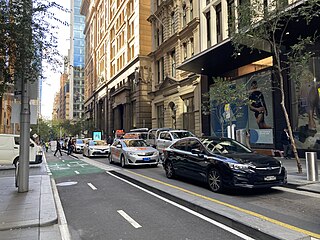
Pitt Street is a major street in the Sydney central business district in New South Wales, Australia. The street runs through the entire city centre from Circular Quay in the north to Waterloo, although today's street is in two disjointed sections after a substantial stretch of it was removed to make way for Sydney's Central railway station. Pitt Street is well known for the pedestrian only retail centre of Pitt Street Mall, a section of the street which runs from King Street to Market Street.

<span class="mw-page-title-main">George Street, Sydney</span> Street in Sydney, Australia

George Street is a street in the central business district of Sydney.

<span class="mw-page-title-main">Rundle Mall</span> Pedestrianised shopping precinct in Adelaide, South Australia

Rundle Mall is a pedestrian street mall located in Adelaide, South Australia. It was opened as a pedestrian mall in September 1976 by closing the section of Rundle Street between King William Street and Pulteney Street, to vehicular traffic. The street continues as Rundle Street to the east and Hindley Street to the west.

<span class="mw-page-title-main">Sydney central business district</span> Suburb of Sydney, New South Wales, Australia

The Sydney central business district (CBD) is the historical and main commercial centre of Sydney. The CBD is Sydney's city centre, or Sydney City, and the two terms are used interchangeably. Colloquially, the CBD or city centre is often referred to simply as "Town" or "the City". The Sydney city centre extends southwards for about 3 km (2 mi) from Sydney Cove, the point of first European settlement in which the Sydney region was initially established.

<span class="mw-page-title-main">Martin Place</span> Pedestrian mall in Sydney, New South Wales

Martin Place is a pedestrian mall in the Sydney central business district, New South Wales, Australia. Martin Place has been described as the "civic heart" of Sydney. As home to the Reserve Bank of Australia, the Commonwealth Bank, Macquarie Bank, Westpac and other corporations, it is also a centre of business and finance. The Sydney GPO is also located on Martin Place.

<span class="mw-page-title-main">Martin Place railway station</span> Railway station in Sydney, New South Wales, Australia

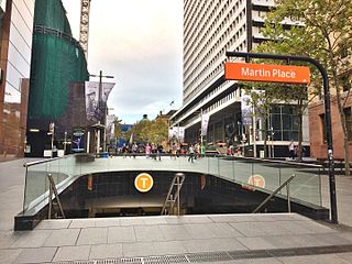
Martin Place railway station is a heritage-listed underground commuter rail station located on the Eastern Suburbs line, serving the Sydney central business district in New South Wales, Australia. Named after Martin Place, it is served by Sydney Trains T4 Eastern Suburbs & Illawarra Line services and NSW TrainLink South Coast Line services. It was designed by Fowell, Mansfield Jarvis and McLurcan and built from 1973 to 1979. It was added to the New South Wales State Heritage Register on 2 April 1999.

<span class="mw-page-title-main">Queen Street Mall</span> Thoroughfare in Brisbane, Australia

The Queen Street Mall is a pedestrian mall located on Queen Street in the centre of Brisbane, Queensland, Australia. The mall extends approximately 500 metres (1,600 ft) from George Street to Edward Street, and has more than 700 retailers over 40,000 square metres (430,000 sq ft) of retail space, which includes six major shopping centres. It was intended to bring more people into the central business district.

<span class="mw-page-title-main">Centre Place, Melbourne</span> Street in Melbourne, Australia

Centre Place is a laneway and pedestrian precinct in Melbourne, Australia. It runs north from Flinders Lane to Collins Street, between Elizabeth Street and Swanston Street.

<span class="mw-page-title-main">The Strand Arcade</span> Shopping mall in Sydney, Australia

The Strand Arcade is a heritage-listed Victorian-style retail arcade located at 195–197 Pitt Street in the heart of the Sydney central business district, between Pitt Street Mall and George Street in the City of Sydney local government area of New South Wales, Australia. It was designed by John B. Spencer, assisted by Charles E. Fairfax; and built from 1890 to 1892 by Bignell and Clark (1891), with renovations completed by Stephenson & Turner (1976). The only remaining arcade of its kind in Sydney, the property was added to the New South Wales State Heritage Register on 13 December 2011.

<span class="mw-page-title-main">General Post Office, Sydney</span> Historic building in Sydney, Australia

The General Post Office is a heritage-listed landmark building located in Martin Place, Sydney, New South Wales, Australia. The original building was constructed in two stages beginning in 1866 and was designed under the guidance of Colonial Architect James Barnet. Composed primarily of local Sydney sandstone, mined in Pyrmont, the primary load-bearing northern façade has been described as "the finest example of the Victorian Italian Renaissance Style in NSW" and stretches 114 metres (374 ft) along Martin Place, making it one of the largest sandstone buildings in Sydney.

<span class="mw-page-title-main">Julian Ashton Art School (building)</span> Historic site in New South Wales, Australia

The Julian Ashton Art School is a heritage-listed former offices and now art school and retail store at 117-119 George Street in the inner city Sydney suburb of The Rocks in the City of Sydney local government area of New South Wales, Australia. It was designed by E. Lindsay Thompson and Spooner & Dixon. It is also known as Gallery and Shop. The property is owned by Property NSW, an agency of the Government of New South Wales. It is currently tenanted by the Julian Ashton Art School. It was added to the New South Wales State Heritage Register on 10 May 2002.

<span class="mw-page-title-main">MidCity</span> Shopping mall in New South Wales, Australia

MidCity is a shopping centre in the Sydney central business district. It is located on Pitt Street Mall, adjacent to Westfield Sydney, The Strand Arcade and is diagonally opposite Glasshouse. MidCity has over 24 stores across Fashion, Beauty, Fitness and Lifestyle.

<span class="mw-page-title-main">Lanes and arcades of Melbourne</span>

The Melbourne central business district in Australia is home to numerous lanes and arcades. Often called "laneways", these narrow streets and pedestrian paths date mostly from the Victorian era, and are a popular cultural attraction for their cafes, bars and street art.

<span class="mw-page-title-main">Palings Building</span> Historic site in Queensland, Australia

The Palings Building is a heritage-listed retail building located at 86 Queen Street, Brisbane City, City of Brisbane, Queensland, Australia. It was designed by Richard Gailey as one of a row of four identical buildings and built from 1885 to 1919 by Patten & Son. Two of the four buildings have since been demolished while a third survives but is incorporated into another building. The Palings building was added to the Queensland Heritage Register on 21 October 1992; at that time, the building was used for the City International Duty Free store.

<span class="mw-page-title-main">Glasshouse (Sydney)</span> Shopping mall in New South Wales, Australia

Glasshouse is an office and retail building in the Sydney central business district. It is located on the corner of King Street and Pitt Street Mall, adjacent to Westfield Sydney and is opposite MidCity, The Strand Arcade and Sydney Arcade.

<span class="mw-page-title-main">Cumberland Place and Steps</span> Heritage-listed street in Sydney, Australia

The Cumberland Place and Steps are heritage-listed steps and a laneway located at Cumberland Place, in the inner city Sydney suburb of The Rocks in the City of Sydney local government area of New South Wales, Australia. It was built from 1807. It is also known as Suffolk Lane; Stubbs Lane; Gloucester Lane; and Cribb's Lane. The property is owned by Property NSW, an agency of the Government of New South Wales. It was added to the New South Wales State Heritage Register on 10 May 2002.

<span class="mw-page-title-main">Bulletin Place warehouses</span> Heritage-listed buildings in Sydney, Australia

The Bulletin Place Warehouses are a series of three heritage-listed former warehouses and now souvenir sales office, commercial offices, health club, storage area, and restaurant located between 6–18 Bulletin Place, in the Sydney central business district in the City of Sydney local government area of New South Wales, Australia. The warehouses were built from 1880 and have variously been known as the San Francisco Restaurant. The property is privately owned. It was added to the New South Wales State Heritage Register on 2 April 1999.

References

  1. Sydney CBD Hidden Laneways Sydney.com. Retrieved 18 November 2022.
  2. Laneway of the Rocks Pocket Guide To Sydney. Retrieved 18 November 2022.
  3. Wood, Simon. "Sydney laneway revival". ARCHITECTUREAU. Retrieved 2016-09-15.
  4. "Chinatown and Haymarket". Sydney.com. Retrieved 18 November 2022.
  5. 1 2 Decision details - Central Sydney Laneways Rebekah Celestin, City of Sydney. 29 October 2018. Retrieved 19 November 2022.
  6. 1 2 3 4 5 6 7 The City of Sydney Policy for the Management of Laneways in Central Sydney City of Sydney. 1 January 1993. Retrieved 18 November 2022.
  7. Breathing new life into the city’s laneways City of Sydney. 21 September 2021. Retrieved 18 November 2022.
  8. The City of Sydney Is Set to Revamp Ten CBD Laneways with New Walkways and Art Installations Concrete Playground. By Ben Hansen. September 22, 2021. Retrieved 18 November 2022.
  9. Lanes and streets of the Sydney CBD Pocket Guide to Sydney. Retrieved 18 November 2022.
  10. Sydney’s best laneways Timeout. 31 July 2020
  11. Camden St, Fairfield. Google Street View on Google Maps, December 2020. Retrieved 19 November 2022.
  12. Chetwynd Road. Merrylands. Google Street View on Google Maps. April 2021. Retrieved 19 November 2022.
  13. Guide to Road Design Part 6A: Pedestrian and Cyclist Paths Published by Austroads Incorporated. October 2009. Retrieved 19 November 2022.
  14. DESIGN STANDARDS for URBAN INFRASTRUCTURE, 11, FENCES, GUARDRAILS AND BARRIERS Fences, Guardrails and Barriers, Urban Services. 2000. Retrieved 19 November 2022.
  15. This is why a ginnel is called a ginnel in Yorkshire - according to the experts By Danielle Hoe from Examiner Live. 29 March 2020. Retrieved 19 November 2022.
  16. Transport Guidelines for Development South Sydney Council, 1996. Retrieved 19 November 2022.