
The term "United States," when used in the geographical sense, refers to the contiguous United States, Alaska, Hawaii, the five insular territories of Puerto Rico, Northern Mariana Islands, U.S. Virgin Islands, Guam, American Samoa, and minor outlying possessions. The United States shares land borders with Canada and Mexico and maritime borders with Russia, Cuba, The Bahamas, and many other countries, mainly in the Caribbeanin addition to Canada and Mexico. The northern border of the United States with Canada is the world's longest bi-national land border.

Comanche County is a county located in the U.S. state of Oklahoma. As of the 2020 census, the population was 121,125, making it the fifth-most populous county in Oklahoma. Its county seat is Lawton. The county was created in 1901 as part of Oklahoma Territory. It was named for the Comanche tribal nation.

Indian Lake is a town in Hamilton County, New York, United States. The population was 1,352 at the 2010 census. The name is from a lake of the same name that is largely inside the town. There are no permanent stop lights in the town. Law enforcement is provided by New York State Troopers and Hamilton County Sheriff's Office.

Wells is a town in Hamilton County, New York, United States. The population was 674 at the 2010 census. The town is named after Joshua Wells, a land agent, who built the first mills in the area. It is in the Adirondack Park and on the eastern border of the county. It is northwest of Schenectady.
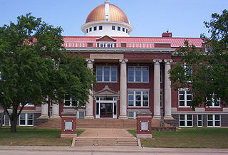
Lawton is a city in and the county seat of Comanche County, in the U.S. state of Oklahoma. Located in southwestern Oklahoma, approximately 87 mi (140 km) southwest of Oklahoma City, it is the principal city of the Lawton, Oklahoma, metropolitan statistical area. According to the 2020 census, Lawton's population was 90,381, making it the sixth-largest city in the state, and the largest in Western Oklahoma.

Walton is a town in Delaware County, New York, United States. The population was 5,270 at the 2020 census. The town is in the west-central part of the county and contains the village of Walton. The town claims to be the "Scarecrow Capital of the World."
Four Corners is a place in Weston County, Wyoming, United States. It is located in northeastern Wyoming near the Bear Lodge Mountains, part of the Black Hills, at the intersection of U.S. Route 85 and Wyoming Highway 585. It is located north of Newcastle, southeast of Sundance, Wyoming, and southwest of Lead, South Dakota. Originally a stage station on the famous stagecoach road Cheyenne Black Hills Stage Route connecting Cheyenne and the Union Pacific Railroad with the gold fields of Deadwood, it is today the site of a small store, bed-and-breakfast ranches, vacation homes, and tourist camps.

The Chemehuevi Mountains are a mountain range that are found at the southeast border of San Bernardino County in southeastern California and are adjacent the Colorado River. Located south of Needles, California and northwest of the Whipple Mountains, the mountains are oriented in a north–south direction, and stretch for approximately 15 miles (24 km) in length.
Wissinoming is a neighborhood in the Near Northeast section of Philadelphia, United States. It was the site of locomotive builder Matthias Baldwin's estate "Wissinoming", which was located near Tacony and Van Kirk Streets. The current Wissinoming is bordered by Mayfair on the west and Tacony on the north, Bridesburg on the south, I-95 and the Delaware River on the east, and Frankford on the southwest. Wissinoming has two ZIP codes: 19124 and 19135. Physical boundaries are: Levick Street on the north, Bridge Street on the south, I-95 and the Delaware River on the east, and Frankford Avenue on the west.

Southwest Oklahoma is a geographical name for the southwest portion of the state of Oklahoma, typically considered to be south of the Canadian River, extending eastward from the Texas border to a line roughly from Weatherford, to Anadarko, to Duncan. Geologically, the region is defined by a failed continental rift known as the Southern Oklahoma Aulacogen. The austere nature of the prairie landscape with intermittent island ranges has made it a favorable place for artists and photographers alike. For tourism purposes, the Oklahoma Tourism and Recreation Department has designated Southwestern Oklahoma as Great Plains Country, and defined it to consist of 14 counties including Roger Mills, Custer, Beckham, Washita, Caddo, Kiowa, Greer, Harmon, Jackson, Comanche, Tillman, Cotton, Stephens, and Jefferson counties.
Ingraham Hill is a mountain in the Southern Tier of New York. It is located south-southwest of Binghamton in Broome County. The mountain contains the television and radio broadcast towers for the surrounding metropolitan area. The summit rises to an elevation of 1,824 feet (556 m). These towers include TV stations WBNG, WICZ, WIVT, WSKG-TV and radio stations WNBF, WAAL, WWYL and many more. The towers are visible throughout the region.
Alander Mountain is a 2,241-foot-tall (683 m) part of the south Taconic Mountains in southwest Massachusetts and adjacent to New York. The summit is grassy and covered with scrub oak and shrubs; the sides of the mountain are heavily forested. Several trails traverse Alander Mountain, most notably is the 15.7 mi (25.3 km) South Taconic Trail, which passes just beneath the summit.
Red House Hill is a mountain in the Central New York Region of the State of New York, United States. It is located south-southwest of the Hamlet of Springfield Center, New York, west of Hutter Point and Six Mile Point of Otsego Lake, and southeast of Rum Hill. Mohican Brook flows eastward along the southern edge of the hill.
Lawton is an unincorporated community in Susquehanna County, Pennsylvania, United States. The community is located along Pennsylvania Route 267, Pennsylvania Route 367, and Pennsylvania Route 706, 10.5 miles (16.9 km) west-southwest of Montrose. Lawton has a post office with ZIP code 18828.
Frost Hill is a mountain in the Finger Lakes Region of New York. It is located west of Bristol Springs in Ontario County. At an elevation of 2,284 feet (696 m), the mountain is the highest point in Ontario County. It is about 1.25 miles (2.01 km) southwest of the 2,150-foot (660 m) Worden Hill, where Bristol Mountain Ski Resort is.
Sherman Hill is a mountain located in the Catskill Mountains of New York south-southwest of Franklin. Gallop Hill is located south-southwest, Lawton Hill is located west, and Johnson Hill is located east-southeast of Sherman Hill.
Wheat Hill is a mountain located in the Catskill Mountains of New York southwest of Franklin. Lawton Hill is located east, Hodges Hill is located south and Vandervort Hill is located west of Wheat Hill.
Van Loan Hill is a mountain in Greene County, New York. It is located in the Catskill Mountains southwest of Maplecrest. Round Hill is located west, Elm Ridge is located north-northeast, and East Jewett Range is located south of Van Loan Hill.

