Lincoln, Polk County, Wisconsin

Last updated

Lincoln, Wisconsin
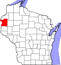
WIMap-doton-Lincoln i.png
Location of Lincoln, Polk County, Wisconsin
Coordinates: 45°19′58″N92°21′9″W / 45.33278°N 92.35250°W / 45.33278; -92.35250
Country Flag of the United States.svg  United States
State Flag of Wisconsin.svg  Wisconsin
County Polk
Area
  Total38.4 sq mi (99.4 km2)
  Land35.7 sq mi (92.5 km2)
  Water2.7 sq mi (6.9 km2)
Elevation
[1]
1,119 ft (341 m)
Population
 (2000)
  Total2,304
  Density64.5/sq mi (24.9/km2)
Time zone UTC-6 (Central (CST))
  Summer (DST) UTC-5 (CDT)
Area code(s) 715 & 534
FIPS code 55-44475 [2]
GNIS feature ID1583568 [1]

Lincoln is a town in Polk County, Wisconsin, United States. The population was 2,304 at the 2000 census. The unincorporated community of Deronda is located in the town.

Contents

Geography

According to the United States Census Bureau, the town has a total area of 38.4 square miles (99.4 km2), of which, 35.7 square miles (92.5 km2) of it is land and 2.7 square miles (6.9 km2) of it (6.93%) is water.

Demographics

As of the census [2] of 2000, there were 2,304 people, 864 households, and 671 families residing in the town. The population density was 64.5 people per square mile (24.9/km2). There were 1,119 housing units at an average density of 31.3 per square mile (12.1/km2). The racial makeup of the town was 98.78% White, 0.04% African American, 0.26% Native American, 0.39% Asian, 0.09% from other races, and 0.43% from two or more races. Hispanic or Latino of any race were 0.52% of the population.

There were 864 households, out of which 34.0% had children under the age of 18 living with them, 68.5% were married couples living together, 5.8% had a female householder with no husband present, and 22.3% were non-families. 17.6% of all households were made up of individuals, and 5.9% had someone living alone who was 65 years of age or older. The average household size was 2.67 and the average family size was 3.02.

In the town, the population was spread out, with 25.9% under the age of 18, 6.2% from 18 to 24, 26.6% from 25 to 44, 28.0% from 45 to 64, and 13.3% who were 65 years of age or older. The median age was 40 years. For every 100 females, there were 103.0 males. For every 100 females age 18 and over, there were 102.9 males.

The median income for a household in the town was $45,904, and the median income for a family was $48,500. Males had a median income of $37,366 versus $23,796 for females. The per capita income for the town was $21,788. About 5.2% of families and 6.3% of the population were below the poverty line, including 9.9% of those under age 18 and 2.3% of those age 65 or over.

Related Research Articles

<span class="mw-page-title-main">Good Hope, Alabama</span> City in Alabama, United States

Good Hope is a city in Cullman County, Alabama, United States. As of the 2010 census, the population of the city was 2,264. It incorporated in April 1962.

<span class="mw-page-title-main">Riverside, Alabama</span> City in Alabama, United States

Riverside is a city in St. Clair County, Alabama, United States. It incorporated in 1886. At the 2010 census the population was 2,208, up from 1,564 in 2000.

<span class="mw-page-title-main">Rosedale, California</span> Census-designated place in California, United States

Rosedale is a census-designated place (CDP) in Kern County, California, United States. The population was 14,058 at the 2010 census, up from 8,445 at the 2000 census. Formerly a country town 10 miles (16 km) west of Bakersfield, it is now surrounded by suburban housing and currently has the highest household income in Kern County, according to Census estimates.

<span class="mw-page-title-main">Waverly, Florida</span> Census-designated place in Florida, United States

Waverly is a census-designated place (CDP) in east-central Polk County, Florida, United States. The population was 1,927 at the 2000 census. It is part of the Lakeland–Winter Haven Metropolitan Statistical Area.

<span class="mw-page-title-main">Mulberry, Indiana</span> Town in Indiana, United States

Mulberry is a town in Madison Township, Clinton County, Indiana, United States. The population was 1,231 at the 2020 census. The town was named for a mulberry tree which grew at the point where it was founded.

<span class="mw-page-title-main">Van Buren, Indiana</span> Town in Indiana, United States

Van Buren is a town in Van Buren Township, Grant County, Indiana, United States. The population was 864 at the 2010 census.

<span class="mw-page-title-main">Lyons, Indiana</span> Town in Indiana, United States

Lyons is a town in Washington Township, Greene County, Indiana, United States. The population was 742 at the 2010 census. It is part of the Bloomington, Indiana Metropolitan Statistical Area.

<span class="mw-page-title-main">Rising Sun, Indiana</span> City in Indiana, United States

Rising Sun is a city in Randolph Township and the county seat of Ohio County, Indiana, United States, along the Ohio River. It is also the only incorporated community in the county. The population of Rising Sun was 2,304 at the 2010 census.

<span class="mw-page-title-main">Winslow, Indiana</span> Town in Indiana, United States

Winslow is a town in Patoka Township, Pike County, in the U.S. state of Indiana. The population was 864 at the 2010 census. It is part of the Jasper Micropolitan Statistical Area.

<span class="mw-page-title-main">Eagle Lake, Maine</span> Town in the state of Maine, United States

Eagle Lake is a town in Aroostook County, Maine, United States. The population was 772 at the 2020 census. The town was named by a body of troops heading from Bangor to the Aroostook War for the many eagles that they saw around the lake. A total of 49.0% of the population speaks French, reflecting a trend in Northeastern Maine.

<span class="mw-page-title-main">Mapleton, Maine</span> Town in the state of Maine, United States

Mapleton is a town in Aroostook County, Maine, United States. The population was 1,886 at the 2020 census.

<span class="mw-page-title-main">Otisville, Michigan</span> Village in Michigan, United States

Otisville is a village in Forest Township, Genesee County in the U.S. state of Michigan. The population was 864 at the 2010 census. It is located along M-15, just south of M-57. It is part of the Flint metropolitan area.

<span class="mw-page-title-main">Maplewood, Minnesota</span> City in Minnesota, United States

Maplewood is a city in Ramsey County, Minnesota, United States. The population was 42,088 at the 2020 census. Maplewood is ten minutes' drive from downtown Saint Paul. It stretches along the northern and eastern borders of Saint Paul.

<span class="mw-page-title-main">Hanley Hills, Missouri</span> Village in Missouri, United States

Hanley Hills is a village in St. Louis County, Missouri, United States. The population was 2,101 at the 2010 census.

<span class="mw-page-title-main">East Norwegian Township, Pennsylvania</span> Township in Pennsylvania, United States

East Norwegian Township is a township in Schuylkill County, Pennsylvania, United States. The population was 864 at the 2020 census.

<span class="mw-page-title-main">Tunnelton, West Virginia</span> Town in West Virginia, United States

Tunnelton is a town in southwestern Preston County, West Virginia, United States. The population was 307 at the 2020 census. It is part of the Morgantown metropolitan area.

<span class="mw-page-title-main">New Chester, Wisconsin</span> Town in Wisconsin, United States

he Town of New Chester is located in Adams County in the U.S. state of Wisconsin. The population was 2,254 at the time of the 2010 census, up from 864 at the time of the 2000 census. The unincorporated communities of Brooks and Grand Marsh are located in the town. The ghost town of New Chester is also located in the town.

<span class="mw-page-title-main">Sandwich (CDP), Massachusetts</span> Census-designated place in Massachusetts, United States

Sandwich is a village and census-designated place (CDP) in the town of Sandwich in Barnstable County, Massachusetts, United States. The population was 2,962 at the 2010 census, out of a total 20,675 people in the town of Sandwich.

<span class="mw-page-title-main">River Falls (town), Wisconsin</span> Town in Wisconsin, United States

River Falls is a town in Pierce County, Wisconsin, United States. The population was 2,304 at the 2000 census. The City of River Falls is located mostly within the town.

<span class="mw-page-title-main">Walworth, Wisconsin</span> Village in Wisconsin, United States

Walworth is a village in Walworth County, Wisconsin, United States. The population was 2,759 at the 2020 census. The village is located within the Town of Walworth.

References

  1. 1 2 "US Board on Geographic Names". United States Geological Survey. October 25, 2007. Retrieved January 31, 2008.
  2. 1 2 "U.S. Census website". United States Census Bureau . Retrieved January 31, 2008.