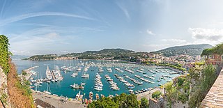
The Italian Riviera or Ligurian Riviera is the narrow coastal strip in Italy which lies between the Ligurian Sea and the mountain chain formed by the Maritime Alps and the Apennines. Longitudinally it extends from the border with France and the French Riviera near Ventimiglia eastwards to Capo Corvo which marks the eastern end of the Gulf of La Spezia and is close to the regional border between Liguria and Tuscany. The Italian Riviera thus includes nearly all of the coastline of Liguria. Historically the "Riviera" extended further to the west, through what is now French territory as far as Marseille.

Ascoli Piceno is a comune (municipality) and capital of the province of Ascoli Piceno, in the Italian region of Marche.
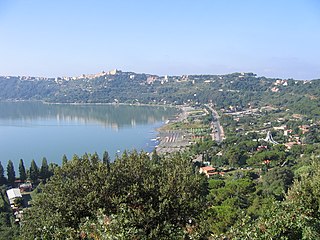
Castel Gandolfo, colloquially known as Castello in the Castelli Romani dialects, is a town located 25 km (16 mi) southeast of Rome, in the Italian region of Lazio. Situated on a hilltop in the Alban Hills with panoramic views of Lake Albano, Castel Gandolfo is home to approximately 8,900 residents and is renowned as one of Italy's most scenic towns. It is one of I Borghi più belli d'Italia.

Palio is the name given in Italy to an annual athletic contest, very often of a historical character, pitting the neighbourhoods of a town or the hamlets of a comune against each other. Typically, they are fought in costume and commemorate some event or tradition of the Middle Ages and thus often involve horse racing, archery, jousting, crossbow shooting, and similar medieval sports. Once purely a matter of local rivalries, many have now become events that are staged with an eye to visitors and foreign tourists.

Giorgio da Sebenico or Giorgio Orsini or Juraj Dalmatinac was a Venetian sculptor and architect from Dalmatia, who worked mainly in Sebenico, and in the city of Ancona, then a maritime republic.
Nocera Superiore is a town and comune in the province of Salerno in the Campania region of south-western Italy.

Roccapiemonte is a town and comune in the province of Salerno in the Campania region of south-western Italy.

Via dei Tribunali is a street in the old historic center of Naples, Italy.
This is an alphabetical list of the 7,918 Italian municipalities (comuni). These represent the fundamental municipal units of the local government system of the country.

La Storta is the 51st zona of the Italian capital city, Rome. It is identified by the initials Z. LI and falls within the boundaries of Municipio XV.
The Agro Nocerino-Sarnese or Agro Sarnese-Nocerino is a geographical region of the Province of Salerno, in Campania in southern Italy; the river Sarno flows through it. It is a low-lying area bounded to the south by the Monti Lattari, to the east and north-east by the Monti Picentini and to the west by the plain of Vesuvius. It consists of sixteen comuni: Angri, Bracigliano, Castel San Giorgio, Corbara, Nocera Inferiore, Nocera Superiore, Pagani, Roccapiemonte, San Marzano sul Sarno, San Valentino Torio, Santa Maria la Carità, Sant'Antonio Abate, Sant'Egidio del Monte Albino, Sarno, Scafati and Siano. All are in the province of Salerno except Santa Maria la Carità and Sant'Antonio Abate, which are in the province of Naples.
The Decumano or Decumanus Superiore was one of the three main east-west roads (Decumani) in the Ancient Roman city of Naples.
Team MBH Bank Colpack Ballan is an Italian cycling team based in Bergamo, Italy.

The strada statale 18 "Tirrena Inferiore" an Italian state highway 406.15 kilometres (252.37 mi) long in Italy located in the regions of Campania, Basilicata and Calabria. It is among the longest and most important state highways in southern Italy, considering that it follows the Tyrrhenian coast, from Salerno to Reggio di Calabria.

Giovanni Scanzi was an Italian sculptor. His early apprenticeship led to formal studies in Rome, followed by a career as a prolific artist and teacher. He was particularly active creating monuments for the Monumental Cemetery of Staglieno in Genoa, with many other works located in museums, churches and public venues in Genoa and elsewhere.
This page is based on this
Wikipedia article Text is available under the
CC BY-SA 4.0 license; additional terms may apply.
Images, videos and audio are available under their respective licenses.


