List of caves of Maryland

Last updated

This is a List of caves of Maryland. Maryland has numerous caves, with the greatest concentration in its western counties: Washington, Allegany, and Garrett.

Contents

Research on the topic

There are a number of sources about the topic area, including a reference book titled Caves of Maryland which was first released by the Maryland Geological Survey (MGS) in 1950. But information about Maryland caves was first gathered into a series of reports by Martin Muma in the mid-1940s, working under the MGS. After the release of these articles in 1946, a more comprehensive study was begun by William Davies, whose years of fieldwork led to the compilation of the premiere edition of Caves of Maryland in 1950. [1] Following the release of the first edition of Caves of Maryland in 1950, several other attempts by various parties and interested groups have been made at expanding available information concerning Maryland's subterrain. In the late 1960s the MGS sponsored another statewide survey, undertaken by Richard Franz and Dennis Slifer, and a second, expanded edition of Caves of Maryland was released in 1971. It was not until the inception of this second project that areas west of Washington County were even thoroughly canvassed; even after the conclusion of the Franz/Slifer survey, it was speculated that even more, undiscovered caves could still remain in more remote portions of the western counties, prompting the need for an additional version, but since that time there have been no additional state sponsored reports or surveys released to the public.

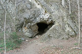
In Maryland, a cave is defined as any subterranean cavity large enough for a human to enter. [2] This definition has led the authors to include several shelter caves, fissures, and mines that in states with larger, more complex cave systems, might otherwise go unlisted.

Maryland geology and caves

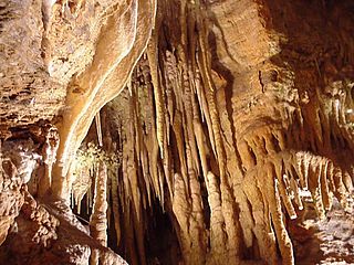
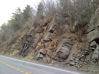
Most of Maryland's caves occur in its three westernmost counties (Washington, Allegany, and Garrett). While Maryland may be smaller than many of its neighboring states containing larger numbers of caves, its geology likewise allows for the formation of caverns, most of which are hollowed out by chemical processes—these caves are known as solutional caves. Non-solutional caves are carved out by weathering and are typically of smaller size and of little interest to spelunkers. Underlying layers of carbonate rocks form much of Maryland's bedrock. Precipitation and groundwater react with such rocks as dolomite, limestone, and marble, dissolving the rock and forming small fissures and chambers allowing more water to enter and the dissolve the carbonic rock. Being able to identify the different types of rock that caves are likely to form in can provide a great deal of background into a cave's likely history, and thus these rock formations will be further discussed moving east to west across the state.

Coastal Plain – this is the area of Maryland extending from just west of the Chesapeake Bay to the Atlantic Ocean: Precambrian rocks are mostly overlain by gravel, silts, marls, and sands, and consequently no solutional caves are known to exist in this region of Maryland.

Piedmont Plateau – an area of gently rolling hills and flatlands, the Piedmont is home to only a few of Maryland's caves, as most of its members are unsuitable for their development or are largely hidden from view beneath surface settlement. Exceptions in the uplands area include the Wakefield and Cockeystown marbles, which are known to include but a few caves. In the lowlands portion of the Piedmont (known as the Frederick Valley) caves are found in the Frederick Formation and Grove Limestone (upper Cambrian and lower Ordovician, respectively). Several other limestone members exist (Tomstown and New Oxford), no caves have been located within these members.

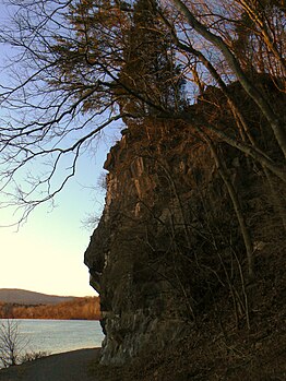
Blue Ridge & the Great Valley – the Blue Ridge rises up from the Piedmont just west of Frederick in the first of its two mountains, Braddock/Catoctin. Here older limestone and dolomites from the Cambrian/Ordovician make an appearance, offering up a few caves in the Frederick/Middletown Valley vicinity. On top of these, older, harder thrust sheets of metamorphic rocks from the Paleozoic give these mountains their well-defined crests and ridges. Wolf Rock, home to Maryland's best-known non-solutional cave, is an example of quartzite that has endured while Catoctin Mountain has weathered around it.

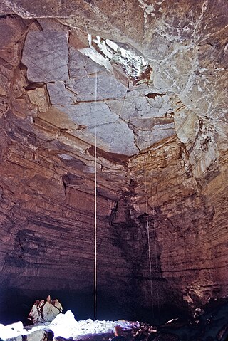
South Mountain, which serves as a natural border between Frederick and Washington counties, is the western edge of Maryland's Blue Ridge, giving way to an area of relatively little relief, known as the Great Valley (or locally as Hagerstown/Cumberland). Here the harder metamorphosed rocks of the Blue Ridge are replaced by carbonates, sandstones, and shale that grow progressively younger moving west, entering the early Ordovician period. The highest concentration of Maryland caves lies within the Hagerstown Valley, where well-established waterways have cut into the underlying carbonate rocks. Recent fieldwork, combined with the observations of Franz and Slifer, indicate that the most cavernous units exposed in the Great Valley are, from oldest to youngest, the Tomstown Dolomite, the Cavetown member of the Waynesboro Formation, the lower beds of the Elbrook Formation, the Rockdale Run Formation, and, especially cavernous, the Chambersburg Formation. The probability of cave development, however, is also very strongly influenced by the presence of structural features such as anticlinal axes, synclinal troughs, and faults. In contrast to the larger caves of neighboring West Virginia, caves in the Great Valley are generally quite shallow with little internal relief. In-cave relief rarely exceeds 50 feet (15 m) in Washington County. High deformation and faulting allows surface waters to penetrate rock vertically and reach the shallow underlying water table quickly without much lateral travel. This serves to limit cavern development considerably, and of the many caves in Washington County, only Crystal Grottoes is known to exceed 1,000 feet (300 m) in length, and it attains such length from having a maze pattern of passages, rather than a long continuous stream conduit.

Ridge & Valley Region – is the name of the physiological province extending west of the Great Valley to the western portion of Allegany County. This region is traditionally defined as starting at Fairview Mountain and is characterized by repeating southwest- to northeast-trending ridges and valleys. A thrust fault just east of Fairview indicates where younger rocks from the Ordovician through Devonian were overthrust by their Cambrian neighbors to the east. The region is built upon shale and sandstone from the upper Ordovician and lower Silurian periods, with little or no cave-bearing limestone seen until the lower Helderberg Group, Wills Creek Formation and Tonoloway Formation. Thicker formations of the upper Devonian consist of the Keyser Formation and New Creek Limestone, in which some of the largest caves in the state can be found.

Allegany Plateau – the Allegany is a rolling upland punctuated by deep, rounded valleys and ridges of distinct, broad anticlines. Shale and sandstone of the Ordovician and lower Silurian are replaced by limestone formations which continue into the lower Devonian. These younger rocks have settled to a depth equal to that of the much older rocks of the Ordovician. This change in depth occurs along a fault just east of Dans Mountain. Moving west from outcrops of early Devonian limestone, the Helderbergian limestones pinch out and the formation consists of clastic rocks that bear no caves. Synclines within this region have preserved remains from the younger Carboniferous Period—the period containing Maryland's only natural source of carbon fuels—within the Mississippian system lies the Greenbrier Formation, the next oldest limestone member known to contain caves. The Greenbrier is relatively thin but contains eight known large caves, including the largest cave in Maryland, Tanglefoot Cave. The youngest rocks to contain caves are in Garrett County: they are Pennsylvanian in age. All younger sediments have been removed from the landscape with the exception of the Dunkard Group, a small knob in Allegany County that is Permian in age.

List of caves

All caves given in the 1950 publication of Caves of Maryland are listed below by county. [3]

Allegany County

Baltimore County

Carroll County

Frederick County

Garrett County

Howard County

Washington County

Dam #4 Cave Dam-4Cave.JPG
Dam #4 Cave
Thrust sheet of Conococheague limestone near Fairview Fairview Caves1.JPG
Thrust sheet of Conococheague limestone near Fairview
Howell Cave Howell Cave MD.jpg
Howell Cave
"The Face" is surrounded by small caves near Two Locks TwoLocksCaveCliff.JPG
"The Face" is surrounded by small caves near Two Locks

Related Research Articles

Cave Natural underground space large enough for a human to enter

A cave or cavern is a natural void in the ground, specifically a space large enough for a human to enter. Caves often form by the weathering of rock and often extend deep underground. The word cave can also refer to much smaller openings such as sea caves, rock shelters, and grottos, though strictly speaking a cave is exogene, meaning it is deeper than its opening is wide, and a rock shelter is endogene.

Crystal Cavern(s), also known throughout the years as Alabama Caverns and McClu(n)ney Cave, is a small cavern containing crystal formations located in Clay, Alabama, USA.

Allegany State Park State park in New York state, United States

Allegany State Park is a state park in western New York State, located in Cattaraugus County just north of the Allegheny National Forest in Pennsylvania. The park is divided into two sections: The Red House Area and the Quaker Run Area. It lies within the Allegheny Highlands forests ecoregion.

Natural Bridge Caverns United States historic place

The Natural Bridge Caverns are the largest known commercial caverns in the U.S. state of Texas. The name is derived from the 60 ft natural limestone slab bridge that spans the amphitheater setting of the cavern's entrance. The span was left suspended when a sinkhole collapsed below it.

Blanchard Springs Caverns

Blanchard Springs Caverns is a cave system located in the Ozark–St. Francis National Forest in Stone County in northern Arkansas, 2 miles off Highway 14 a short distance north of Mountain View. It is the only tourist cave owned by the United States Forest Service and the only one owned by the Federal government outside the National Park System. Blanchard Springs Caverns is a three-level cave system, all of which can be viewed on guided tours. The Dripstone Trail runs through the uppermost level of caverns for about a half-mile and opened in 1973. The Discovery Trail opened in 1977 and loops through a 1.2-mile section of the cavern, descending to the lower level of the cave, 366 feet underground, as well as to the Natural Entrance, about 100 feet below ground at that point, following the stream bed of the springs that created the cavern. This trail includes the Rimstone Dams, which create pools along the stream bed, and the Ghost Room, a small but very well decorated room in the uppermost level, with its huge white flowstone. Also offered is a "Wild Cave" tour which allows access to undeveloped parts of the cave to more adventurous visitors. It follows the upstream section of the cave, allowing visitors to see all three levels as the original explorers did, continuing beyond where the Discovery Trail ends.

Delaware Basin Geologic depositional and structural basin in West Texas and southern New Mexico

The Delaware Basin is a geologic depositional and structural basin in West Texas and southern New Mexico, famous for holding large oil fields and for a fossilized reef exposed at the surface. Guadalupe Mountains National Park and Carlsbad Caverns National Park protect part of the basin. It is part of the larger Permian Basin, itself contained within the Mid-Continent oil province.

Marvel Cave

Marvel Cave is a National Natural Landmark located just west of Branson, Missouri, on top of Roark Mountain in Stone County. The cave was known by the Osage Indians in the early 16th century, after a tribe member fell through the cave's main entrance, a sinkhole. There is evidence that in 1541 the Spanish explored the cave, but the first recorded expedition was in 1869, led by Henry T. Blow. The unofficial Stone County chapter of Bald Knobbers, a local group of vigilantes, were rumored to have taken people to the top of Roark Mountain, and thrown them in the sink hole.

Carlsbad Caverns National Park National Park in New Mexico, United States

Carlsbad Caverns National Park is an American national park in the Guadalupe Mountains of southeastern New Mexico. The primary attraction of the park is the show cave, Carlsbad Cavern. Visitors to the cave can hike in on their own via the natural entrance or take an elevator from the visitor center.

Germany Valley

Germany Valley is a scenic upland valley high in the Allegheny Mountains of eastern West Virginia originally settled by German farmers in the mid-18th century. It is today a part of the Spruce Knob-Seneca Rocks National Recreation Area of the Monongahela National Forest, although much ownership of the Valley remains in private hands.

Hellhole (cave)

Hellhole is a large and deep pit cave in Germany Valley, eastern West Virginia. It’s the 7th longest cave in the United States and is home to almost half of the world's population of Virginia big-eared bats. At 737 feet, Hellhole is the deepest of several caves in the Valley.

Crystal Grottoes

Crystal Grottoes is the only show cave in the U.S. state of Maryland. It is located on Maryland Route 34 between Boonsboro and Antietam National Battlefield.

Eleven Jones Cave is located by Beargrass Creek in Louisville, Kentucky. It is 1,600 feet (490 m) southeast of the corner of Eastern Parkway and Poplar Level Road on the west bank, between Louisville Cemetery and Calvary Cemetery, near St. Xavier High School. It is developed in Louisville Limestone 448 feet above sea level. A spring discharges water into Beargrass Creek.

Wills Creek Formation Bedrock unit in the Eastern United States

Wills Creek Formation is a mapped Silurian bedrock unit in Pennsylvania, Maryland, Virginia, and West Virginia.

Indian Springs is an unincorporated community in western Washington County, Maryland, United States. Its population was 64 as of the 2010 census.

Tongue River Cave

Tongue River Cave is a cave in the Bighorn National Forest just west of Dayton, Wyoming. Historically notable for a wide variety of rare cave formations and animal species, the cave has suffered in recent decades from unrestricted traffic, vandalism, and the theft of many of the cave's speleothems. Deemed beyond preservation, the cave is now managed by the U.S. Forest Service as a "sacrifice cave".

Keyser Formation

The Late Silurian to Early Devonian Keyser Formation is a mapped limestone bedrock unit in Pennsylvania, Maryland, Virginia, and West Virginia.

The geology of Monmouthshire in southeast Wales largely consists of a thick series of sedimentary rocks of different types originating in the Silurian, Devonian, Carboniferous, Triassic and Jurassic periods.

Ash Hole Cavern Cave in Brixham, Devon, England

Ash Hole Cavern is a limestone cave system in Brixham, Devon, England. There is evidence of human habitation since Neolithic times, and archaeological excavations have been conducted, with several artefacts found. It has been a scheduled monument since 1966.

The geology of Utah includes rocks formed at the edge of the proto-North American continent during the Precambrian. A shallow marine sedimentary environment covered the region for much of the Paleozoic and Mesozoic, followed by dryland conditions, volcanism and the formation of the basin and range terrain in the Cenozoic. Utah is a state in the western United States.

The Bertie Group or Bertie Limestone, also referred to as the Bertie Dolomite and the Bertie Formation, is an upper Silurian geologic group and Lagerstätte in southern Ontario, Canada, and western New York State, United States. Details of the type locality and of stratigraphic nomenclature for this unit as used by the U.S. Geological Survey are available on-line at the National Geologic Map Database. The formation comprises dolomites, limestones and shales and reaches a thickness of 495 feet (151 m) in the subsurface, while in outcrop the group can be 60 feet (18 m) thick.

References

  1. Maryland Geological Survey's Caves of Maryland, 1971
  2. Virginia Region of the NSS Archived 2008-08-28 at the Wayback Machine Maryland Cave Law [ dead link ]
  3. 1 2 3 4 5 6 7 8 9 10 11 12 13 14 15 16 17 18 19 20 21 22 23 24 25 26 27 28 29 30 31 32 33 34 35 36 37 38 39 40 41 42 43 44 45 46 47 48 49 Davies, William (1950). The Caves of Maryland - Bulletin 7 (PDF). State of Maryland - Department of Geology, Mines and Water Resources. Retrieved 2019-09-27.{{cite book}}: CS1 maint: postscript (link)
  4. "Devil's Hole Cave, Allegany County". Maryland Geological Survey.
  5. "Greises Cave, Allegany County". Maryland Geological Survey.
  6. "Rocky Gap Cave, Allegany County". Maryland Geological Survey.
  7. "Twiggs Cave, Allegany County". Maryland Geological Survey.
  8. "Monocacy River Cave, Frederick County". Maryland Geological Survey.
  9. The Nature Conservancy Archived 2008-11-30 at the Wayback Machine Crabtree Cave