MacGillycuddy's Reeks (Irish: Na Cruacha Dubha, meaning 'the black stacks') is a sandstone and siltstonemountain range in the Iveragh Peninsula in County Kerry, Ireland. Stretching 19 kilometres (12 miles), from the Gap of Dunloe in the east, to Glencar in the west, the Reeks is Ireland's highest mountain range, and includes most of the highest peaks and sharpest ridges in Ireland, and the only peaks on the island over 1,000 metres (3,300 feet) in height.
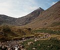
Near the centre of the range is Carrauntoohil, Ireland's highest mountain at 1,038.6 metres (3,407ft). The range was heavily glaciated which carved out deep corries (e.g. the Eagle's Nest), U-shaped valleys (e.g. Lough Coomloughra), and sharp arêtes and ridges (e.g. the Beenkeragh Ridge).[2]
The range, part of the Reeks District, is a destination for mountain walkers and climbers and includes some of Ireland's most regarded walking routes such as the 15–kilometre (10 mile) Coomloughra Horseshoe, and the 26-kilometre (16 mile) MacGillycuddy's Reeks Ridge Walk that traverses the full range; it is estimated that over 140,000 people visit the range each year.[3] The entire range is in private ownership; however, reasonable access is given for recreational use.[2][3]
Geology
MacGillycuddy's Reeks are composed of sandstone particles of various sizes, which are collectively known as the Old Red Sandstone. The rocks date from the Upper Devonian period (310–450 million years ago) when Ireland was in a hot equatorial setting.[2] During this 60 million year period, Ireland was the site of a major basin, known as the Munster basin, and the counties of Cork and Kerry were effectively a large alluvial floodplain.[2] Chemical oxidation stained the material with a purple–reddish colour (and green in places from chlorination), still visible today.[2] There are virtually no fossils in Old Red Sandstone.[2] The composition of Old Red Sandstone is variable and contains quartz stones, mudstones, siltstones, and sandstone particles (boulders of conglomerate rock containing quartz pebbles are visible throughout the range).[2] The Reeks were also subject to significant glaciation which led to fracturing of the rock, and resulted in deep corries (e.g. the Eagle's Nest), U-shaped valleys (e.g. Lough Coomloughra), and sharp arêtes and ridges (e.g. the Beenkeragh Ridge).[2][4]
The Eastern Reeks meet the Coomloughea Reeks at the col of the Devil's Ladder, a popular ascent route for Carrauntoohil.[2]
MacGillycuddy's Reeks contains the three peaks in Ireland which are over 1,000 metres (3,300 feet) in height, namely: Carrauntoohil, Ireland's highest mountain at 1,038.6m (3,407ft), followed by Beenkeragh at 1,008m (3,307ft) and Caher at 1,000m (3,300ft).[6]
The range contains eleven of the fourteen peaks in Ireland that are over 3,000ft (910m) in height, and meet the Vandeleur-Lynam classification of a mountain—peaks with a prominence over 15m (49ft).[7] All but one of these eleven 3,000ft peaks, namely Cnoc an Chuillinn East Top, are amongst the list of thirteen Irish Furths—peaks which meet the Scottish Mountaineering Club's criteria for a Munro, and they are therefore also known as Irish Munros.[8]
There are 29 peaks in the range above 100m (330ft) in height.[6] The range contains 14 Irish Hewitts (height above 2,000ft and prominence above 30 metres; 100 feet),[9][6] and 16 Irish Arderins (height above 500 metres; 2000 feet and prominence above 30 metres; 100 feet).[10] The range is also known for its sharp aretes, including The Bones arete, more famously known as the Beenkeragh Ridge, and The Big Gun arete.[6]
A feature of the range is the modest topographic prominence, or "drop" between many of its peaks.[9][5] Only two of the eleven Reeks over 3,000ft meet the Marilyn classification of a mountain (a prominence above 150 metres; 500 feet), namely Carrauntoohil and Cnoc na Péiste.[9] The only Reek that meets the P600 classification (a prominence above 600 metres; 2000 feet), is Carrauntoohil itself.[9] The combination of high peaks and low prominence, means the ridges between the peaks are at a sustained height (e.g. why the prominence is so modest), which has contributed to the popularity of ridge walking in the Reeks, particularly, the Coomloughra Horseshoe, and the MacGillycuddy's Reeks Ridge Walk, and the term, "Ireland's highest mountain range".[5][6]
Ownership
The Reeks as viewed from Churchtown Cemetery, near Beaufort, in 1990
The entire range is held in private ownership, both in individually owned freehold parcels in the lower reaches and in commonly owned, open upland zones ('commonage'). A State-sponsored report into access for the range in December 2013 titled MacGillycuddy Reeks Mountain Access Development Assessment (also called the Mountain Access Project, or MAP), mapped the complex network of land titles.[4] Unlike many other national mountain ranges, the MacGillycuddy's Reeks are not part of a national park or a trust structure.[4][3]
The private ownership has led to issues around the upkeep of popular paths in the Reeks, most particularly the erosion of the Devil's Ladder path, which is used to summit Carrauntoohil; and various car-parks and bridges used by climbers.[11][4] The 2013 MAP report noted the importance of safety in light of the increasing climbers and walkers to the Reeks. The MAP report stated that Kerry Mountain Rescue ("KMR") logged 17 fatalities on the Reeks between 1966 and 2000, or about one every second year, but since 2000, KMR had been logging approximately 2 fatalities per annum.[2][3]
In 2019 the Irish Times reported that the MacGillycuddy Reeks Mountain Access Forum, a cross-body group of landowners, commercial users and public access and walking groups set up in 2014 with the aim of "protecting, managing and sustainably developing the MacGillycuddy's Reeks mountain range, while halting and reversing the obvious and worsening path erosion", had achieved some success laying down new pathways in the Hag's Glen approach to Carrauntoohil; however, the Irish Times still wondered, "Should the Kerry reeks be a national park?".[3]
The full name of the range in Irish is Cruacha Dubha Mhic Giolla Mo Chuda, meaning "the black stacks of McGillycuddy". This is commonly shortened to Na Cruacha Dubha.[12][13] The name is translated into English as "MacGillycuddy's Reeks",[13] where reek is a Hiberno-English form of the word rick, denoting a stack.[14]
The MacGillycuddys (Irish: Mhic Giolla Mo Chuda) were a sept, or branch, of the O'Sullivan Moore clan. The MacGillycuddy is recorded as being one of a smaller number of Gaelic chieftains whose lands were returned post the Cromwellian confiscations, which explains why the name survives to this day.[13] The MacGillycuddy family tomb is at Kilgobnet, County Kerry, between the mountains and Killorglin.[13] The clan chief, McGillycuddy of the Reeks, owned land in this part of Munster until the end of the 20th century.
Jim Ryan's 2006 book on the Reeks, Carrauntoohil and MacGillycuddy's Reeks: A Walking Guide to Ireland's Highest Mountains, stated that there were 25,000 annual visitors to the Reeks.[2] The 2013 MAP report quoted Ryan's figures, which were cited in the MAP's Terms of Reference, but stated that: "The Reeks are accessed by at least 25,000 recreational users per annum. It is highly likely that the numbers are a factor of 4 times higher based on observation of the year-round level of usage – but data is required to ascertain the visitor numbers."[4] It was estimated that 125,000 visitors entered the range in 2017 from footfall at three main access points,[11] and that 140,000 entered in 2018 by recording footfall at four main access points.[3] The Reeks are a popular subject for artists and photographers, with souvenir prints offered for sale among "Views of Ireland."[15][16]
The most common reason for visiting the Reeks is to climb Ireland's highest mountain, Carrauntoohil. The popular route starts from Cronin's Yard (V837873) and enters the Hag's Glen to climb the Devil's Ladder (the col between Carrauntoohil and Cnoc na Toinne), from which the summit is accessed.[5] A more challenging route is via the Hag's Tooth Ridge which circles the Eagle's Nest, and takes in Beenkeragh, and the Beenkeragh Ridge.[2]
MacGillycuddy's Reeks is particularly regarded for the quality of its ridge walking routes,[5] with the 6–8 hour 15 kilometres (9.3mi)Coomloughra Horseshoe, that circles Lough Coomloughra, considered "one of Ireland's classic ridge walks", which takes in all three of Ireland's 1,000 metres (3,300ft) peaks, namely, Carrauntoohil, Beenkeragh, and Caher (East Top and West Top), as well as the famous Beenkeragh Ridge.[17][18][5][2]
The most challenging route is the full MacGillycuddy's Reeks Ridge Walk, a 12- to 14-hour, 26-kilometre (16mi) traverse of the entire range.[2] The route normally starts at the eastern end from Kate Kearney's Cottage in the Gap of Dunloe.[19] The route takes in Stickeen Mountain (440 metres (1,440ft)) and Cnoc an Bhráca (731 metres (2,398ft)) before reaching the ridge proper at Cruach Mhór (932 metres (3,058ft)). From there it continues along the narrow arete of The Big Gun (939 metres (3,081ft)) to Cnoc na Péiste (988 metres (3,241ft)), and continuing along the chain of Maolán Buí (923 metres (3,028ft)), Cnoc an Chuillinn (958 metres (3,143ft)), Cnoc na Toinne (845 metres (2,772ft)) to the summit of Carrauntoohil (1,038 metres (3,406ft)).
From Carrauntoohil, a number of variations are possible, the main one being a detour to Beenkeragh (1,008 metres (3,307ft)) before returning along the same route to get to Caher (1,000 metres (3,300ft)) and then on to Caher West Top (975 metres (3,199ft)) before descending to the Hydro-Track (V772871) car park near Lough Acoose, Glencar.
An alternative variation is to continue from Beenkeragh on the northern side of the Coomloughra Horseshoe to the peaks or Skregmore (848 metres (2,782ft)) and Cnoc Íochtair (747 metres (2,451ft)) before descending to the Hydro-Track car park.[20][5][2]
Rock and winter climbing
Carruntoohil's northeastern corrie (Eagle's Nest), a winter climbing area.
MacGillycuddy's Reeks are not especially known for their rock-climbing routes, unlike Ailladie in Clare or Fair Head in Antrim. The 450 metres (1,480ft)rock climbing grade Very Difficult (V-Diff), Howling Ridge up the central arete between the east and north-east faces of Carrauntoohil is notable.[21][22][23] The north-east face of Carrauntoohil (e.g. the Eagle's Nest area), is better known for its winter climbing, conditions permitting, offering 80 routes with 7 up to winter Grade V.[24][25]
The following is a download from the MountainViews Online Database, which lists 29 identifiable Reeks with an elevation, or height, above 100 metres (330ft).[26]
Furth (or Irish Munro): Height over 3,000 feet (914m), and on the SMC Furth list.
Marilyn: Any height, and prominence over 150 metres (492ft).
↑ "Hill Lists: Furths". Scottish Mountaineering Club. Archived from the original on 5 October 2018. Retrieved 23 October 2018. The list of peaks of 3000ft or more within the United Kingdom and the Republic of Ireland outside (furth) of Scotland. There are currently 34 Furths.
↑ Paul Tempan (2006). "Irish mountain names and their international links". MountainViews Online Database. Cruach - 'stack, rick, pile': Given the original meaning of this word, it is not surprising that most of the mountains with names in cruach show a symmetrical triangular profile, rather like a haystack. This is very evident in the case of na Cruacha Dubha (MacGillycuddy's Reeks) or, to give them their full and rather poetic title, Cruacha Dubha Mhic Giolla Mochuda.
1 2 3 4 Paul Tempan (2006). "REVIEW: Jim Ryan - Carrauntoohil & MacGillycuddy's Reeks: A Walking Guide to Ireland's Highest Mountains". MountainViews Online Database. However, he makes no mention here, or elsewhere in the book, of the MacGillycuddys (a branch of O'Sullivan More), the family most intimately connected with the Reeks, as well as the area to the north, and which gave its name to the range (Cruacha Dubha Mhic Giolla Mo Chuda, usually shortened to just Na Cruacha Dubha, 'the black stacks'). The MacGillycuddy was one of the few Gaelic chieftains to have his lands restored after the Cromwellian confiscations, a circumstance which helps to explain why the name has survived to this day. The MacGillycuddy family tomb is at Kilgobnet, between the mountains and Killorglin.
↑ "The Macgillicuddy Reeks, Killarney County Kerry, Ireland". Library of Congress. Retrieved 16 January 2024. Title from the Detroit Publishing Co., catalogue J--foreign section. Detroit, Mich.: Detroit Photographic Company, 1905.. Print no. "12000". Forms part of: Views of Ireland in the Photochrom print collection.
↑ "Photochrom Prints". Library of Congress. 13 May 1890. Like postcards, the photochroms feature subjects that appeal to travelers, including landscapes, architecture, street scenes, and daily life and culture. The prints were sold as souvenirs and often collected in albums or framed for display.
↑ John O'Dwyer (20 June 2009). "Our Nation's Finest Mountain Route". Irish Times. There are a few candidates for this honour; Dingle's Brandon Ridge, Connemara's Glencoaghan Horseshoe and Mayo's Mweelrea Circuit immediately spring to mind. But nearly all hillwalkers now agree that one route stands out above even such splendour. Kerry's Coomloughra Horseshoe is virtually impossible to match in an Irish context, as it takes in our three highest summits and offers an adrenalin-filled crossing of a memorable mountain ridge, great long-range coastal views and a birds-eye panorama over some of Killarney's renowned lakes and fells.
↑ Con Moriarty (2018). "The Ridge of the Reeks". Hidden Ireland Tours. Simply, the finest mountain traverse in Ireland with 7 summits over 3000 ft. From Kate Kearney's Cottage, in the Gap of Dunloe, to Doire na Féinne and Loch a' Chúis
This page is based on this Wikipedia article Text is available under the CC BY-SA 4.0 license; additional terms may apply. Images, videos and audio are available under their respective licenses.