Hurricane Dorian was the strongest hurricane to affect The Bahamas on record,causing catastrophic damage on the islands of Abaco Islands and Grand Bahama,in early September 2019. The cyclone's intensity,as well as its slow forward motion near The Bahamas,broke numerous records. The fifth tropical cyclone,fourth named storm,second hurricane,and first major hurricane of the 2019 Atlantic hurricane season,[1][nb 1] Dorian originated from a westward-traveling tropical wave,that departed from the western coast of Africa on August19. The system organized into a tropical depression and later a tropical storm,both on August24.
The newly formed Dorian strengthened only gradually over the next few days because of dry air and vertical wind shear. On August27,Dorian made landfall in Barbados and St. Lucia before entering the Caribbean. Dorian's structure was seriously disrupted after encountering the mountains of St. Lucia,causing the system's center to reform north of its previous location. Moving farther north and east than anticipated,Dorian passed east of Puerto Rico on August28. Simultaneously,relaxing wind shear and warm sea surface temperatures allowed Dorian to become a Category1 hurricane as it moved over the United States Virgin Islands. Intensification temporarily stagnated on August29 before a spurt of rapid deepening began on August30. During this time,the hurricane turned west-northwestward,then westward,as a ridge built in the subtropics to the north. Dorian achieved Category5 intensity– the highest classification on the Saffir–Simpson scale– on September1. The system reached peak intensity later that day,with winds of 185mph (295km/h) and a central pressure of 910mbar (hPa;26.87inHg) while making landfall on Elbow Cay in The Bahamas.[nb 2]
Dorian weakened steadily throughout September2;the storm's forward momentum came to a crawl while it was crossing over Grand Bahama. The system fell below major hurricane status on September3,as it began to accelerate northwards. On September5,Dorian briefly reintensified into a Category3 hurricane,as it traversed the warm waters of the Gulf Stream. Increasing wind shear weakened Dorian once again,as it turned northeast and approached the Outer Banks. On September6,Dorian made landfall on Cape Hatteras as a low-end Category2 hurricane. As Dorian became increasingly influenced by the westerlies,it transitioned into a post-tropical cyclone on September7 just before passing over Nova Scotia. It then became fully extratropical the next day over the Gulf of Saint Lawrence and was absorbed by a larger extratropical cyclone on September9.
Origins and track through the Lesser Antilles
Hurricane Dorian originated from a large tropical wave– an elongated trough of low air pressure– that departed from the western coast of Africa on August19,2019.[3] Around that time,much of the wave's convection or thunderstorm activity was located inland near Guinea and Senegal rather than close to its center. Thunderstorms in the northern portion of the wave were limited by an abundance of Saharan dust in the region.[4] While the wave traveled westward across the low latitudes of the Atlantic,it lost most of its convection before a low-pressure area developed on August22. Despite being located in an area of moderate vertical wind shear,the system continued to increase in organization.[3] The National Hurricane Center (NHC),initially predicted slow development on August23 as the system continued westward.[5] However,the system organized into a tropical depression at 06:00UTC on August24,while approximately 805mi (1,295km) east-southeast of the island of Barbados.[3]
Early in the depression's existence,its southeastern outflow was restricted due to moderate easterly wind shear.[6] The system was upgraded into Tropical Storm Dorian at 18:00UTC after developing a 10-mile (15km) wide eye-like feature at its mid-levels and banding features that wrapped around it.[3][7] Dorian initially intensified while it was located in an environment of warm sea surface temperatures. This trend all but ceased over the next few days as a result of wind shear,as well as abundant mid-level dry air.[3][8] With little change in intensity,Dorian made landfall over Barbados around 01:30UTC on August27 with maximum sustained winds of 50mph (85km/h),entering the Caribbean.[3] At that time,composite radar showed that the system lacked a strong inner core.[9] The tropical storm made its second landfall on St. Lucia around 11:00UTC at the same intensity;the mountainous terrain of the island disrupted the low-level circulation of the system.[3] Soon after,Dorian's center re-developed farther north. Meanwhile,the storm's convection fluctuated as the system continued to be affected by dry air and interacted with the Leeward and Windward islands. Dorian briefly developed a 10-mile (15km) wide eye on radar on a couple occasions,but it quickly eroded because of mid-level dry air incursions.[10]
Dorian soon took a more northwesterly direction as a result of a weakness in a ridge,caused by a mid- to upper-level low (cold-core cyclone) located to the north of the island of Hispaniola.[11] Although Dorian was initially forecast to make landfall on Hispaniola and subsequently weaken or dissipate over the island,the system's track shifted east of Puerto Rico by August28 as a result of northerly directional change,as well as the center reformation.[3][10] Dorian's structure began to improve on the same day,with banding features becoming more prominent and a partial eyewall forming.[3][11] As Dorian strengthened into a Category1 hurricane on the Saffir–Simpson scale,it made landfall over St. Croix and St. Thomas in the United States Virgin Islands at 15:30UTC and 18:00UTC,respectively. Meanwhile,the cloud pattern of the tropical cyclone was continuing to increase in organization,with an eye becoming apparent on satellite imagery. The hurricane progressed northwestward under the influence of flow between an upper-level low over the Straits of Florida and the Atlantic subtropical ridge.[3] Additional strengthening was forecast as the storm would remain in a favorable environment with an increasingly moist mid-level,with sea temperatures near or over 84°F (29°C),and low wind shear. Even though the storm had strengthened and developed a more defined eye,[12] dry air and southwesterly wind shear caused Dorian's intensification to temporarily stagnate before decreasing again.[13] Later,on August29,a NOAA Hurricane Hunter aircraft reported the presence of concentric eyewalls,indicating that an eyewall replacement cycle had commenced. The aircraft also discovered that the central pressure had fallen. The plane did not find any stronger winds as Dorian continued to track towards the northwest.[14]
Rapid intensification and landfalls in the Bahamas
Hurricane Dorian at peak intensity while making landfall in the Abaco Islands on September1
By the morning of August30,Dorian completed the eyewall replacement cycle and resumed its intensification trend. The upper-level low steering the hurricane retreated to the south,while the Atlantic subtropical ridge built westward. This caused Dorian to track west-northwest into a highly favorable environment characterized by low wind shear,high relative humidity,[3] and sea surface temperatures of 84°F (29°C). The storm then moved west,straight towards the northwestern Bahamas.[15] Dorian reached major hurricane intensity at 18:00UTC on August30 about 445mi (715km) east of the northwestern Bahamas.[3] Later that evening,the eye of Dorian cleared out and became surrounded by a ring of deep convection. Meanwhile,a burst of lightning activity occurred in the northwest eyewall,heralding further intensification.[16][17] A Hurricane Hunter aircraft revealed that Dorian rapidly intensified to Category4 status at 00:00UTC on August31,with surface winds measured to be near 130mph (215km/h).[3][18] The satellite presentation of Dorian continued to improve,with the eye increasing in definition and stabilizing at a diameter of about 14 miles (23km). The eye also began to demonstrate a pronounced stadium effect,where the clouds of the eyewall curved outward from the surface with height;this is a feature at times seen in intense tropical cyclones.[3]
At 06:00UTC on September1,Dorian became a Category 5 hurricane with winds of 165mph (270km/h).[3] Around 12:00UTC,the NHC estimated the one-minute sustained winds to have reached 180mph (285km/h),making Dorian the strongest hurricane to impact The Bahamas on record. Just before 15:00UTC,a Hurricane Hunter aircraft in Dorian's eyewall measured flight-level winds of 183mph (294km/h) and its stepped frequency microwave radiometer recorded winds of up to 196mph (315km/h),while a dropsonde released by the aircraft recorded a surface wind gust of 203mph (326km/h).[19] Further deepening occurred over the next couple of hours,with maximum sustained winds reaching 185mph (295km/h) and the minimum central pressure dropping to 910mbar (hPa;26.87inHg),representing Dorian's peak intensity. At this strength,Dorian made landfall over Elbow Cay of the Abaco Islands at 16:40UTC September1,becoming the strongest hurricane to make landfall in The Bahamas in modern records.[3]
As Dorian crossed the Abaco Islands,a ridge to the north of the hurricane weakened. The steering flow hence diminished,causing Dorian to decelerate. Creeping slowly westwards,Dorian weakened slightly before making landfall near South Riding Point,Grand Bahama with winds of 180mph (285km/h) at 02:15UTC on September2. The system moved off the north coast of Grand Bahama six hours later,still as a Category5 hurricane,albeit with a larger eye and lower winds because of land interaction and an upwelling of cooler waters beneath the system.[3] These factors,coupled with Dorian's slow motion,caused steady weakening over the next couple of days,with Dorian dropping to Category3 status at 06:00UTC September3. Through this time,Dorian essentially stalled just north of Grand Bahama– from 12:00UTC September2 to 12:00UTC September3,Dorian traveled a distance of just 30 miles (48km). As a result,the entire island of Grand Bahama experienced winds of at least tropical-storm-force for three consecutive days.[3] Parts of Grand Bahama experienced the eyewall for more than 25hours,including 5hours while Dorian was at Category5 intensity;meanwhile Halls Point spent over 11hours within Dorian's eye.[20] During this period,Dorian brought an estimated 3.0ft (0.9m) of rain to The Bahamas,[21] along with a storm surge of over 20ft (6.1m).[3]
Hurricane Dorian making landfall in Hatteras,North Carolina as a Category2 hurricane,with maximum wind speeds of 100mph (155km/h)
Dorian began a northwestward motion late on September3 towards the eastern coast of the United States,as an eastward-moving mid-level trough over the Eastern United States pulled Dorian to the north.[3] At the same time,the eye had become cloud-filled,larger,and more ragged. Data collected by reconnaissance aircraft and buoys indicated that the wind field of the storm was expanding.[22] Dorian slowly weakened over the next day after entering an area of cooler sea surface temperatures and high wind shear.[3] The distinctness of the storm's eye waxed and waned as the system continued to pick up forward speed.[23][24] Soon after,clouds in the eyewall began to cool as Dorian began to restrengthen,[25] facilitated by the warm waters of the Gulf Stream.[3] After the eye cleared and became surrounded by deep convection,the hurricane reached its secondary peak intensity as a 115-mile-per-hour (185km/h) Category3 hurricane at 00:00UTC on September5,while located off the coast of Georgia.[3][26] After about 12 hours,Dorian began to gradually weaken as it traveled along the South Carolina coast.[27][28] Rapidly accelerating northeastward,Dorian made landfall over Cape Hatteras,North Carolina,as a Category2 hurricane,at approximately 12:30UTC on September6,with 100mph (155km/h) winds and a pressure of 957mbar (28.26inHg);North Carolina mainly experienced Category1 winds as the peak winds occurred primarily offshore.[3] Despite being significantly weaker,the storm still possessed a well-defined eye surrounded by deep convection.[29]
Early on September7,Dorian began to undergo the transition to an extratropical cyclone. The eye completely disappeared from satellite imagery as the storm began to take on a more asymmetric structure.[30] The hurricane's structure degraded due to strong southwesterly shear,with most of its convection displaced to the north and east of the center.[31] Soon after,cold air clouds began to entrain on Dorian's southwestern side,as the storm connected with a warm front that was developing to the northeast.[32] Dorian became a post-tropical cyclone around 18:00UTC on September7 after losing much of its tropical characteristics.[3][33] Despite this,the NHC opted to continue issuing advisories on the system,due to the threat it posed to Atlantic Canada.[33] At the time,an ASCAT pass showed a region of 90–100mph (150–155km/h) winds in the storm.[34] Dorian made landfall near Sambro Creek in Nova Scotia,Canada,at approximately 22:00UTC.[3] The storm gradually turned towards the east as it became embedded within the extratropical westerly flow.[35] The storm was deemed to have fully completed its extratropical transition over the Gulf of Saint Lawrence by 06:00UTC on September8.[3] Dorian's cloud pattern gradually decayed,with the storm weakening to tropical storm-force by 18:00UTC.[3][36][37] By September 9,virtually no significant convection existed near the center of Dorian. Soon after,the cyclone passed the Strait of Belle Isle and entered the northern Atlantic;sea surface temperatures were less than 50°F (10°C) in the nearby Labrador Sea. Dorian was ultimately absorbed by a larger extratropical cyclone at 06:00UTC on September9,while located northeast of Newfoundland.[3][38]
Records
Most intense landfalling Atlantic hurricanes Intensity is measured solely by central pressure
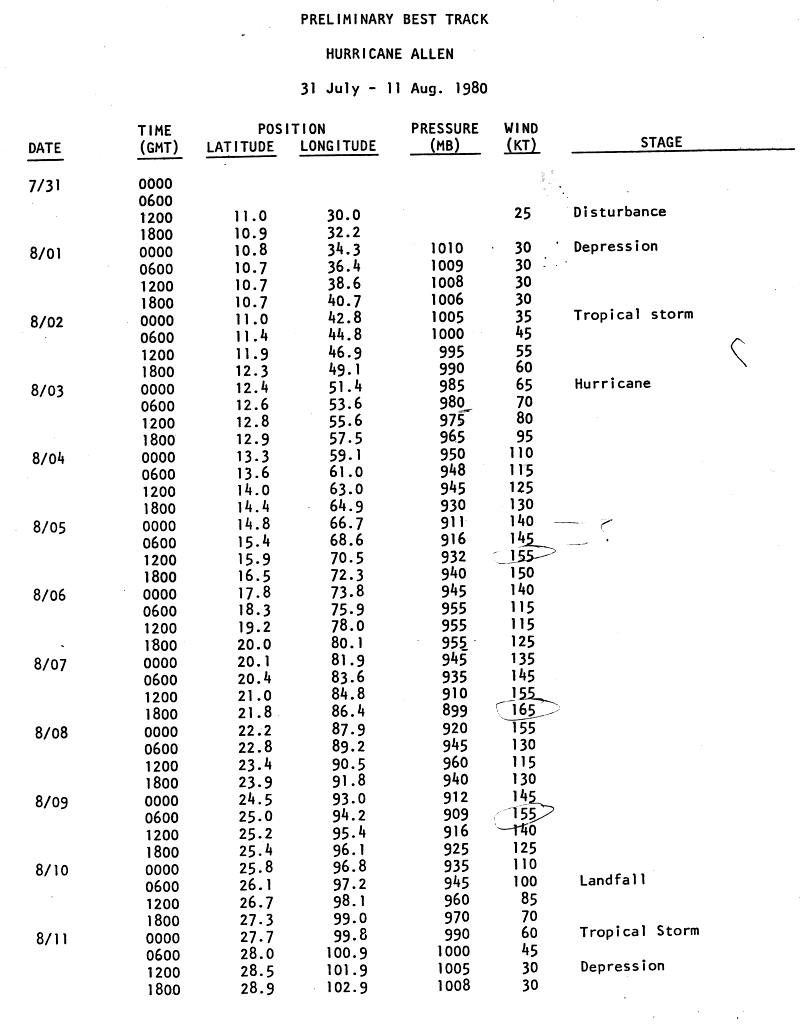
Dorian broke numerous intensity records after it reached its peak intensity. Dorian is tied with the 1935 Labor Day hurricane,Gilbert,Wilma and Melissa for the second-highest wind speed of an Atlantic hurricane at 185mph (295km/h),[42][43] just below Allen's record wind speed of 190mph (305km/h).[44] This intensity made Dorian the strongest hurricane outside of the tropics.[43] The cyclone's 185mph (295km/h) landfall on Abaco Island was the strongest on record for The Bahamas.[3][43] Dorian was the second Category5 hurricane to make landfall on the Abaco Islands on record,the other having occurred in 1932.[45] Additionally,Dorian is tied with the 1935 Labor Day hurricane for the highest sustained winds at landfall in an Atlantic hurricane.[46] With Dorian,2019 became the fourth consecutive year to produce at least one Category5 hurricane.[47][nb 4]
Dorian's slow forward motion near The Bahamas also set several records. During one 24-hour period,Dorian moved slower than any other major hurricane since Hurricane Betsy in 1965.[43] The storm also impacted a single land area as a Category5 hurricane for the longest duration recorded in the Atlantic basin,with portions of Dorian's eyewall striking Great Abaco Island and Grand Bahama for about 22hours.[48]
↑ The figures for maximum sustained winds and position estimates are rounded to the nearest 5units (knots, miles, or kilometers), following the convention used in the National Hurricane Center's products. Direct wind observations are rounded to the nearest whole number. All winds are one-minute sustained, unless otherwise noted. Atmospheric pressures are listed to the nearest millibar and nearest hundredth of an inch of mercury.
↑ Storms with designations in quotation marks are officially unnamed. Tropical storms and hurricanes were not named before the year 1950.[39]
↑ The four-year period of 2016–2019 broke the record for most consecutive years yielding at least one Category 5 storm.[47]
↑ Cangialosi, John; Latto, Andrew (August 30, 2019). Hurricane Dorian Tropical Cyclone Update (Report). National Hurricane Center. Archived from the original on September 1, 2019. Retrieved September 3, 2019.
↑ Avila, Lixion (September 1, 2019). Hurricane Dorian Discussion Number 33 (Report). National Hurricane Center. Archived from the original on September 7, 2019. Retrieved September 4, 2019.
↑ Brown, Daniel (September 3, 2019). Hurricane Dorian Discussion Number 41 (Report). National Hurricane Center. Archived from the original on September 5, 2019. Retrieved September 5, 2019.
↑ Brown, Daniel (September 3, 2019). Hurricane Dorian Discussion Number 42 (Report). National Hurricane Center. Archived from the original on September 3, 2019. Retrieved September 5, 2019.
↑ Pasch, Richard (September 4, 2019). Hurricane Dorian Discussion Number 44 (Report). National Hurricane Center. Archived from the original on September 4, 2019. Retrieved September 5, 2019.
↑ Avila, Lixion (September 5, 2019). Hurricane Dorian Discussion Number 47 (Report). National Hurricane Center. Archived from the original on September 5, 2019. Retrieved September 6, 2019.
↑ Cangialosi, John (September 6, 2019). Hurricane Dorian Discussion Number 52 (Report). National Hurricane Center. Archived from the original on September 6, 2019. Retrieved September 6, 2019.
↑ Avila, Lixion (September 7, 2019). Hurricane Dorian Discussion Number 55 (Report). National Hurricane Center. Archived from the original on September 13, 2019. Retrieved September 7, 2019.
↑ Cangialosi, John (September 7, 2019). Hurricane Dorian Discussion Number 56 (Report). National Hurricane Center. Archived from the original on July 21, 2020. Retrieved September 7, 2019.
↑ Franklin, James (January 31, 2008). Hurricane Dean(PDF) (Report). National Hurricane Center. Retrieved November 19, 2025.
↑ Landsea, Chris; Hagen, Andrew; Bredemeyer, William; Carrasco, Cristina; Glenn, David; Santiago, Adrian; Strahan-Sakoskie, Donna; Dickinson, Michael (August 15, 2014). A Reanalysis of the 1931–43 Atlantic Hurricane Database(PDF) (Report). American Meteorological Society, Journal of Climate. p.6114. Archived from the original(PDF) on May 4, 2017.
This page is based on this Wikipedia article Text is available under the CC BY-SA 4.0 license; additional terms may apply. Images, videos and audio are available under their respective licenses.


