| Mount Bagot | |
|---|---|
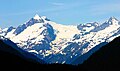
| Boundary Peak 107 | |
 Southwest aspect | |
| Highest point | |
| Elevation | 2,181 m (7,156 ft) [1] |
| Prominence | 801 m (2,628 ft) [1] |
| Isolation | 6.51 km (4.05 mi) [1] |
| Coordinates | 59°20′54″N135°01′29″W / 59.34833°N 135.02472°W [2] |
| Naming | |
| Etymology | Charles Bagot |
| Geography | |
 Mount Bagot Location in Alaska  Mount Bagot Location in British Columbia | |
 | |
| Interactive map of Mount Bagot | |
| Countries | |
| Province | |
| State | Alaska |
| Parent range | Coast Mountains Boundary Ranges |
| Topo map(s) | NTS 104M6 Mount Bagot [2] USGS Skagway B-1 [3] |
| Climbing | |
| First ascent | 1967 |
Mount Bagot is a 2,181-metre (7,156-foot) mountain summit located on, and in part defining, the international border between British Columbia, Canada, and Alaska, United States.