Municipal District of Foothills No. 31

Last updated
Municipal District of Foothills No. 31
Municipal district
Foothills No 31, Alberta.svg
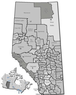
Alberta municipal districts.png
Red pog.svg
Location of Foothills No. 31 in Alberta
Coordinates: 50°34′51″N113°52′28″W / 50.58083°N 113.87444°W / 50.58083; -113.87444 Coordinates: 50°34′51″N113°52′28″W / 50.58083°N 113.87444°W / 50.58083; -113.87444
CountryFlag of Canada.svg  Canada
Province Flag of Alberta.svg  Alberta
Region Calgary Region
Census division No. 6
Established1944
Incorporated1944
Government
[1]
   Reeve vacant
  Governing body
  ManagerHarry Riva Cambrin
   Office location High River
Area
 (2016) [2]
  Land3,636.8 km2 (1,404.2 sq mi)
Population
(2016) [2]
  Total22,766
  Density6.3/km2 (16/sq mi)
Time zone UTC-7 (MST)
Website mdfoothills.com

The Municipal District of Foothills No. 31 is a municipal district in southern Alberta, Canada adjacent to the south side of Calgary in Census Division No. 6. Despite sharing a common border with the City of Calgary of more than 20 kilometers and enveloping an agglomerate population of more than 70,000 people it has never been considered a part of the Calgary Census Metropolitan Area (CMA) by Statistics Canada. However, with membership in a regional metropolitan economic association, this Municipal District and its enclosed towns are generally accepted as constituent population, social and economic components of the Greater Calgary area.

Alberta Province of Canada

Alberta is a western province of Canada. With an estimated population of 4,067,175 as of 2016 census, it is Canada's fourth most populous province and the most populous of Canada's three prairie provinces. Its area is about 660,000 square kilometres (250,000 sq mi). Alberta and its neighbour Saskatchewan were districts of the Northwest Territories until they were established as provinces on September 1, 1905. The premier has been Rachel Notley since 2015.

Canada Country in North America

Canada is a country in the northern part of North America. Its ten provinces and three territories extend from the Atlantic to the Pacific and northward into the Arctic Ocean, covering 9.98 million square kilometres, making it the world's second-largest country by total area. Canada's southern border with the United States, stretching some 8,891 kilometres (5,525 mi), is the world's longest bi-national land border. Its capital is Ottawa, and its three largest metropolitan areas are Toronto, Montreal, and Vancouver. As a whole, Canada is sparsely populated, the majority of its land area being dominated by forest and tundra. Consequently, its population is highly urbanized, with over 80 percent of its inhabitants concentrated in large and medium-sized cities, with 70% of citizens residing within 100 kilometres (62 mi) of the southern border. Canada's climate varies widely across its vast area, ranging from arctic weather in the north, to hot summers in the southern regions, with four distinct seasons.

Calgary City in Alberta, Canada

Calgary is a city in the Canadian province of Alberta. It is situated at the confluence of the Bow River and the Elbow River in the south of the province, in an area of foothills and prairie, about 80 km (50 mi) east of the front ranges of the Canadian Rockies. The city anchors the south end of what Statistics Canada defines as the "Calgary–Edmonton Corridor".

Contents

Demographics

In the 2016 Census of Population conducted by Statistics Canada, the Municipal District of Foothills No. 31 recorded a population of 22,766 living in 8,156 of its 8,689 total private dwellings, a 7.1% change from its 2011 population of 21,248. With a land area of 3,636.8 km2 (1,404.2 sq mi), it had a population density of 6.3/km2 (16.2/sq mi) in 2016. [2]

Statistics Canada, formed in 1971, is the Government of Canada government agency commissioned with producing statistics to help better understand Canada, its population, resources, economy, society, and culture. Its headquarters is in Ottawa. The Minister responsible for Statistics Canada is the Minister of Innovation, Science and Economic Development, currently Navdeep Bains.

In the 2011 Census, the Municipal District of Foothills No. 31 had a population of 21,258 living in 7,643 of its 8,401 total dwellings, a 7.7% change from its 2006 adjusted population of 19,731. With a land area of 3,642.9 km2 (1,406.5 sq mi), it had a population density of 5.8/km2 (15.1/sq mi) in 2011. [3] Following High River's 2012 annexation, Statistics Canada adjusted the M.D. of Foothills No. 31's 2011 population downward by 10 people to 21,248. [4]

Communities and localities

Attractions

See also

Related Research Articles

Division No. 6, Alberta Census division in Alberta in Canada

Division No. 6 is a census division in Alberta, Canada. Surrounding the City of Calgary, the majority of the division comprises Alberta's Calgary Region, while the northern portion of the division is located within central Alberta. The division also forms the southern segment of the Calgary–Edmonton Corridor. Division No. 6 is the largest census division in Alberta according to population and also has the highest population density.

Sundre Town in Alberta, Canada

Sundre is a town in central Alberta, Canada. It is located in Mountain View County, 100 km (62 mi) northwest from Calgary, along the Cowboy Trail in the Canadian Rockies foothills.

Irricana Town in Alberta, Canada

Irricana is a town in southern Alberta, Canada surrounded by Rocky View County. It is located adjacent to Highway 9, approximately 53 kilometres (33 mi) northeast of Calgary, west of the Drumheller badlands.

County of Grande Prairie No. 1 Municipal district in Alberta, Canada

The County of Grande Prairie No. 1 is a municipal district in northwestern Alberta, Canada in Census Division No. 19.

Donnelly, Alberta Village in Alberta, Canada

Donnelly is a village in northern Alberta, Canada within the Municipal District of Smoky River No. 130. It is located near the intersection of Highway 2 and Highway 49, located approximately 65 km (40 mi) south of Peace River and 427 km (265 mi) northwest of Edmonton.

Municipal District of Acadia No. 34 Municipal district in Alberta, Canada

The Municipal District (M.D.) of Acadia No. 34 is a municipal district in southern Alberta, Canada, east of Calgary, close to the Saskatchewan border, in Census Division No. 4.

Yellowhead County Municipal district in Alberta, Canada

Yellowhead County is a municipal district in west central Alberta, Canada.

Municipal District of Bighorn No. 8 Municipal district in Alberta, Canada

The Municipal District of Bighorn No. 8 is a municipal district situated in Census Division No. 15 of Alberta, Canada. It is located between Calgary and Banff National Park, north of Kananaskis Improvement District. Highway 1 bisects this county.

Cochrane Lake, Alberta

Cochrane Lake is a hamlet in southern Alberta under the jurisdiction of Rocky View County. Statistics Canada also recognizes a smaller portion of the hamlet as a designated place under the name of Cochrane Lake Subdivision.

Kneehill County Municipal district in Alberta, Canada

Kneehill County is a municipal district situated in Division No. 5, Alberta, central Alberta.

Beaver County, Alberta Municipal district in Alberta, Canada

Beaver County is a municipal district in central-east Alberta, Canada. It is centred on Holden in the western part of Census Division No. 10. Its municipal office is located in Ryley.

County of Forty Mile No. 8 Municipal district in Alberta, Canada

The County of Forty Mile No. 8 is a municipal district in south eastern Alberta, Canada.

Lacombe County Municipal district in Alberta, Canada

Lacombe County is a municipal district in central Alberta, Canada, located in Census Division No. 8 north of the City of Red Deer. Its municipal office is 4 km (2.5 mi) west of Highway 2 and the City of Lacombe, and 6 km (3.7 mi) east of the Summer Village of Gull Lake, at the intersection of Highway 12 and Spruceville Road.

Woodlands County Municipal district in Alberta, Canada

Woodlands County is a municipal district in north-central Alberta, Canada. Located in Census Division No. 13, its municipal office is located outside but adjacent to the Town of Whitecourt. A second municipal office is located in the Hamlet of Fort Assiniboine.

Mackenzie County Specialized municipality in Alberta, Canada

Mackenzie County is a specialized municipality in northern Alberta, Canada. It is located in Census Division 17, along the Mackenzie Highway. Incorporated as a municipal district in 1995 from the former Improvement District No. 23., its status was changed to specialized municipality in 1999 to address the particularities of managing such a large territory, which is 10% larger than New Brunswick. Mackenzie County municipal office is located in the Hamlet of Fort Vermilion. The name was changed from the Municipal District of Mackenzie No. 23 to Mackenzie County in 2007.

County of Northern Lights Municipal district in Alberta, Canada

The County of Northern Lights is a municipal district in northwest Alberta, Canada. Located in Census Division 17, its municipal office is located in the Town of Manning.

Wheatland County, Alberta Municipal district in Alberta, Canada

Wheatland County is a municipal district in south-central Alberta, Canada, east of Calgary. Located in Census Division No. 5, its municipal office is located east of the Town of Strathmore on Highway 1.

County of Wetaskiwin No. 10 Municipal district in Alberta, Canada

The County of Wetaskiwin No. 10 is a municipal district in central Alberta, Canada, south of Edmonton. Located in Census Division No. 11, its municipal office is in located in the City of Wetaskiwin.

Smoky Lake County Municipal district in Alberta, Canada

Smoky Lake County is a municipal district in north-eastern Alberta, Canada. Located in Census Division No. 12, its municipal office is located in the Town of Smoky Lake.

County of Paintearth No. 18 Municipal district in Alberta, Canada

The County of Paintearth No. 18 is a municipal district in east central Alberta, Canada. Located in Census Division No. 7, its municipal office is located southeast of the Town of Castor near the intersection of Highway 12 and Highway 36.

References

  1. "Municipal Officials Search". Alberta Municipal Affairs. September 22, 2017. Retrieved September 25, 2017.
  2. 1 2 3 "Population and dwelling counts, for Canada, provinces and territories, and census subdivisions (municipalities), 2016 and 2011 censuses – 100% data (Alberta)". Statistics Canada. February 8, 2017. Retrieved February 8, 2017.
  3. "Population and dwelling counts, for Canada, provinces and territories, and census subdivisions (municipalities), 2011 and 2006 censuses (Alberta)". Statistics Canada. February 8, 2012. Retrieved February 8, 2012.
  4. "Interim List of Changes to Municipal Boundaries, Status, and Names From January 2, 2011 to January 1, 2012 (Table 1 – Changes to census subdivisions in alphabetical order by province and territory)" (XLSX). Statistics Canada. November 14, 2012. Retrieved August 17, 2013.
  5. 1 2 "Specialized and Rural Municipalities and Their Communities" (PDF). Alberta Municipal Affairs. 2013-12-31. Retrieved 2015-01-20.
  6. "Standard Geographical Classification (SGC) 2006, Economic Regions: 4806001 - Foothills No. 31, geographical codes and localities, 2006". Statistics Canada. 2010-03-05. Retrieved 2012-08-11.