
The Great Dividing Range, also known as the East Australian Cordillera or the Eastern Highlands, is a cordillera system in eastern Australia consisting of an expansive collection of mountain ranges, plateaus and rolling hills, that runs roughly parallel to the east coast of Australia and forms the fifth-longest land-based mountain chain in the world, and the longest entirely within a single country. It is mainland Australia's most substantial topographic feature and serves as the definitive watershed for the river systems in eastern Australia, hence the name.

Murray Hill is a neighborhood on the east side of Manhattan in New York City. Murray Hill is generally bordered to the east by the East River or Kips Bay and to the west by Midtown Manhattan, though the exact boundaries are disputed. Murray Hill is situated on a steep glacial hill that peaked between Lexington Avenue and Broadway. It was named after Robert Murray, the head of the Murray family, a mercantile family that settled in the area in the 18th century.

Mount Majura is a small mountain with an elevation of 890 metres (2,920 ft) AHD that is located in the northern suburbs of Canberra in the Australian Capital Territory, Australia. Mount Majura lies close to the more prominent Mount Ainslie and is the highest point within the urban boundaries of Canberra. Mount Majura is contained within part of the Canberra Nature Park.

The Illawarra escarpment, or officially the Illawarra Range, is the fold-created cliffs and plateau-eroded outcrop mountain range west of the Illawarra coastal plain south of Sydney, in the state of New South Wales, Australia. The range encloses the Illawarra region which stretches from Stanwell Park in the north to Kiama, Gerringong and the Shoalhaven River in the south.

Sikinos is a Greek island and municipality in the Cyclades. It is located midway between the islands of Ios and Folegandros. Sikinos is part of the Thira regional unit.

Northern Alberta is a geographic region located in the Canadian province of Alberta.

Vly Mountain is a mountain located in the town of Halcott, New York, United States in Greene County. The mountain is part of the Catskill Mountains. Vly Mountain is flanked to the northwest by Bearpen Mountain, to the east by Vinegar Hill, to the northeast by Kipp Hill, and to the southeast by Beech Ridge.
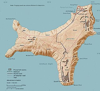
Murray Hill is the highest point of Christmas Island, at 357 metres (1,171 ft) above sea level. It was first scaled in 1857 even though the island had been located in 1615.
The Goorudee Rivulet, a perennial river of the Murrumbidgee catchment of the Murray-Darling basin, is located in the Snowy Mountains region of New South Wales, Australia.
Daedala or Daidala was a city of the Rhodian Peraea in ancient Caria, or a small place, as Stephanus of Byzantium says, on the authority of Strabo.

The Little Murray River, an anabranch of the Murray River and part of the Murray–Darling basin, is located in the Mallee district of north western Victoria, in eastern Australia.

Paddys River, a watercourse of the Murray catchment within the Murray–Darling basin, is located in the Australian Alpine region of New South Wales, Australia.
Tumbarumba Creek, a watercourse of the Murray catchment within the Murray–Darling basin, is located in the region bordering the Riverina and Australian Alps of New South Wales, Australia.

The Cooma Creek, a mostly–perennial river that is part of the Murrumbidgee catchment within the Murray–Darling basin, is located in the Monaro region of New South Wales, Australia.
The Cooma Back Creek, a mostly–perennial river that is part of the Murrumbidgee catchment within the Murray–Darling basin, is located in the Monaro region of New South Wales, Australia.
The Jerra Jerra Creek, a perennial stream of the Murray River catchment within the Murray-Darling basin, is located in the Riverina region of New South Wales, Australia.
In South Australia, one of the states of Australia, there are many areas which are commonly known by regional names. Regions are areas that share similar characteristics. These characteristics may be natural such as the Murray River, the coastline, desert or mountains. Alternatively, the characteristics may be cultural, such as common land use. South Australia is divided by numerous sets of regional boundaries, based on different characteristics. In many cases boundaries defined by different agencies are coterminous.

Rum Hill is a mountain located in Central New York Region of New York northwest of the Hamlet of Pierstown. Red House Hill is located southeast, Metcalf Hill is located south, Allen Lake and Mohegan Hill are located north-northwest and Otsego Lake is located east of Rum Hill.

Red Hill is a mountain located in the Catskill Mountains of New York east-south of Frost Valley. Woodhull Mountain is located northeast of Red Hill.
Mount Don Bosco is a mountain located in the Catskill Mountains of New York southeast of Ellenville. Shawangunk Ridge is located south, High Point is located northeast, Murray Hill is located east-northeast, Losees Hill is located south, and Mount Meenahga is located northwest of Mount Don Bosco.

