National Register of Historic Places listings in Roosevelt County, New Mexico

Last updated
Location of Roosevelt County in New Mexico Map of New Mexico highlighting Roosevelt County.svg
Location of Roosevelt County in New Mexico

This is a list of the National Register of Historic Places listings in Roosevelt County, New Mexico.

Contents

This is intended to be a complete list of the properties and districts on the National Register of Historic Places in Roosevelt County, New Mexico, United States. Latitude and longitude coordinates are provided for many National Register properties and districts; these locations may be seen together in a map. [1]

National Register of Historic Places federal list of historic sites in the United States

The National Register of Historic Places (NRHP) is the United States federal government's official list of districts, sites, buildings, structures, and objects deemed worthy of preservation for their historical significance. A property listed in the National Register, or located within a National Register Historic District, may qualify for tax incentives derived from the total value of expenses incurred preserving the property.

Roosevelt County, New Mexico County in the United States

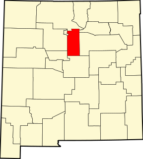
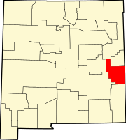
Roosevelt County is a county located in the U.S. state of New Mexico. As of the 2010 census, the population was 19,846. Its county seat is Portales. The county was created in 1903 from Chaves and Guadalupe counties and named for President Theodore Roosevelt. The county's eastern border is the Texas state line.

New Mexico State of the United States of America

New Mexico is a state in the Southwestern region of the United States of America; its capital and cultural center is Santa Fe, which was founded in 1610 as capital of Nuevo México, while its largest city is Albuquerque with its accompanying metropolitan area. It is one of the Mountain States and shares the Four Corners region with Utah, Colorado, and Arizona; its other neighboring states are Oklahoma to the northeast, Texas to the east-southeast, and the Mexican states of Chihuahua to the south and Sonora to the southwest. With a population around two million, New Mexico is the 36th state by population. With a total area of 121,592 sq mi (314,920 km2), it is the fifth-largest and sixth-least densely populated of the 50 states. Due to their geographic locations, northern and eastern New Mexico exhibit a colder, alpine climate, while western and southern New Mexico exhibit a warmer, arid climate.

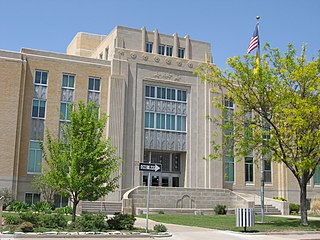
There are 7 properties listed on the National Register in the county, including 1 National Historic Landmark.

National Historic Landmark formal designation assigned by the United States federal government to historic buildings and sites in the United States

A National Historic Landmark (NHL) is a building, district, object, site, or structure that is officially recognized by the United States government for its outstanding historical significance. Of over 90,000 places listed on the country's National Register of Historic Places, only some 2,500 are recognized as National Historic Landmarks.

This National Park Service list is complete through NPS recent listings posted February 15, 2019. [2]
Map all coordinates using: OpenStreetMap  
Download coordinates as: KML  ·  GPX
Contents: Counties in New Mexico
Bernalillo  Catron  Chaves  Cibola  Colfax  Curry  De Baca  Doña Ana  Eddy  Grant  Guadalupe  Harding  Hidalgo  Lea  Lincoln  Los Alamos  Luna  McKinley  Mora  Otero  Quay  Rio Arriba  Roosevelt  San Juan  San Miguel  Sandoval  Santa Fe  Sierra  Socorro  Taos  Torrance  Union  Valencia

Current listings

[3] Name on the Register [4] ImageDate listed [5] Location City or townDescription
1 Administration Building
Administration Building ENMU Administration Building, S side 1.JPG
Administration Building
September 22, 1988
(#88001558)
Southern side of University Pl. and campus green, Eastern New Mexico University
34°10′44″N103°20′53″W / 34.179012°N 103.348044°W / 34.179012; -103.348044 (Administration Building)
Portales New Mexico State Register of Cultural Properties (SRCP)
2 Anderson Basin
Anderson Basin Blackwater Draw archaeological site, entrance from E 1.JPG
Anderson Basin
October 15, 1966
(#66000483)
New Mexico Highway 467, about 5 miles north of U.S. Highway 70 [6]
34°16′35″N103°19′11″W / 34.276337°N 103.319735°W / 34.276337; -103.319735 (Anderson Basin)
Clovis
3 Bank of Portales
Bank of Portales Bank of Portales building from SSW 1.JPG
Bank of Portales
December 27, 1984
(#84000635)
Near First and Main [7]
34°11′13″N103°20′15″W / 34.187016°N 103.337409°W / 34.187016; -103.337409 (Bank of Portales)
Portales SRCP
4 Davis Mercantile December 14, 2018
(#100003218)
4610 NM 206
33°38′34″N103°20′24″W / 33.6429°N 103.3400°W / 33.6429; -103.3400 (Davis Mercantile)
Milnesand
5 Midway Service Station
Midway Service Station Kenna Store from W 3.JPG
Midway Service Station
January 12, 2005
(#04001479)
38797 U.S. Highway 70
33°50′31″N103°46′20″W / 33.841990°N 103.772221°W / 33.841990; -103.772221 (Midway Service Station)
Kenna SRCP
6 Roosevelt County Courthouse
Roosevelt County Courthouse Roosevelt County Court House.jpg
Roosevelt County Courthouse
December 3, 2008
(#08001136)
100 W. 2nd St.
34°11′09″N103°20′11″W / 34.18592°N 103.3365°W / 34.18592; -103.3365 (Roosevelt County Courthouse)
Portales SRCP
7 US Post Office-Portales Main
US Post Office-Portales Main Portales, New Mexico, post office from SE 1.JPG
US Post Office-Portales Main
February 23, 1990
(#90000140)
116 W. 1st St.
34°11′11″N103°20′17″W / 34.186356°N 103.338118°W / 34.186356; -103.338118 (US Post Office-Portales Main)
Portales

See also

National Register of Historic Places listings in New Mexico Wikimedia list article

This is a list of properties and districts in New Mexico that are on the National Register of Historic Places. There are more than 1,100 listings. Of these, 46 are National Historic Landmarks. There are listings in each of the state's 33 counties.

Related Research Articles

National Register of Historic Places listings in Essex County, Massachusetts Wikimedia list article

This list is of that portion of the National Register of Historic Places (NRHP) designated in Essex County, Massachusetts. The locations of these properties and districts for which the latitude and longitude coordinates are included below, may be seen in a map.

National Register of Historic Places listings in Dauphin County, Pennsylvania Wikimedia list article

This is a list of the National Register of Historic Places listings in Dauphin County, Pennsylvania.

National Register of Historic Places listings in San Bernardino County, California Wikimedia list article

This is a list of the National Register of Historic Places listings in San Bernardino County, California.

National Register of Historic Places listings in Centre County, Pennsylvania Wikimedia list article

This is a list of the National Register of Historic Places listings in Centre County, Pennsylvania.

National Register of Historic Places listings in Santa Fe County, New Mexico Wikimedia list article

This is a list of the National Register of Historic Places listings in Santa Fe County, New Mexico.

National Register of Historic Places listings in Rio Arriba County, New Mexico Wikimedia list article

This is a list of the National Register of Historic Places listings in Rio Arriba County, New Mexico.

National Register of Historic Places listings in McKinley County, New Mexico Wikimedia list article

This is a list of the National Register of Historic Places listings in McKinley County, New Mexico.

National Register of Historic Places listings in Tooele County, Utah Wikimedia list article

This is a list of the National Register of Historic Places listings in Tooele County, Utah.

National Register of Historic Places listings in Uintah County, Utah Wikimedia list article

This is a list of the National Register of Historic Places listings in Uintah County, Utah.

National Register of Historic Places listings in Utah County, Utah Wikimedia list article

This is a list of the National Register of Historic Places listings in Utah County, Utah.

National Register of Historic Places listings in Clark County, Idaho Wikimedia list article

This is a list of the National Register of Historic Places listings in Clark County, Idaho.

National Register of Historic Places listings in Porter County, Indiana Wikimedia list article

This is a list of the National Register of Historic Places listings in Porter County, Indiana.

National Register of Historic Places listings in Colfax County, New Mexico Wikimedia list article

This is a list of the National Register of Historic Places listings in Colfax County, New Mexico.

National Register of Historic Places listings in Doña Ana County, New Mexico Wikimedia list article

This is a list of the National Register of Historic Places listings in Doña Ana County, New Mexico.

National Register of Historic Places listings in Lincoln County, New Mexico Wikimedia list article

This is a list of the National Register of Historic Places listings in Lincoln County, New Mexico.

National Register of Historic Places listings in Mora County, New Mexico Wikimedia list article

This is a list of the National Register of Historic Places listings in Mora County, New Mexico.

National Register of Historic Places listings in Gratiot County, Michigan Wikimedia list article

This is a list of the National Register of Historic Places listings in Gratiot County, Michigan.

National Register of Historic Places listings in Los Alamos County, New Mexico Wikimedia list article

This is a list of the National Register of Historic Places listings in Los Alamos County, New Mexico.

National Register of Historic Places listings in Union County, New Mexico

This is a list of the National Register of Historic Places listings in Union County, New Mexico.

National Register of Historic Places listings in Morris County, Texas Wikimedia list article

This is a list of the National Register of Historic Places listings in Morris County, Texas.

References

  1. The latitude and longitude information provided in this table was derived originally from the National Register Information System, which has been found to be fairly accurate for about 99% of listings. For about 1% of NRIS original coordinates, experience has shown that one or both coordinates are typos or otherwise extremely far off; some corrections may have been made. A more subtle problem causes many locations to be off by up to 150 yards, depending on location in the country: most NRIS coordinates were derived from tracing out latitude and longitudes from USGS topographical quadrant maps created under the North American Datum of 1927 , which differs from the current, highly accurate WGS84 GPS system used by most on-line maps. Chicago is about right, but NRIS longitudes in Washington are higher by about 4.5 seconds, and are lower by about 2.0 seconds in Maine. Latitudes differ by about 1.0 second in Florida. Some locations in this table may have been corrected to current GPS standards.
  2. "National Register of Historic Places: Weekly List Actions". National Park Service, United States Department of the Interior. Retrieved on February 15, 2019.
  3. Numbers represent an ordering by significant words. Various colorings, defined here, differentiate National Historic Landmarks and historic districts from other NRHP buildings, structures, sites or objects.
  4. National Park Service (2010-07-09). "National Register Information System". National Register of Historic Places . National Park Service.
  5. The eight-digit number below each date is the number assigned to each location in the National Register Information System database, which can be viewed by clicking the number.
  6. Location and provided coordinates are those of the "Blackwater Clovis Site", according to "Clovis Site", Eastern New Mexico University; the NRIS lists the site as "Address Restricted"
  7. See photo of intersection of First and Main. A cafe, Do Drop In, is located at 123 S. Main; see Roosevelt County Chamber website. The NRHP nominating form for the Bank of Portales gives "123 Main", which is either incomplete or incorrect.