National Register of Historic Places listings in McKinley County, New Mexico

Last updated

Location of McKinley County in New Mexico Map of New Mexico highlighting McKinley County.svg
Location of McKinley County in New Mexico

This is a list of the National Register of Historic Places listings in McKinley County, New Mexico.

Contents

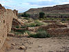
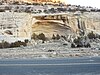
This is intended to be a complete list of the properties and districts on the National Register of Historic Places in McKinley County, New Mexico, United States. Latitude and longitude coordinates are provided for many National Register properties and districts; these locations may be seen together in a map. [1]

There are 77 properties and districts listed on the National Register in the county, including 2 National Historic Landmarks. Another two properties were once listed, but have since been removed. All of the places within the county currently or formerly on the National Register are also recorded on the State Register of Cultural Properties.


    This National Park Service list is complete through NPS recent listings posted December 8, 2023. [2]

Map all coordinates using: OpenStreetMap
Contents: NRHP in New Mexico by county
Bernalillo  Catron  Chaves  Cibola  Colfax  Curry  De Baca  Doña Ana  Eddy  Grant  Guadalupe  Harding  Hidalgo  Lea  Lincoln  Los Alamos  Luna  McKinley  Mora  Otero  Quay  Rio Arriba  Roosevelt  San Juan  San Miguel  Sandoval  Santa Fe  Sierra  Socorro  Taos  Torrance  Union  Valencia

Current listings

[3] Name on the Register [4] ImageDate listed [5] Location City or townDescription
1 Andrews Archeological District
Andrews Archeological District Address restricted.PNG
Andrews Archeological District
May 17, 1979
(#79003129)
Address Restricted
Prewitt
2 Archeological Site LA 15278 (Reservoir Site; CM 100)
Archeological Site LA 15278 (Reservoir Site; CM 100) Address restricted.PNG
Archeological Site LA 15278 (Reservoir Site; CM 100)
August 2, 1985
(#85001700)
Address Restricted
Pueblo Pintado
3 Archeological Site LA 45,780
Archeological Site LA 45,780 Address restricted.PNG
Archeological Site LA 45,780
August 2, 1985
(#85001701)
Address Restricted
Pueblo Pintado
4 Archeological Site LA 45,781
Archeological Site LA 45,781 Address restricted.PNG
Archeological Site LA 45,781
August 2, 1985
(#85001702)
Address Restricted
Pueblo Pintado
5 Archeological Site LA 45,782
Archeological Site LA 45,782 Address restricted.PNG
Archeological Site LA 45,782
August 2, 1985
(#85001703)
Address Restricted
Pueblo Pintado
6 Archeological Site LA 45,784
Archeological Site LA 45,784 Address restricted.PNG
Archeological Site LA 45,784
August 2, 1985
(#85001704)
Address Restricted
Pueblo Pintado
7 Archeological Site LA 45,785
Archeological Site LA 45,785 Address restricted.PNG
Archeological Site LA 45,785
August 2, 1985
(#85001705)
Address Restricted
Pueblo Pintado
8 Archeological Site LA 45,786
Archeological Site LA 45,786 Address restricted.PNG
Archeological Site LA 45,786
August 2, 1985
(#85001706)
Address Restricted
Pueblo Pintado
9 Archeological Site LA 45,789
Archeological Site LA 45,789 Address restricted.PNG
Archeological Site LA 45,789
August 2, 1985
(#85001707)
Address Restricted
Pueblo Pintado
10 Archeological Site LA 50,000
Archeological Site LA 50,000 Address restricted.PNG
Archeological Site LA 50,000
August 2, 1985
(#85001708)
Address Restricted
Pueblo Pintado
11 Archeological Site LA 50,001
Archeological Site LA 50,001 Address restricted.PNG
Archeological Site LA 50,001
August 2, 1985
(#85001709)
Address Restricted
Pueblo Pintado
12 Archeological Site LA 50,013 (CM101)
Archeological Site LA 50,013 (CM101) Address restricted.PNG
Archeological Site LA 50,013 (CM101)
August 2, 1985
(#85001710)
Address Restricted
Pueblo Pintado
13 Archeological Site LA 50,014 (CM 102)
Archeological Site LA 50,014 (CM 102) Address restricted.PNG
Archeological Site LA 50,014 (CM 102)
August 2, 1985
(#85001711)
Address Restricted
Pueblo Pintado
14 Archeological Site LA 50,015 (CM 102A)
Archeological Site LA 50,015 (CM 102A) Address restricted.PNG
Archeological Site LA 50,015 (CM 102A)
August 2, 1985
(#85001712)
Address Restricted
Pueblo Pintado
15 Archeological Site LA 50,016 (CM 103)
Archeological Site LA 50,016 (CM 103) Address restricted.PNG
Archeological Site LA 50,016 (CM 103)
August 2, 1985
(#85001713)
Address Restricted
Pueblo Pintado
16 Archeological Site LA 50,017 (CM 104)
Archeological Site LA 50,017 (CM 104) Address restricted.PNG
Archeological Site LA 50,017 (CM 104)
August 2, 1985
(#85001714)
Address Restricted
Pueblo Pintado
17 Archeological Site LA 50,018
Archeological Site LA 50,018 Address restricted.PNG
Archeological Site LA 50,018
August 2, 1985
(#85001715)
Address Restricted
Pueblo Pintado
18 Archeological Site LA 50,019 (CM 105)
Archeological Site LA 50,019 (CM 105) Address restricted.PNG
Archeological Site LA 50,019 (CM 105)
August 2, 1985
(#85001716)
Address Restricted
Pueblo Pintado
19 Archeological Site LA 50,020 (CM 106)
Archeological Site LA 50,020 (CM 106) Address restricted.PNG
Archeological Site LA 50,020 (CM 106)
August 2, 1985
(#85001717)
Address Restricted
Pueblo Pintado
20 Archeological Site LA 50,021
Archeological Site LA 50,021 Address restricted.PNG
Archeological Site LA 50,021
August 2, 1985
(#85001718)
Address Restricted
Pueblo Pintado
21 Archeological Site LA 50,022 (CM 107)
Archeological Site LA 50,022 (CM 107) Address restricted.PNG
Archeological Site LA 50,022 (CM 107)
August 2, 1985
(#85001719)
Address Restricted
Pueblo Pintado
22 Archeological Site LA 50,023 (CM 118)
Archeological Site LA 50,023 (CM 118) Address restricted.PNG
Archeological Site LA 50,023 (CM 118)
August 2, 1985
(#85001720)
Address Restricted
Pueblo Pintado
23 Archeological Site LA 50,024 (CM 108)
Archeological Site LA 50,024 (CM 108) Address restricted.PNG
Archeological Site LA 50,024 (CM 108)
August 2, 1985
(#85001721)
Address Restricted
Pueblo Pintado
24 Archeological Site LA 50,025 (CM 109)
Archeological Site LA 50,025 (CM 109) Address restricted.PNG
Archeological Site LA 50,025 (CM 109)
August 2, 1985
(#85001722)
Address Restricted
Pueblo Pintado
25 Archeological Site LA 50,026 (CM 108)
Archeological Site LA 50,026 (CM 108) Address restricted.PNG
Archeological Site LA 50,026 (CM 108)
August 2, 1985
(#85001723)
Address Restricted
Pueblo Pintado
26 Archeological Site LA 50,027 (CM 111)
Archeological Site LA 50,027 (CM 111) Address restricted.PNG
Archeological Site LA 50,027 (CM 111)
August 2, 1985
(#85001724)
Address Restricted
Pueblo Pintado
27 Archeological Site LA 50,028 (CM 112)
Archeological Site LA 50,028 (CM 112) Address restricted.PNG
Archeological Site LA 50,028 (CM 112)
August 2, 1985
(#85001725)
Address Restricted
Pueblo Pintado
28 Archeological Site LA 50,030 (CM 114)
Archeological Site LA 50,030 (CM 114) Address restricted.PNG
Archeological Site LA 50,030 (CM 114)
August 2, 1985
(#85001726)
Address Restricted
Pueblo Pintado
29 Archeological Site LA 50,031 (CM 115)
Archeological Site LA 50,031 (CM 115) Address restricted.PNG
Archeological Site LA 50,031 (CM 115)
August 2, 1985
(#85001727)
Address Restricted
Pueblo Pintado
30 Archeological Site LA 50,033 (CM 117)
Archeological Site LA 50,033 (CM 117) Address restricted.PNG
Archeological Site LA 50,033 (CM 117)
August 2, 1985
(#85001728)
Address Restricted
Pueblo Pintado
31 Archeological Site LA 50,034
Archeological Site LA 50,034 Address restricted.PNG
Archeological Site LA 50,034
August 2, 1985
(#85001729)
Address Restricted
Pueblo Pintado
32 Archeological Site LA 50,035
Archeological Site LA 50,035 Address restricted.PNG
Archeological Site LA 50,035
October 9, 1985
(#85003143)
Address Restricted
Pueblo Pintado
33 Archeological Site LA 50,036
Archeological Site LA 50,036 Address restricted.PNG
Archeological Site LA 50,036
August 2, 1985
(#85001730)
Address Restricted
Pueblo Pintado
34 Archeological Site LA 50,037
Archeological Site LA 50,037 Address restricted.PNG
Archeological Site LA 50,037
August 2, 1985
(#85001731)
Address Restricted
Pueblo Pintado
35 Archeological Site LA 50,038
Archeological Site LA 50,038 Address restricted.PNG
Archeological Site LA 50,038
August 2, 1985
(#85001732)
Address Restricted
Pueblo Pintado
36 Archeological Site LA 50,044
Archeological Site LA 50,044 Address restricted.PNG
Archeological Site LA 50,044
August 2, 1985
(#85001733)
Address Restricted
Pueblo Pintado
37 Archeological Site LA 50,071 (CM 148)
Archeological Site LA 50,071 (CM 148) Address restricted.PNG
Archeological Site LA 50,071 (CM 148)
August 2, 1985
(#85001734)
Address Restricted
Pueblo Pintado
38 Archeological Site LA 50,072 (CM 94)
Archeological Site LA 50,072 (CM 94) Address restricted.PNG
Archeological Site LA 50,072 (CM 94)
August 2, 1985
(#85001735)
Address Restricted
Pueblo Pintado
39 Archeological Site LA 50,074 (CM 181)
Archeological Site LA 50,074 (CM 181) Address restricted.PNG
Archeological Site LA 50,074 (CM 181)
August 2, 1985
(#85001736)
Address Restricted
Pueblo Pintado
40 Archeological Site LA 50,077
Archeological Site LA 50,077 Address restricted.PNG
Archeological Site LA 50,077
August 2, 1985
(#85001737)
Address Restricted
Pueblo Pintado
41 Archeological Site LA 50,080
Archeological Site LA 50,080 Address restricted.PNG
Archeological Site LA 50,080
August 2, 1985
(#85001738)
Address Restricted
Pueblo Pintado
42 Ashcroft-Merrill Historic District
Ashcroft-Merrill Historic District Josiah Emer Ashcroft House.jpg
Ashcroft-Merrill Historic District
July 27, 1990
(#90001079)
Junction of Bloomfield and McNeil Sts.
35°08′09″N108°29′41″W / 35.135833°N 108.494722°W / 35.135833; -108.494722 (Ashcroft-Merrill Historic District)
Ramah
43 Bee Burrow Archeological District
Bee Burrow Archeological District Bee Burrow Archeological District.jpg
Bee Burrow Archeological District
December 10, 1984
(#84001296)
Along Seven Lakes Wash north of Seven Lakes [6]
35°48′45″N107°57′02″W / 35.81238°N 107.95059°W / 35.81238; -107.95059 (Bee Burrow Archeological District)
Seven Lakes
44 Borrego Pass Trading Post Historic District March 29, 2012
(#11000475)
Building 1601, County Road 19
35°39′26″N108°06′20″W / 35.6572962°N 108.1054688°W / 35.6572962; -108.1054688 (Borrego Pass Trading Post Historic District)
Borrego Pass
45 Casa de Estrella Archeological Site
Casa de Estrella Archeological Site Address restricted.PNG
Casa de Estrella Archeological Site
October 10, 1980
(#80002553)
Address Restricted
Crownpoint
46 Chaco Culture National Historical Park
Chaco Culture National Historical Park CasaRinconada.jpg
Chaco Culture National Historical Park
October 15, 1966
(#66000895)
Address Restricted
Thoreau
47 Chief Theater May 16, 1988
(#87002223)
228 W. Coal Ave.
35°31′37″N108°44′37″W / 35.526944°N 108.743611°W / 35.526944; -108.743611 (Chief Theater)
Gallup "Pueblo Deco"-style theater built in 1920
48 C.N. Cotton Warehouse January 14, 1988
(#87002226)
101 N. Third St.
35°31′40″N108°44′41″W / 35.527778°N 108.744722°W / 35.527778; -108.744722 (C.N. Cotton Warehouse)
Gallup
49 Cousins Bros. Trading Post March 22, 2006
(#06000153)
768 A-D Cousins Rd.
35°15′04″N108°53′42″W / 35.251111°N 108.895°W / 35.251111; -108.895 (Cousins Bros. Trading Post)
Chi Chil Tah
50 Dalton Pass Archeological Site
Dalton Pass Archeological Site Address restricted.PNG
Dalton Pass Archeological Site
October 10, 1980
(#80002554)
Address Restricted
Crownpoint
51 Drake Hotel
Drake Hotel Drake Hotel 09-13-12.jpg
Drake Hotel
January 14, 1988
(#87002218)
216 E. 66th Ave.
35°31′43″N108°44′19″W / 35.528611°N 108.738611°W / 35.528611; -108.738611 (Drake Hotel)
Gallup
52 El Morro Theater
El Morro Theater El Morro Theater in Gallup..jpg
El Morro Theater
May 16, 1988
(#87002221)
205-209 W. Coal Ave.
35°33′14″N108°44′28″W / 35.553889°N 108.741111°W / 35.553889; -108.741111 (El Morro Theater)
Gallup
53 El Rancho Hotel
El Rancho Hotel Nocturnal Hotel El Rancho.jpg
El Rancho Hotel
January 14, 1988
(#87002222)
100 E. 66th Ave.
35°31′46″N108°43′18″W / 35.529444°N 108.721667°W / 35.529444; -108.721667 (El Rancho Hotel)
Gallup
54 Fort Wingate Archeological Site
Fort Wingate Archeological Site Address restricted.PNG
Fort Wingate Archeological Site
October 10, 1980
(#80002558)
Address Restricted
Fort Wingate
55 Fort Wingate Historic District
Fort Wingate Historic District (144)Fort Wingate, New Mexico (shows the fort and houses) - NARA - 517785.tif
Fort Wingate Historic District
May 26, 1978
(#78003076)
State Road 400
35°28′01″N108°32′23″W / 35.466944°N 108.539722°W / 35.466944; -108.539722 (Fort Wingate Historic District)
Fort Wingate
56 Gallup Commercial Historic District
Gallup Commercial Historic District Gallup NM - Downtown Coal Street.jpg
Gallup Commercial Historic District
June 21, 2016
(#16000389)
Roughly bounded by US 66, W. Coal Ave., S. Puerco Dr. and S. 7th St.
35°31′37″N108°44′42″W / 35.526864°N 108.744934°W / 35.526864; -108.744934 (Gallup Commercial Historic District)
Gallup
57 Grand Hotel
Grand Hotel The former Grand Hotel missing the luster it once held..jpg
Grand Hotel
May 25, 1988
(#87002217)
306 W. Coal Ave.
35°31′36″N108°44′38″W / 35.526667°N 108.743889°W / 35.526667; -108.743889 (Grand Hotel)
Gallup
58 Greenlee Archeological Site
Greenlee Archeological Site Address restricted.PNG
Greenlee Archeological Site
October 10, 1980
(#80002555)
Address Restricted
Crownpoint
59 Halona Pueblo February 10, 1975
(#75002066)
Zuni
35°04′04″N108°49′37″W / 35.067778°N 108.826944°W / 35.067778; -108.826944 (Halona Pueblo)
Gallup
60 Harvey Hotel May 25, 1988
(#87002219)
408 W. Coal Ave.
35°31′35″N108°44′42″W / 35.526389°N 108.745°W / 35.526389; -108.745 (Harvey Hotel)
Gallup
61 Haystack Archeological District
Haystack Archeological District Address restricted.PNG
Haystack Archeological District
October 10, 1980
(#80002556)
Address Restricted
Crownpoint
62 Roy T. Herman's Garage and Service Station
Roy T. Herman's Garage and Service Station Herman's.jpg
Roy T. Herman's Garage and Service Station
November 22, 1993
(#93001212)
State Road 122, 150 yards west of an exit from Interstate 40
35°23′50″N108°13′27″W / 35.397222°N 108.224167°W / 35.397222; -108.224167 (Roy T. Herman's Garage and Service Station)
Thoreau
63 Lebanon Lodge No. 22
Lebanon Lodge No. 22 Former Lebanon Lodge No. 22, now the Stronghold Church..jpg
Lebanon Lodge No. 22
February 14, 1989
(#87002225)
106 W. Aztec
35°31′36″N108°44′26″W / 35.526667°N 108.740556°W / 35.526667; -108.740556 (Lebanon Lodge No. 22)
Gallup
64 Manuelito Complex
Manuelito Complex New Mexico-Manuelito Canyon.jpg
Manuelito Complex
October 15, 1966
(#66000894)
Address Restricted
Manuelito
65 McKinley County Courthouse
McKinley County Courthouse McKinley County New Mexico Court House.jpg
McKinley County Courthouse
February 15, 1989
(#87000879)
205-209 W. Hill St.
35°31′29″N108°44′30″W / 35.524722°N 108.741667°W / 35.524722; -108.741667 (McKinley County Courthouse)
Gallup
66 Palace Hotel May 16, 1988
(#87002216)
236 W. 66th Ave.
35°31′39″N108°44′36″W / 35.5275°N 108.743333°W / 35.5275; -108.743333 (Palace Hotel)
Gallup
67 Peggy's Pueblo
Peggy's Pueblo Address restricted.PNG
Peggy's Pueblo
August 16, 1994
(#94000993)
Address Restricted
Zuni Pueblo
68 Redwood Lodge
Redwood Lodge REDWOOD LODGE-1.jpg
Redwood Lodge
February 13, 1998
(#98000051)
907 E. 66th Ave.
35°31′50″N108°43′46″W / 35.530556°N 108.729444°W / 35.530556; -108.729444 (Redwood Lodge)
Gallup
69 Rex Hotel
Rex Hotel REX MUSEUM.jpg
Rex Hotel
January 14, 1988
(#87002215)
300 W. 66th Ave.
35°31′38″N108°44′37″W / 35.527222°N 108.743611°W / 35.527222; -108.743611 (Rex Hotel)
Gallup
70 Southwestern Range and Sheep Breeding Laboratory Historic District May 30, 2003
(#03000488)
Fort Wingate Work Center in the Cibola National Forest
35°27′17″N108°34′08″W / 35.454722°N 108.568889°W / 35.454722; -108.568889 (Southwestern Range and Sheep Breeding Laboratory Historic District)
Fort Wingate
71 Route 66, State maintained from Iyanbito to Rehobeth November 19, 1997
(#97001397)
Former U.S. Route 66 from Iyanbito Interchange at Interstate 40 to State Police Station Rehobeth
35°31′04″N108°34′46″W / 35.517778°N 108.579444°W / 35.517778; -108.579444 (Route 66, State maintained from Iyanbito to Rehobeth)
Rehobeth
72 Route 66, State Maintained from Manuelito to the Arizona Border
Route 66, State Maintained from Manuelito to the Arizona Border Route 66, Manuelito to Arizona.jpg
Route 66, State Maintained from Manuelito to the Arizona Border
November 22, 1993
(#93001209)
Western side of the Manuelito grade separation southwest to the Arizona border
35°24′40″N108°59′57″W / 35.411111°N 108.999167°W / 35.411111; -108.999167 (Route 66, State Maintained from Manuelito to the Arizona Border)
Mentmore
73 Upper Kin Klizhin Archeological Site
Upper Kin Klizhin Archeological Site Upper Kin Klizhin Archeological Site.jpg
Upper Kin Klizhin Archeological Site
October 10, 1980
(#80002557)
Along Kin Klizhin Wash south of Chaco Canyon, north of Crownpoint [7]
Coordinates missing
Crownpoint
74 US Post Office
US Post Office The former post office building, now the Comcast building in Gallup..jpg
US Post Office
May 25, 1988
(#87002228)
201 S. 1st St.
35°31′39″N108°44′25″W / 35.5275°N 108.740278°W / 35.5275; -108.740278 (US Post Office)
Gallup
75 Evon Zartman Vogt Ranch House February 4, 1993
(#92001819)
1 mile south of Ramah, 500 feet east of State Road 53
35°07′15″N108°29′00″W / 35.120833°N 108.483333°W / 35.120833; -108.483333 (Evon Zartman Vogt Ranch House)
Ramah
76 White Cafe
White Cafe WHITES CAFE-1.jpg
White Cafe
January 14, 1988
(#87002212)
100 W. 66th Ave.
35°31′41″N108°44′27″W / 35.528056°N 108.740833°W / 35.528056; -108.740833 (White Cafe)
Gallup
77 Zuni-Cibola Complex
Zuni-Cibola Complex Address restricted.PNG
Zuni-Cibola Complex
December 2, 1974
(#74002267)
Address Restricted
Zuni Pueblo Extends into Cibola and Valencia counties

Former listings

[3] Name on the RegisterImageDate listedDate removedLocationCity or townDescription
1 C.N. Cotton House July 10, 1979
(#79003128)
August 22, 1984406 W. Aztec Ave.
Gallup Destroyed by fire in May, 1984.
2 Log Cabin Motel November 22, 1993
(#93001213)
August 22, 20071010 West 66 Avenue
Gallup Destroyed by fire on April 13, 2004. [8]

See also

Related Research Articles

<span class="mw-page-title-main">National Register of Historic Places listings in Charlevoix County, Michigan</span>

This is a list of the National Register of Historic Places listings in Charlevoix County, Michigan.

<span class="mw-page-title-main">National Register of Historic Places listings in Fayette County, Pennsylvania</span>

This is a list of the National Register of Historic Places listings in Fayette County, Pennsylvania.

<span class="mw-page-title-main">National Register of Historic Places listings in Cuyahoga County, Ohio</span>

This is a list of the National Register of Historic Places listings in Cuyahoga County, Ohio.

<span class="mw-page-title-main">National Register of Historic Places listings in Hamilton County, Ohio</span>

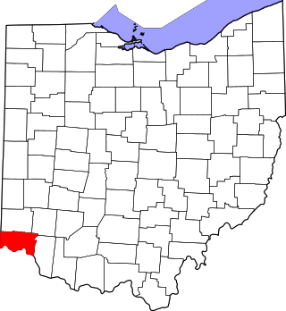
This is a list of the National Register of Historic Places listings in Hamilton County, Ohio.

<span class="mw-page-title-main">National Register of Historic Places listings in Dauphin County, Pennsylvania</span>

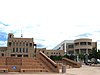
This is a list of the National Register of Historic Places listings in Dauphin County, Pennsylvania.

<span class="mw-page-title-main">National Register of Historic Places listings in Alachua County, Florida</span>

This is a list of the National Register of Historic Places listings in Alachua County, Florida.

<span class="mw-page-title-main">National Register of Historic Places listings in Delaware County, Ohio</span>

This is a list of the National Register of Historic Places listings in Delaware County, Ohio.

<span class="mw-page-title-main">National Register of Historic Places listings in Warren County, Ohio</span>

This is a list of the National Register of Historic Places listings in Warren County, Ohio.

<span class="mw-page-title-main">National Register of Historic Places listings in Ross County, Ohio</span>

This is a list of the National Register of Historic Places listings in Ross County, Ohio.

<span class="mw-page-title-main">National Register of Historic Places listings in Clermont County, Ohio</span>

This is a list of the National Register of Historic Places listings in Clermont County, Ohio.

<span class="mw-page-title-main">National Register of Historic Places listings in Adams County, Ohio</span>

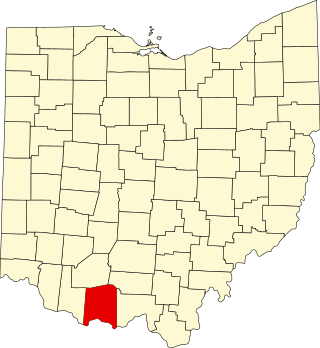
This is a list of the National Register of Historic Places listings in Adams County, Ohio.

<span class="mw-page-title-main">National Register of Historic Places listings in Santa Fe County, New Mexico</span>

This is a list of the National Register of Historic Places listings in Santa Fe County, New Mexico.

<span class="mw-page-title-main">National Register of Historic Places listings in Sandoval County, New Mexico</span>

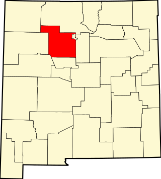
This is a list of the National Register of Historic Places listings in Sandoval County, New Mexico, United States.

<span class="mw-page-title-main">National Register of Historic Places listings in Rio Arriba County, New Mexico</span>

This is a list of the National Register of Historic Places listings in Rio Arriba County, New Mexico.

<span class="mw-page-title-main">National Register of Historic Places listings in San Juan County, New Mexico</span>

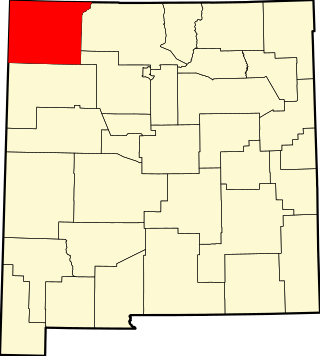
This is a list of the National Register of Historic Places listings in San Juan County, New Mexico.

<span class="mw-page-title-main">National Register of Historic Places listings in Gibson County, Indiana</span>

This is a list of the National Register of Historic Places listings in Gibson County, Indiana.

<span class="mw-page-title-main">National Register of Historic Places listings in Henry County, Indiana</span>

This is a list of the National Register of Historic Places listings in Henry County, Indiana.

<span class="mw-page-title-main">National Register of Historic Places listings in Posey County, Indiana</span>

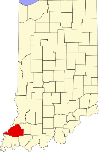
This is a list of the National Register of Historic Places listings in Posey County, Indiana.

<span class="mw-page-title-main">National Register of Historic Places listings in Monroe County, Ohio</span>

This is a list of the National Register of Historic Places listings in Monroe County, Ohio.

<span class="mw-page-title-main">National Register of Historic Places listings in Los Alamos County, New Mexico</span>

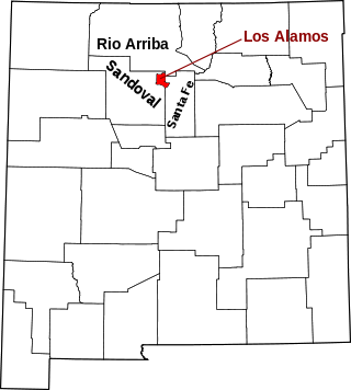
This is a list of the National Register of Historic Places listings in Los Alamos County, New Mexico.

References

  1. The latitude and longitude information provided in this table was derived originally from the National Register Information System, which has been found to be fairly accurate for about 99% of listings. Some locations in this table may have been corrected to current GPS standards.
  2. National Park Service, United States Department of the Interior, "National Register of Historic Places: Weekly List Actions", retrieved December 8, 2023.
  3. 1 2 Numbers represent an alphabetical ordering by significant words. Various colorings, defined here, differentiate National Historic Landmarks and historic districts from other NRHP buildings, structures, sites or objects.
  4. "National Register Information System". National Register of Historic Places . National Park Service. July 9, 2010.
  5. The eight-digit number below each date is the number assigned to each location in the National Register Information System database, which can be viewed by clicking the number.
  6. Location derived from its HABS entry and USGS maps described there; the NRIS lists it as "Address Restricted"
  7. Location derived from its HABS entry; the NRIS lists it as "Address Restricted"
  8. "Landmark lodge burns". Albuquerque Tribune . April 14, 2004. p. A2. Retrieved August 7, 2022 via Newspapers.com.