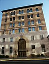
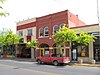
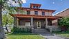
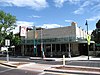
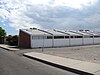
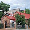
[4] Name on the Register [5] Image Date listed [6] Location City or town Description 1 Albuquerque Public Library Albuquerque Public Library August 19, 2024 (# 100010754 423 Central Avenue N.E. 35°05′02″N 106°38′33″W / 35.0839°N 106.6425°W / 35.0839; -106.6425 (Albuquerque Public Library ) Albuquerque The Old Main Library, built in 1925. 2 Albuquerque Veterans Administration Medical Center Albuquerque Veterans Administration Medical Center August 19, 1983 (# 83001614 2100 Ridgecrest, SE. 35°03′18″N 106°35′02″W / 35.055°N 106.583889°W / 35.055; -106.583889 (Albuquerque Veterans Administration Medical Center ) Albuquerque 3 Gavino Anaya House Gavino Anaya House February 9, 1984 (# 84002840 2939 Duranes Rd., NW. 35°06′32″N 106°40′57″W / 35.108889°N 106.6825°W / 35.108889; -106.6825 (Gavino Anaya House ) Albuquerque 4 Juan Cristobal Armijo Homestead Upload image September 30, 1982 (# 82003309 207 Griegos Rd., NE. 35°07′42″N 106°37′59″W / 35.128333°N 106.633056°W / 35.128333; -106.633056 (Juan Cristobal Armijo Homestead ) Albuquerque Hacienda hidden by shrubberies. 5 Salvador Armijo House Salvador Armijo House October 8, 1976 (# 76001191 618 Rio Grande Boulevard, NW. 35°05′58″N 106°40′10″W / 35.099444°N 106.669444°W / 35.099444; -106.669444 (Salvador Armijo House ) Albuquerque 6 Art Annex Art Annex September 22, 1988 (# 88001540 Northeastern corner of Central Ave. and Terrace St., University of New Mexico 35°04′53″N 106°37′27″W / 35.081389°N 106.624167°W / 35.081389; -106.624167 (Art Annex ) Albuquerque 7 AT & SF Freight Office AT & SF Freight Office December 24, 2013 (# 13000971 314 1st St. 35°04′54″N 106°38′54″W / 35.081612°N 106.648264°W / 35.081612; -106.648264 (AT & SF Freight Office ) Albuquerque Part of the Central Albuquerque MPS 8 Atchison, Topeka and Santa Fe Railway Locomotive Shops Atchison, Topeka and Santa Fe Railway Locomotive Shops October 15, 2014 (# 14000859 Roughly bounded by BNSF RR, 1st & 2nd Sts. 35°04′33″N 106°39′01″W / 35.0757°N 106.6502°W / 35.0757; -106.6502 (Atchison, Topeka and Santa Fe Railway Locomotive Shops ) Albuquerque 9 ATSF Locomotive No. 2926 ATSF Locomotive No. 2926 October 1, 2007 (# 07000388 1600 12th St., NW. 35°06′11″N 106°39′15″W / 35.103056°N 106.654167°W / 35.103056; -106.654167 (ATSF Locomotive No. 2926 ) Albuquerque 10 Aztec Auto Court Aztec Auto Court November 22, 1993 (# 93001217 3821 Central Ave., NE. 35°04′46″N 106°36′03″W / 35.079444°N 106.600833°W / 35.079444; -106.600833 (Aztec Auto Court ) Albuquerque Demolished in 2011 11 Adrian Barela House Adrian Barela House February 9, 1984 (# 84002843 7618 Guadalupe Trail, NW. 35°10′15″N 106°38′24″W / 35.17075°N 106.64°W / 35.17075; -106.64 (Adrian Barela House ) Los Ranchos de Albuquerque 12 Barela-Bledsoe House Barela-Bledsoe House March 12, 1979 (# 79001534 7017 Edith Boulevard, NE. 35°09′32″N 106°37′14″W / 35.158889°N 106.620556°W / 35.158889; -106.620556 (Barela-Bledsoe House ) Albuquerque 13 Barelas Community Center Barelas Community Center December 9, 2021 (# 100007239 801 Barelas Rd. SW 35°04′40″N 106°39′23″W / 35.0778°N 106.6564°W / 35.0778; -106.6564 (Barelas Community Center ) Albuquerque 14 Barelas-South Fourth Street Historic District Barelas-South Fourth Street Historic District July 24, 1997 (# 97000774 4th St. from Stover Ave. to Bridge St. 35°04′26″N 106°39′10″W / 35.073889°N 106.652778°W / 35.073889; -106.652778 (Barelas-South Fourth Street Historic District ) Albuquerque 15 Charles A. Bottger House Charles A. Bottger House March 7, 1983 (# 83001615 110 San Felipe, NW. 35°05′41″N 106°40′08″W / 35.094722°N 106.668889°W / 35.094722; -106.668889 (Charles A. Bottger House ) Albuquerque 16 Broadmoor Addition Upload image July 5, 2022 (# 100007699 Roughly bounded by Brockmont and Copper Aves, Morningside Dr., and Washington St. 35°04′58″N 106°35′50″W / 35.0829°N 106.5972°W / 35.0829; -106.5972 (Broadmoor Addition ) Albuquerque 17 Building at 701 Roma NW Building at 701 Roma NW February 28, 1985 (# 85000375 701 Roma, NW. 35°05′23″N 106°39′14″W / 35.089722°N 106.653889°W / 35.089722; -106.653889 (Building at 701 Roma NW ) Albuquerque 18 Carlisle Gymnasium Carlisle Gymnasium September 22, 1988 (# 88001541 University of New Mexico campus, west of Yale Boulevard 35°05′01″N 106°37′19″W / 35.083611°N 106.621944°W / 35.083611; -106.621944 (Carlisle Gymnasium ) Albuquerque 19 Chester Carnes House Chester Carnes House December 1, 1980 (# 80002529 701 13th St., NW. 35°05′38″N 106°39′36″W / 35.093889°N 106.66°W / 35.093889; -106.66 (Chester Carnes House ) Albuquerque 20 Castle Apartments Castle Apartments February 13, 1986 (# 86000219 1410 Central, SW. 35°05′17″N 106°39′50″W / 35.088056°N 106.663889°W / 35.088056; -106.663889 (Castle Apartments ) Albuquerque Demolished in 2010 after fire 21 Juan Chavez House Juan Chavez House February 9, 1984 (# 84002849 7809 4th St., NW. 35°09′46″N 106°38′04″W / 35.1628°N 106.6344°W / 35.1628; -106.6344 (Juan Chavez House ) Albuquerque 22 Juan de Dios Chavez House Juan de Dios Chavez House February 9, 1984 (# 84002847 205 Griegos Rd., NW. 35°07′42″N 106°37′58″W / 35.128333°N 106.632778°W / 35.128333; -106.632778 (Juan de Dios Chavez House ) Albuquerque 23 Rumaldo Chavez House Rumaldo Chavez House November 24, 1980 (# 80002530 10023 Edith Boulevard, NE. 35°11′35″N 106°36′11″W / 35.1931°N 106.6031°W / 35.1931; -106.6031 (Rumaldo Chavez House ) Alameda 24 Congregation B'nai Israel Congregation B'nai Israel May 2, 2019 (# 100003674 4401 Indian School Rd. 35°06′07″N 106°35′41″W / 35.1020°N 106.5946°W / 35.1020; -106.5946 (Congregation B'nai Israel ) Albuquerque 25 Coronado School Coronado School November 22, 1996 (# 96001383 601 4th St., SW. 35°04′44″N 106°39′08″W / 35.0789°N 106.6522°W / 35.0789; -106.6522 (Coronado School ) Albuquerque 26 Cottage Bakery Cottage Bakery November 22, 1993 (# 93001218 2000 Central Ave., SE. 35°04′51″N 106°37′25″W / 35.0808°N 106.6236°W / 35.0808; -106.6236 (Cottage Bakery ) Albuquerque 27 Davis House Davis House November 17, 1980 (# 80002531 704 Parkland Circle, SE. 35°04′11″N 106°36′10″W / 35.0697°N 106.6028°W / 35.0697; -106.6028 (Davis House ) Albuquerque 28 De Anza Motor Lodge De Anza Motor Lodge April 30, 2004 (# 04000375 4301 Central Ave., NE. 35°04′48″N 106°35′44″W / 35.08°N 106.5956°W / 35.08; -106.5956 (De Anza Motor Lodge ) Albuquerque Mostly demolished in 2018 29 Robert Dietz Farmhouse Robert Dietz Farmhouse February 9, 1984 (# 84002852 4117 Rio Grande Boulevard, NW. 35°08′23″N 106°40′04″W / 35.139722°N 106.667778°W / 35.139722; -106.667778 (Robert Dietz Farmhouse ) Albuquerque 30 Downtowner Motor Inn Downtowner Motor Inn November 4, 2020 (# 100005731 717 Central Ave. NW 35°05′07″N 106°39′22″W / 35.0852°N 106.6561°W / 35.0852; -106.6561 (Downtowner Motor Inn ) Albuquerque 31 Eighth Street-Forrester District Eighth Street-Forrester District December 1, 1980 (# 80002532 Roughly bounded by Mountain Rd., Lomas Boulevard, and Forrester and 7th Sts. 35°05′37″N 106°39′17″W / 35.0936°N 106.6547°W / 35.0936; -106.6547 (Eighth Street-Forrester District ) Albuquerque 32 El Campo Tourist Courts El Campo Tourist Courts January 13, 1994 (# 93001465 5800 Central Ave., SW. 35°04′52″N 106°42′10″W / 35.0811°N 106.7028°W / 35.0811; -106.7028 (El Campo Tourist Courts ) Albuquerque 33 El Vado Auto Court El Vado Auto Court November 22, 1993 (# 93001214 2500 Central Ave., SW. 35°05′39″N 106°40′36″W / 35.0942°N 106.6767°W / 35.0942; -106.6767 (El Vado Auto Court ) Albuquerque 34 Eller Apartments Eller Apartments January 12, 1984 (# 84002855 113-127 8th St., SW. 35°05′04″N 106°39′22″W / 35.084444°N 106.656111°W / 35.084444; -106.656111 (Eller Apartments ) Albuquerque 35 Employees' New Dormitory and Club Employees' New Dormitory and Club July 26, 1982 (# 82003310 Albuquerque Indian School campus 35°06′26″N 106°39′18″W / 35.1072°N 106.655°W / 35.1072; -106.655 (Employees' New Dormitory and Club ) Albuquerque 36 Enchanted Mesa Trading Post Enchanted Mesa Trading Post January 9, 1998 (# 97001595 9612 Central Ave., SE. 35°04′15″N 106°32′25″W / 35.0708°N 106.5403°W / 35.0708; -106.5403 (Enchanted Mesa Trading Post ) Albuquerque 37 Estufa Estufa September 22, 1988 (# 88001542 Southeastern corner of University Boulevard and Grand Ave., University of New Mexico 35°05′02″N 106°37′31″W / 35.0839°N 106.6253°W / 35.0839; -106.6253 (Estufa ) Albuquerque 38 Federal Building Federal Building November 22, 1980 (# 80002533 421 Gold Ave., SW. 35°05′02″N 106°39′08″W / 35.0839°N 106.6522°W / 35.0839; -106.6522 (Federal Building ) Albuquerque Built 1930. Federal Building and U.S. Courthouse, 500 Gold A venue, SW, Albuquerque, MP100009558, LISTED, 11/14/2023
39 Federal Building and U.S. Courthouse Federal Building and U.S. Courthouse November 14, 2023 (# 100009558 500 Gold Ave., SW. 35°05′01″N 106°39′12″W / 35.0835°N 106.6534°W / 35.0835; -106.6534 (Federal Building and U.S. Courthouse ) Albuquerque The Dennis Chavez Federal Building 40 First Methodist Episcopal Church First Methodist Episcopal Church November 7, 1976 (# 76001192 3rd St. and Lead Ave. 35°04′52″N 106°39′02″W / 35.0811°N 106.6506°W / 35.0811; -106.6506 (First Methodist Episcopal Church ) Albuquerque 41 First National Bank Building First National Bank Building February 2, 1979 (# 79003127 217-233 Central Ave., NW. 35°05′05″N 106°38′58″W / 35.0847°N 106.6494°W / 35.0847; -106.6494 (First National Bank Building ) Albuquerque 42 Five Points Community Church Upload image July 1, 2024 (# 100010498 1534 Bridge Boulevard SW 35°03′58″N 106°40′33″W / 35.0661°N 106.6758°W / 35.0661; -106.6758 (Five Points Community Church ) Albuquerque 43 C. M. Foraker Farmhouse Upload image February 9, 1984 (# 84002858 905 Menaul Boulevard, NW. 35°06′46″N 106°39′12″W / 35.1128°N 106.6533°W / 35.1128; -106.6533 (C. M. Foraker Farmhouse ) Albuquerque Burned down in 2008 44 Fourth Ward District Fourth Ward District December 1, 1980 (# 80002534 Roughly bounded by Central Ave., Lomas Boulevard, and 8th and 15th Sts. 35°05′26″N 106°39′27″W / 35.090556°N 106.6575°W / 35.090556; -106.6575 (Fourth Ward District ) Albuquerque 45 Juan Antonio Garcia House Juan Antonio Garcia House September 28, 1982 (# 82003311 7442 Edith Boulevard, NE. 35°09′48″N 106°37′05″W / 35.163333°N 106.618056°W / 35.163333; -106.618056 (Juan Antonio Garcia House ) Albuquerque 46 James N. Gladding House James N. Gladding House November 17, 1980 (# 80002535 643 Cedar St., NE. 35°05′17″N 106°37′50″W / 35.088056°N 106.630556°W / 35.088056; -106.630556 (James N. Gladding House ) Albuquerque 47 Refugio Gomez House Upload image February 9, 1984 (# 84002864 7604 Guadalupe Trail, NW. 35°10′13″N 106°38′24″W / 35.17032°N 106.64°W / 35.17032; -106.64 (Refugio Gomez House ) Los Ranchos de Albuquerque 48 Granada Heights Upload image July 5, 2022 (# 100007700 Roughly bounded by Silver and Garfield Aves., Carlisle Blvd., and Morningside Dr. 35°04′32″N 106°36′08″W / 35.0755°N 106.6023°W / 35.0755; -106.6023 (Granada Heights ) Albuquerque 49 Charles Grande House Charles Grande House February 9, 1984 (# 84002866 4317 Grande St., NW. 35°07′46″N 106°39′17″W / 35.129444°N 106.654722°W / 35.129444; -106.654722 (Charles Grande House ) Albuquerque 50 Tomasa Griego de Garcia House Upload image June 19, 1979 (# 79001535 6939 Edith Boulevard, NE. 35°09′29″N 106°37′18″W / 35.1581°N 106.6217°W / 35.1581; -106.6217 (Tomasa Griego de Garcia House ) Albuquerque 51 Delfina Gurule House Delfina Gurule House December 1, 1980 (# 80002536 306 16th St., NW. 35°05′32″N 106°39′48″W / 35.092222°N 106.663333°W / 35.092222; -106.663333 (Delfina Gurule House ) Albuquerque 52 Harwood School Harwood School December 1, 1980 (# 80002537 1114 7th St., NW. 35°05′42″N 106°39′10″W / 35.095°N 106.652778°W / 35.095; -106.652778 (Harwood School ) Albuquerque 53 A. W. Hayden House A. W. Hayden House December 1, 1980 (# 80002538 609 Marble St., NW. 35°05′37″N 106°39′07″W / 35.093611°N 106.651944°W / 35.093611; -106.651944 (A. W. Hayden House ) Albuquerque 54 Heights Community Center Heights Community Center December 9, 2021 (# 100007238 823 Buena Vista Ave. SE 35°04′24″N 106°37′27″W / 35.0734°N 106.6241°W / 35.0734; -106.6241 (Heights Community Center ) Albuquerque 55 Hendren Building Hendren Building January 27, 2000 (# 99001678 3001 Monte Vista Boulevard, NE. 35°05′00″N 106°36′43″W / 35.083333°N 106.611944°W / 35.083333; -106.611944 (Hendren Building ) Albuquerque 56 Hilltop Lodge Hilltop Lodge January 9, 1998 (# 97001597 5410 Central Ave. SW. 35°04′56″N 106°41′47″W / 35.082222°N 106.696389°W / 35.082222; -106.696389 (Hilltop Lodge ) Albuquerque Demolished in 2003 57 Hodgin Hall Hodgin Hall January 30, 1978 (# 78001803 University of New Mexico campus 35°04′54″N 106°37′29″W / 35.081667°N 106.624722°W / 35.081667; -106.624722 (Hodgin Hall ) Albuquerque 58 Hoffmantown Baptist Church Hoffmantown Baptist Church October 25, 2019 (# 100004492 2335 Wyoming Blvd. NE 35°06′39″N 106°33′04″W / 35.1108°N 106.5510°W / 35.1108; -106.5510 (Hoffmantown Baptist Church ) Albuquerque 59 Holy Child Church Holy Child Church March 8, 1978 (# 78001810 Off Interstate 40 35°04′47″N 106°23′23″W / 35.079722°N 106.389722°W / 35.079722; -106.389722 (Holy Child Church ) Tijeras 60 Hope Building Hope Building August 29, 1980 (# 80002539 220 Gold St., SW. 35°04′27″N 106°38′58″W / 35.074167°N 106.649444°W / 35.074167; -106.649444 (Hope Building ) Albuquerque 61 James Lawrence and Juliana Gutierrez y Chavez Hubbell House James Lawrence and Juliana Gutierrez y Chavez Hubbell House August 3, 2015 (# 15000491 6029 Isleta Blvd. SW. 34°59′21″N 106°41′45″W / 34.9892°N 106.6958°W / 34.9892; -106.6958 (James Lawrence and Juliana Gutierrez y Chavez Hubbell House ) Albuquerque 62 Hudson House Hudson House February 24, 1982 (# 82003313 817 Gold Ave., SW. 35°05′04″N 106°39′24″W / 35.084444°N 106.656667°W / 35.084444; -106.656667 (Hudson House ) Albuquerque 63 Huning Highlands Conoco Service Station Huning Highlands Conoco Service Station July 19, 2006 (# 06000633 601 Coal Ave., SE. 35°04′52″N 106°38′30″W / 35.081111°N 106.641667°W / 35.081111; -106.641667 (Huning Highlands Conoco Service Station ) Albuquerque 64 Huning Highlands Historic District Huning Highlands Historic District November 17, 1978 (# 78001804 Bounded by Grand Ave., Interstate 25 , Iron Ave., and the former Santa Fe railroad line 35°04′51″N 106°38′31″W / 35.080833°N 106.641944°W / 35.080833; -106.641944 (Huning Highlands Historic District ) Albuquerque 65 Immanuel Presbyterian Church Immanuel Presbyterian Church February 22, 2011 (# 11000032 114 Carlisle Boulevard SE 35°04′43″N 106°36′15″W / 35.078611°N 106.604167°W / 35.078611; -106.604167 (Immanuel Presbyterian Church ) Albuquerque Buildings Designed by John Gaw Meem MPS 66 Isleta Pueblo Isleta Pueblo September 5, 1975 (# 75001162 U.S. Route 85 34°54′31″N 106°41′30″W / 34.908611°N 106.691667°W / 34.908611; -106.691667 (Isleta Pueblo ) Isleta Pueblo 67 Jones Motor Company Jones Motor Company November 22, 1993 (# 93001219 3226 Central Ave., SE. 35°04′38″N 106°37′09″W / 35.077222°N 106.619167°W / 35.077222; -106.619167 (Jones Motor Company ) Albuquerque 68 Jonson Gallery and House Jonson Gallery and House February 22, 2002 (# 02000050 1909 Las Lomas Rd., NE. 35°05′13″N 106°37′15″W / 35.086944°N 106.620833°W / 35.086944; -106.620833 (Jonson Gallery and House ) Albuquerque 69 Kimo Theater Kimo Theater May 2, 1977 (# 77000920 421 Central Ave. 35°05′06″N 106°39′07″W / 35.085°N 106.651944°W / 35.085; -106.651944 (Kimo Theater ) Albuquerque 70 S. H. Kress Building S. H. Kress Building April 19, 1984 (# 84002871 414-416 Central Ave., SW. 35°05′04″N 106°39′07″W / 35.084444°N 106.651944°W / 35.084444; -106.651944 (S. H. Kress Building ) Albuquerque 71 Kromer House Kromer House October 4, 1982 (# 82001048 1024 El Pueblo Rd., NW. 35°10′44″N 106°38′27″W / 35.178889°N 106.640833°W / 35.178889; -106.640833 (Kromer House ) Los Ranchos de Albuquerque 72 La Glorieta House La Glorieta House August 19, 1983 (# 83001616 1801 Central Ave., NW. 35°05′34″N 106°39′56″W / 35.092778°N 106.665556°W / 35.092778; -106.665556 (La Glorieta House ) Albuquerque 73 La Mesa Motel Upload image November 22, 1993 (# 93001220 7407 Central Ave., NE. 35°04′32″N 106°33′51″W / 35.075556°N 106.564167°W / 35.075556; -106.564167 (La Mesa Motel ) Albuquerque Demolished in 2003 74 La Puerta Lodge La Puerta Lodge January 9, 1998 (# 97001596 9710 Central Ave., SE. 35°04′09″N 106°32′22″W / 35.069167°N 106.539444°W / 35.069167; -106.539444 (La Puerta Lodge ) Albuquerque 75 Las Imagines Archeological District-Albuquerque West Mesa Escarpment Upload image November 19, 1986 (# 86003142 Address Restricted Albuquerque 76 Charles LeFeber House Upload image December 1, 1980 (# 80002540 313 15th St. NW 35°05′28″N 106°39′49″W / 35.09119°N 106.66369°W / 35.09119; -106.66369 (Charles LeFeber House ) Albuquerque 77 Lembke House Lembke House November 25, 1980 (# 80002541 312 Laguna Blvd. SW 35°05′18″N 106°40′05″W / 35.08825°N 106.668°W / 35.08825; -106.668 (Lembke House ) Albuquerque 78 Aldo Leopold Neighborhood Historic District Aldo Leopold Neighborhood Historic District October 16, 2002 (# 02001164 105-135 14th St., SW. 35°05′15″N 106°39′45″W / 35.0875°N 106.6625°W / 35.0875; -106.6625 (Aldo Leopold Neighborhood Historic District ) Albuquerque 79 William J. Leverett House William J. Leverett House February 13, 1986 (# 86000221 301 Dartmouth, NE. 35°05′08″N 106°36′44″W / 35.085556°N 106.612222°W / 35.085556; -106.612222 (William J. Leverett House ) Albuquerque 80 Charles W. Lewis Building Charles W. Lewis Building July 3, 1979 (# 79001533 1405-1407 2nd St., SW. 35°04′18″N 106°39′05″W / 35.071667°N 106.651389°W / 35.071667; -106.651389 (Charles W. Lewis Building ) Albuquerque 81 Hilario Lopez House Hilario Lopez House December 1, 1980 (# 80002542 208 16th St., NW. 35°05′28″N 106°39′48″W / 35.091111°N 106.663333°W / 35.091111; -106.663333 (Hilario Lopez House ) Albuquerque 82 Los Candelarias Chapel-San Antonio Chapel Los Candelarias Chapel-San Antonio Chapel February 9, 1984 (# 84002844 1934 Candelaria Rd., NW. 35°07′17″N 106°40′00″W / 35.121389°N 106.666667°W / 35.121389; -106.666667 (Los Candelarias Chapel-San Antonio Chapel ) Albuquerque 83 Los Duranes Chapel Los Duranes Chapel February 9, 1984 (# 84002854 2601 Indian School Rd., NW. 35°06′39″N 106°40′28″W / 35.110833°N 106.674444°W / 35.110833; -106.674444 (Los Duranes Chapel ) Albuquerque 84 Los Griegos Historic District Los Griegos Historic District February 9, 1984 (# 84002874 Griegos Rd. and Rio Grande Boulevard 35°08′09″N 106°39′46″W / 35.135833°N 106.662778°W / 35.135833; -106.662778 (Los Griegos Historic District ) Albuquerque 85 Los Poblanos Historic District Los Poblanos Historic District May 27, 1982 (# 82003321 State Road 194 35°08′46″N 106°40′05″W / 35.146111°N 106.668056°W / 35.146111; -106.668056 (Los Poblanos Historic District ) Los Ranchos de Albuquerque 86 Los Tomases Chapel Los Tomases Chapel February 9, 1984 (# 84002876 3101 Los Tomases, NW. 35°06′56″N 106°38′55″W / 35.115556°N 106.648611°W / 35.115556; -106.648611 (Los Tomases Chapel ) Albuquerque 87 Francisco Lucero y Montoya House Upload image February 9, 1984 (# 84002880 9742 4th St., NW. 35°11′32″N 106°36′56″W / 35.192222°N 106.615556°W / 35.192222; -106.615556 (Francisco Lucero y Montoya House ) Alameda 88 Luna Lodge Luna Lodge June 11, 1998 (# 98000600 9119 Central Ave., NE. 35°04′25″N 106°32′43″W / 35.073611°N 106.545278°W / 35.073611; -106.545278 (Luna Lodge ) Albuquerque 89 La Luz del Oeste Upload image October 27, 2023 (# 100009493 Loop One NW 35°08′28″N 106°41′47″W / 35.1412°N 106.6964°W / 35.1412; -106.6964 (La Luz del Oeste ) Albuquerque 90 Main Library Main Library June 13, 2019 (# 100003217 501 Copper Ave. NW. 35°05′09″N 106°39′12″W / 35.0858°N 106.6532°W / 35.0858; -106.6532 (Main Library ) Albuquerque 91 Maisel's Indian Trading Post Maisel's Indian Trading Post November 22, 1993 (# 93001215 510 Central Ave., SW. 35°05′04″N 106°39′10″W / 35.084444°N 106.652778°W / 35.084444; -106.652778 (Maisel's Indian Trading Post ) Albuquerque 92 Henry Mann House Henry Mann House December 1, 1980 (# 80002543 723 14th St., NW. 35°05′44″N 106°39′38″W / 35.095556°N 106.660556°W / 35.095556; -106.660556 (Henry Mann House ) Albuquerque 93 Manzano Court Addition Historic District Manzano Court Addition Historic District October 14, 2004 (# 03001234 1000-1025 Manzano Court, NW. 35°05′43″N 106°39′29″W / 35.095278°N 106.658056°W / 35.095278; -106.658056 (Manzano Court Addition Historic District ) Albuquerque 94 McCanna-Hubbell Building McCanna-Hubbell Building May 13, 1982 (# 82003314 418-424 Central, SW. 35°05′04″N 106°39′07″W / 35.084444°N 106.651944°W / 35.084444; -106.651944 (McCanna-Hubbell Building ) Albuquerque 95 Medical Arts Historic District Medical Arts Historic District January 2, 2024 (# 100009505 711, 717, and 801 Encino Place NE and 1010 Las Lomas Boulevard NE 35°05′24″N 106°37′55″W / 35.0899°N 106.6319°W / 35.0899; -106.6319 (Medical Arts Historic District ) Albuquerque 96 Menaul School Historic District Menaul School Historic District February 14, 1983 (# 83001617 Roughly bounded by Broadway, Claremont, Edith, and Menaul Aves., and 301 Menaul Boulevard, NE. 35°06′44″N 106°38′14″W / 35.112222°N 106.637222°W / 35.112222; -106.637222 (Menaul School Historic District ) Albuquerque 97 John Milne House John Milne House February 13, 1986 (# 86000223 804 Park Ave., SW. 35°05′06″N 106°39′23″W / 35.085°N 106.656389°W / 35.085; -106.656389 (John Milne House ) Albuquerque 98 Modern Auto Court Modern Auto Court November 22, 1993 (# 93001221 3712 Central Ave., SE. 35°04′44″N 106°36′08″W / 35.078889°N 106.602222°W / 35.078889; -106.602222 (Modern Auto Court ) Albuquerque 99 Monte Vista and College View Historic District Monte Vista and College View Historic District August 3, 2001 (# 01000770 Roughly bounded by Girard and Lomas Boulevards, Morningside Dr., Copper Ave., and Campus and Monte Vista Boulevards. 35°05′02″N 106°36′23″W / 35.083889°N 106.606389°W / 35.083889; -106.606389 (Monte Vista and College View Historic District ) Albuquerque 100 Monte Vista Fire Station Monte Vista Fire Station March 19, 1987 (# 87001121 3201 Central Ave., NE. 35°04′51″N 106°36′31″W / 35.080833°N 106.608611°W / 35.080833; -106.608611 (Monte Vista Fire Station ) Albuquerque 101 Monte Vista School Monte Vista School August 12, 1981 (# 81000399 3211 Monte Vista Boulevard, NE. 35°04′58″N 106°36′35″W / 35.082778°N 106.609722°W / 35.082778; -106.609722 (Monte Vista School ) Albuquerque 102 National Humane Alliance Animal Fountain National Humane Alliance Animal Fountain September 30, 1986 (# 86003120 615 Virginia Ave., SE. 35°04′02″N 106°33′09″W / 35.067222°N 106.5525°W / 35.067222; -106.5525 (National Humane Alliance Animal Fountain ) Albuquerque 103 New Mexico Madonna of the Trail New Mexico Madonna of the Trail March 21, 2006 (# 06000151 Junction of Marble Ave. and 4th St. 35°05′41″N 106°38′59″W / 35.094722°N 106.649722°W / 35.094722; -106.649722 (New Mexico Madonna of the Trail ) Albuquerque 104 New Mexico-Arizona Wool Warehouse New Mexico-Arizona Wool Warehouse July 23, 1981 (# 81000400 520 1st St., NW. 35°05′19″N 106°38′48″W / 35.088611°N 106.646667°W / 35.088611; -106.646667 (New Mexico-Arizona Wool Warehouse ) Albuquerque 105 Newlander Apartments Newlander Apartments January 27, 2000 (# 99001677 616 Coal Ave. SW 35°04′58″N 106°39′20″W / 35.082778°N 106.655556°W / 35.082778; -106.655556 (Newlander Apartments ) Albuquerque 106 Nob Hill Business Center Nob Hill Business Center March 18, 1994 (# 84004143 3500 Central Ave., SE. 35°04′46″N 106°36′16″W / 35.079444°N 106.604444°W / 35.079444; -106.604444 (Nob Hill Business Center ) Albuquerque 107 Robert Nordhaus House Robert Nordhaus House February 9, 1984 (# 84002883 6900 Rio Grande Boulevard, NW. 35°09′47″N 106°39′00″W / 35.163056°N 106.65°W / 35.163056; -106.65 (Robert Nordhaus House ) Albuquerque 108 J. H. O'Rielly House J. H. O'Rielly House January 29, 1979 (# 79003442 220 9th St., NW. 35°05′13″N 106°39′23″W / 35.086944°N 106.656389°W / 35.086944; -106.656389 (J. H. O'Rielly House ) Albuquerque 109 Occidental Life Building Occidental Life Building January 30, 1978 (# 78001805 119 3rd Ave., SW. 35°05′01″N 106°39′01″W / 35.083611°N 106.650278°W / 35.083611; -106.650278 (Occidental Life Building ) Albuquerque 110 Old Albuquerque Municipal Airport Building Old Albuquerque Municipal Airport Building May 5, 1989 (# 89000348 2920 Yale Boulevard, SE. 35°02′52″N 106°37′14″W / 35.047778°N 106.620556°W / 35.047778; -106.620556 (Old Albuquerque Municipal Airport Building ) Albuquerque 111 Old Armijo School Old Armijo School September 16, 1982 (# 82003315 1021 Isleta Boulevard, SE. 35°03′22″N 106°40′11″W / 35.056111°N 106.669722°W / 35.056111; -106.669722 (Old Armijo School ) Albuquerque 112 Old Hilton Hotel Old Hilton Hotel March 2, 1984 (# 84002868 125 2nd St., NW. 35°05′06″N 106°38′56″W / 35.085°N 106.648889°W / 35.085; -106.648889 (Old Hilton Hotel ) Albuquerque 113 Old Post Office Old Post Office November 17, 1980 (# 80002544 123 4th St., SW. 35°05′01″N 106°39′08″W / 35.083611°N 106.652222°W / 35.083611; -106.652222 (Old Post Office ) Albuquerque 114 Our Lady of Mt. Carmel Church Our Lady of Mt. Carmel Church February 9, 1984 (# 84002884 7813 Edith Boulevard, NE. 35°10′08″N 106°37′03″W / 35.168889°N 106.6175°W / 35.168889; -106.6175 (Our Lady of Mt. Carmel Church ) Albuquerque 115 Our Lady of the Angels School Our Lady of the Angels School November 29, 1984 (# 84000426 320 Romero St., NW. 35°05′49″N 106°40′11″W / 35.096944°N 106.669722°W / 35.096944; -106.669722 (Our Lady of the Angels School ) Albuquerque 116 Pacific Desk Building Pacific Desk Building September 30, 1980 (# 80002545 213-215 Gold Ave., SW. 35°05′00″N 106°38′58″W / 35.083333°N 106.649444°W / 35.083333; -106.649444 (Pacific Desk Building ) Albuquerque 117 Parkland Hills Historic District Upload image June 7, 2019 (# 100004034 Roughly bounded by Zuni Rd., Garfield and Smith Aves, Valverde Dr., and Carlisle Blvd. 35°04′16″N 106°36′00″W / 35.0711°N 106.6001°W / 35.0711; -106.6001 (Parkland Hills Historic District ) Albuquerque 118 John Pearce House John Pearce House November 22, 1980 (# 80002546 718 Central Ave., SW. 35°05′05″N 106°39′18″W / 35.084722°N 106.655°W / 35.084722; -106.655 (John Pearce House ) Albuquerque 119 Petroglyph National Monument Petroglyph National Monument June 27, 1990 (# 01000279 6001 Unser Boulevard, NW. 35°09′46″N 106°43′18″W / 35.162778°N 106.721667°W / 35.162778; -106.721667 (Petroglyph National Monument ) Albuquerque 120 Piedras Marcadas Pueblo (LA 290) Upload image March 2, 1990 (# 90000160 Address Restricted Albuquerque 121 Pig 'n Calf Lunch Pig 'n Calf Lunch February 15, 1994 (# 93001222 2106 Central Ave., SE. 35°04′51″N 106°37′21″W / 35.080833°N 106.6225°W / 35.080833; -106.6225 (Pig 'n Calf Lunch ) Albuquerque 122 President's House President's House September 22, 1988 (# 88001543 Northeastern corner of Roma Ave. and Yale Boulevard, University of New Mexico 35°05′11″N 106°37′15″W / 35.086389°N 106.620833°W / 35.086389; -106.620833 (President's House ) Albuquerque Now called University House. 123 Ernie Pyle House Ernie Pyle House September 22, 1997 (# 97001103 900 Girard Boulevard, SE. 35°04′13″N 106°36′45″W / 35.070278°N 106.6125°W / 35.070278; -106.6125 (Ernie Pyle House ) Albuquerque 124 Rancho de Carnue Site Rancho de Carnue Site May 4, 1977 (# 77000921 Address Restricted Albuquerque 125 Sara Raynolds Hall Sara Raynolds Hall September 22, 1988 (# 88001544 University of New Mexico campus on Terrace St., north of Central Ave. 35°04′53″N 106°37′24″W / 35.081389°N 106.623333°W / 35.081389; -106.623333 (Sara Raynolds Hall ) Albuquerque 126 Rio Puerco Bridge Rio Puerco Bridge July 15, 1997 (# 97000735 Interstate 40 over the Rio Puerco 35°02′00″N 106°56′29″W / 35.033333°N 106.941389°W / 35.033333; -106.941389 (Rio Puerco Bridge ) Albuquerque 127 Felipe Romero House Felipe Romero House February 9, 1984 (# 84002885 7522 Edith Boulevard, NE. 35°09′55″N 106°37′03″W / 35.165278°N 106.6175°W / 35.165278; -106.6175 (Felipe Romero House ) Albuquerque 128 Roosevelt Park Roosevelt Park November 22, 1996 (# 96001384 Junction of Coal and Spruce Aves., SE. 35°04′35″N 106°37′49″W / 35.076389°N 106.630278°W / 35.076389; -106.630278 (Roosevelt Park ) Albuquerque 129 Rosenwald Building Rosenwald Building June 29, 1978 (# 78001806 320 Central Ave., SW. 35°05′03″N 106°39′03″W / 35.084167°N 106.650833°W / 35.084167; -106.650833 (Rosenwald Building ) Albuquerque 130 Route 66, State maintained from Albuquerque to Rio Puerco Route 66, State maintained from Albuquerque to Rio Puerco November 19, 1997 (# 97001396 Former U.S. Route 66 west central exit at Interstate 40 to the Rio Puerco bridge 35°02′55″N 106°52′04″W / 35.048611°N 106.867778°W / 35.048611; -106.867778 (Route 66, State maintained from Albuquerque to Rio Puerco ) Albuquerque 131 St. John's Cathedral St. John's Cathedral October 19, 2018 (# 100003029 318 Silver Ave. 35°04′56″N 106°39′06″W / 35.0823°N 106.6518°W / 35.0823; -106.6518 (St. John's Cathedral ) Albuquerque 132 Saint Joseph 1930 Hospital Saint Joseph 1930 Hospital May 27, 1982 (# 82003316 715 Grand, NE. 35°05′09″N 106°38′18″W / 35.085833°N 106.638333°W / 35.085833; -106.638333 (Saint Joseph 1930 Hospital ) Albuquerque 133 San Antonito Church and Cemetery San Antonito Church and Cemetery January 16, 1997 (# 96001607 Northwestern corner of the junction of State Roads 14 and 536 35°09′50″N 106°20′46″W / 35.163889°N 106.346111°W / 35.163889; -106.346111 (San Antonito Church and Cemetery ) San Antonito 134 San Felipe de Neri Church San Felipe de Neri Church October 1, 1969 (# 69000140 Old Town Plaza, NW. 35°05′47″N 106°40′09″W / 35.096389°N 106.669167°W / 35.096389; -106.669167 (San Felipe de Neri Church ) Albuquerque 135 San Ignacio Church San Ignacio Church August 21, 1979 (# 79001536 1300 Walter St., NE. 35°05′43″N 106°38′15″W / 35.095278°N 106.6375°W / 35.095278; -106.6375 (San Ignacio Church ) Albuquerque 136 Santa Barbara School Santa Barbara School September 28, 1989 (# 89001590 1420 Edith Boulevard, NE. 35°05′51″N 106°38′17″W / 35.0975°N 106.638056°W / 35.0975; -106.638056 (Santa Barbara School ) Albuquerque 137 Scholes Hall Scholes Hall September 22, 1988 (# 88001545 University of New Mexico campus, south of Roma Ave. 35°05′08″N 106°37′23″W / 35.085556°N 106.623056°W / 35.085556; -106.623056 (Scholes Hall ) Albuquerque 138 Second United Presbyterian Church Second United Presbyterian Church December 6, 1984 (# 84000563 812 Edith Boulevard, NE. 35°05′26″N 106°38′21″W / 35.090556°N 106.639167°W / 35.090556; -106.639167 (Second United Presbyterian Church ) Albuquerque 139 Samuel Shalit House Upload image February 9, 1984 (# 84002888 5209 4th St., NW. 35°08′06″N 106°38′30″W / 35.135°N 106.641667°W / 35.135; -106.641667 (Samuel Shalit House ) Albuquerque 140 Shoup Boarding House Upload image February 17, 1983 (# 83001618 707 1st St., SW. 35°04′40″N 106°38′56″W / 35.077778°N 106.648889°W / 35.077778; -106.648889 (Shoup Boarding House ) Albuquerque Demolished 141 Silver Hill Historic District Silver Hill Historic District September 18, 1986 (# 86002414 Roughly bounded by Central Ave., Yale Boulevard, Lead Ave., and Sycamore St. 35°04′46″N 106°37′33″W / 35.079444°N 106.625833°W / 35.079444; -106.625833 (Silver Hill Historic District ) Albuquerque 142 Simms Building Simms Building February 2, 1998 (# 97001653 400 Gold Ave., SW. 35°05′00″N 106°39′06″W / 35.083333°N 106.651667°W / 35.083333; -106.651667 (Simms Building ) Albuquerque 143 Skinner Building Skinner Building November 22, 1980 (# 80004485 722-724 Central Ave. and 108 8th St., SW. 35°05′06″N 106°39′20″W / 35.085°N 106.655556°W / 35.085; -106.655556 (Skinner Building ) Albuquerque 144 Solar Building Solar Building October 10, 1989 (# 89001589 213 Truman St., NE. 35°04′51″N 106°35′13″W / 35.080833°N 106.586944°W / 35.080833; -106.586944 (Solar Building ) Albuquerque 145 Southern Union Gas Company Building Southern Union Gas Company Building March 31, 2004 (# 04000252 723 Silver Ave., SW. 35°05′06″N 106°39′23″W / 35.085°N 106.656389°W / 35.085; -106.656389 (Southern Union Gas Company Building ) Albuquerque 146 Southwestern Brewery and Ice Company Southwestern Brewery and Ice Company March 30, 1978 (# 78001807 601 Commercial St., NE. 35°05′20″N 106°38′42″W / 35.088889°N 106.645°W / 35.088889; -106.645 (Southwestern Brewery and Ice Company ) Albuquerque 147 Berthold Spitz House Berthold Spitz House December 22, 1977 (# 77000922 323 N. 10th St. 35°05′19″N 106°39′28″W / 35.088611°N 106.657778°W / 35.088611; -106.657778 (Berthold Spitz House ) Albuquerque 148 Springer Building Springer Building November 18, 1980 (# 80002547 121 Tijeras Ave., NE. 35°05′09″N 106°38′43″W / 35.085833°N 106.645278°W / 35.085833; -106.645278 (Springer Building ) Albuquerque 149 Spruce Park Historic District Spruce Park Historic District July 6, 1982 (# 82003317 Roughly bounded by University Boulevard, Grand Ave., Las Lomas Rd., and Cedar St. 35°05′13″N 106°37′48″W / 35.086944°N 106.63°W / 35.086944; -106.63 (Spruce Park Historic District ) Albuquerque 150 Superintendent's House, Atlantic & Pacific Railroad Superintendent's House, Atlantic & Pacific Railroad January 20, 1978 (# 78001808 1023 2nd St. SW 35°04′29″N 106°39′03″W / 35.074722°N 106.650833°W / 35.074722; -106.650833 (Superintendent's House, Atlantic & Pacific Railroad ) Albuquerque 151 Domingo Tafoya House Upload image November 17, 1980 (# 80002528 10021 Edith Boulevard, NE. 35°11′35″N 106°36′12″W / 35.193056°N 106.603333°W / 35.193056; -106.603333 (Domingo Tafoya House ) Alameda 152 Tewa Lodge Tewa Lodge June 11, 1998 (# 98000599 5715 Central Ave. NE. 35°04′40″N 106°34′53″W / 35.077778°N 106.581389°W / 35.077778; -106.581389 (Tewa Lodge ) Albuquerque 153 Tijeras Pueblo Archeological Site Tijeras Pueblo Archeological Site November 17, 2005 (# 05001294 South of central Tijeras off State Road 337 35°04′30″N 106°23′00″W / 35.075°N 106.383333°W / 35.075; -106.383333 (Tijeras Pueblo Archeological Site ) Tijeras 154 Tower Court Tower Court November 22, 1993 (# 93001216 2210 Central Ave., SW. 35°05′42″N 106°40′26″W / 35.095°N 106.673889°W / 35.095; -106.673889 (Tower Court ) Albuquerque 155 Antonio Vigil House Antonio Vigil House May 5, 1978 (# 78001809 413 Romero St. 35°05′52″N 106°40′12″W / 35.097778°N 106.67°W / 35.097778; -106.67 (Antonio Vigil House ) Albuquerque 156 Vista Larga Residential Historic District Upload image April 12, 2016 (# 16000160 Roughly bounded by Indian School Rd., Columbia Dr., Hannett Ave., and University of New Mexico North Golf Course 35°06′02″N 106°37′09″W / 35.100421°N 106.619119°W / 35.100421; -106.619119 (Vista Larga Residential Historic District ) Albuquerque 157 Washington Apartments Washington Apartments February 19, 1982 (# 82003319 1002-1008 Central Ave., SW. 35°05′11″N 106°39′31″W / 35.086389°N 106.658611°W / 35.086389; -106.658611 (Washington Apartments ) Albuquerque 158 Werner-Gilchrist House Werner-Gilchrist House August 2, 1982 (# 82003320 202 Cornell, SE. 35°04′44″N 106°37′07″W / 35.078889°N 106.618611°W / 35.078889; -106.618611 (Werner-Gilchrist House ) Albuquerque Demolished in 2011 159 West San Jose School West San Jose School November 22, 1996 (# 96001385 1701 4th St., SW. 35°04′06″N 106°39′06″W / 35.068333°N 106.651667°W / 35.068333; -106.651667 (West San Jose School ) Albuquerque 160 Whitcomb Springs Upload image October 7, 2019 (# 100004498 82 Carlito Springs Rd. 35°05′15″N 106°24′01″W / 35.0876°N 106.4004°W / 35.0876; -106.4004 (Whitcomb Springs ) Tijeras 161 J. R. Willis House and La Miradora Apartments J. R. Willis House and La Miradora Apartments September 1, 2005 (# 05000942 310 Rio Grande Boulevard, SW. 35°05′36″N 106°40′16″W / 35.093333°N 106.671111°W / 35.093333; -106.671111 (J. R. Willis House and La Miradora Apartments ) Albuquerque 162 Charles Zeiger House Upload image April 27, 1984 (# 84002889 3200 Edith Boulevard, NE. 35°07′02″N 106°38′01″W / 35.117222°N 106.633611°W / 35.117222; -106.633611 (Charles Zeiger House ) Albuquerque Demolished 163 Zimmerman Library Zimmerman Library August 22, 2016 (# 16000549 1900 Roma Ave., NE. 35°05′09″N 106°37′17″W / 35.085878°N 106.621466°W / 35.085878; -106.621466 (Zimmerman Library ) Albuquerque