National Register of Historic Places listings in Trempealeau County, Wisconsin
Last updated
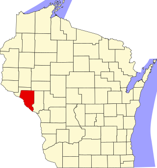
Location of Trempealeau County in Wisconsin
This is a list of the National Register of Historic Places listings in Trempealeau County, Wisconsin. It is intended to provide a comprehensive listing of entries in the National Register of Historic Places that are located in Trempealeau County, Wisconsin. The locations of National Register properties for which the latitude and longitude coordinates are included below may be seen in a map.[1]
The front brick blacksmith shop was built in 1871, one of the earliest commercial buildings in town. In 1900 it was converted to a boarding house called the Scandinavia Hotel. In 1945 it was converted again, to a dairy plant. Now a residence.[9]
Fine 2.5-story brick house with gabled-ell plan built in 1901.[10] John immigrated from Germany, farmed, served in the Civil War, and held stock in the Bank of Galesville.[11]
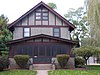
1908 house designed by G. H. Carsley in Tudor Revival style, with the original carriage house. President of the Bank of Galesville, Cance had worked his way up from an entry-level position.[12][13]
17 contributing buildings, mostly commercial, including the 1871 Bartlett Blacksmith shop, the 1886 Romanesque Revival Clark Block, the 1902 Romanesque Revival T. E. Jensen & Co Confectionery, and the public square's bandstand, built in 1912.[15]
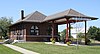
Small brick depot built in 1914 by the Green Bay and Western Railroad with separate waiting rooms for men and women. It replaced an earlier wooden depot built in 1877 by the Green Bay and Lake Pepin Railroad.[18]
City hall and opera house with clock tower, designed in Queen Anne style by C. G. Maybury & Sons of Winona. Begun in 1902, half-destroyed by the tornado in 1903, but then completed. Re-equipped as a movie theater in the 1920s.[20][21]
Ten contributing commercial buildings, ranging from wooden Boomtown-style stores built around 1880 to the 1888 Queen Anne E. J. Hankey General Store, to the 1912 Prairie School Citizens State Bank, to Dr. Pierce's office, built in 1915.[23]
First brewery in Trempealeau County, built in 1857 of sandstone blocks cut from the caves in the bluff behind the building. Prussian immigrant Jacob Melchoir brewed lager from locally grown wheat and stored it in those caves at 44 degrees year-round.[24]
Remnants of a group of 26 conical mounds. The mound pictured (Nicholls) contained Hopewell people buried in a bark structure with points and pipes traded from as far as the Rocky Mountains and Lake Superior.[26]
This is a list of the National Register of Historic Places listings in Sauk County, Wisconsin. It is intended to provide a comprehensive listing of entries in the National Register of Historic Places that are located in Sauk County, Wisconsin. The locations of National Register properties for which the latitude and longitude coordinates are included below may be seen in a map.
This is a list of the National Register of Historic Places listings in Brown County, Wisconsin. It is intended to provide a comprehensive listing of entries in the National Register of Historic Places that are located in Brown County, Wisconsin. The locations of National Register properties for which the latitude and longitude coordinates are included below may be seen in a map.
This is a list of the National Register of Historic Places listings in Door County, Wisconsin. It is intended to provide a comprehensive listing of entries in the National Register of Historic Places that are located in Door County, Wisconsin. The locations of National Register properties for which the latitude and longitude coordinates are included below may be seen in a map.
This is a list of the National Register of Historic Places listings in Eau Claire County, Wisconsin. It is intended to provide a comprehensive listing of entries in the National Register of Historic Places that are located in Eau Claire County, Wisconsin. The locations of National Register properties for which the latitude and longitude coordinates are included below may be seen in a map.
This is a list of the National Register of Historic Places listings in Walworth County, Wisconsin. It is intended to provide a comprehensive listing of entries in the National Register of Historic Places that are located in Walworth County, Wisconsin. The locations of National Register properties for which the latitude and longitude coordinates are included below may be seen in a map.
This is a list of the National Register of Historic Places listings in Ashland County, Wisconsin. It is intended to provide a comprehensive listing of entries in the National Register of Historic Places that are located in Ashland County, Wisconsin. The locations of National Register properties for which the latitude and longitude coordinates are included below may be seen in a map.
This is a list of the National Register of Historic Places listings in Bayfield County, Wisconsin. It is intended to provide a comprehensive listing of entries in the National Register of Historic Places that are located in Bayfield County, Wisconsin. The locations of National Register properties for which the latitude and longitude coordinates are included below may be seen in a map.
This is a list of the National Register of Historic Places listings in Douglas County, Wisconsin. It is intended to provide a comprehensive listing of entries in the National Register of Historic Places that are located in Douglas County, Wisconsin. The locations of National Register properties for which the latitude and longitude coordinates are included below may be seen in a map.
This is a list of the National Register of Historic Places listings in Portage County, Wisconsin. It is intended to provide a comprehensive listing of entries in the National Register of Historic Places that are located in Portage County, Wisconsin. The locations of National Register properties for which the latitude and longitude coordinates are included below may be seen in a map.
This is a list of the National Register of Historic Places listings in Chippewa County, Wisconsin. It is intended to provide a comprehensive listing of entries in the National Register of Historic Places that are located in Chippewa County, Wisconsin. The locations of National Register properties for which the latitude and longitude coordinates are included below may be seen in a map.
This is a list of the National Register of Historic Places listings in Waushara County, Wisconsin. It is intended to provide a comprehensive listing of entries in the National Register of Historic Places that are located in Waushara County, Wisconsin. The locations of National Register properties for which the latitude and longitude coordinates are included below may be seen in a map.
The John F. Cance House at 807 W. Ridge Ave. in Galesville, Wisconsin was built in 1908.
This is a list of the National Register of Historic Places listings in Buffalo County, Wisconsin. It is intended to provide a comprehensive listing of entries in the National Register of Historic Places that are located in Buffalo County, Wisconsin. The locations of National Register properties for which the latitude and longitude coordinates are included below may be seen in a map.
This is a list of the National Register of Historic Places listings in Price County, Wisconsin. It is intended to provide a comprehensive listing of entries in the National Register of Historic Places that are located in Price County, Wisconsin. The locations of National Register properties for which the latitude and longitude coordinates are included below may be seen in a map.
This is a list of the National Register of Historic Places listings in Vilas County, Wisconsin. It is intended to provide a comprehensive listing of entries in the National Register of Historic Places that are located in Vilas County, Wisconsin. The locations of National Register properties for which the latitude and longitude coordinates are included below may be seen in a map.
This is a list of the National Register of Historic Places listings in Wood County, Wisconsin. It is intended to provide a comprehensive listing of entries in the National Register of Historic Places that are located in Wood County, Wisconsin. The locations of National Register properties for which the latitude and longitude coordinates are included below may be seen in a map.
This is a list of the National Register of Historic Places listings in Taylor County, Wisconsin. It is intended to provide a comprehensive listing of entries in the National Register of Historic Places that are located in Taylor County, Wisconsin. The locations of National Register properties for which the latitude and longitude coordinates are included below may be seen in a map.
This is a list of the National Register of Historic Places listings in Iron County, Wisconsin. It is intended to provide a comprehensive listing of entries in the National Register of Historic Places that are located in Iron County, Wisconsin. The locations of National Register properties for which the latitude and longitude coordinates are included below may be seen in a map.
This is a list of the National Register of Historic Places listings in Jackson County, Wisconsin. It is intended to provide a comprehensive listing of entries in the National Register of Historic Places that are located in Jackson County, Wisconsin. The locations of National Register properties for which the latitude and longitude coordinates are included below may be seen in a map.
This is a list of the National Register of Historic Places listings in Sawyer County, Wisconsin. It is intended to provide a comprehensive listing of entries in the National Register of Historic Places that are located in Sawyer County, Wisconsin. The locations of National Register properties for which the latitude and longitude coordinates are included below may be seen in a map.
References
↑ The latitude and longitude information provided is primarily from the National Register Information System, and has been found to be fairly accurate for about 99% of listings. For 1%, the location info may be way off. We seek to correct the coordinate information wherever it is found to be erroneous. Please leave a note in the Discussion page for this article if you believe any specific location is incorrect.
1 2 Numbers represent an alphabetical ordering by significant words. Various colorings, defined here, differentiate National Historic Landmarks and historic districts from other NRHP buildings, structures, sites or objects.
↑ The eight-digit number below each date is the number assigned to each location in the National Register Information System database, which can be viewed by clicking the number.
↑ Pierce, Eben Douglas (1917). History of Trempealeau County. Chicago and Winona: H C Cooper Jr & Co. pp.434–435. Retrieved 2014-02-02. John Bohrnstedt AND galesville.
↑ "John F. Cance House". Architecture and History Inventory. Wisconsin Historical Society. Retrieved 2014-02-08.
↑ Boszhardt, Robert F.; Schrab, Geri (2016). Hidden Thunder: Rock Art of the Upper Midwest. State Historical Society of Wisconsin. pp.179–193. ISBN978-0-87020-768-6.
This page is based on this Wikipedia article Text is available under the CC BY-SA 4.0 license; additional terms may apply. Images, videos and audio are available under their respective licenses.