Old North End Historic District (Colorado Springs, Colorado)

Last updated
Old North Historic District
North End Historic District 04.JPG
USA Colorado location map.svg
Red pog.svg
Location of the Old North Historic District
Usa edcp location map.svg
Red pog.svg
Old North End Historic District (Colorado Springs, Colorado) (the United States)
LocationNeighborhood in the northern section of downtown Colorado Springs, Colorado
Coordinates 38°51′27″N104°49′21″W / 38.85750°N 104.82250°W / 38.85750; -104.82250 Coordinates: 38°51′27″N104°49′21″W / 38.85750°N 104.82250°W / 38.85750; -104.82250
Website oldnorthend.org
NRHP reference No. 82001017
CSRHP No.5EP.333
Significant dates
Added to NRHPDecember 17, 1982 [1]
Designated HD82001017
Designated CSRHP1982 [2]

Old North End Historic District of Colorado Springs, Colorado is located north of Colorado College [lower-alpha 1] between Monument Valley Park, an alley between Weber and Nevada Streets, and Uintah and Lilac Streets. It was called North End Historic District until September 2015 when the district boundaries were expanded and the neighborhood was renamed. [2]

Contents

The residential area was developed for middle and upper-class people in the late-nineteenth century. The architecture includes Spanish Colonial Revival, Georgian Revival, Mission architecture as well as more contemporary Modern Movement, International Style and Bungalow styles. The houses, built between 1885 and 1965 are generally in good condition. [2]

History Colorado, which register the district as a historic place, says of the neighborhood, "The architectural character of the district is also indicative of the various periods of growth in Colorado Springs, from the late-nineteenth century gold boom through the post-World War II population influx. In addition, a number of the district's homes were designed by well-known, influential architects of the day." [2] It was registered by the National Register of Historic Places in 1982. [2]

History

House in Old North End Historic District Old North End Historic District 02.jpg
House in Old North End Historic District

The first building constructed in the Old North End was a house for female students of Colorado College by its president, Edward Payson Tenney. Called the Columbian Club, the three-story Victorian house was built about 1881 with a covered porch, large dormer windows, and a steeple at Cascade Avenue and Columbia Street, four blocks north of the campus building, Cutler Hall. It burned down on January 1, 1884 while its occupants were away during the Christmas holiday. [4]

In the 1880s, Tenney built the first house for the president of the university on Cascade Avenue, north of San Rafael, the northern boundary of the city at that time. It is the current side of Loomis Hall, which was constructed in the mid-1950s. Colorado College, led by Tenney, purchased land as an investment in what became the Old North End. Called New Massachusetts, named for his New England background, the enterprise was not profitable due to the very slow growth of the city at that time. The college sold its interest in the endeavor at a loss and fired Tenney. By 1888, the Old North End district was primarily grassland with a few houses. [5]

House in Old North End Historic District Old North End Historic District 04.jpg
House in Old North End Historic District

Many homes were built in the neighborhood during a period of significant growth between 1890 and 1910, largely due to the success of the gold mines in Cripple Creek and Victor and resulting industry in the city of Colorado Springs. There were more than 400 mining companies and three mining exchanges established in Colorado Springs. Colorado Springs Mining Exchange became successful, trading "more shares than any other exchange in the world." The population of the city doubled between 1890 and 1900. [6] [7]

Architects Charles Thomas, Thomas MacLaren, E.C.G Robinson, Nicholas Van den Arend, and Douglas & Hetherington designed Tudor, Colonial Revival, Queen Anne and other style houses. Residents included the middle class, like gold stock brokers, Cripple Creek area mine manages, doctors, and judges. [6] Some of the houses were built with sleeping porches for people who had moved to the dry, mountain climate of Colorado Springs to cure their tuberculosis, like Marshall Sprague. [6] [8] The 1200 and 1300 blocks of Wood Avenue, nicknamed Millionaires Row, was the site of mansions to many of the 50 North End millionaires, like mine like mine owners Nelson B. Williams and James Ferguson Burns who owned the Williams Burns Mansion (later converted to apartments) at 1315 Wood Avenue [9] [10] [11] and O.C. Townsend. Before it was renamed, the street was named Earl's Court. [12]

Colorado Springs & Interurban Railroad car, 1907 or 1908 Colorado Springs & Interurban Railroad car 1907 or 1908.jpg
Colorado Springs & Interurban Railroad car, 1907 or 1908

Streetcars, operated by the Colorado Springs and Interurban Railway, provided service for the North End on the main north / south route on Tejon Street, on North Weber from downtown to Fontanero, and eastward on Fontanero. [13] [14] [15] Having transitioned from horse-drawn cars, there were 44 electric trolleys in 1900. [13] Streetcars operated until the 1930s. [16]

Stewart House Old North End Historic District - Stewart House.jpg
Stewart House

The 1200 block of Wood Avenue is the site of the second president's house for Colorado College and Stewart House, which was donated to the institution by Philip B. Stewart. Also on the block is the former house of Alice Bemis Taylor who was a significant benefactor to the school. Taylor Dining Hall, now a theater, was named for her and Bemis Hall was named for her father. Charles L. Tutt Sr.'s house at Uintah and Cascade was donated to the college and is now the Tutt Alumni House. [17]

House in Old North End Historic District Old North End Historic District 05.jpg
House in Old North End Historic District

The neighborhood has remained stable into and through the 20th century due to the growth of Colorado College, Glockner and then Penrose Hospitals, and businesses and the court in downtown Colorado Springs. Homeowners have included physicians from the hospitals, college professors, lawyers, and businesspeople. [18]

During World War II, apartments were created in garages, basements, and entire houses, which were used for residences for military stationed at training facilities at Camp Carson and Peterson Field. [19]

Medical care

Tuberculosis

In the late 19th century, people afflicted with tuberculosis came to Colorado Springs, one of several Rocky Mountain locations, for its high altitude and cool, dry air. In the North End, there were convalescent homes and the Glockner Tuberculosis Sanatorium. [20] A fully restored tuberculosis hut, or tent cottage, and its early 20th century furnishings that was used by people who came to the Colorado Springs area to cure their tuberculosis is located at the corner of Jackson Street and Cascade Avenue. [21]

Glockner Tuberculosis Sanatorium

Marie Gwynne Glockner opened the Glockner Tuberculosis Sanatorium at 2200 N. Tejon in 1890 as a memorial to her husband, Dr. Albert Glockner, who had died of tuberculosis at 31 years of age. The first superintendent was Dr. Boswell P. Anderson, a former Colorado Midland Railway physician. [22] [23] [24] [25] In 1893, Glockner gave the sanatorium to the Sisters of Charity of Cincinnati, who were brought in for their care-giving and professional skills. [26] It was the Glockner Sanatorium and Training School for Nurses by 1916 [24] and the Glockner Sanatorium and Hospital in 1940. [27] Glockner evolved over the years into Penrose Hospital. The Glockner Hospital was razed in 1959 for the construction of a new Penrose Hospital building, costing $10 million. [23]

Notes

  1. Colorado College was the northmost area of Colorado Springs through the 1880s. [3]

Related Research Articles

<span class="mw-page-title-main">Manitou Springs, Colorado</span> City in Colorado, United States

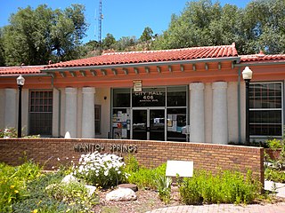
Manitou Springs is a home rule municipality located at the foot of Pikes Peak in western El Paso County, Colorado, United States. The town was founded for its natural mineral springs. The downtown area continues to be of interest to travelers, particularly in the summer, with many shops and restaurants, as well as a creekside city park. The main road through the center of town was one of the direct paths to the base of Pikes Peak. Barr Trail, which winds its way up Pikes Peak, is accessible from town. The subdivision Crystal Hills was added to the municipality in the 1960s.

<span class="mw-page-title-main">South Lake Union, Seattle</span> Neighborhood of Seattle

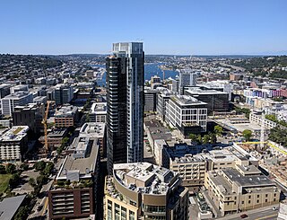
South Lake Union is a neighborhood in Seattle, Washington, so named because it is at the southern tip of Lake Union.

<span class="mw-page-title-main">Spencer Penrose</span>

Spencer Penrose was an American entrepreneur and philanthropist. He made his fortune from mining, ore processing, and real estate speculation in Colorado and other parts of the West. He founded the Utah Copper Company in 1903, and also established mining operations in Arizona, New Mexico and Nevada.

<span class="mw-page-title-main">Cascade, Colorado</span> Unincorporated community in State of Colorado, United States

Cascade is an unincorporated community and U.S. Post Office in El Paso County, Colorado, United States. The ZIP Code of the Cascade Post Office is 80809.

<span class="mw-page-title-main">Old Colorado City</span> Place in Colorado, United States

Old Colorado City, formerly Colorado City, was once a town, but it is now a neighborhood within the city of Colorado Springs, Colorado. Its commercial district was listed on the National Register of Historic Places in 1982. It was founded during the Pikes Peak Gold Rush of 1859 and was involved in the mining industry, both as a supply hub and as a gold ore processing center beginning in the 1890s. Residents of Colorado City worked at some of the 50 coal mines of the Colorado Springs area. It was briefly the capital of the Colorado Territory. For many years, Colorado Springs prohibited the use of alcohol within its border due to the lifestyle of Colorado City's opium dens, bordellos, and saloons. It is now a tourist area, with boutiques, art galleries, and restaurants.

<span class="mw-page-title-main">History of Colorado Springs, Colorado</span> Place in Colorado, United States

Before it was founded, the site of modern-day Colorado Springs, Colorado, was part of the American frontier. Old Colorado City, built in 1859 during the Pike's Peak Gold Rush was the Colorado Territory capital. The town of Colorado Springs, was founded by General William Jackson Palmer as a resort town. Old Colorado City was annexed into Colorado Springs. Railroads brought tourists and visitors to the area from other parts of the United States and abroad. The city was noted for junctions for seven railways: Denver and Rio Grande (1870), Denver and New Orleans Manitou Branch (1882), Colorado Midland (1886-1918), Colorado Springs and Interurban, Atchison, Topeka, and Santa Fe (1889), Rock Island (1889), and Colorado Springs and Cripple Creek Railways. It was also known for mining exchanges and brokers for the Cripple Creek Gold Rush.

Charles Leaming Tutt Sr. and his descendants are famous in Colorado Springs. He became a wealthy man by the time he was forty years old.

<span class="mw-page-title-main">Manitou Springs Historic District</span> Historic district in Colorado, United States

Manitou Springs Historic District in Manitou Springs, Colorado is roughly bounded by US 24, Ruxton Avenue, El Paso Boulevard and Iron Mountain Avenue. Listed in the National Register of Historic Places, it is one of the country's largest National Historic Districts.

Boulder Crescent Place Historic District is a historic area in Colorado Springs, Colorado along West Boulder and Cascade Avenue near the intersection of the two streets. It is a National Register of Historic Places listing and is on the Colorado State Register of Historic Properties.

Alice Bemis Taylor was a philanthropist and was inducted into the Colorado Women's Hall of Fame in 2010.

<span class="mw-page-title-main">Penrose Hospital</span> Hospital in Colorado, United States

Penrose Hospital is a 364-bed hospital hospital located in Colorado Springs, Colorado and owned by Penrose-Saint Francis Health Services. The campus includes Penrose Hospital, the Penrose Cancer Center, the E Tower building, the Penrose Pavilion, and John Zay House.

Roswell, now annexed into the city of Colorado Springs, Colorado, was a coal mine settlement near the northern bluffs of Colorado Springs and a 19th-century railroad junction. The town was located at roughly the present intersection of Fillmore Street and North Nevada Avenue in Colorado Springs.

The National Methodist Sanatorium was a 1926 medical facility on Boulder Street in Colorado Springs, Colorado. It was near the Beth-El Hospital, which is now Memorial Hospital. The Sanatorium was later used as the Air Defense Command and North American Aerospace Defense Command (NORAD) headquarters on Ent Air Force Base.

The town of Colorado Springs, Colorado played an important role in the history of tuberculosis in the era before antituberculosis drugs and vaccines. Tuberculosis management before this era was difficult and often of limited effect. In the 19th century, a movement for tuberculosis treatment in hospital-like facilities called sanatoriums became prominent, especially in Europe and North America. Thus people sought tuberculosis treatment in Colorado Springs because of its dry climate and fresh mountain air. Some people stayed in boarding houses, while others sought the hospital-like facilities of sanatoriums. In the 1880s and 1890s, it is estimated that one-third of the people living in Colorado Springs had tuberculosis. The number of sanatoriums and hospitals increased into the twentieth century. During World War II, medicines were developed that successfully treated tuberculosis and by the late 1940s specialized tuberculosis treatment facilities were no longer needed.

<span class="mw-page-title-main">Colorado Springs and Interurban Railway</span>

The Colorado Springs and Interurban Railway was an electric trolley system in the Colorado Springs, Colorado that operated from 1902 to 1932. The company was formed when Winfield Scott Stratton purchased Colorado Springs Rapid Transit Railway in 1901 and consolidated it in 1902 with the Colorado Springs & Suburban Railway Company. It operated in Colorado Springs, its suburbs, and Manitou Springs. One of the street cars from Stratton's first order is listed on the Colorado State Register of Historic Properties.

<span class="mw-page-title-main">Cheyenne Mountain</span> Mountain in El Paso County, Colorado, US

Cheyenne Mountain is a triple-peaked mountain in El Paso County, Colorado, southwest of downtown Colorado Springs. The mountain serves as a host for military, communications, recreational, and residential functions. The underground operations center for the North American Aerospace Defense Command (NORAD) was built during the Cold War to monitor North American airspace for missile launches and Soviet military aircraft. Built deep within granite, it was designed to withstand the impact and fallout from a nuclear bomb. Its function broadened with the end of the Cold War, and then many of its functions were transferred to Peterson Air Force Base in 2006.

Charles Blevins Davis was an American playwright and theatrical producer.

<span class="mw-page-title-main">Cragmor, Colorado</span> Area in Colorado, United States

Cragmor, first known as Cragmoor, is an area in northeastern Colorado Springs, Colorado, between Templeton Gap and Austin Bluffs. The site of coal mines in the 19th century, after the turn of the century it became known as the Cragmor area for the Cragmor Sanitorium. By the 1950s, the mines were abandoned and the land was developed for housing. Cragmor was annexed to the City of Colorado Springs in the early 1960s. The Cragmor Sanatorium became the main hall for the University of Colorado Colorado Springs campus.

<span class="mw-page-title-main">Marshall Sprague</span> American journalist and author

Marshall Sprague was an American journalist in New York, Paris, and China and writer of books about western United States history. From Ohio, he moved to Colorado Springs, Colorado to recuperate following a diagnosis of tuberculosis and settled there. He received the Colorado Authors League Top Hand Award for Massacre: The Tragedy At White River and A Gallery of Dudes.

Julia (Julie) Villiers Lewis McMillan Penrose (1870–1956) was a wealthy American philanthropist born to a prominent family, the wife of the James (Jim) McMillan until he died in 1902, then the wife of millionaire Spencer Penrose until his death in 1939. Julie's giving during her marriages, contributions to the region around her, and the state of Colorado, continued even after death with the creation of the perpetual El Pomar Foundation.

References

  1. "National Register Information System". National Register of Historic Places . National Park Service. January 23, 2007.
  2. 1 2 3 4 5 "El Paso County - Colorado State Register of Historic Properties". History Colorado. Archived from the original on December 24, 2013. Retrieved May 9, 2017.
  3. Loevy 2010, p. 2.
  4. Loevy 2010, pp. 2–3.
  5. Loevy 2010, pp. 3–4.
  6. 1 2 3 Kate Jonuska. "Local History Hides in Plain Site" (PDF). Colorado Springs Gazette. Retrieved May 10, 2017.
  7. Loevy 2010, pp. 4–6.
  8. Loevy 2010, p. 11.
  9. Stewart M. Green (June 4, 2013). Scenic Routes & BywaysTM Colorado. Rowman & Littlefield. p. 102. ISBN   978-0-7627-9588-8.
  10. Brian Levine (January 1, 1988). Cripple Creek Gold: A Centennial History of the Cripple Creek District. The Depot. p. 84. ISBN   978-0-943645-15-5.
  11. Loevy 2010, pp. 6–7.
  12. "Residence of O. C. Townsend". Pikes Peak Library District digital collections. Retrieved May 10, 2017.
  13. 1 2 "Colorado Springs Trolleys: About us". Pikes Peak Historical Street Railway Foundation, Colorado Springs & Interurban Railway. Archived from the original on February 5, 2015. Retrieved 2015-01-15.
  14. Charles Mulford Robinson (1912). A General Plan for the Improvement of Colorado Springs. p. 21.
  15. Loevy 2010, pp. 15, 16.
  16. Loevy 2010, p. 16.
  17. Loevy 2010, pp. 9–10.
  18. Loevy 2010, p. 14.
  19. Loevy 2010, p. 22.
  20. Loevy 2010, p. 10.
  21. Linda Navarro (January 10, 2014). "Projects Honored as the Best in Historic Preservation". The Gazette. Colorado Springs, Colorado.[ dead link ]
  22. Sherlock 2013, p. 352.
  23. 1 2 Bill Vogrin (December 6, 2012). "Side Streets: Celebrating Lorraine Crocker's Century in the Springs". The Gazette. Colorado Springs, Colorado.[ dead link ]
  24. 1 2 Colorado Springs, Colorado City and Manitou City Directory (PDF). Vol. XIII. The R. L. Polk Directory Co. 1916. pp. 20–21. Retrieved November 15, 2013 via Pikes Peak Library District.
  25. Tim Blevins; Dennis Daily; Sydne Dean; Chris Nicholl; Michael L. Olsen; Katherine Scott Sturdevant; Amy Ziegler, eds. (2012). Doctors, Disease, and Dying (Google books). ISBN   9781567352818 . Retrieved 2013-12-09.
  26. Sherlock 2013, p. xvi, 352.
  27. Telephone Directory...for Colorado Springs... (PDF), The Mountain States Telephone and Telegraph Company, Spring 1940, p. 16, retrieved 2013-11-24

Sources

Further reading

External images
Searchtool.svg 1205 Wood Avenue (initially numbered and named 1201 Earl's Court, home of O.C. Townsend (after 1894)
Searchtool.svg 1238 Wood Avenue, home of Alice Bemis Taylor
Searchtool.svg 1320 Wood Avenue, home of Lawrence Bodribb
Searchtool.svg 1830 Wood Avenue