
The following outline is provided as an overview of and topical guide to the Isle of Man:
Contents
- General reference
- Geography of the Isle of Man
- Location of the Isle of Man
- Environment of Isle of Man
- Administrative divisions of the Isle of Man
- Demography of the Isle of Man
- Neighbouring countries
- Government and politics of the Isle of Man
- Branches of the government of the Isle of Man
- External relations of the Isle of Man
- Law and order in the Isle of Man
- Military of the Isle of Man
- Emergency services in the Isle of Man
- Local government in the Isle of Man
- History of the Isle of Man
- Culture of the Isle of Man
- Art in the Isle of Man
- Sport in the Isle of Man
- Economy and infrastructure of the Isle of Man
- Education in the Isle of Man
- See also
- References
- External links
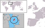
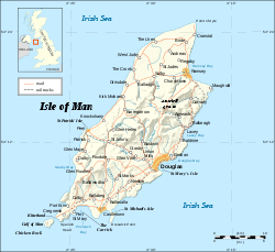
Isle of Man – self-governing British Crown dependency located in the Irish Sea near the geographic centre of the British Isles. [1] The head of state is King Charles III, who holds the title of Lord of Mann. The Crown is represented by a lieutenant governor. The island is not part of the United Kingdom, but external relations, defence, and ultimate good governance of the Isle of Man are the responsibility of the government of the United Kingdom.


