Perrysburg (town), New York

Last updated
Perrysburg, New York
USA New York location map.svg
Red pog.svg
Perrysburg
Location in the state of New York
Coordinates: 42°29′3″N79°0′54″W / 42.48417°N 79.01500°W / 42.48417; -79.01500
Country United States
State New York
County Cattaraugus
Government
  Type Town Council
   Town Supervisor Dennis C. Stopen (D, R)
   Town Council
Members' List
Area
[1]
  Total28.55 sq mi (73.94 km2)
  Land28.42 sq mi (73.61 km2)
  Water0.13 sq mi (0.33 km2)
Elevation
1,080 ft (330 m)
Population
 (2020) [2]
  Total1,515
  Estimate 
(2021) [2]
1,502
  Density55.73/sq mi (21.52/km2)
Time zone Eastern (EST)
ZIP code
14129
FIPS code 36-009-57298
Website www.perrysburgny.org

Perrysburg is a town in Cattaraugus County, New York, United States. The population was 1,515 at the 2020 census [2] . The town is named after Commodore Oliver Hazard Perry and is located in the northwest corner of the county. The town contains the census-designated place also named Perrysburg, formerly an incorporated village.

Contents

History

The town of Perrysburg was formed in 1814 as the "town of Perry" from the towns of Hebe and Olean. It originally consisted of the entire western half of the county and was created because the county did not yet have a centralized government; Hebe and Olean were administered as part of Allegany County. Perry was governed as part of Niagara County (which at the time also covered the entirety of what is now Erie County) until Cattaraugus County achieved self-government in 1817.

In 1818, the same year Little Valley and Great Valley were split off to govern the southwest part of the county, the town changed its name to "Perrysburgh". Eventually, likely at the behest of the United States Board on Geographic Names during the Benjamin Harrison administration in the 1890s, the spelling became "Perrysburg." Over the course of the 19th century, the town was divided to form what are now all of the towns in northwestern Cattaraugus County: Dayton, Persia, Otto, East Otto, Mansfield, New Albion, and Leon.

Geography

According to the United States Census Bureau, the town has a total area of 28.5 square miles (73.9 km2), of which 28.4 square miles (73.6 km2) is land and 0.12 square miles (0.3 km2), or 0.44%, is water. [3]

The northern border is Cattaraugus Creek with Erie County on the opposite bank. The western border is Chautauqua County.

The town's geographic location results in frequent and heavy lake-effect snow events during the fall and winter. It is often the site for maximum snowfall accumulations. A hill rising to over 1,600 feet (490 m) on the southern edge of the town contributes to orographic enhancement, intensifying snowfall. From December 10 through December 17, 2013 nearly 7 feet (2.1 m) (84 in or 2,100 mm) of snow fell on the town, with the majority of it being lake-effect snow. Some locals have named Perrysburg the snow capital of Western New York.

New York State Route 39 is an east-west highway through the town.

Adjacent towns and areas

To the west is the town of Hanover in Chautauqua County. The southern border is formed with the town of Dayton. The eastern border is the town of Persia and the village of Gowanda. The northern border is formed with the Cattaraugus Reservation and the town of Brant in Erie County.

Demographics

Historical population
CensusPop.
1820 835
1830 2,440192.2%
1840 1,660−32.0%
1850 1,86112.1%
1860 1,439−22.7%
1870 1,313−8.8%
1880 1,3764.8%
1890 1,123−18.4%
1900 1,067−5.0%
1910 1,004−5.9%
1920 1,15014.5%
1930 1,35818.1%
1940 1,80532.9%
1950 1,507−16.5%
1960 1,85723.2%
1970 2,23620.4%
1980 2,180−2.5%
1990 1,838−15.7%
2000 1,771−3.6%
2010 1,626−8.2%
2020 1,515−6.8%
2021 (est.)1,502 [2] −0.9%
U.S. Decennial Census [4]

As of the census [5] of 2000, there were 1,771 people, 685 households, and 487 families residing in the town. The population density was 62.1 people per square mile (24.0/km2). There were 752 housing units at an average density of 26.4 per square mile (10.2/km2). The racial makeup of the town was 94.52% White, 0.34% Black or African American, 3.39% Native American, 0.06% Asian, 0.34% from other races, and 1.36% from two or more races. Hispanic or Latino of any race were 0.62% of the population.

There were 685 households, out of which 28.9% had children under the age of 18 living with them, 56.1% were married couples living together, 11.4% had a female householder with no husband present, and 28.8% were non-families. 24.4% of all households were made up of individuals, and 11.1% had someone living alone who was 65 years of age or older. The average household size was 2.46 and the average family size was 2.87.

In the town, the population was spread out, with 22.3% under the age of 18, 6.8% from 18 to 24, 28.0% from 25 to 44, 26.6% from 45 to 64, and 16.3% who were 65 years of age or older. The median age was 41 years. For every 100 females, there were 100.1 males. For every 100 females age 18 and over, there were 98.8 males.

The median income for a household in the town was $37,212, and the median income for a family was $44,231. Males had a median income of $34,028 versus $23,828 for females. The per capita income for the town was $17,453. About 7.1% of families and 13.4% of the population were below the poverty line, including 18.7% of those under age 18 and 14.1% of those age 65 or over.

Communities and locations in the Town of Perrysburg

Notable people

Related Research Articles

Cattaraugus County, New York County in New York, United States

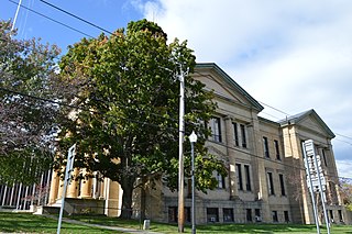
Cattaraugus County is a county in western New York, with one side bordering Pennsylvania. As of the United States 2020 census, the population was 77,042. The county seat is Little Valley. The county was created in 1808 and later organized in 1817.

Chautauqua County, New York County in New York, United States

Chautauqua County is the westernmost county in the U.S. state of New York. As of the 2020 census, the population was 127,657. Its county seat is Mayville, and its largest city is Jamestown. Its name is believed to be the lone surviving remnant of the Erie language, a tongue lost in the 17th century Beaver Wars; its meaning is unknown and a subject of speculation. The county was created in 1808 and organized in 1811.

Ashford is a town in Cattaraugus County, New York, United States. The population was 1,974 at the 2020 census. The town is on the county's northern border.

Carrollton, New York Town in New York, United States

Carrollton is a town in Cattaraugus County, New York, United States. The population was 1,214 at the 2020 census. The town was named after Guy Carrollton Irvine, an early settler of the region.

Conewango is a town in Cattaraugus County, New York, United States. The population was 1,794 at the 2020 census. The town is named after a creek which flows through the town.

Dayton, New York Town in New York, United States

Dayton is a town in Cattaraugus County, New York, United States. The population was 1,689 at the 2020 census. The town is on the western border of Cattaraugus County.

Hinsdale, New York Town in New York, United States

Hinsdale is a town in Cattaraugus County, New York, United States. The population was 2,119 at the 2020 census. The town was named after Hinsdale in New Hampshire.

New Albion, New York Town in New York, United States

New Albion is a town in Cattaraugus County, New York, United States. The population was 1,990 at the 2020 census. The town is named after Albion in Orleans County, the source of some early settlers. New Albion is in the northwest quadrant of the county, northwest of the city of Salamanca.

Otto, New York Town in New York, United States

Otto is a town in Cattaraugus County, New York, United States. The population was 775 at the 2020 census. The name comes from Jacob S. Otto, an agent of the Holland Land Company. The town lies on the northern border of Cattaraugus County.

Persia, New York Town in New York, United States

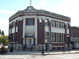
Persia is a town in Cattaraugus County, New York, United States. The population was 2,203 at the 2020 census. It is in the northwest part of the county. The village of Gowanda is partially in the town.

South Valley is a town in Cattaraugus County, New York, United States. The population was 250 at the 2020 census. The name is derived from the town's geographical attributes.

Brocton is a village in Chautauqua County, New York, United States. The name was derived by combining the names "Brockway" and "Minton", two prominent local families. The population was 1,335 at the 2020 census. Brocton is within the town of Portland.

Hanover, New York Town in New York, United States

Hanover is a town in Chautauqua County, New York, United States. The population was 6,893 at the 2020 census. The town lies in the northeast corner of Chautauqua County.

Brant, New York Town in New York, United States

Brant is a town in Erie County, New York, United States. As of the 2010 U.S. census, the town had a population of 2,065. The town was named after the Mohawk leader Joseph Brant.

Cattaraugus Reservation is an Indian reservation located partly in Cattaraugus County, New York, United States. The population was 314 at the 2010 census. The majority of the residents are of the federally recognized Seneca Nation, one of the original Five Nations of the Iroquois Confederacy.

Cattaraugus Reservation is an Indian reservation of the Seneca Nation of New York, located partly in Chautauqua County, New York, United States. The population of this portion of the reservation was 38 at the 2010 census. Most of the inhabitants are of the Seneca tribe.

Cattaraugus Reservation, Erie County, New York Indian reservation in New York, United States

Cattaraugus Reservation is an Indian reservation located partly in Erie County, New York, United States. The population was 1,833 at the 2010 census.

Allegany is a town in Cattaraugus County, New York, United States. The population was 7,493 at the 2020 census.

Olean is a town in Cattaraugus County, New York, United States. The population was 1,890 at the 2020 census. The name is derived from the Latin word "oleum" due to the discovery of crude oil in nearby Ischua.

Perrysburg is a hamlet, census-designated place, and former village in Cattaraugus County, New York, United States. The population was 401 at the 2010 census. It is named after Commodore Oliver Hazard Perry. The community is in the south-central part of the town of Perrysburg. The hamlet is west of Gowanda.

References

  1. "2016 U.S. Gazetteer Files". United States Census Bureau. Retrieved Jul 4, 2017.
  2. 1 2 3 4 Bureau, US Census. "City and Town Population Totals: 2020-2021". Census.gov. US Census Bureau. Retrieved 5 July 2022.
  3. "Geographic Identifiers: 2010 Demographic Profile Data (G001): Perrysburg town, Cattaraugus County, New York". U.S. Census Bureau, American Factfinder. Archived from the original on February 12, 2020. Retrieved October 28, 2014.
  4. "Census of Population and Housing". Census.gov. Retrieved June 4, 2015.
  5. "U.S. Census website". United States Census Bureau . Retrieved 2008-01-31.

Coordinates: 42°27′28″N79°00′03″W / 42.45778°N 79.00083°W / 42.45778; -79.00083