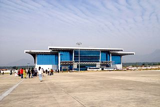
Trivandrum International Airport is an international airport which primarily serves the city of Thiruvananthapuram and it's adjacent cities and towns. It is the first airport in the state of Kerala, India and the fifth international airport of India declared by then Prime Minister of India, V. P. Singh in 1991.
Almora district is a district in the Kumaon division of Uttarakhand state, India. The headquarters is at Almora. It is 1,638 meters above sea level. The town of Almora is surrounded by Pithoragarh district to the east, Garhwal region to the west, Bageshwar district to the north and Nainital district to the south.

Calicut International Airport, also known as Karipur Airport, is an international airport serving the cities of Kozhikode and Malappuram in Kerala, India. The airport opened on 13 April 1988. It is located in Karipur, about 28 km (17 mi) from Kozhikode and 25 km (16 mi) from Malappuram. The airport serves as an operating base for Air India Express. It was the twelfth-busiest airport in India in terms of overall passenger traffic. It is the third-busiest airport in Kerala after Kochi and Thiruvananthapuram. It was given international airport status on 2 February 2006.

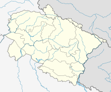
Pithoragarh district is the easternmost Himalayan district in the state of Uttarakhand, India. It is naturally landscaped with high Himalayan mountains, snow-capped peaks, passes, valleys, alpine meadows, forests, waterfalls, perennial rivers, glaciers, and springs. The flora and fauna of the area have rich ecological diversity. Pithoragarh has many temples and ruined forts from the once flourishing reign of the warrior Chand Kingdom.

Allahabad Airport is a military airbase and public airport serving the city of Allahabad, in the state of Uttar Pradesh, India. It is located in Bamrauli at a distance of 12 km (7.5 mi) from Allahabad city and is operational for domestic flights. It is one of the oldest airports in India.

Lohaghat is a town and a nagar panchayat in Champawat district in the Indian state of Uttarakhand. Lohaghat is a very beautiful hill station with many tourist spots around.

Rajiv Gandhi International Airport is an international airport that serves Hyderabad, the capital of the Indian state of Telangana. It is located in Shamshabad, about 24 kilometres (15 mi) south of Hyderabad. It was opened on 23 March 2008 to replace Begumpet Airport. It is named after Rajiv Gandhi, former Prime Minister of India.
Dehradun Airport also known as Jolly Grant Airport is a Domestic airport located about 30 km (19 mi) southeast of Dehradun, Uttarakhand, India. Nestled in the foothills of the Himalayas, the airport resumed commercial operations on 30 March 2008 after a runway extension to accommodate larger aircraft. A new terminal building was inaugurated in February 2009. Located 21 km (13 mi) from Rishikesh, and 44 km (27 mi) from Haridwar, the airport allows easy access to the region. It is approximately a 20 minutes drive to Rishikesh and 60 minutes to Haridwar and Dehradun.
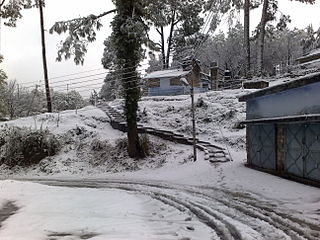
Berinag, is a hill station, located 160 km from Nainital in the Pithoragarh district, which is the easternmost Himalayan district in the state of Uttarakhand, India. It is one of the six Administrative Subdivisions (tehsil) of Pithoragarh. National Highway 309A passes through Berinag. Closest prominent villages include Garawon, Dhanoli, Bana, Bhattigaon, Banoli, Quarali, Tripuradevi and Sangarh.

Daporijo Airport is located at Daporijo in the state of Arunachal Pradesh, India. Daporijo used to have scheduled services in the 1980s and early 1990s from Vayudoot. The airport had flights to Guwahati and Dibrugarh on Dornier Do 228 aircraft. Currently, there is no scheduled commercial air service to the airport, although the airport is used by the Indian Army. The Airports Authority of India (AAI) plans to develop the airport for operation of ATR-42/ATR-72 type of aircraft.

Kullu–Manali Airport is an airport located in Bhuntar in the Indian state of Himachal Pradesh. The airport is located 11 km from Kullu and 52 km from Manali.

Vellore Airport is located in Vellore, Tamil Nadu, India. It serves Tiruvannamalai and Vellore districts. The airport was revived under the Regional Connectivity Scheme (RCS) of the MoCA in 2018. The AAI is planning to expand the airport by 66 acres to extend the airstrip and make it suitable for operation of a 20-seater aircraft under RCS. Currently runway and terminal building works are under progress, all the required infrastructure works are scheduled to be ready by June-2019 for operations.
Pantnagar Airport is a domestic airport located in Pantnagar of Udham Singh Nagar district in the Indian state of Uttarakhand. It is operated by the Airports Authority of India. It is the nearest airport to the Kumaon hill stations of Nainital (65 km), Bhimtal (50 km), Ranikhet (110 km) and Almora (120 km), Bareilly (65 km) and the Jim Corbett National Park (120 km).
Rupshir Airport is an airport located about 15 km (8.1 NM) from Dhubri town, in Assam, India. The airstrip has remained defunct since the 1980s. The Airports Authority of India (AAI) and the Indian Air Force (IAF) have begun work to revive the airfield. Civil operations to the airport will be begun under the Government's Regional Connectivity Scheme.

Aviation in India, broadly divided into military and civil aviation, is the fastest-growing aviation market in the world and Bangalore with 65% national share is the largest aviation manufacturing hub of India. UDAN scheme is driving the growth of civil aviation connectivity and infrastructure in India.
DeogharAirport is an International airport located at New Deoghar, in the state of Jharkhand, India. The airport is spread over 654 acres.

Gurugram Airstrip, also Bhondsi Airstrip and Silokhera Airstrip, is an airstrip located between Silokhera and Bhondsi villages, 10 kilometres (6.2 mi) south of Gurugram city center, in Haryana state of India.
Jhaltola is a small village situated between Chaukori and Patal Bhuvanshwar in the highlands of Uttarakhand state in northern India. It is one of several small villages in the area, with the advantage of being located near Highway 309A.

Lalgarh Airport is located at Lalgarh jattan, 26 kilometres South-East of Sri Ganganagar, in the state of Rajasthan, India. It is owned and operated by the State Government of Rajasthan. The airport is spread over 65 acres, has a 1300 metre long runway and a 4410 square metre apron for two small aircraft. A 125 square metre rest house serves as a terminal building.